
Spuks
-
Posts
23 -
Joined
-
Last visited
Content Type
Profiles
Forums
Events
Everything posted by Spuks
-
Hi, its qoute from book "Luftwaffe Airfields 1935-45 France": Rônai (FR) (48 48 45 N – 00 09 10 W) General: landing ground in Normandy, 11.5 km NW of Argentan, 10 km SSE of Falaise and 1.2 km WSW of the village of Rônai. History: prepared late spring/early summer 1944 and thought to be serviceable by the first week of July. Surface and Dimensions: grass or dirt strip measuring approx. 1100 x 230 meters (1200 x 250 yards). Infrastructure: none noted. [Sources: AFHRA A5259 p.1821 (6 Jul 44); chronologies; BA-MA; NARA; PRO/NA; web site ww2.dk] https://remonterletemps.ign.fr/comparer/basic?x=-0.147993&y=48.812223&z=15&layer1=GEOGRAPHICALGRIDSYSTEMS.MAPS.SCAN50.1950&layer2=ORTHOIMAGERY.ORTHOPHOTOS.1950-1965&mode=doubleMap

-
 Yes you're right. Any way if there is going to be development of radar station sites, Distelfunk should be done definitely. What about Mammut, as stated in wikipedia (https://en.m.wikipedia.org/wiki/Mammut_radar) this radar foundation located near Fecamp.
 -
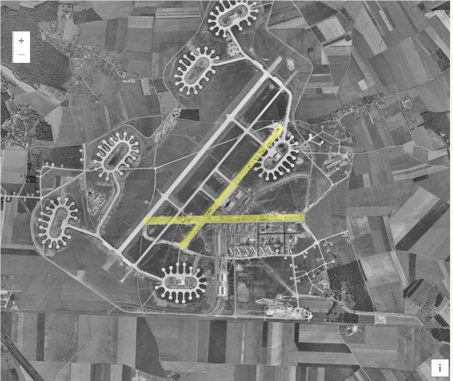
By the way Evreux-Fauville takeoff runway is not orientated corectly, alignment should be: first runway 1645 meters aligned NE/SW, second 1600 meters aligned E/W. Since this is a flight simulator, I think airfields are the second most important thing after the airplane. It would be great if Ugra-Media recreated the airfields as accurately as possible.
-
This map version would be perfect
-
There you go, i merged maps for you. No thanksgiving needed
-
Yes you are right, Saipan should be visible. Conclusion, its Guam. Any way i hope it is a montage in video for eye, to show much more spectacular view. Because airfield shown in video doesn't machup any airstrip builded by japanese.
-
It can't be this section of Guam, because in that place hadn't been airfield. Looking at your first post picture, island shapes much more similar to Tinian and airfield should be No.2.
-
Will the airfields have radio homing beacons?
Spuks replied to Gunfreak's topic in DCS: Normandy 2.0
yep you are right, i missed that -
Will the airfields have radio homing beacons?
Spuks replied to Gunfreak's topic in DCS: Normandy 2.0
Conches: grass surface on clay sub-soil. There were 2 concrete runways - (1) 1830 meters (2000 yards) aligned NE/SW, and (2) 1600 meters (1750 yards) aligned NW/SE. Each runway had an assembly hardstand at both ends. A perimeter road encircled the landing area. Both runways were equipped with permanent illumination and visual Lorenz systems, while the airfield had perimeter lighting and a beam approach system. At least Montdidier had this Lorenz system too. -
Major and most needable airfields in France for Normandy battles are shown in this map, i think
-
Same here, from Mission 6 ATC tower has no response. I found that all radio frequency same like squadron, but different from airfield ATC tower. I think that is hint for solution issue.
-
Ups it's my fault, i shouldn't touch oxygen emergency bypass valve.
-
Oxygen level drops to zero even it closed, after engine start. Stable Version DCS 2.7.5.10869 I would like add track but it too heavy (15MB) just after few minutes of playing. There in forum i can add just 5MB files.
-
It had been posted in similar topic, but i share it once again in wishlist. Airfields should be fixed: Evreux runway alignment(marked in yellow): (1) approx. 1645 meters (1800 yards) aligned NE/SW, and (2) approx. 1600 meters (1750 yards) aligned E/W. null https://remonterletemps.ign.fr/comparer/basic?x=1.222066&y=49.025966&z=14&layer1=GEOGRAPHICALGRIDSYSTEMS.MAPS.SCAN50.1950&layer2=ORTHOIMAGERY.ORTHOPHOTOS.1950-1965&mode=doubleMap Conches: grass surface on clay sub-soil. There were 2 concrete runways - (1) 1830 meters (2000 yards) aligned NE/SW, and (2) 1600 meters (1750 yards) aligned NW/SE. Each runway had an assembly hardstand at both ends. A perimeter road encircled the landing area. Both runways were equipped with permanent illumination and visual Lorenz systems, while the airfield had perimeter lighting and a beam approach system. https://remonterletemps.ign.fr/comparer/basic?x=0.962162&y=48.943272&z=13&layer1=GEOGRAPHICALGRIDSYSTEMS.MAPS.SCAN50.1950&layer2=ORTHOIMAGERY.ORTHOPHOTOS.1950-1965&mode=doubleMap Airfields could be added: Saint-André-de-l’Eure https://remonterletemps.ign.fr/comparer/basic?x=1.269365&y=48.895535&z=13&layer1=GEOGRAPHICALGRIDSYSTEMS.MAPS.SCAN50.1950&layer2=ORTHOIMAGERY.ORTHOPHOTOS.1950-1965&mode=doubleMap Marcilly-la-Campagne https://remonterletemps.ign.fr/comparer/basic?x=1.222040&y=48.843367&z=14&layer1=GEOGRAPHICALGRIDSYSTEMS.MAPS.SCAN50.1950&layer2=ORTHOIMAGERY.ORTHOPHOTOS.1950-1965&mode=doubleMap Dreux-Vernouillet https://remonterletemps.ign.fr/comparer/basic?x=1.358425&y=48.701224&z=13&layer1=GEOGRAPHICALGRIDSYSTEMS.MAPS.SCAN50.1950&layer2=ORTHOIMAGERY.ORTHOPHOTOS.1950-1965&mode=doubleMap Lonray still can be seen(marked in yellow) Lonrai (Lonray) (48 28 06 N – 00 01 59 E) General: a small fighter strip in NW France 4.4 km NW of Alençon and immediately N of the village of Lonrai. History: prepared spring 1944. Surface and Dimensions: measured approx. 1370 x 185 meters (1500 x 200 yards). Aircraft were dispersed under trees off the N and S ends of the strip. Infrastructure: none noted. https://remonterletemps.ign.fr/comparer/basic?x=0.041774&y=48.466973&z=15&layer1=GEOGRAPHICALGRIDSYSTEMS.MAPS.SCAN50.1950&layer2=ORTHOIMAGERY.ORTHOPHOTOS.1950-1965&mode=doubleMap it all in detailed area of map.
-
Some correction: The Essex variant under construction will be a Short Haul, with late-war modifications. May 1944-1945 SK-2 long range air search antenna (pending) Mk 12 and 22 Fire Control Antennas on Mk 37 Directors Extended flag bridge (one 40mm Bofors quad mount removed) Dazzle paint scheme Qoute from -Rudel- answer in topic: WW2 assets for F4U-1D - Essex Class carrier https://forums.eagle.ru/topic/260715-ww2-assets-for-f4u-1d-essex-class-carrier/?do=findComment&comment=4570772
-
Airfields should be fixed: Evreux runway alignment: (1) approx. 1645 meters (1800 yards) aligned NE/SW, and (2) approx. 1600 meters (1750 yards) aligned E/W. null https://remonterletemps.ign.fr/comparer/basic?x=1.222066&y=49.025966&z=14&layer1=GEOGRAPHICALGRIDSYSTEMS.MAPS.SCAN50.1950&layer2=ORTHOIMAGERY.ORTHOPHOTOS.1950-1965&mode=doubleMap Conches: grass surface on clay sub-soil. There were 2 concrete runways - (1) 1830 meters (2000 yards) aligned NE/SW, and (2) 1600 meters (1750 yards) aligned NW/SE. Each runway had an assembly hardstand at both ends. A perimeter road encircled the landing area. Both runways were equipped with permanent illumination and visual Lorenz systems, while the airfield had perimeter lighting and a beam approach system. https://remonterletemps.ign.fr/comparer/basic?x=0.962162&y=48.943272&z=13&layer1=GEOGRAPHICALGRIDSYSTEMS.MAPS.SCAN50.1950&layer2=ORTHOIMAGERY.ORTHOPHOTOS.1950-1965&mode=doubleMap Airfields could be added: Saint-André-de-l’Eure https://remonterletemps.ign.fr/comparer/basic?x=1.269365&y=48.895535&z=13&layer1=GEOGRAPHICALGRIDSYSTEMS.MAPS.SCAN50.1950&layer2=ORTHOIMAGERY.ORTHOPHOTOS.1950-1965&mode=doubleMap Marcilly-la-Campagne https://remonterletemps.ign.fr/comparer/basic?x=1.222040&y=48.843367&z=14&layer1=GEOGRAPHICALGRIDSYSTEMS.MAPS.SCAN50.1950&layer2=ORTHOIMAGERY.ORTHOPHOTOS.1950-1965&mode=doubleMap Dreux-Vernouillet https://remonterletemps.ign.fr/comparer/basic?x=1.358425&y=48.701224&z=13&layer1=GEOGRAPHICALGRIDSYSTEMS.MAPS.SCAN50.1950&layer2=ORTHOIMAGERY.ORTHOPHOTOS.1950-1965&mode=doubleMap Lonray still can be seen Lonrai (Lonray) (48 28 06 N – 00 01 59 E) General: a small fighter strip in NW France 4.4 km NW of Alençon and immediately N of the village of Lonrai. History: prepared spring 1944. Surface and Dimensions: measured approx. 1370 x 185 meters (1500 x 200 yards). Aircraft were dispersed under trees off the N and S ends of the strip. Infrastructure: none noted. https://remonterletemps.ign.fr/comparer/basic?x=0.041774&y=48.466973&z=15&layer1=GEOGRAPHICALGRIDSYSTEMS.MAPS.SCAN50.1950&layer2=ORTHOIMAGERY.ORTHOPHOTOS.1950-1965&mode=doubleMap it all in detailed area of map.
-
https://remonterletemps.ign.fr/comparer/basic?x=-2.071769&y=48.452177&z=13&layer1=GEOGRAPHICALGRIDSYSTEMS.MAPS.SCAN50.1950&layer2=ORTHOIMAGERY.ORTHOPHOTOS.1950-1965&mode=doubleMap This website has been shared in IL2 Sturmovik forum, Normandy topic. So i think it useful for Ugra-Media if they have plan to add some airfields to Normandy map.
-
Hi Shibbyland Look at this video, maybe it help you to optimize your game settings and find solution good for you.
-
For a while you can use this mod, when WWII ATC will be ready https://www.digitalcombatsimulator.com/en/files/2161798/
-
I think it should be next years
-
Hiromachi posted Christmas-update already http://leatherneck-sim.com/2020/12/22/christmas-update/