
Valtime
-
Posts
15 -
Joined
-
Last visited
-
I think the problem is with the toggle command only, If you use the on and off commands, it works properly.
-
 This is especially true (also a pun?) close to the North Pole where a lot of interceptions might have taken place, (being the shortest way between Russia and America). However, I can easily imagine that the A/C displays everything in Mag (maybe due to aviation heritage and ease of cross check with the compass). And that the pilot might need to do the math.
 -
reported earlier AG Radar no more showing ships in Map mode
Valtime posted a topic in Bugs and Problems
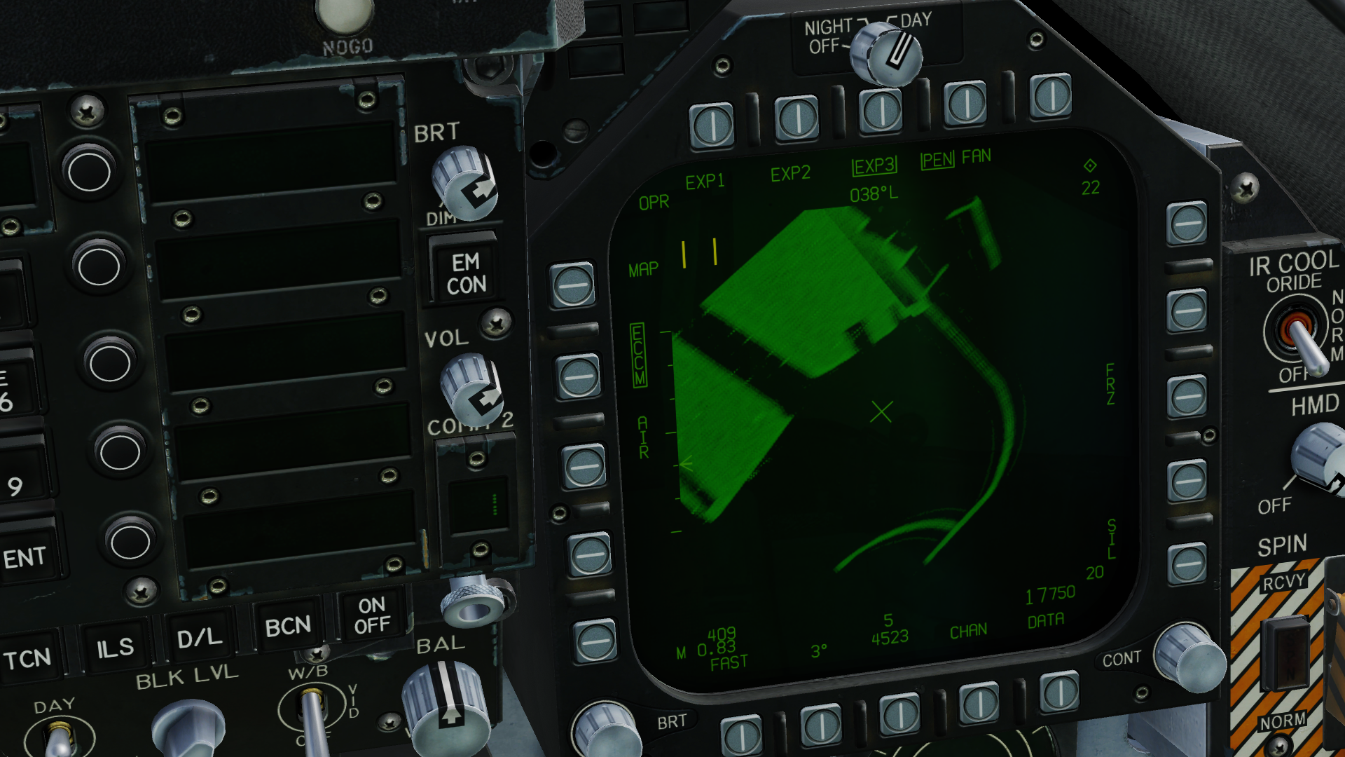
In previous Stable version, one could use the Map mode to see ships, as suggested by the briefing of "Above the clouds" (instant action - Persian Gulf). Since last OB, static ships (not added via Mission Editor) are still displayed but mission ships are only visible in Sea mode. Last stable version, ships visible in the harbour. OB 2.7.6.13133 The ships are not always at the same place, so I thought I just did not see them but they were exactly where the cross is (I used Sea mode to put the cross at the right place)
-
Hornet PG mission "Above the clouds" AIM-9L
Valtime replied to Rissala's topic in Missions and Campaigns
Just at the last minute but they are using IR R60 so in theory we shouldn’t even get a RWR tone. And as we are starting with chaff only, I struggle to defeat the migs… by the way: on previous versions I was able to detect the ships in Map mode, now (latest Beta) I can only see them in Sea mode. Has anything changed to Hornet’s A/G Radar? -
Are the Italian really calling the Typhoon the F-2000 or maybe EF-2000? I’ve never came across this name, but I’m also not living in Italy.
-
The Luftwaffe will get the PIRATE when they agree to call the aircraft by its real name A Eurofighter cannot have the full capability of the Typhoon!
-
Does IFF-ing a bandit give away your own stealthiness in any way?
Valtime replied to darkman222's topic in DCS 2.9
The IFF should work on the same frequency as civil transponder (1090MHz). But I don’t think the RWR will bother with this signals as the purpose of the RWR is to detect what kind of threat is scanning your aircraft by recognising the wave form of the received signal. For IFF, all interrogation are the same wave form, you can only distinguish between the interrogation you can answer (interrogation by a friendly) or the one your IFF transponder cannot decode (interrogation by a foe). -
I tried the server yesterday after training offline. Awesome, being able to play with the A-4 online! The mission task allocation is also really great. Of course it needs to be well prepared or one will end up attacking the wrong target, like I did… I really enjoyed it! Thanks!
-
Amazing! Is the throttle also from Open hornet? I don’t recognise the shape.
-
Hi all, since last stable update, I am missing the TTG countdown on the HUD when using the sparrow. Actually it shows for a moment at missile launch and then disappears. On the radar display the count down is still showing. BR
-
Valtime changed their profile photo
-
I think as is, it is a very good debugging tool, but even so, if you have a very long track, I don’t think it can serve its purpose due to the drifting in inputs and their results.
-
The current track replay system always reproduce the flight from the beginning and taking into account only the inputs, so that after a while all parameters seem to drift from the original events (A/C flying crashing into the see, bomb being drop not at the same location). I mean I don’t need the whole flight to be replayed. Some times I just want to see the landing, or this moment when I drop that bomb that fell 3m exactly on my target. It would be nice to be able to set when you want the replay to start, either by: - setting the event in game by pressing a button like the WW2 gun camera (which was triggered when firing), or the first stage of the trigger in the f16, or a dedicated button - selecting an event or a starting point in the debrief view.
- 33 replies
-
- 17
-

-

-
Had the same problem during serpent’s head 2 campaign (the mission you rescue the chopper crew), just like you it seemed. flying to kobuleti the distance froze at 44 NM and the TACAN station on the HSI kept moving forward as I was flying towards it...
-
Thanks @Swiftwin9s. I was using TOO for the first time and wasn’t sure that I did the handover from TGP to JDAM correctly. That’s why I was trying to compare the coordinates and was totally confuse to not see the same thing. Now I know how to do it.
-
Hi all, I’ve just noticed that the coordinate system is not the same in all pages of the hornet: - the HSI and TGP use degrees and minutes only ( xx° xx.xx’) - the JDAM and JSOW use degrees, minutes and seconds (xx° xx’ xx.xx”) also the GRID system can only be used for the HSI. This makes it very difficult to ensure the JDAM will launch and target the correct point as allocated by the TGP. is it really like this in the real hornet or did I miss an option to display other coordinate system? bonus question: by default every WP elevation is given in meters. I would expect everything to be feet by default for an american fighter...