
xxJohnxx
-
Posts
1382 -
Joined
-
Last visited
-
Days Won
4
Content Type
Profiles
Forums
Events
Posts posted by xxJohnxx
-
-
Hi Rabies,
Thanks for letting me know. I was wondering about that as well while I was watching the finished video. Seems I skipped that step! I added a comment to the video.
Best regards,
Jonathan
-
 1
1
-
-
Maybe this video can help:
-
Hi,
I'd like to share my tutorials for the Mi-24P Hind.
Part 1 - Introduction
Part 2 - Cockpit-Tour and Startup
Part 3 - Firing Shturm ATGM using Petrovitch AI
Part 4 - Firing Shturm ATGM without using Petrovitch AI
More videos to come!
Best regards,
John
-
 2
2
-
-
One thing is, all this hardware is from the time the Hind was brand new. Anywhere it's still in service, you'd have an aviation GPS mounted somewhere in the cockpit (top of the glareshield or next to the fan are good spots). Your usual Garmin box you'd have in a Cessna, with moving map and airport/navaid database.
I kinda expect that to be possible in DCS as well. I mean we already have the Garmin NS430 in the sim.
-
I totally understand that DCS is simplified version, but graphic is just unreadable especially when it comes to little airplane icon that very poorly depicted in NS430. Its hard to make sense where airplane is actually situated.
I agree. First time lookin at the DCS 430, I was a bit confused on what that symbol was actually showing. On first glance it just looks like a weird blob.
Especially with the map "north-up" it is very hard to tell which direction you are actually facing...

This is one of the pictures from the ED Shop page for the GNS 430 (https://www.digitalcombatsimulator.com/upload/iblock/ffc/Screen_170216_164755.jpg) and you can hardly make out the plane-symbol as such.
If you compare that to the picture from sdflyer, that is taken from even further away, the diffrence becomes easily noticable.
-
This problem also extends to the map display. When selecting "Track UP" the map is infact "Heading UP", which is incorrect.
-
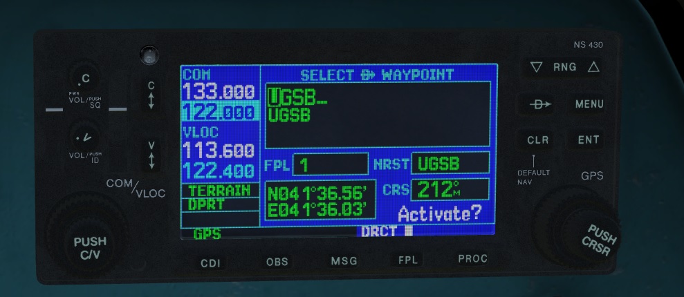
After entering a waypoint identifier and pressing ENT once, the "Activate?" prompt shows up.
Correct behaviour for the GNS 430 would be, that the "Activate?" text starts blinking until ENT is pressed.
However, in the DCS: NS 430, the "Activate?" text is not blinking, but instead the waypoint identifier entry line is blinking. See the attached picture with the "Activate?" text visible and the blinking "cursor" in the first line.
Small bug, but would be nice to see that fixed too!
-
The "Direct-To button" seems to be missing two of the key functionalities:
1)
Whenever a Airport Identifier, Waypoint or Navigation Aid (from now on called waypoint) is highlited (blinking), like for example in the NRST Page, pressign the "Direct-To button" should bring up the "Direct-To Page" with the previously highlited waypoint allready selected.
However, with the DCS: NS 430, pressing the "Direct-To button" while having any waypoint selected does bring up the "Direct-To page", however, there is no waypoint preselected. This makes the NRST page quite useless, as you still have to enter the waypoint identifiers manually.
2)
After setting a Direct-To route, bringing up the "Direct-To page" (without having any waypoint identifier selected (see point 1)) should show the current Direct-To waypoint, allowing the operator to quickly re-activate the same waypoint, plotting a new Direct-To route.
This however, is not the case in the DCS: NS 430. Bringing up the "Direct-To page" while allready flying directly to a waypoint, shows an empty Direct-To waypoint, forcing you to re-enter the same waypoint you are allready heading too.
This functionality is immensely useful while flying VFR and only using the NS as a loose direction reference and is desinged like that in every Garmin navigation system.
-
The "NRST Airport" page should list 9 airports, showing 3 at a time in a scrollable list. However, while the scrollbar is visible, it is not possible to scroll down to entries 4-9.
The other NRST pages (NDBs, WPTs, VORs) scroll just fine.
-
Found a small issue with the NS 430:
On the NAV Page 1, the TRK indicator actually shows heading instead of track. The NS 430 can not know the current heading of the helicopter because it lacks a compass. Track however is calculated by GPS position and is independed of helicopter orientation.
Easily reproducable by flying forward and adding some rudder. Or by flying the helicopter in reverse.
-
Haha, nice! Thanks for sharing!
I heard about "Runway 34", but I didn't know about the Heligrill.
Will check it out once I move to Zurich!
Best regards,
John
-
Welcome to DCS and the forums and thanks for the kind words!
There is one problem in mission RB04: i cant see any radar contacts, and when i have opend it in the editor, there ist no target at waypoint 3 ??
something wrong with me or the mission?
In order to preserve an element of surprise, a mission designer may choose to hide some units [...]Indeed, to make this mission a bit more challenging (so that one has actually use the radar :smilewink:) I have hidden the units in the mission editor.
As Rudel mentioned, you can turn them back visible if you want to.
If your radar screen is illumiated, do you actually see the sweep going across? If not make sure that you are in the proper A1 radar mode.
In mode A0, the radar will be off and in mode A2 the radar will show a magnified B-Scope (zommed square representation instead of the arc) that is positioned arround the current target point.
Best regards,
John
-
As a followup to the previous video, in todays tutorial we are taking a look on how QNH, QFE and the radar altimeter work for targeting in the Viggen.
Using QNH, QFE and the radar altimeter:
Mission:Download
Enjoy! :thumbup:
-
1
-
-
One think that I do not understand, if I want see and move the cross on the radar I must press "T1", but for display this famous cross the circle or waypoint must be right ahead me, if I fly over the circle and if I want display the cross it's impossible because the circle or waypoint is now behind me and the cross is also behind me.
Please can you tell me if the waypoint or circle is behind me how I can display the cross for lock one target (boat) front me ?
There must be some better way but what worked for me is to keep the slew up button until the cross comes back on the screen.I would assume that this is not intended behaviour.
It makes sense for doing a navigation update (on a B waypoint) where the new position is close to the waypoint.
However, as you have experienced, this is quit annyoing when trying to desingate a target (especially BX waypoints that have not been set yet). Often the cursor appears somewhere off-screen and you have to guess in which direction to slew it so that it re-appears on the radar screen.
I have seen this mentioned multiple times (also mentioned it here and there myselfe), however so far I am not sure if this is intended or indeed a bug.
Maybe someone able to read the Swedish manuals (@renhanxue or someone else?) is able to shed some light on the real behaviour.
-
Hi John,
First of all congratulations, your tutorials are well prepared, easy to understand and very useful.
While i was checking viggen's videos on youtube it appears that someone is stealing your work...
I already reported it, i just wanted to let you know.
And i'm not sure if i can post a link there but you'll find it easily by filtering with last date.
Thank you for the information. Could you provide a link?
-
So the process of a manual "fix" then would be to press and release your T1 button, then press and release your "TV" button when over your marker, then press "T0" to put it back to default?
Yes.
If you have a 3 position switch it is a bit easier. You can have it set up that in the forward position it is in T0, in the middle it is in T1 and pulled back it is in TV. This is the closest that you will get to the functionality without using an actual 3 position trigger.
-
-
This turn is due to the BX 7 Waypoint. if you put in the BX8, you will see on your scope, that a X is on the right side of your plane(45-60 Degrees)
You have to manually select Bx 7 and put it in front of you, so the missles wont turn away from the direct path to the target.
I think he is refering to a bug that caused a 90° at Bx7. This was/is happening when you use code 800002 for example. Has been happening since release.
-
1 millibar is also about 8 meters of elevation. If QNH is 1000 and your target is at an elevation of 80 meters, target QFE is then 990.
While this is true in the real world in standard conditions (1 hPa = 8.3m) I found that there seems to be a diffrent pressure per meter change in DCS. Some testing I did showed that for a point at 2000m above sea level, the ratio seems to be more like: 1hPa =9.3m.
Wondering why that is the case. Maybe a DCS quirk?
-
Thank you all for your kind words! Very appriciated! :thumbup:
Just got arround to finish another video I was wanting to do for some time now:
Ingame Flight Planning
This video shows on how to use the ingame F-10 map for planning a flight without the use of the mission editor.
Enjoy! :pilotfly:
-
The basics:
More advanced stuff:
-
Hey John, do you have CCIP tutorial? For some reason I'm coming up short. Story of my life. :)
I wanted to videos about the bombing stuff, however, I caught the flu and spent majority of the last couple days in bed. Once fully recovered I will get back to the tutorials:pilotfly:
-
Looks great!
-
Will apparently ship during February!

Transition from free flying to ground effect is quite violent.
in DCS: Mi-24P Hind
Posted
In my opinion the yaw spins are not caused by the autopilot but rather by being overloaded.
If you have a full weapons load and full fuel you are overweight and the helicopter still flies, but the tail rotor has too little authority to overcome the yaw produced by the main rotor at high blade angles required for hover.
During forward flight both the lower blade angle and the aerodynamic stability of the tail cause reduced tail rotor load, and therefore it can fly even when overweight. However, as soon as speed is reduced, yaw becomes uncontrollable.