Tinman
-
Posts
62 -
Joined
-
Last visited
Content Type
Profiles
Forums
Events
Everything posted by Tinman
-
When asked about revamping older ED maps to current standards on a recent Mover & Gonky show on YouTube, Wags said they "may do it" and NTTR was the first map he mentioned as being talked about internally. The map-developers are currently busy with Marianas WWII, Iraq and Afghanistan maps, though. So it may be a while until they actually do it. However, no details were given if that may or may not include expansions of the map area or improvements to currently low detail areas of the map.
-
Also an interesting remark of Wags in that Interview: ED has no plans for a tilt rotor module (like an Osprey), but he heavily implied that a 3rd Party might at some point. ("We are not doing it, but I'll leave it at that.", approx. at 1:32:47 in the video) And I'm pretty sure that regarding the Mig-29 Flight model question Wags was saying that all currently flyable Flaming Cliffs 3-Versions of the Mig-29 are all using basically the same flight model. Nothing was said about the flight model of the upcoming full fidelity Mig-29 (approx. at 1:34:17 in the video)
-
A neues Gwand für die Dora! - Hi Res Textures for the Dora
Tinman replied to Doughguy's topic in DCS: Fw 190 D-9 Dora
Wow! Just wow. Kudos to you. Not only for the result (these screenshots do look amazing) but also for putting in the effort researching all this and making the skins not only pretty but also authentic. -
You really know how to make compelling Screenshots. Each and every one is a banger! The front turret is coming along nicely.
-
What a beauty!
-
At the southern end of the suez-canal there is a group of Helipads in Grid VT38 that are duplicate, slightly offset and intersecting each other: Camera Coordinates: -camera -37.586696 0.040190 102.177882 -cameradir -0.247817 -0.423329 -0.871424

-
Follow-up: Happy to report this is fixed in 2.8.6.41066: Now there will be no more dispute if the ball was across the line or only across that other line
-
@winghunter Who is making a "South East Asia" map? Did I miss an announcement?
-
A neues Gwand für die Dora! - Hi Res Textures for the Dora
Tinman replied to Doughguy's topic in DCS: Fw 190 D-9 Dora
They look gorgeous. The Dora almost feels like a new plane with these. -
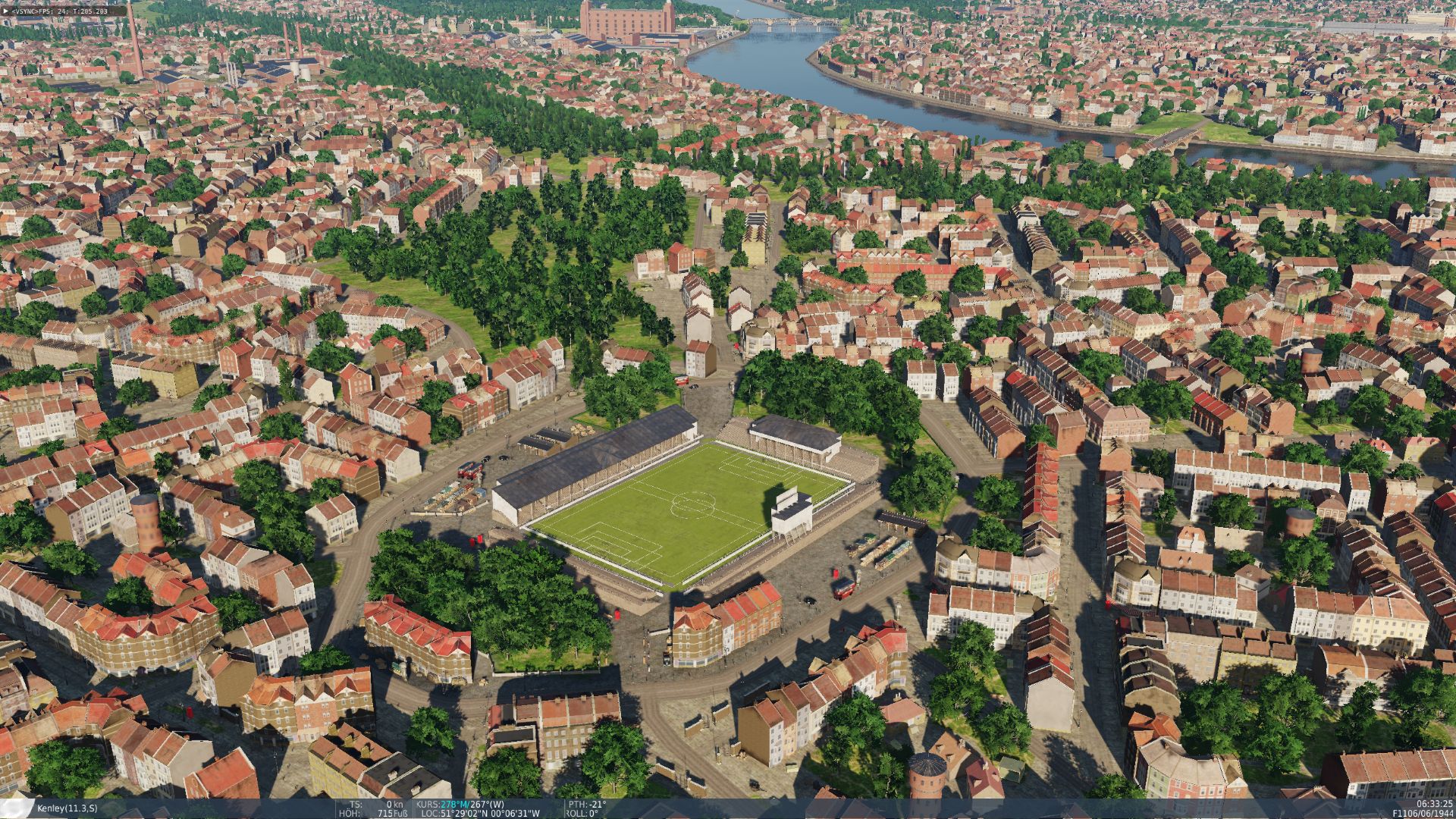
I know them Brits love their football, but one pitch should be enough : Just something I stumbled across while exploring the new areas. Lat/Long can be seen in the picture, Camera coordinates are: -camera 222.812042 0.120744 5.071210 -cameradir -0.069493 -0.378960 -0.922800
-
@Sluggish Controls Night Lighting will be on or off depending on the mission date:
-
already requested Restrict Civi Traffic in ME
Tinman replied to GazAce's topic in DCS Core Wish List
Do you have an example of how to do it? On the Syria-map at least they do have a collision model. I was enthusiastically creating road bases only to be run over by vans and cars. Without civilian traffic the map feels unnaturally empty. Any means to restrict traffic locally would be highly appreciated. Ideally the cars should react to (static) units blocking the road and just turn around, but any crude despawning or hiding when a trigger zone is entered could be worked with as well. With all the airframes we have that are roadbase-capable this really should be a thing. The immersion-breaking when ghost cars pass through roadblocks, checkpoints and ground units as mentioned before restricts mission builders as well. I posted a similar wish a while ago and I certainly was not the first to do so either. Let's hope the devs take notice someday and implement it. -
What a nice and simple rectangular box. Would be a real shame if someone carved out a certain bit of it and turned it into an L-shape, wouldn't it *wink-wink-nudge-nudge* /s
-
Probably a step in the ground, as it was the case at incirlik.
-
Great Stuff! Thank you for doing this. I'm sure they will be great missions. I bought the Dora during its Beta-Phase back in 2014, so I got a little excited by the thumbnail to finally have some high quality content for it. Only problem is I was never willing to buy the new and shiny Anton with the Dora essentially abandoned and forgotten by ED collecting dust in the DCS main menu. I never bought the channel map as well, I already had the normandy-map. Sure it looks better but it being so close to an exisiting map and being so small I could never justify the purchase. So I consequently also don't have the Horrido-campaign and yet again the Dora remains grounded.
-
reported earlier Kneeboard folder for Syria map PLS
Tinman replied to 303_Vins's topic in DCS: Syria Map
We can only speculate what the is actually needed for the fix, but here from the outside it appears to really be only the line in the encrypted cfg-file of the map telling DCS where to look for the kneeboard pages. I cannot imagine any system or mechanism more than that is involved (on UGRA's side) to make it work, as it works flawlessly on other maps and is a core DCS feature. We're not talking about any modification of the geometry or textures here. In that case it should be easy enough for them to grab the config-file of the version publically available now from their repo, add the line and encrypt it. Then put that in the user files, add a disclaimer to use at your own risk and done. People who care can use it, people who don't lose nothing. In the next update (whenever that may be) include the proper fix (which allegedly already exists internally). I'm all for being patient, but at some point there is just nothing left to "muster up". -
Well, Normandy 1 is already roughly that size. If you open it in the mission editor right now and zoom out all the way you pretty much see the same map as the one in this threads first post (minus the new airfields and all the the colorful boxes and L-shapes of course). Most of the area is just barely detailed when you actually fly there. More info from UGRA or @MAESTR0 is always welcome, and it certainly has been a pleasant change from their usual total radio silence, but most of the info is already in the same post you already quoted an excerpt from and the first post: Again, we can only guess how well (or even if) this whole compatibility-business will work until it is actually released. Funnily enough, the screenshots below the bit of text you quoted earlier ("All obstacles and terrain for both maps will be the same after updates") has several examples in it where the two differ wildly (Rows of trees vs. no trees next to the roads in the top left part of the image, four tiny buildings vs. 2 large ones just left of center of the image and the buildings on the right side of the runway to name a few).
-
Not core, but Normandy v1. Normandy 2 is a completely new map and Normandy v1 will apparently get updated as well to make both terrains similar-ish (elevation data and rough obstacle-placement). How well this will work eventually remains to be seen, but that seems to be the idea.
-
Unfortunately, that is a thought that popped up in my mind quite often since the announcement. While feeling mostly positive and excited about the new map, there seems to always be at least one odd curveball when new details arise. After the initial announcement I thought it would maybe not eliminate, but at least reduce the fragmentation of the DCS WWII experience a bit. Instead, this seems to make it even worse by adding yet another layer of duplication and artificial separation. At least before you could make the excuse for the channel map's existence that it was merely somewhat close to another map. Excluding just this area now with almost surgical precision feels increasingly ridiculous to me and, again, doesn't make a ton of sense.
-
Impressive details already and even better presentation. Those renders look absolutely stunning! I love the one from the front with the ominous shadows. I always cheer up when there is an update notification for this thread.
-
I'm working on a quick reference document with all sorts of information I'm likely to forget to quickly remind me in the air after longer DCS pauses. I already added the pilot's reticle and would like to have a similar diagram for the copilot side. I'm using the sights more or less by intuition only and doing alright there, I'd say. I usually only fly in the right seat also, but for the sake of completion I'd prefer to have this information in there, should I need it. Having that information for one but not the other triggers my OCD for some reason .
-
Depicted in the flight manual is a handy little diagram of the pilot's sight reticle with the corresponding 'mil'-values (fig. 8.8 on p. 102 in english version). However no such information is given for the sight of the copilot. Do the circle-diameters there translate to any particular 'mil'-value like on the right seat? They visually seem to be of different sizes.
-
Beautiful!
-
closed Storm of War - DCS WWII / Historical Server
Tinman replied to philstyle's topic in Multiplayer
Thank you Phil and everyone who helped to make Storm of War such a special server. Sad to see it vanish so suddenly. -
Looks like the one by upuaut: called "FBI with Markings" under the United States section. Edit: seems the Dropbox link is dead. The one from his QNAP cloud in the first post seems to be working: https://www.myqnapcloud.com/share/7397jijk7p84o29sw9yx29yd_12hfjk5hn8392684rv2x76x3ba92075h#/home/DCS/DCS_Skins/uh-1h

_2023_06.11-19_32.jpg.fcbbe6ae9d7989d6006407a8befafb05.jpg)
_2023_06.11-19_29.jpg.add3b78a56eb69af35c55dc7e015e91e.jpg)