birkenmoped
-
Posts
137 -
Joined
-
Last visited
Content Type
Profiles
Forums
Events
Everything posted by birkenmoped
-
 Hi, during further "research" I found the following illustration/map: Picture description says: British map of the German radio measuring positions (Channel and Normandy), status: 20 days before the invasion. * = unrecognized positions. If I see it correctly, then a mammoth is registered for Fecamp... 20 days before D-Day Source/Quelle: Die deutschen Funkmeßverfahren bis 1945 - Fritz Trenkle
-
@Night Owl Hi Night Owl! No, I couldn't find any really clear sources. The German Wikipedia entry on Cape Fagnet (https://de.wikipedia.org/wiki/Kap_Fagnet) goes in the same direction as the English entry, but it also mentions a possible reason why the Mammoth may not have been built and/or used...! [...] Bunkers In 1942, in anticipation of an Allied invasion, the Cape was fortified by the German occupying forces with bunkers as part of the Atlantic Wall. The control center of the Würzburg radar station and several smaller bunkers can be found on the cape today. three large concrete pedestals, which were used for a 300 km radar system of the Mammut type radar system. However, this was never put into operation, as German troops had to withdraw in August 1944. [...] However, many websites dealing with the Atlantic Wall (https://www.atlantikwall-frankreich.de/2_aok_15/kva_f/1_fecamp/fe_08/fe_08.html , https://www.gyges.dk/FuMO locations and types Channel ver 5.pdf , https://www.geschichtsspuren.de/forum/viewtopic.php?p=59663&hilit=fecamp#p59663 ) list various radio measuring and locating devices under "AOK 15 - KVA F - KVGr Fecamp - Fe 08", e.g. Würzburg Riese, Freya and also a Mammut V143 device.
-
I don't know if I understand the last statement regarding Fecamp, maybe something is lost in translation? In Fecamp there is only ONE foundation for ONE mammoth in the naval variant (FMO51/52). Especially since, according to Wikepedia, only the foundation was there (presumably until the end of the war), but without the radar. The naval variant has "only" three masts, as already mentioned. Concrete emplacement built at Cap Fagnet, Fécamp, Normandy, where the Mammut was never erected - Wikipedia/Wikimedia Source: https://en.wikipedia.org/wiki/Mammut_radar - https://commons.wikimedia.org/wiki/File:Blockhaus_Fécamp_(2)_0017.JPG FMO51/52 „Seetakt“, Kriegsmarine-Ausführung mit drei Masten / FMO51/52 "Seetakt", Kriegsmarine version with three masts - Wikipedia/Wikimedia Source: https://de.wikipedia.org/wiki/Mammut_(Radar) - https://commons.wikimedia.org/wiki/File:Mammut_Small_hoarding_radar_illustration.png The Wijk aan Zee Mammut antenna standing on top of a V 143 type bunker. This bunker concept was especially dedicated to facilitate naval (KM) Mammut systems - Courtesy David & Vincent Kossen Source: https://www.cdvandt.org/mammut-wassermann-part2.htm The Luftwaffe variant (FuMG-41/42) with four masts, as in the new DCS model, should have stood in the "Normandy 2.0" map area only at the above mentioned positions (FuMG). FuMG-41/42 „Mammut“, Luftwaffenausführung mit vier Masten / FuMG-41/42 "Mammut", Luftwaffe version with four masts - Wikipedia/Wikimedia Source: https://de.wikipedia.org/wiki/Mammut_(Radar) / https://commons.wikimedia.org/wiki/File:Mammut_Hoarding_radar_illustration.png Antenne des Mammut-Gerätes / Antenna of the Mammut device - Christian Wolff Source: https://www.radartutorial.eu/19.kartei/11.ancient/karte002.de.html Greetings birkenmoped
-
For informations (.kmz-files for Google Earth) about V1 you could use: https://www.relikte.info/v1.html check also the "Atlatikwall - France" - section and/or the "more" - section for: German radar positions to monitor air activity over Europe to lead interceptors to their targets. German radar positions to monitor ship activity. German infrastructure to guide interceptor airplanes with the Y-Verfahren (Jagd). German infrastructure to guide airplanes.
-
Snippets from map: https://www.nonstopsystems.com/radio/pdf-hell/map-Flugmldeeinstz-OrgPlngn.pdf Ref. 210W: "Flugmeldeeinsatz- und Organisationsplanung", Zeichgs-Nr. 44/20-1-A, GKdos, OKL. Gen.-Nafü, 1. Abt. III. Map is dated 20 June 1944. [file size: 63 MB; good-but-lower-resolution file is here, 26 MB]. Source: BArch-MA/BAMA file nr. (Signatur) RL 2-V/9. Note: this map has the same background map as ref. 210V, but with some different mark-ups. Map covers area of northern Britain to northwestern Egypt. Map is marked with locations of Wassermann (L/M/S), Fu.MG (nachtjagdfähig), Mammut, Freya (+ An , + An & Gemse, + An & Kuh, + Kuh & Gemse, + Fahrstuhl), Würzburg (A-D, Riese, Riese + Gema Zusatz), and also boundaries of Zusatzzahlgebiete, Jagdtrapezbegrenzung. Map size: 6x5 (WxH) A4-sheets. Map scale 1:2500000. Source: https://www.nonstopsystems.com/radio/hellschreiber-modes-other-hell-RadNav.htm#top-of-page
-
I too was happy about the Mammut model, but it would indeed be nice if the placement would at least be correct. How about a free placement model? In addition, I would like to note that I have not found any Mammut positions where three pieces stood next to each other?! But Night Owl... I can't find any information about a "MAMMUT" in Douvres? On the photo that tigayot228 had uploaded (the long shadow is of an Wassermann S) and the site plans of Spuks there was only one Wassermann S, Freya and 2 Würzburg Riesen on this site. Check also: http://www.atlantikwall-frankreich.de/3_aok_7/kva_h/kvgr_caen/kvugr_riva_bella/stp_douvres/stp_douvres.html Auf diesem weitläufigen Gelände das sich aus den zwei Stellungen Distelfink I und II zusammen setzt waren neben dem heute dort ausgestellten Würzburg Gerät auch ein Wassermanngerät, sowie zwei Freye Geräte vertreten. Heute ist nur ein kleiner Teil des Areals zu besichtigen. Darunter der Jägerleitstand, ein Luftwaffenregelbau des Typs L 479. Nicht zugänglich hingegen ist der Unterstand für Ortsfeste Funkmessgeräte ein Luftwaffenregelbau des Typs L 486 sowie der Bunker des Wassermanngerätes, ein L 480 (Luftwaffenregelbau) Translation: On this extensive area, which consists of the two positions Distelfink I and II, there were also a Wassermanngerät and two Freya devices in addition to the Würzburg device exhibited there today. Today only a small part of the area can be visited. Among them is the fighter control post, a Luftwaffe control post of type L 479. Not accessible, however, is the shelter for fixed radio measuring equipment, a Luftwaffe control post of type L 486, as well as the bunker of the Wassermanngerät, a L 480 (Luftwaffe control post). But I found these Mammut positions, which were in the map area (see table below). Whereas our model (with 4 vertical struts) would have to be an "Luftwaffe Mammut" and thus only the FuMG designated positions (table) would come into question. Abschnitt AOK 15 / KVA C FuMO Stp 265 Lungenkraut (Le Nocquet/Equihen) FuMO 51 Mammut-Gustav MKB Stp 164a Sickingen (La Dreve) FuMO 51 Mammut-Gustav FuMG "Wels" Stp 178 Kellergeist (Mt. Plouvin) FMG 41 G (cF) Mammut Caesar (Lw) Abschnitt AOK 15 / KVA E2 FuMG "Dickhäuter" Die 010 (Dieppe) FMG 41 G (cB) Mammut F Abschnitt AOK 15 / KVA F FuMO Fe 08 (Fecamp) FuMO 52 Mammut Caesar Abschnitt AOK 7 / KVA J2 FuMO WN 345 HagueII (Hameau des Asselins) FuMO 52 Mammut Cäsar FuMG "Ammer" WN 364 (Jobourg) FMG 41 G (cF) Mammut Caesar oder Mammut (cB) Friedrich FuMG "Pferd" Pferd (Predefin) FMG 41 G (cB) Mammut F Sources: http://www.atlantikwall.info/radar/france/rf_.htm https://www.relikte.info/ and http://www.atlantikwall-frankreich.de
-
How many Normandy 2.0 Airfields used The Lorenz System in WWII
birkenmoped replied to DishDoggie's topic in DCS: Normandy 2.0
Luftwaffe Airfields 1935-45 France (with Corsica and Channel Islands) By Henry L. deZeng IV https://www.ww2.dk/Airfields - France.pdf for e.g. Évreux-Fauville (FR) (a.k.a. Évreux/Ost) (49 01 30 N – 01 13 20 E) General: airfield in Normandy 80 km W of Paris, 5.6 km E of Évreux, 2.25 km E of Le Coudray and 1.5 km ESE of Fauville. History: dates from the 1920s when it was first used for sport flying. A French Air Force base for Dewoitine fighters, Potez bombers and American- made aircraft duing the 1939 to 22 Jun 40 period. Extensively developed by the Lw. from late June 1940, Evreux-Fauville quickly became one of its principal bomber bases in northern France and remained so until 1944. Dimensions: approx. 1830 x 1370 meters (2,000 x 1,500 yards). Surface and Runways: two concrete runways with concrete assembly hardstands built in the 1930s and laid out in the form of an “X” - (1) approx. 1645 meters (1800 yards) aligned NE/SW, and (2) approx. 1600 meters (1750 yards) aligned E/W. Otherwise, level grass on clay subsoil. Extensive taxiways to dispersal areas. Both runways equipped with night landing capability (permanent illumination and flare-paths, visual Lorenz system, beam approach system). -
How many Normandy 2.0 Airfields used The Lorenz System in WWII
birkenmoped replied to DishDoggie's topic in DCS: Normandy 2.0
-
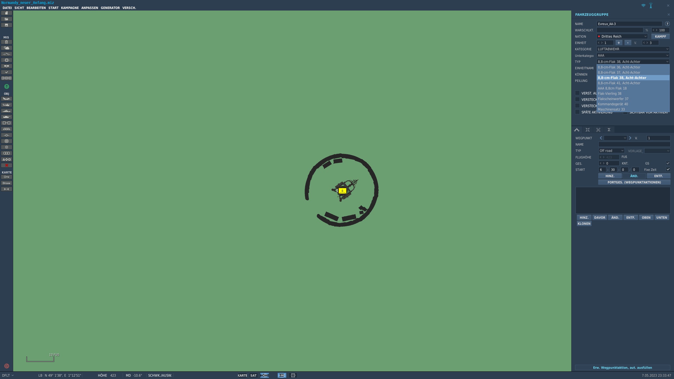
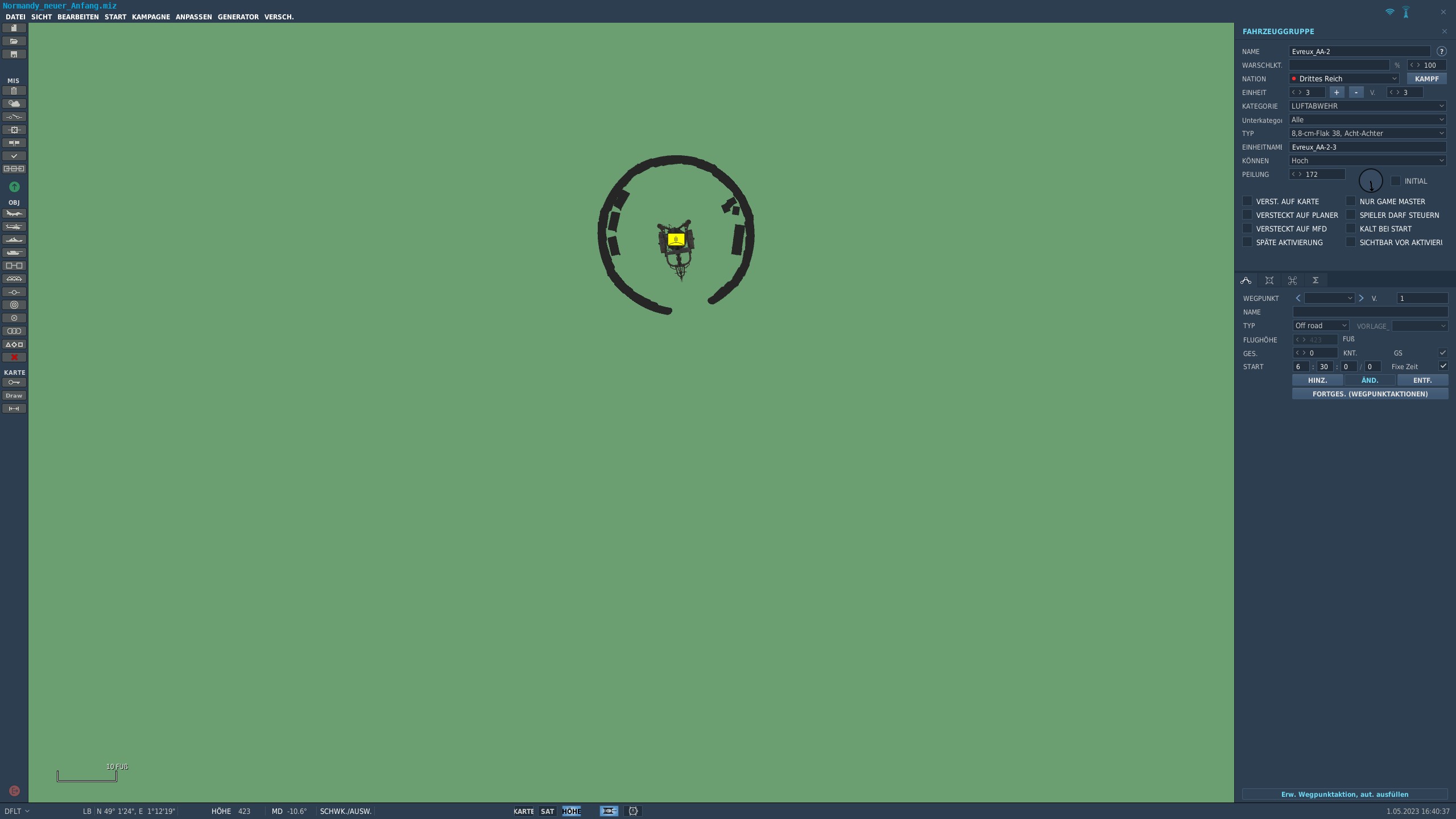
Guten Abend, irgendwie ist (zumindest in meiner Installation) bei den deutschen Bezeichnungen im WWII Assets Pack im Bereich AAA was durcheinander: Die 2cm Flak 30 taucht bei mir im Editor unter "8,8-cm-Flak 38, Acht-Achter" auf, kann das Jemand bestätigen? Von den Acht-Achter sollte es es ja die 18, 36, 37 und 41 geben (das passt auch irgendwie, auch wenn die Schreibweisen (siehe auch Screenshot) nicht wirklich einheitlich sind) und die 2 cm Flak 30 und 38 (Flak-Vierling)... Gruß birke
-
On this MP server the missions rotate every 3 hours between clear weather, rain and night. Could possibly be a weather/wind setting that the ATC doesn't like.... But I'm not sure if this always happens, because after so many times I've had this ATC miscommunication, I just ignore it by now.
-
Kutaisi while sitting in a Harrier. Ask for takeoff, got clearance, roll on runway, got „unable to…“, while takeoff run got clearance again.
-
However, I have also had this behavior from ATC in multiplayer e.g. on servers with the Georgia map. So maybe it's just an ATC problem and not a map specific one.
-
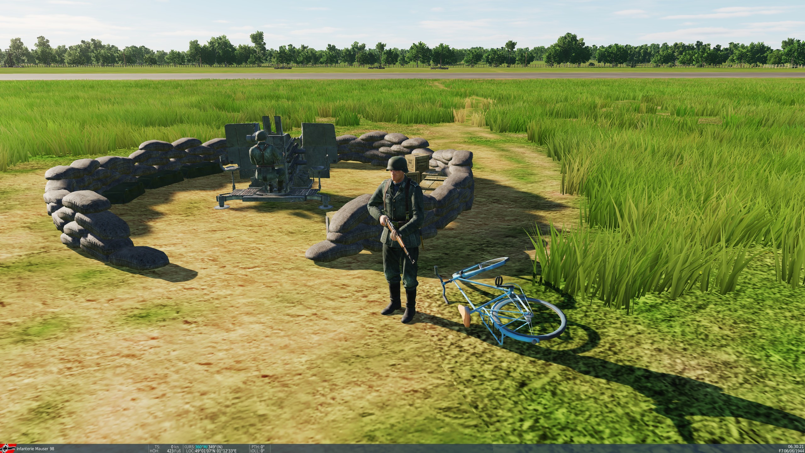
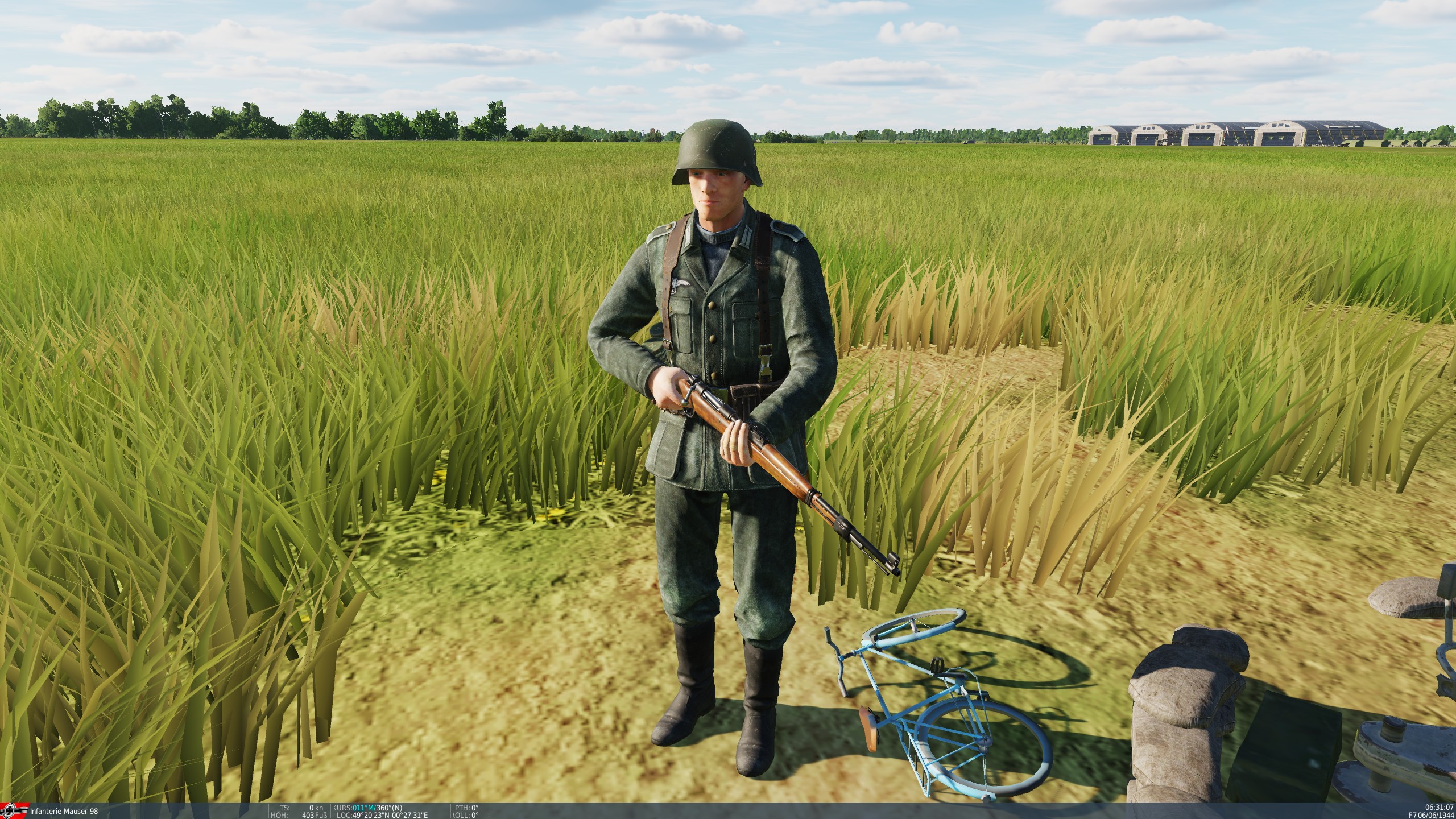
Hi! Screen1.jpg shows the position in the right size, also the bike lying on the ground looks good from the proportions. Screen2.jpg and Screen3.jpg show the partly strongly reduced positions (sandbag wall is clearly lower and the diameter of the position is also clearly smaller than the original in Screen1.jpg. The corresponding bike is now more suitable for kindergarten children or a clown show. I could find these "shrunken" emplacements on the following airfields so far: Vrigny, Argentan, Broglie, Triqueville, Essay, Hauterive and Orly.
-
investigating Wrong scale of churches and factory chimneys?
birkenmoped replied to lwalter's topic in Bugs & Problems
What does too long mean? Perhaps only a little more variety is missing there? -
Saved Games\DCS(.openbeta)\Sounds
-
[FIXED] Part of HUD always at full brightness
birkenmoped replied to arneh's topic in Problems and Bugs
Same issue here. Also some MFD infos are at full brightness see screenshot. The floodlights are also not working on my side. (Screenshots was after full repair and without any mods etc.)
-
Hallo @Bananabrai versuch mal bitte folgendes: https://forum.dcs.world/topic/199518-reportedso-the-ab-212lodsjson-huey-skins-too-shiny/ Wäre natürlich schön, wenn ED das nach über 2 Jahren mal fixen würde!
-
reported Roland acquisition time is way too long
birkenmoped replied to Rissala's topic in Bugs and Problems
Establish combat readiness Betriebszustand (Operating state) Beschreibung (Description) Zeit (Time) 1. Grundzustand (basic state) Turm, Richteinheit und Antennen in Ruhestellung verriegelt. Stromversorgung aus (Turret, pointing unit and antennas locked in rest position. Power supply off) 3 min 2. Überwachung (surveillance) Stromversorgung ein, Suchradar aufgeklappt und in Betrieb. (Power supply on, search radar unfolded and in operation.) 15 s 3. Bereitschaft (readiness) Ladearme in 90°-Position, FR-Antenne aufgeklappt und verriegelt, Hydraulikdruck Wanne aufgebaut (Loading arms in 90° position, FR antenna unfolded and locked, hydraulic pressure hull built up) 16 s 4. Bekämpfung (engagement) wie 3, zusätzlich Visierklappe des optischen Visiers geöffnet, Turm und Richtanlage sind entriegelt. (like 3, additionally sighting flap of optical sighting open, turret and aiming system are unlocked.) 2 s Source: https://dewiki.de/Lexikon/Roland_(Waffensystem) Source: http://www.flarakgrp42.de/technik/rolandfrr/betriebsarten.php Bekämpfungsablauf (combat sequence) http://www.flarakgrp42.de/images/roland-technik049_lbb.jpg From right to left (see also arrow) 9 seconds to launch - Search 7 seconds to launch - Assign 5 seconds to launch - Target Lock 3 seconds to launch - Track 1 second to launch - Engage (triggered by commander) 0 second - Launching the missile Source: http://www.flarakgrp42.de/technik/photogaleriefrr/technik-frr--allgemein.html -
+1
-
Maybe the "responsible persons" should think about what a new buyer, who has been waiting all the time for the module to finally be released from early access, should think about after the release? "That is your choice to make as a consumer, if you have doubts about early access it is always best to wait" to quote BN. This is exactly the buyer who has saved himself the whole Early Access stuff and now rightly expects a feature complete module. Whether the new buyer understands that a module declared as finished by the manufacturer may have so many errors and shortcomings? Is it possible to justify that the module is finished but the manufacturer is still working on it? On which contractual basis should he rely, if the module is already sold as feature complete? For customers who tried to support the manufacturer by purchasing the Early Access module and reporting bugs, it is of course not easy if their reports simply fade away "unheard" and the module is then delivered with the bugs known to the manufacturer as complete, finished and/or feature complete. But this has already been sufficiently discussed.
-
I'd vote no if I could. I don't like fictional liveries at all.
-
[OLD BUG REPORTS] Cleaning and Organization of old posts
birkenmoped replied to RAZBAM_ELMO's topic in Resolved Bugs
As a small reminder... This problem still exist on OB 2.5.5.35461 (since 01-16-2019) -
Does the name change anything that a problem or error exists and has still not been fixed? An error that I can "see" at any time weighs in my opinion just as much in daily use as errors of a more hidden nature, such as the problem with the jumping out fuses. So the machine stays in the hangar for now. That is and remains just the danger with early access.
-
-
So... what did we get today (06.21.19)
birkenmoped replied to MadCat1381's topic in DCS: Fw 190 A-8 Anton
This one looks also fixed: https://forums.eagle.ru/showthread.php?t=242592