Mayo2017
-
Posts
61 -
Joined
-
Last visited
-
Chiming in with the same troubles. Drop on start with damage and gear extension following, unable to rearm/refuel, all of it. Wiped all configs such, removed all mods, ran a repair, installed VC++ as required, no luck.
-

** DCS: AJS-37 WIP Pre-Release Manual Released! **
Mayo2017 replied to Cobra847's topic in DCS: AJS37 Viggen
Pages 22 and 23: Numbers from about #40-46 in the list point to the incorrect object on the cockpit diagram. -
Bah, if you're trimming the tips of the grass with your air intakes, that just means you still have room to go lower. :music_whistling:
-
-
TrackIR Behavior with 1.5.4 Release
Mayo2017 replied to Flame's topic in Release Version Bugs and Problems (Read only)
It doesn't help that (not sure about 1.5.4) what TrackIR says it's sending to DCS, and what DCS actually shows are different. For example, TrackIR will say that in-game I'm looking 60° to the right, but in DCS I'm actually looking 90° to the right. For me, things like E:D and FSX do exactly what TrackIR says it's doing, while DCS does not. -
Could it also be the pitch/bank autopilot trying to pull the nose back up?
-
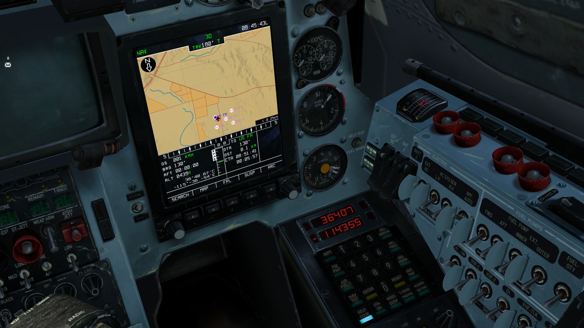
Yes. When entering coordinates in the PVI-800, precede positive coordinates with the 0/+ key, and negative coordinates with the 1/- key, negative coordinates being south and west. Currently, do not use coordinates taken from the ABRIS if you're in Nevada, since the longitude data is incorrect and will lead to bad waypoints. The coordinates shown on the ABRIS in Nevada are approximately 91km west of your actual position. See the map I added to the first post to help visualise the issue.
-
In Nevada, when programming waypoints into the PVI-800 for the first time in ages. Using the ABRIS to get coordinates for my waypoints, I input them in to the PVI-800 only to find that I was being told that I was some tens of kilometres off of my actual position. Cross-referencing my current coordinates as listed on the ABRIS, the PVI-800 SELF COORD and INIT POS, the F10 map, and my actual position on Google Earth, only the ABRIS was incorrect, consistently telling me I was about 1°1' west of my actual position. Issue is present across missions, both singleplayer and multiplayer. Issue is present in Nevada, is NOT present in the Caucasus. Edit: Attached map visualisation.

-
I've been using the limited ground attack capabilites of the Su-27 as a way to scratch that itch. Poorly-implemented as it is, using it like a Viggen is a surefire way to really piss some bad guys off when they aren't expecting something to come in at mach 1 at 20m AGL, dump rockets, and burn away. :lol:
-
This. It's already hurting squadrons that want to use new maps, but a few members can't justify spending the money.
-
Every second spent aiming is a second every unit beneath you spends aiming back at you.
-
Especially baffling when they've got a whole new engine to work with.
-
Hmm.... AS565 would sure be something.
-
Sorry, I meant to say "SPAK mode", I'd been awake for like 30 hours at the time. :D
-
Thanks for the explanations of the SA system! It was really bugging me not understanding what SPAK did, and it's great to know what the logic of the other modes is.