mafuasu
-
Posts
110 -
Joined
-
Last visited
Content Type
Profiles
Forums
Events
Everything posted by mafuasu
-
try to deliver the boms with mach .7 and not over 50 meter AGL. this is the natural behaviour for the viggen and the use of CCIP. this aircraft ist designed to fly low and fast. and the high drag boms detonate when you are gone away. btw, the time line is not necessary. stay in NAV mode, pull trigger once for unsafe and aim the target between the greater and the smaller circle. if it reach the greater circle pull and hold the trigger to release the boms.
-

[FIXED] How do you get unlimited ammo to work ?
mafuasu replied to AdurianJ's topic in Bugs and Problems
create a mission with in air start 30km away from the target area. Give the waypoint a time cause it will be an attack point then without have to enter 9 in TAKT and press B1, B2 or any other. then you can test very quick. with shift+R you can quickstart the mission. -
** AJS-37 Changelog / Update Master List **
mafuasu replied to Cobra847's topic in DCS: AJS37 Viggen
Guys its a prerelease. And most ist internal updated. Its not to heatblur to decide wich will be going public and when the patches from ED will give to us. Mostly of the Viggen works cery well and its a beautiful simulation of a very lovely aircraft. -
Question about the order for enter coordinates...
mafuasu replied to Skulleader's topic in DCS: AJS37 Viggen
You put only 14 instead 114 as the first to digits. The rest as describe above. -
Works fine. Also the app for iPhone. QNH from the kneeboard and height from the F10 map and then bombs away ;)
-
Try to engange the Land/Nav mode more far away from L1. The waypoint the HUD guide you for is the LB1 Waypoint wich ist 20km away from the Airfield on a circle depending on the side of the runway you are by activating the Land/Nav mode. Look in the manual at page 143. there and before is a good explaining for this. When you want to engage the Land/Nav mode not so far away aprox 15-20km, then choose the LAND/PO and switch back to LAND/NAV and the TILS should working. Then you get waypoint LF1 wich is 10km away from runway treshold and ist also equal to the descent point. Sorry for my bad english. Mafu
-
Das stimmt... wusste nicht das die soo klein sind.
-
Statt Anreibebuchstaben einzeln zu kaufen könnt ihr auch bei einem Werbetechniker mal fragen was er für Folienplott haben möchte. Vorteil ist, das die Texte/Wörter schon in richtiger Größe und Satz auf einer Übertragungsfolie sind. Muss man zwar auch anreiben aber komplett in eins. Kostet bestimmt nur irgendwas um 60-80€. Und die Texte setzt ihr vorher ganz normal in einem Programm wie z.B. Corel Draw. Viel Erfolg beim Bauen
-
Shooted down in flame through the trees
mafuasu replied to jef32's topic in Utility/Program Mods for DCS World
you can run this on a multiplayer server. the host have to do it. we tried this a few times and it works. but not with the IC :smilewink: -
Shooted down in flame through the trees
mafuasu replied to jef32's topic in Utility/Program Mods for DCS World
Try this: https://forums.eagle.ru/showpost.php?p=2611464&postcount=5 I allways use it when I fly my chopper. It's much more real. -
Hi, the boundary lines for B1-B9 are not visible in the CI. Only RUTA works. The boundary lines were very helpful for planned aproaches on the waypoints. Cu Mafuasu
-
Hi. Sagt mal mit den popup Points... ich raffe das nicht. Das die nur alle 10km momentan gehen hab ich schon rausgefunden. Aber: das Bearing passt nie. habe es mit mehreren Anflügen probiert. Dann dachte ich, OK ist ein Bug und er nimmt die Position vom Target raltiv zur Flugzeunase. Das klappte bei 090100 und 045100 (Anflug jeweils aus 350°) aber bei 270100 bin ich wieder nur 45° zum Ziel. Habe mal 3 Tracks angehängt die die oben genannten Eingaben zeigen. Hat da einer eine Ahnung? Records.zip
-
Help wtih Level bombing M71 High Drag CCIP
mafuasu replied to sgtpancake's topic in DCS: AJS37 Viggen
Did you change to ANF Mode? CCIP only works in NAV mode -
Hi and welcome, I understand your point, it's also mine :joystick: For your question there is an answer in the flight manual for th F-5, page 160 (see attachement) Hope it's helpfull with your "problem". Mafu

-
Hi Raku, Kannst du bei AG noch zwei/vier F5-E reinnehmen? Grüße Mafu
-
/sign genau so hat es bei mir auch angefangen
-
Danke dir :) Als Spritfresser ist es bei der F-5 halt irgendwann notwendig zu wissen was und wie viel bei welcher Höhe und Beladung. Planung ist dann der nächste notwendige Schritt. Dauert wirklich etwas länger und daher die Idee es mit Excel und der nur benötigten Auswahl an Charts zu verkürzen. Ist halt schon doof zu wenig Waffen dabei zu haben, weil man nicht genau weiß wieviele externes Fuel man dranhängt. Und nur mal kurz vom Platz abheben und 30 NM nach Norden und zurück ist auf die Dauer langweilig. Oder wenn man CAP/INC fliegt und dann zuwenig Sprit für Luftkampf oder Rückkehr hat. Vielleicht kann man so ja ein wenig animieren sich damit zu Beschäftigen. As real as it gets, right? Grüße Mafuasu
-
Auch wenn es bisher wenig Antworten gibt hoffe ich den einem oder anderem gefällt es. Gibt auch ein kleines Update der Dateien. Beim Kalkulator ist jetzt daneben ein Beispiel für die Berechnung des Gewicht und Fuel vom Taxi bis zum Final. In den Charts habe ich Referenzlinien eingezeichnet um diese besser am Bildschirm abzulesen. Einfach die Linien anklicken und ihr könnt die mit den Pfeiltasten bewegen. Mafuasu
-
Updated the files a little bit.
-
Is Belsimtek going to release some performance charts
mafuasu replied to Quinto's topic in DCS: F-5E Tiger II
BSM has take a lot of pictures from the original handbook. And they explain many procedures and system very well. It's a lot of graphic work to do for what you asked. They have to draw all charts new that already exist IN the original handbook. I'm working with the handbook charts every time I'm flying and the resolution is not the best, BUT you can read it all very good to get the points you are looking for. When I read your post I thought you want ready combinations for diffrent loadouts and fuel? This is not possible to do, except very elementary. Any Fly needs diffrent setups, because the wether, payload, range, etc. So, if you want to fly very easy use the arcade version :music_whistling: or read a few pages of the manual, as I posted in my other post, and plan your mission as real as this wonderful and very complex simulator can do. But command BSM to do not necessary work while they have many important stuff to do to give us still more realistic modules is not the best thing to do :( greetings mafuasu -
Is Belsimtek going to release some performance charts
mafuasu replied to Quinto's topic in DCS: F-5E Tiger II
This manual was updated 1990 and contains the F-5E-3. Look on page 8 from the PDF under section G. This is the sign (E-3) to look for in the charts if the F-5E-3 has other readouts. For missionplanning you can read the PDF from my post https://forums.eagle.ru/showthread.php?t=180413 Mafuasu -
Hallo an alle und ein frohes neues! Ich habe die letzten Tage genutzt mir die F-5E intensiv anzuschauen und besonders beim Thema Treibstoffplanung bin ich hängengeblieben. Es gibt zwar für alles Handbücher, doch das ist immer eine Sucherei (zumal die Payloads in DCS nicht alle Möglichkeiten enthalten). Damit man schnell den Drag Index und das Gewicht sowie befüllten Treibstoff im Blick hat, habe ich einen kleinen Excelkalkulator zusammengehackt. Und das original Handbuch um etliche, für das Thema Missionsplanung nicht relevante, Seiten gekürzt. Die Qunitessenz ist mit Lesezeichen versehen und markiert. Vielleicht kann es ja der Eine oder Andere gebrauchen. Über Feedback freu ich mich - gerne auch kritisch oder mit Anregungen. Zu finden im folgendem Eintrag: https://forums.eagle.ru/showthread.php?t=180413 Grüße Mafuasu PS.: der Drag Index hinkt minimal +-5 bei den Stationen die sich überschneiden. Ist aber für die Planung auf den Charts nicht relevant, da man die eh nicht so genau ablesen kann.
-
Hi Guys. I don't know if anyone has build a calculator for the F-5E sooner. So I hope you'll enjoy :thumbup: The base for the calculator ist the original manual. I delete many sides in the attached PDF and add marks to find the necessary sites easier. The drag index is sometimes +-5 on stations where are overlaps between the loads. But you'll see it's precise enough to read the charts. Sorry for my bad english :music_whistling: greetings Mafuasu 09/01/2017 Edit: Updated calculator with a little flight planning stuff and reference lines in the charts for easier use F-5E Drag Index and Weight Calculator.zip F-5E Missionplanning.pdf
-
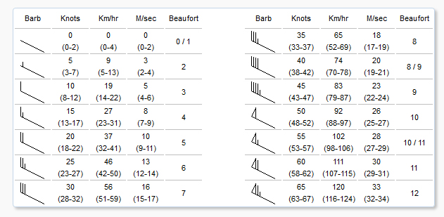
Drotik deine Beschreibung ist besser als meine :) Hab dazu noch was ganz eindeutiges gefunden: https://de.m.wikipedia.org/wiki/Windrichtung#/media/Datei%3ASymbol_wind_speed_13.svg
-
Moin, die Fähnchen liegen quasi im Wind. Das heißt die Windrichtung weht von dem Drehpunkt zur Spitze.