MikeMikeJuliet
-
Posts
1212 -
Joined
-
Last visited
-
Days Won
1
-

Exemption of AMPCD maps from Integrity Check
MikeMikeJuliet replied to MikeMikeJuliet's topic in Wish List
Well, that would effectively do the same thing. I don't mind which way it is done, as long as it would be possible to customize the maps. Install-folder or savedgames, all the same for me as long as the functionality is there. -
Hello! I have a request considering the maps in the module's installation folder that are used on the HSI-page in the AMPCD that these could be exempted from IC. The reasoning is twofold: first off, all the maps can be customized in the actual aircraft by Mission Support, and so we should be able to do that too. I am not arguing for a tool to make the maps, just that we would be able to alter the files as we need to. Secondly: the current map with the current gain and the green symbology is really difficult to read at a glance. Even at lowest gain the symbols tend to not be bright enough and the map dark enough to read the display as easily as we should be able to. The benefit for adding an exception in the IC is that we could simply go throught the maps and adjust their brightness to a darker tone (I've tried this and it works really well), or the players could even modify the maps to the specific needs of a specific mission, drawing custom areas and borders etc in the maps, instead having to rely on a specific map that in many cases doesn't suit your needs. I do not see how having the maps under IC provides any protection against malicious player behaviour. IRL you can have what ever kind of map under your HSI that you need. This would greatly enhance the usability of the moving map in the F/A-18 Thank you for considering! Regards, MikeMikeJuliet
- 2 replies
-
- 9
-

-

-
- map
- integrity check
- (and 3 more)
-
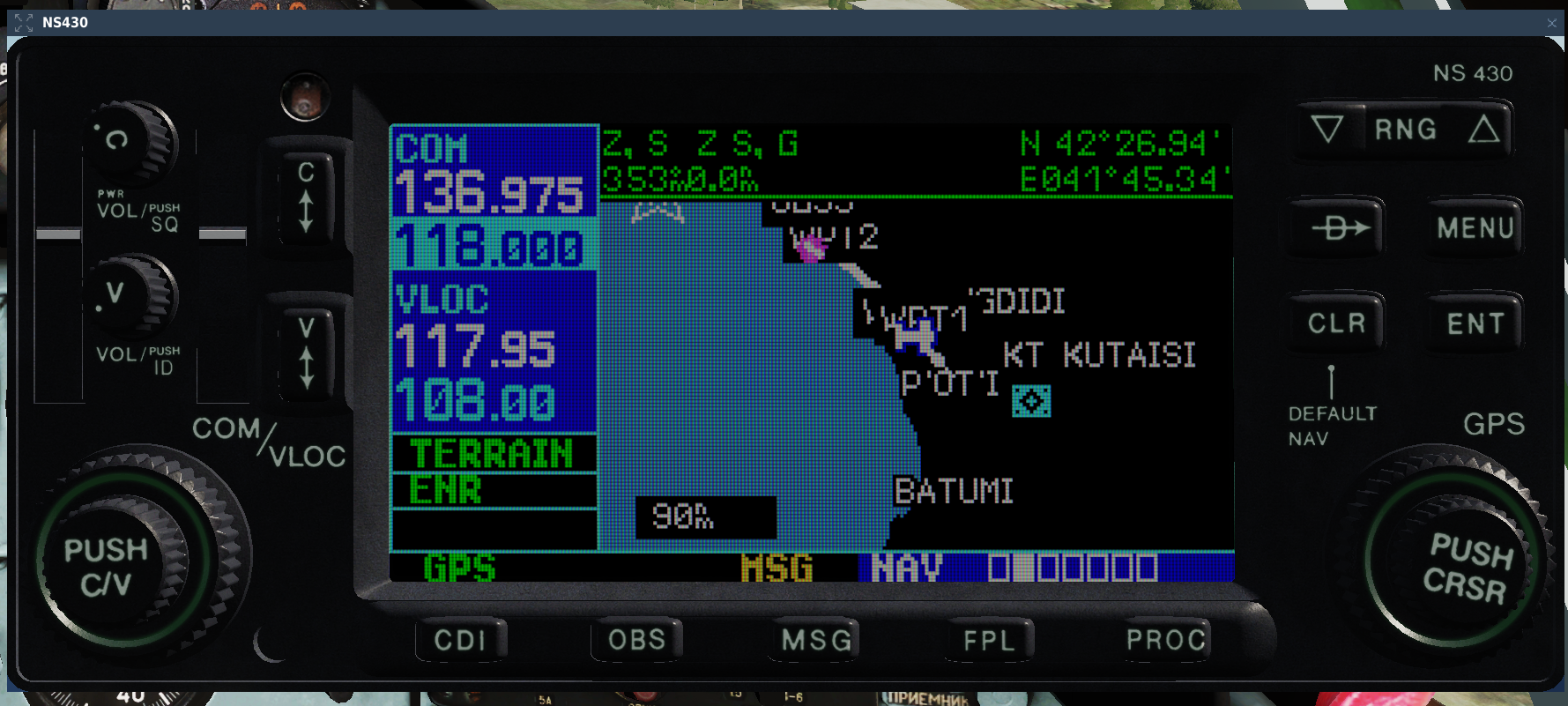
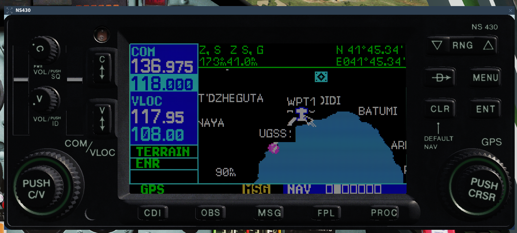
Here's another set, this time active pause is used. Caucasus, Su-25 instant action. Cursor is pressed, leaving it on the aircraft position. First one is again north up: And second is track-up: As you can see here, both coordinates show the same point in track-up. The difference is also not as noticeable because both coordinates are pretty close to each other. The position of the cursor has not changed and neither has the aircraft's pos, so it's not that. Regards, MikeMikeJuliet To the last post, here's another thing: Exactly same position, but I move my coursor to the left in Track-up (to the north) which makes the latitude decrease in stead of increase. Longitude has changed logicalle (the heading of the aircraft is about 098, so moving the cursor directly left does not equal exactly north which would keep the latitude unchanged) I hope these help to get to the bottom of this Regards, MikeMikeJuliet

-
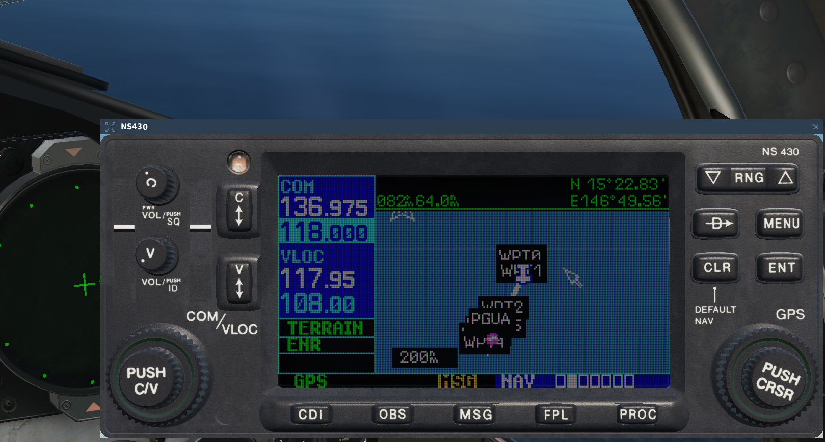
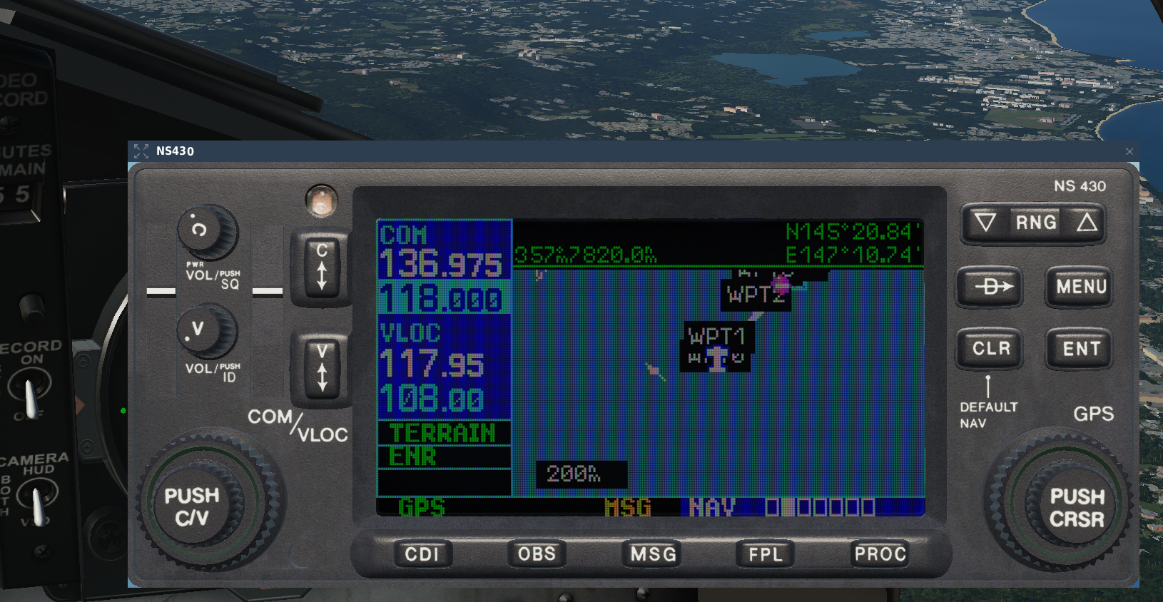
And I forgot... Alright, here's a screenshot form the Marianas F-15C freeflight instant action, note the coordinates (cursor east of aircraft postition, North-up mode) And here's the same situation, but in Track-up mode, cursor again on the east side of the aircraft (left side): I wasn't on active pause so the aircraft moved a bit (as you can see from the background) but that is besides the point. As you can see, in the track-up mode the latitudes are completely bonkers and exceed the limits for 90 degrees N/S by some 55 degrees Regards, MikeMikeJuliet
-
I would imagine that if we get a tutorial considering the radar, then we can surmise that the module release is imminent. As long as no video covers that we can safely assume that the radar is not functioning properly yet and will thus hold the release. This is my guesstimate anyways Regards, MikeMikeJuliet
-
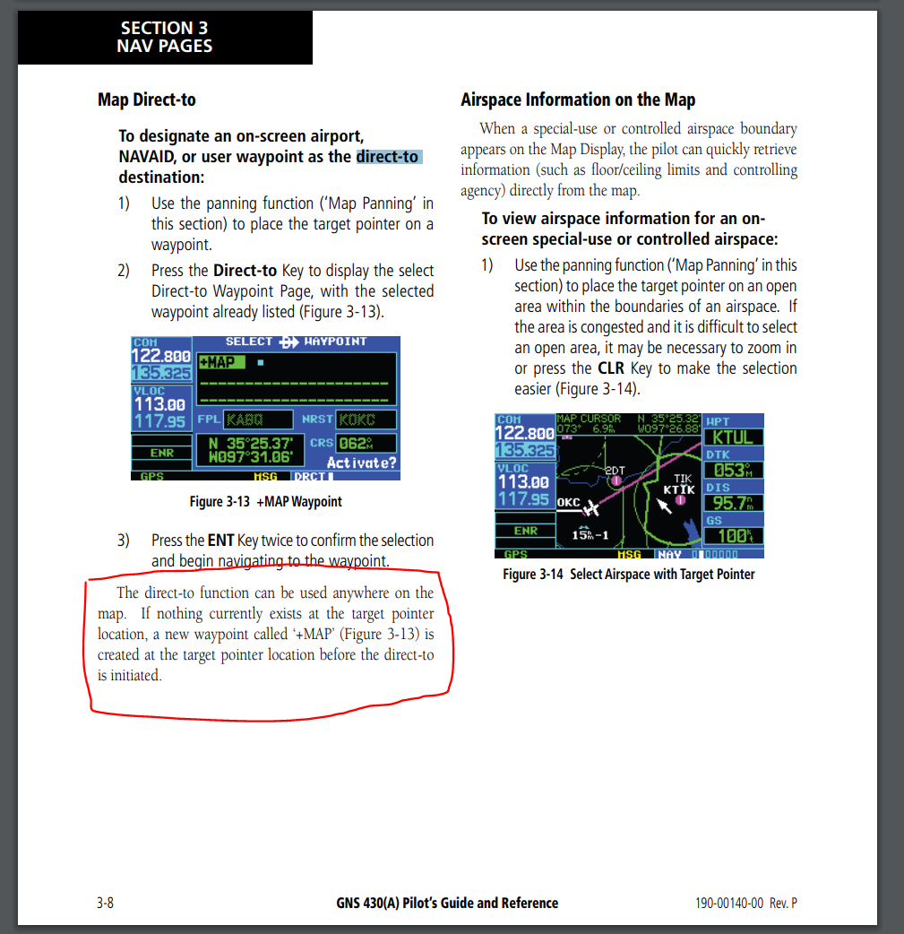
Hello! Having used the real counterpart to the NS430 quite a lot, I am requesting a feature to be added to the cursor when in map mode. Currently: When you activate the cursor when in the map screen and move the cursor to any arbitrary location and press the Direct-to -button, the NS430 presents you with either your current location (the airfield you are at if you are on the ground) or alternatively the point that the cursor is over (though this bugs out at times). Request: As per the real device, if you set the cursor at a point on the map where there are no waypoints (user generated or otherwise) the device should present you with a new user waypoint marked "+MAP" with the current cursor coordinates. This allows the user to set their destination quickly to any point on the map without needing to first navigate to the user waypoint menu and then build a new waypoint by setting coordinates. The following picture is taken from the official GNS430 manual (https://static.garmin.com/pumac/GNS430_PilotsGuide.pdf) Regards, MikeMikeJuliet
-
A little update on this topic. I just tried to replicate the bug on the Mariana islands, and you can see the bug there in action very well. In essence if you set the Track-Up mode and activate the cursor in the map screen, you will see your latitude at around the same ballpark as your longitude (which should be impossible, given that the longitude is around 140-150 degrees, and latitude naturally goes up to max +/-90 degrees). I will try to post a screenshot later today.
-
Yeah! I really like these "a bit of modern things, but still very much analogue" -types of aircraft. Really waiting eagerly for the F1
-
I do really think the only reason is that back in the day when DCS was built (or rather the core which is way older) one system was chosen instead of implementing multiple, because there is no reason you couldn't play just fine with what we have now. As a counter point to this being a tecnical limitation, consider the following: in VR this already works when using in-game menus (the esc-menu for example). While the menus are active the mouse is locked to the scene and you can look around just fine. No warping or twitching of the cursor (as if this was done by somehow compensating the motion due to head movement after it has moved). It's solid. It works and it is wonderful! Problem is it does not work in any other instance. And I believe the reason is just simply that no-one ever found it that necessary to implement before. I would argue that this would definitely be an option to be implemented. I know I and many of my friends would switch instantly. At the same time I know a lot who prefer the current system. Hence options. Regards, MikeMikeJuliet
-
Hello, it seems that there is a bug when setting up user waypoints via the map cursor while the map is in track-up -mode. In said mode the waypoint seems to get the correct coordinates as was shown in the cursor info-box, but then when I set the navigation to said point, the waypoint is far away from where I originally put it, even though when I check the coordinates from the user waypoint list all seems to be correct there. If you use the north-up -mode everything works just as intended. So it seems, that even though the NS itself show the proper coordinates, the actual position is copied from the screen as if it was north-up. Very confusing indeed! I found this flying in Caucasus. Haven't tested on other maps. Testing is simple: set the map to track-up, fly somewhere other than north and try to set up a user waypoint via the map (notice the coordinates!), set the direct-to function to the waypoint you just created and observe the result. Regards, MikeMikeJuliet
-
What has been the closest that two modules have been released from eachother, not counting campaigns? Because I don't think ED wants to push modules out too close together even if they do not directly affect eachothers sales. Q1 does not necessarily have a january patch since ED usuaöly have their holidays through much of january... and give that major patches come out once a month now *and* the Apache is most likely coming out first, it could be that March is too early for the F1. Hopefully I'm wrong and we do indeed see the Mirage out sooner rather than later, but I have my reservations at this point. Then again if ED get's to squeeze the Apache out end of January it could be that we might see the F1 com out in Q1... "Soon" in DCS-terms is, typically, actually something between "not quite so soon" and "around a year from now" Regards, MikeMikeJuliet
-
Yes please!
-
I understand your frustration, but at the same time I ask you, where did I say that this ought to take priority as no.1 fix for the F-15? The way you have formed your answer gives out the impression that no bugs/oversights are allowed to be reported before every bug/oversight more important than the one being reported are addressed. And by making that priorisation you also imply that you know the absolute order of issues to be fixed/improved on the module. Regards, MikeMikeJuliet Thank you!
- 11 replies
-
- 3
-
-
- altimeter setting
- keybinds
- (and 2 more)
-
Hello, most of you probably know this already, but I'm bringing this up again. The F-15C (and the A-10A) does not have any altimeter setting keybinds. This effectively means that the barometric altimeter cannot be adjusted, which is a critical oversight especially considering the probable rise of instrument flying due to the new (amazing) clouds and the upcoming weathersystem overhaul. This has been an issue for years. I believe I last posted about this like 4 years ago. The other FC3 aircraft apart from the A-10A have the binds (so the A-10 should get these too, along with the F-15) and the do work, for reference. The name for the keybinds are: "Altimeter Pressure Decrease" and "... Increase". I hope this is finally resolved to bring all the modules to the same state systems-wise within the FC3. Regards, MikeMikeJuliet
- 11 replies
-
- 2
-
-
-
- altimeter setting
- keybinds
- (and 2 more)
-
MikeMikeJuliet changed their profile photo
-
Yeah, I'm aware. Must be an oversight by ED because the keybinds are there but they do nothing... I think a reminder might be in order