

bephanten
-
Posts
101 -
Joined
-
Last visited
Content Type
Profiles
Forums
Events
Posts posted by bephanten
-
-
ai will abandon the plane with empty fuel, even on final approach or on the flare over the runway.
-
once, nick the gray told a story that a new gunsight was being forged deep within mount doom.
-
same problem here. works ok for first time. then it does not work. i also have a keyboard modifier bound to the pov button for the command.
-
does this thing have aesa radar simulated?
-
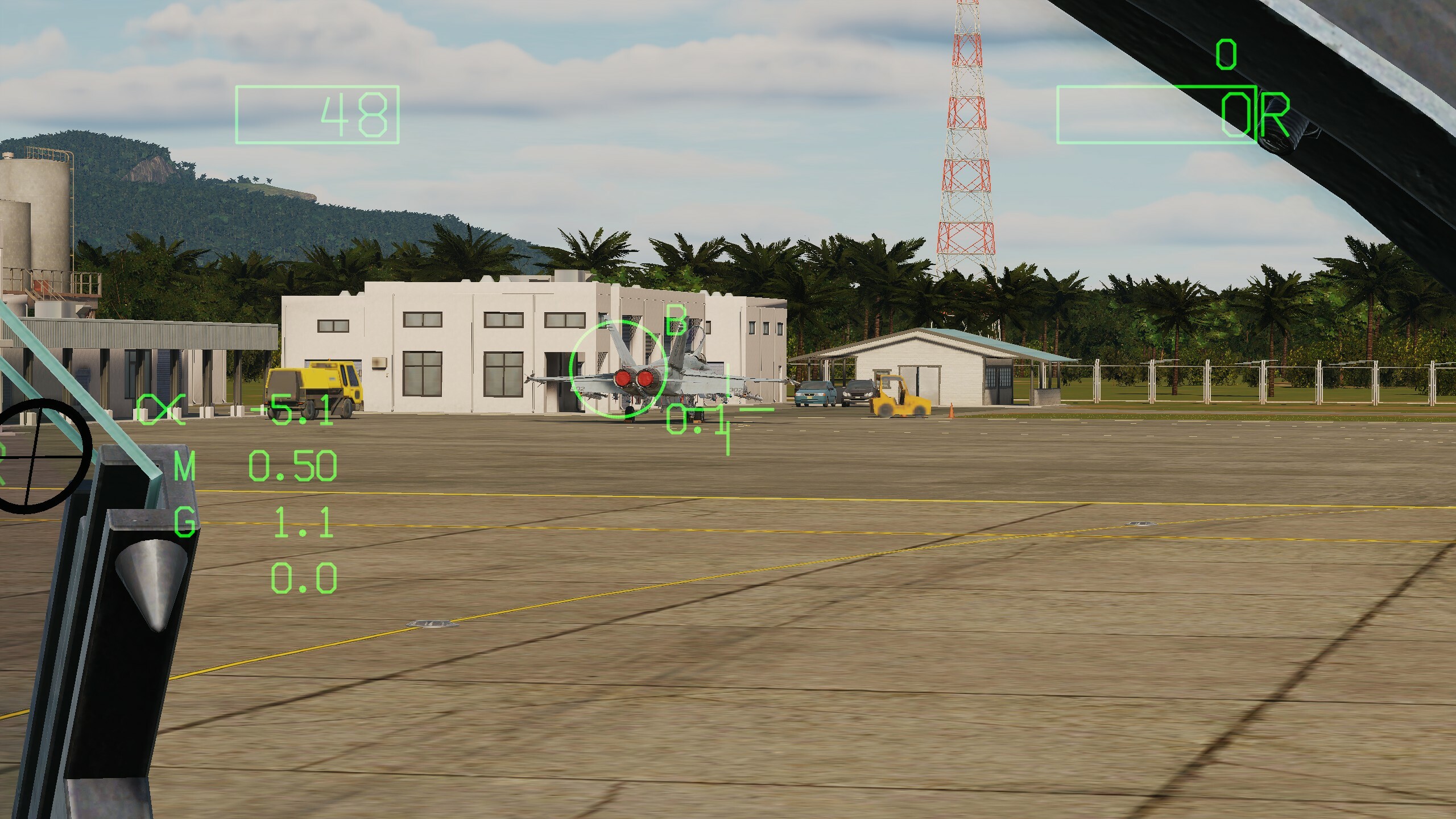
as title says, i see a weight difference about 300lb between civil plane checked/unchecked. it has no effect on 3d model. i deselect external hardpoints.
maybe dcs is simulating the burden of ptsd?
-
17 minutes ago, Gunfreak said:
No problemchasing either of them in my P47. Dive after them then hall them in as they do lazy turns and shoot until they burn.
The P47 AI does it too. Just dive for the deck.
Exactly. Jug is a good diver too. But ai and its flight model is joke. There is no energy fighting routines for ai.
-
The devs may have decided this exclusively for fucke Wolfe's. They can recover from high speed dives relatively easily. Try chasing a diving Dora to the deck. You may likely lose control and crash.
-
an ai spitfire with attached bombs in belly and wing hardpoints also fly and dogfight like the sleek one. it can climb and turn with the german birds.
i set up a mission where i have a clear altitude and weight advantage against a jettison restricted bomb loaded spitfire. it can defend my bnz with pulling endless verticals. in same scenario, a p47 cannot pull same verticals.
-
new sounds are waay better. it feels like a proper engine now. but the rpm surge of mw-50 still feels odd.
-
ed should have a guideline for canopy glass graphics.
starting with, no effect should hinder total visibility under any condition. i've waited so long for new spitfire cockpit, and the old blinding sunlight reflection has carried over to new cockpit. i don't know, if you're planning to solve these problems with vulkan raytracing. but there is definitly a problem with testing. i would have rejected the new canopy. the effects should be subtle, not in your face.
-
 3
3
-
-
Impressive. I hope your framework becomes a standard for DCS modules and other 3rd party developers
-
1
-
-
Does virtual component system allow failures in individual warning panel lights. Like there is a fuel system problem, but it's warning light is faulty.
-
How would a 3d model update by developer would affect this project?
-
I was kind of wondering about use of raytraced audio and procedural audio. There are limitations to the current engine. For example engine sound does not behave similar to gun sound, where you can hear delay with gun sound based on distance but any change in motor rpm will be heard instantly in external camera.
-
the newsletter about core development does not include anything about audio effects and sound in general, besides atc and voice chat. is there any development in audio department?
-
1
-
-
about serenity's bug list, no 2 wing disappearing bug. attached a track file of an example.
-
the link still works after my ai wingman shuts down his engine. my engine and systems are running though. is this expected?

-
4 hours ago, Abburo said:
Are you going to be Grinch today? :)))... These are guided projectiles, not missiles .... so they are quite limited on their correction capabilities. There is also a reason setting up different skill levels for the units... right?

of course, the skill levels are there for a reason. but average skill does not react to a flying over ai plane in my mission. the same unit with a higher skill level reacts to the same scenario. and the ai planes are ww2 birds. not f22s
-
russian 2s38 spaag(lg-he) unit has a peculiar weapon. its aa projectiles behaves like homing missiles. they seem to track the target. is it a bug?(just watched the projectile in f6 screen, it has fins.)but the unit does not track target when its skill level is set to average.
-
53 minutes ago, razo+r said:
One option could be to place the waypoint some distance down a valley, preferably a straight segment. Then, after looking up the valley on a chart, measure the heading of the valley. After that, make sure your ingress heading towards that waypoint matches the heading you measured, and then descent on that heading towards, or away from that waypoint.
As an alternative, you may aswell use a chart to navigate to a flat place of land where the MSA is below the cloud layer, so you can descent without much thinking.
this is good but requires preplanning. the video looks like what i was looking for. thank you
-
i set up a mission where i follow waypoints through a canyon in caucaus. weather is overcast. there is a mountain at the end of canyon. i climb over the mountain through cloud cover. now i have to dive through clouds. but cant see terrain. how should i use the radar or other sensors to dive and not die?
-
does this mode support force feedback joystick?
-
a blinding flash happens from time to time when flying the apache. it happens although all external light of vehicle is off. it behaves like a strobe light. very disturbing. it is more prevalent in night missions.
-
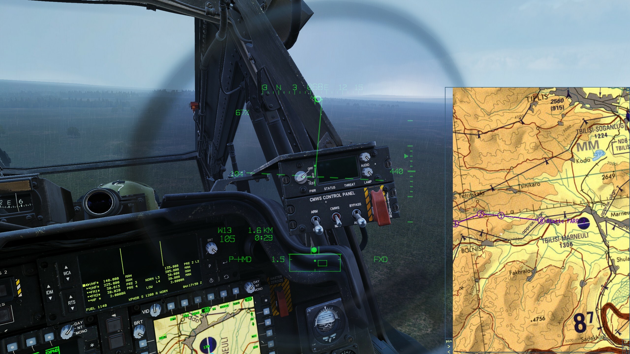
tblisi-marneuli airfield is visible in tsd map. it does not exist in actual map.
Ground electric and air power start
in DCS: F/A-18C
Posted
if your second engine is not starting, tell crew to apply air for a second time. odd it is.