
Recoil16
-
Posts
797 -
Joined
-
Last visited
-
Days Won
1
Content Type
Profiles
Forums
Events
Everything posted by Recoil16
-
Already reported, thank you
-

Approach and Departure charts, AIP and Enroute Charts
Recoil16 replied to ViFF's topic in DCS: Sinai Map
The latest domestic AIP can always be found here: https://www.gov.il/he/Departments/Guides/aip?chapterIndex=1 The link in question says "פמ"ת בקובץ יחיד - הורדה" ("PMT in a single file - download", according to Google Translate). That being said, the current direct link to the PDF is here: https://www.gov.il/BlobFolder/guide/aip/he/aip_Full PAMAT 3-23.pdf -
Just to be clear, while this will "fix" it in the sense that you can then use the TACAN, the problem is not actually with the Hatzerim TACAN. It is confirmed to be on 96X by Israeli Air Force documentation. It's rather the Wadi Al Jandali TACAN that is either on the incorrect channel, or (in my opinion more likely) it should not exist at all, as there is no antenna visible on real world satellite images where the Wadi TACAN is placed in game. So yes, while this is an interim "fix" you can do for yourself in the moment, this should not be the long term solution to be implemented for the map as a whole.
-
Yeah, as pointed out by Ahmed, this is not a bug, rather it is expected behavior that has (finally) been implemented after it was missing for so long. The DME component of a TACAN beacon is functionally the same as the DME component of a VOR/DME. @BIGNEWY I think we can close this as "correct as is".
-
reported A bug in the taxiway damaged A-10 landing gear.
Recoil16 replied to Heliflyr's topic in Bugs and Problems
An excellent point actually. DMS coordinates without decimal seconds as given here are only accurate to about 30 meters (in latitude, with longitude precision differing depending on the latitude but let's not get into that right now), which is 100ft as you say. -
reported A bug in the taxiway damaged A-10 landing gear.
Recoil16 replied to Heliflyr's topic in Bugs and Problems
It's an easy way to show to the devs exactly how, where, and under what circumstances damage is occurring, which is presumably why Flappie is asking for it. A coordinate - while it points out the bump - doesn't do that. -
Runway lights not visible at distance; overall too dim
Recoil16 replied to Nealius's topic in Bugs and Problems
Previously reported internally- 1 reply
-
- 1
-

-
Correct, and it has been reported. I'll see if it can be bumped again.
-
I agree with Minsky that you should supply a track, or at the very least tell us which specific TACAN channels you're seeing this on. Sinai currently has multiple duplicate TACAN channels (all reported I believe), so if you're on one of them you may be seeing different TACAN stations "fighting" with each other.
-
I agree with ASAP, you should probably try something lower. 15k/215 KIAS (+/-) is a quite comfortable place, which is in line with the NATO AAR planning docs.
-
@tripod3 Line 60 of sensors.lua should read declare_sensor(TALL_KING) it currently reads declare_sensor(BAR_LOCK) Due to this small error, the radar does not actually properly detect targets, as it has no valid sensor.
-
This is previously reported internally.
-
Nellis Charts for year 2011
Recoil16 replied to dcs76's topic in DCS: Nevada Test and Training Range
You can find the 476th Nevada FLIP in their shared publications: https://www.476vfightergroup.com/content.php?381-shared-publications -
Hey, in principle, yes, I just haven't gotten around to it in a while. I'll probably try to tackle it when I find some spare time next to other projects.
-
Approach and Departure charts, AIP and Enroute Charts
Recoil16 replied to ViFF's topic in DCS: Sinai Map
I wouldn't really be concerned with sim organizations (like virtual squadrons) using them without proper licensing, likely nobody is gonna care. But shipping them as part of a commercial product would be another thing. -
Sorry, should have been clearer. It was previously reported internally.
-
Joint-use (Civil-Military) airfields need fixes ...
Recoil16 replied to Backy 51's topic in Bugs and Problems
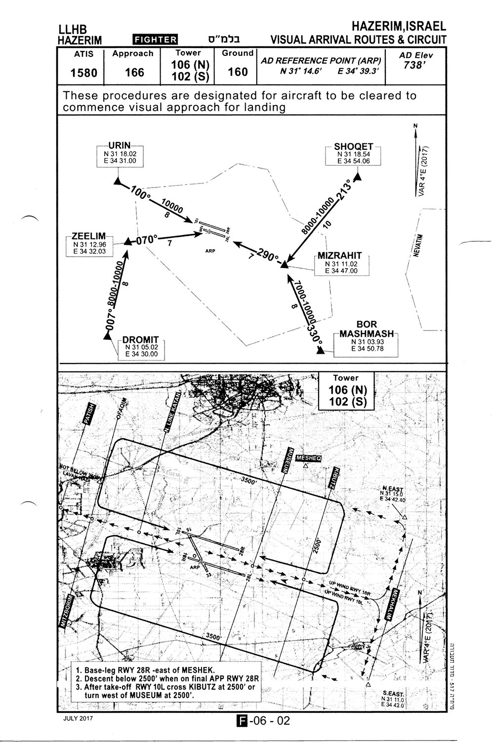
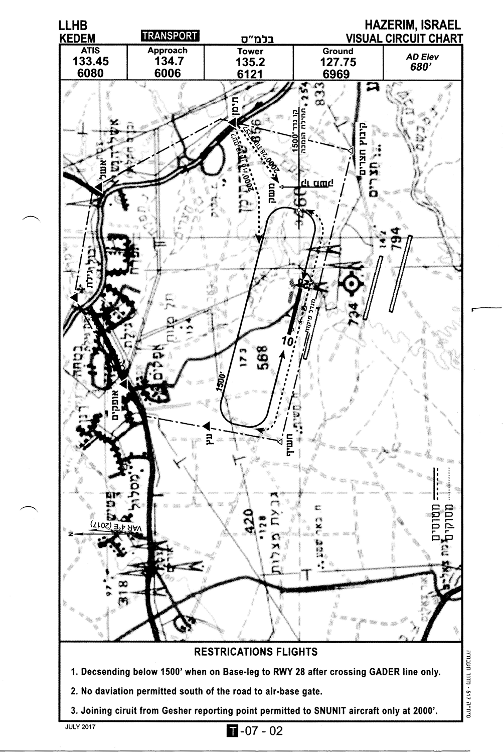
I have some approach charts, including the visual circuit chart for Hatzerim "proper", yeah, see below. Hatzerim is not a joint-use complex (if you mean mil/civ by that). Hatzerim and Kedem are both military, as I understand it's one installation with two airfields. Kedem in the north being used for the IAF flight training, Hatzerim main field being a "proper" military airfield. There is no taxiways between the two, aeronautically they are two distinct airfields (albeit apparently share the same ICAO according to the data I have), they even have separate towers.
-
Joint-use (Civil-Military) airfields need fixes ...
Recoil16 replied to Backy 51's topic in Bugs and Problems
I think you may have accidentally re-sent a previous message? -
Joint-use (Civil-Military) airfields need fixes ...
Recoil16 replied to Backy 51's topic in Bugs and Problems
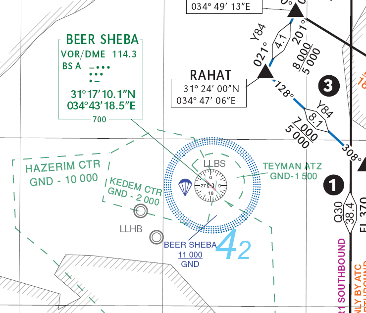
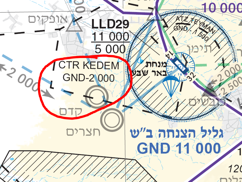
See this Israeli Air Force visual circuit chart for Kedem, dated 2017: Note it is clearly designated "Kedem", with ICAO LLHB. See also the "CTR Kedem" on these enroute charts from the Israeli AIP:
-
Joint-use (Civil-Military) airfields need fixes ...
Recoil16 replied to Backy 51's topic in Bugs and Problems
Israeli Air Force charts indicate it shares LLHB with Hatzerim, being technically part of Hatzerim Airbase. -
Approach and Departure charts, AIP and Enroute Charts
Recoil16 replied to ViFF's topic in DCS: Sinai Map
I wouldn't be so sure. SkyVector, and likely some of the other maps and charts there are copyrighted and not freely licensed or in the public domain. -
This was already reported previously.
-
Joint-use (Civil-Military) airfields need fixes ...
Recoil16 replied to Backy 51's topic in Bugs and Problems
Disagree. Israeli Air Force airfield charts as well as the Aeronautical Information Publication (AIP) Israel have this airfield as "Kedem". -
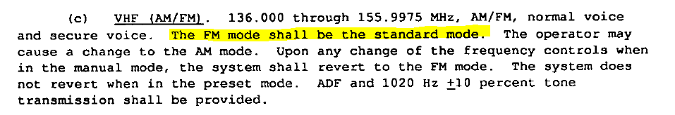
Can not set the Vaziani VHF AM frequency.
Recoil16 replied to JetJake76's topic in Bugs and Problems
This is not a bug. FM should be the default state between 136.0 and 155.975, see page 34 of MIL-R-29583 (of 1 July 1992, Approved for public release; distribution unlimited, LINK), the specification for the ARC-210 (relevant excerpt below). You can just use the AM/FM button on the radio control head to switch to AM.
-
They weren't done by ED, but by @static_actual as part of the AH-64D livery competition if I recall correctly.