pet333r
-
Posts
325 -
Joined
-
Last visited
Content Type
Profiles
Forums
Events
Everything posted by pet333r
-
Try manually removing the script and reinstalling it
-
New version 1.0.2024.0106 avaible - changed graphics for most panels - added 'F' communication buttons on the MFD panel - M-2000C PCN: fixed data display on LCD - A-10C added illumination of engine/APU fire "switches" - F/A-18C IFEI: data display improved - F-16C added the ability to save the color of the DED display - added checking the installed script version - added information about 'high contrast' mode enabled - optimized the size of some switches - changed icons in settings - app code has been optimized
-
New version 1.0.2023.1230 avaible - added Android 14 support - added data display in MGRS format - NS430 support - module data corrected - changed icons in Settings - little fixes
-
New version 1.2.2023.1220 avaible - added AoA for Mirage 2000C - added Android 14 support - changed icons in settings - minor fixes
-
The application is used to operate the F1-F12 buttons (communication menu in DCS) in the DCS Nav application. For normal panel operation in DCS UFC, it is not required
-
New version 1.0.2023.1014 avaible - added user machine icon change (plane/helicopter) - added ability to change the type of data display (metric / imperial) - added version checking of the script installed on the PC - added information about not displaying some data depending on server settings - added saving of map zoom settings and GPS data type - added player callsign - changed position of mission time display - fixed the display of the frequency of objects on the map - fixed the saving settings on the device - fixed line removal between user and object during map change - fixed display mission time - fixed display on devices supporting "Right-to left" mode - clearing the window the data of the last selected object - changed information on setting the IP address - added link to privacy policy
-
New version 1.2.2023.0520 avaible - added AoA for Mirage F-1 - added Android 13 support - changed the minimum version of Android 4.1 > 4.4 - some indicator colors have been changed - fixed display on devices supporting "Right-to left" mode - code optimized
-
Finally a new update is available, inside a lot of new panels for several machines. It took me a while, but there were a lot of changes, especially in the application code, because what "you can see" is maybe 20% of the changes. I fixed a lot of things, including some of the ones described here in the forum posts. But for sure there is still something to improve so now I'm going back to work... changelog for 2023.0430 - A-10C: added V/UHF radio panel ARC-210 / autopilot - FA-18C: added IFF/ILS/VOL panels - AV8: added SAAHS / Fuel panels - AV8: added ELEC / VUHF / ACNIP panels - AV8: added Lighting panels (internal/external) - JF-17: added ELEC / ACP - JF-17 changed font on UFCP - JF-17 MFCD added support for switches - F-5E: added Lighting / Weapon panels - F-14 the entire engine panel has been changed - F-14 ACMP fixed Master Caution button - F-14 Lights changed the font size on the knobs - F-16C UHF: fixed radio frequency knobs - A-10C AAP: changed handling of switches - F-16C ICP: fixed display of DED in portrait mode - FA-18C UFC: LCD display improved - A-10C CMSC improved data display - Ka-50 fixed Datalink panel - Ka-50 PVI fixed swipe panels - M2000 PPA fixed AUTO switch - changed a large part of the graphics for: A-10C / AV8 / F-16C / F-14 / FA-18C - resized buttons of some configurations for better handling - removed graphics on some panels - fixed context menu on MFD and JF-17 panels - information on setting the IP address has been changed - some switches changed - application code optimization

-
New version 1.0.2022.1126 avaible - F-16C: added Lighting panel (External/internal lighting) - F-16C: changed right console panel (SNSR, HUD, Avionics) - F-14: added RIO warnings panel - Ka-50: added Datalink panel - AV8 UFC: added "clicking" COMM's knobs (by clicking on COMM LCD) - A-10C CDU: STEER switch fixed - added information during the first run about the need to install the script on the PC - fixed display on devices supporting "Right-to left" mode
-
New version 1.0.2022.11.11 avaible - changed default receive port - added the ability to disable the display of enemy units - added the ability to change the display type of GPS data (to change click on the displayed data) - added the ability to add your own markers / waypoints on the map (up to 5) - added line between the user's machine and the marked object on the map with displaying the current distance to that object - added display of additional information (A/A, A/G, Arm, landing gear, distance to selected object) - added speed brake open indicator (for some modules) - fixed displaying of user direction on map - fixed display of some data on different types of devices
-
New version 1.0.2022.0819 avaible - A-10C: added COMM 1&2 on radio panel in portrait mode - F-14: added AFCS panel - F-16C CMDS: FL switch fixed - Ka-50: added cautions panel - Ka-50: improved display data and the display of the ABRIS button options has been added - FC3: added ability to switch between panels - added protection against application crash in case data from DCS are already being sent to another application on this device - changed some graphics - added Android 13 support
-
It is possible that I will also add the option of displaying ground units, but more as an "experimental" option because these objects are often hundreds or even more during various missions, and for some devices (usually older and slower), such a number of objects on the map may be difficult to handle.
-
1. This is something I would also like to add, a question of finding some good solution not to change half of the application code 2. I even worked on it, the problem is that each panel and even each OSB button uses a lot of different data (it is not standardized in any way), it would require a huge amount of data checking 3. Pretty good idea, I need to check 4. It is also an idea that I would like to implement if it is possible 5 & 6. It won't be too complicated Thanks also for the criticism, it is also important to me At the very beginning, update the entire script, it is possible that you have an older version and not everything works as it should (e.g. displaying the position on the map). And the application at that time has been significantly changed to make the best use of the possibilities. As for the minimization of DCS after starting DCSUtil, I have not encountered such behavior yet, nor has anyone written about it before, I will check what may caused that because it's a bit strange As for the application that installs the script, I wrote it to make script installation as easy as possible for users. Because some people encounter scripts in DCS for the first time or are just not sure where to copy it. As for the uninstall option, this is of course something that can also be added
-
I am working on making both applications run on the same device at the same time and am well on my way to fixing this issue
-
Send me the entire "Scripts" folder (along with all other files, not just my script) via e-mail: piotr.wos.developer@gmail.com
-
You also have an updated Config.lua file? If you have the option to report a bug when it occurs, please do so, I will have more information on where to look for the cause of the behavior
-
Click on the link to the application, you will see the amount in the currency of your country
-
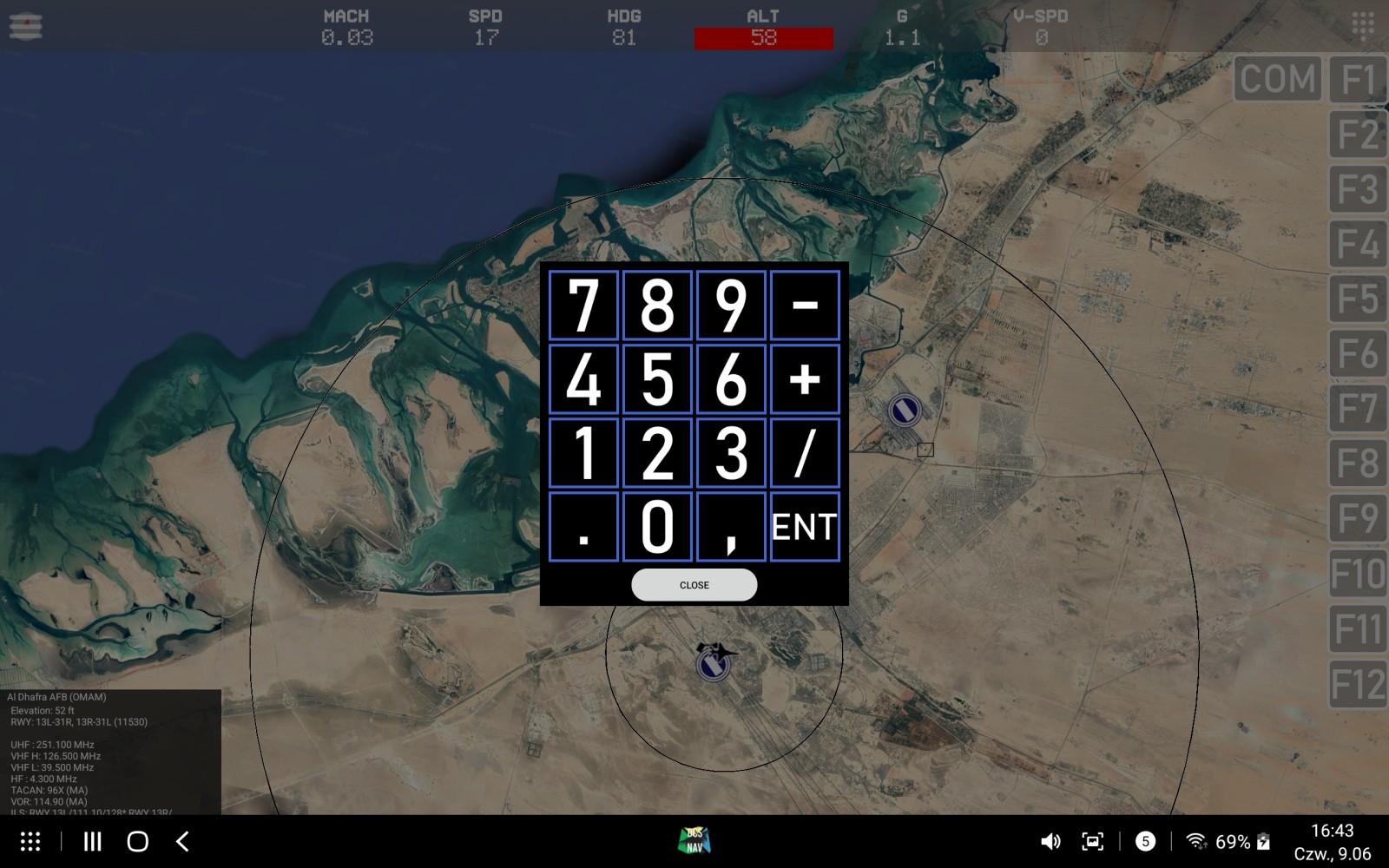
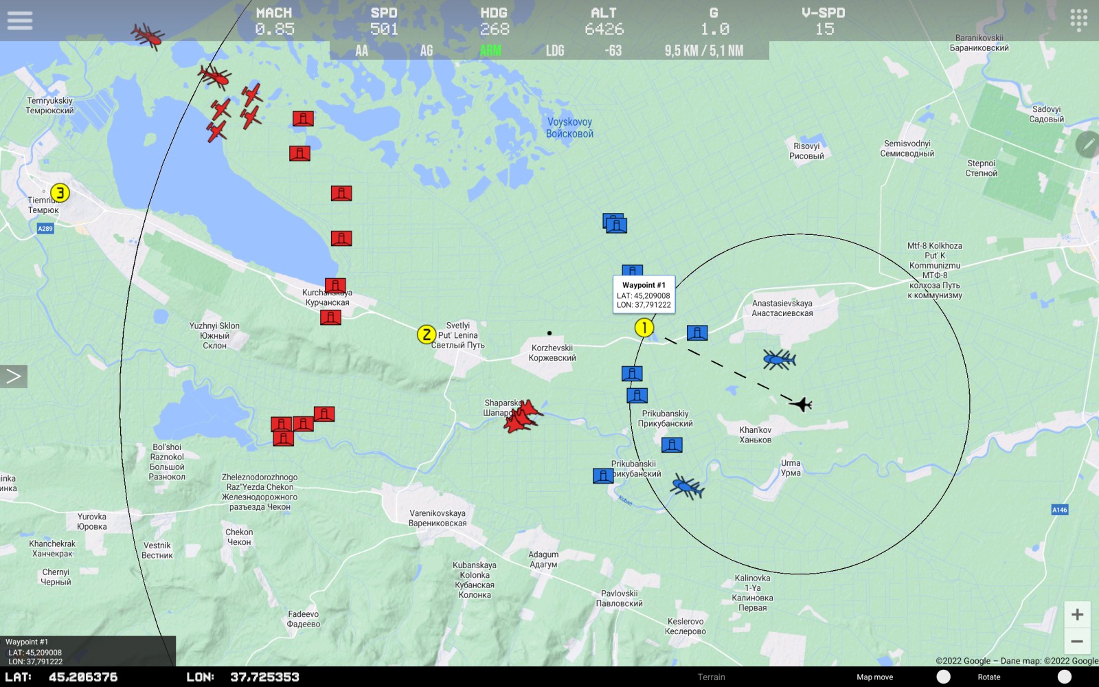
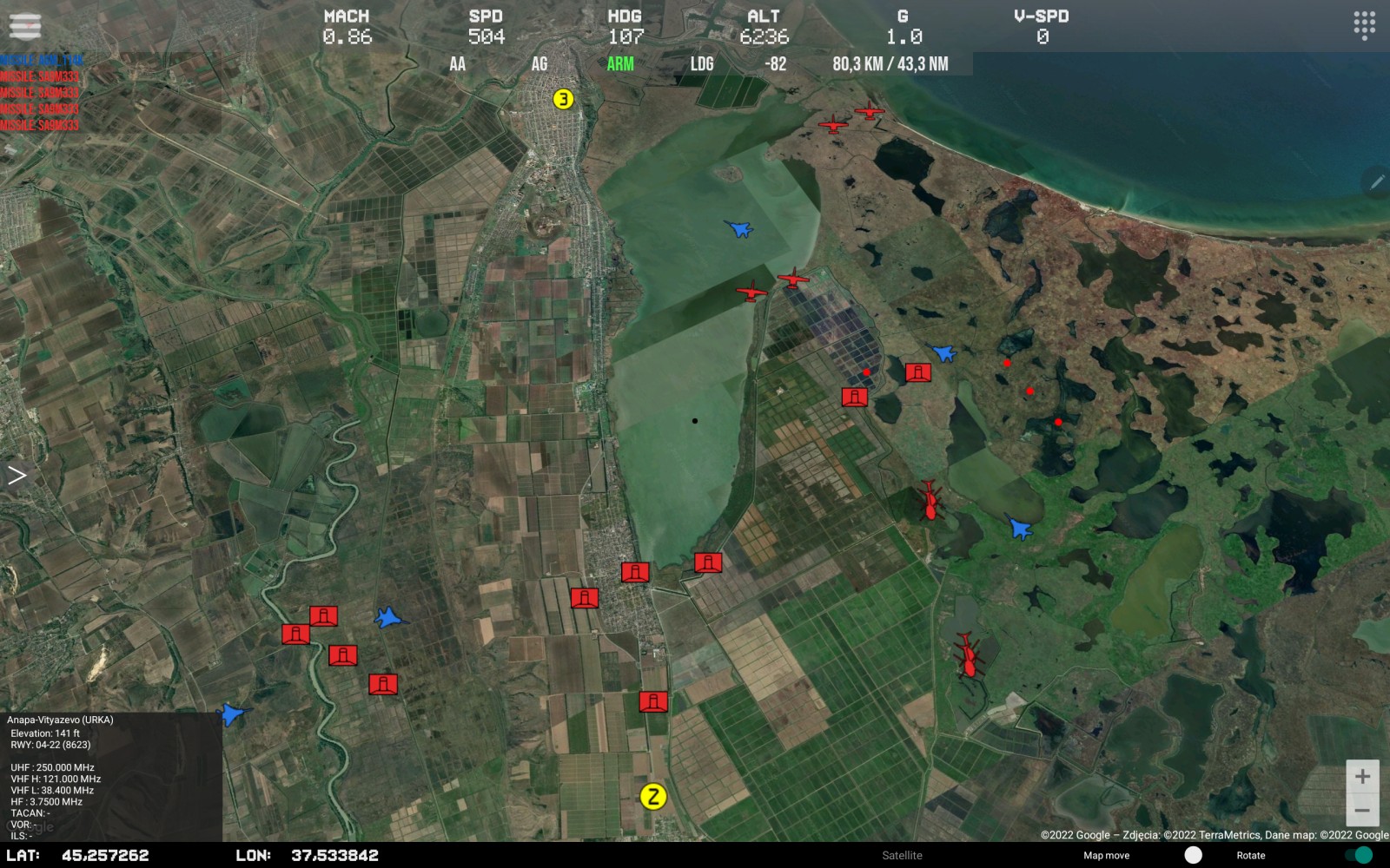
Want to be up to date, look here: https://www.facebook.com/pw.developer Description Navigation system and radar map for DCS World For working You need to download and install Lua export script for DCS World from here (detailed information on how to add a script to DCS World can be found on the same page) https://github.com/pet333r/pw-dev_script main functions: - displaying your own position and data (metric / imperial) - NS430 support - displaying the radius of a circle around the user module - displaying the position of other objects: airplanes, helicopters, ships - SAM launcher position display - displaying information about current missiles in the air - displaying airports on the map with information - display of available ILS tracks with navigation information - display beacons (TACAN, NDB, VOR etc) - displaying different icons depending on the type of object - displaying map boundaries - displaying NTTR boundaries - displaying the line between the user and the selected object along with the current distance - display of additional information (A/A, A/G, Arm, landing gear, distance to selected object) - radio altitude limit warning - change of frequency of data reception from DCS World for individual objects - ability to enable/disable displaying individual objects on the map - option to add waypoints on the map (up to 5) - change of map type - display of GPS data in the following standards: DD / DMS / MGRS - side menu with the ability to quickly change the display of objects on the map - support for DCS Util app - works with any module DOWNLOAD: https://play.google.com/store/apps/details?id=com.pwdev.dcsnav Video: Pictures: Versions: 2023.12.30 - added Android 14 support - added data display in MGRS format - NS430 support - module data corrected - changed icons in Settings - little fixes 2023.10.14 - added user machine icon change (plane/helicopter) - added ability to change the type of data display (metric / imperial) - added version checking of the script installed on the PC - added information about not displaying some data depending on server settings - added saving of map zoom settings and GPS data type - added player callsign - changed position of mission time display - fixed the display of the frequency of objects on the map - fixed the saving settings on the device - fixed line removal between user and object during map change - fixed display mission time - fixed display on devices supporting "Right-to left" mode - clearing the window the data of the last selected object - changed information on setting the IP address - added link to privacy policy 1.0.2022.1111 - changed default receive port - added option to disable the display of enemy units - added option to change the display type of GPS data (to change click on the displayed data) - added option to add your own markers / waypoints on the map (up to 5) - added line between the user's machine and the marked object on the map with displaying the current distance to that object - added display of additional information (A/A, A/G, Arm, landing gear, distance to selected object) - added speed brake open indicator (for some modules) - fixed displaying of user direction on map - fixed display of some data on different types of devices
-
Add this folder to some cloud service (Google Drive, Dropbox etc) and send me a link to the shared folder. Google often doesn't allow add lua files as an email attachment because it considers them "suspicious".
-
Send me the entire Scripts folder and screenshots with IP addresses of your devices. I will check where the cause of this may be
-
Check if the IP addresses of the devices are correct, it is possible that the router assigned them new ones Info for DCS UFC app users who have the new South Atlantic map. Please update the script to the latest version so that everything works properly when flying on this map. To do this, just run the "update_pw-dev_script" file in the script folder. https://github.com/pet333r/pw-dev_script
-
replace the files responsible for the update in the script (update.ps1 - download from github), it is possible that you have an older version of this file that previously had to be updated manually this is how it works at the moment a few people have already written to me about this, I'll try to come up with something The A-10 will definitely get it --------------------------------------------------------------------------------------------- New version 1.0.2022.0520 avaible - F-16C: added ECM panel - JF-17 changed panels graphics: COMM, external / internal lights - AJS37: updated warning colors on the right panel - FA-18C: added "clicking" COMM's knobs (by clicking on COMM LCD) - added window with information about the configuration of MFD / JF-17 MFCD panels - removed unnecessary files - some app code has been optimized
-
I will add, not only this for the Ka-50 I know this, but it is not possible to add "click on the COMM's knob" in the app, I think I will add some extra buttons on the panel which will correspond to "clicking" the COMM knobs. As for the organization of the panels, I also thought about it, but I have to think how to organize it because it will definitely require significant changes in the application. I will check it, it is possible that something has changed in this module and will need a script update.
-
New version 1.0.2022.0401 avaible - A-10C: added external/internal lights panel - AV8BNA: fixed AV BIT caution light - M2000C PCN: added INS waypoints buttons & mode/operation selectors - M2000C PCN: updated display of BAD, REC, MRC, VAL buttons backlight - M2000C PCA: fixed illumination of the lower buttons - map: added the ability to toggle data display in metric / imperial form - added Android 12L support - some unnecessary files have been removed
-
New version 1.0.2022.0211 avaible - JF-17: added radio panel (COMM) - app: part of the data receiving code has been optimized - fixed display of the map panel on some types of devices - changed color of "clicking" buttons to less visible - some fonts have been changed