Search the Community
Showing results for tags 'mesh'.
Found 5 results
-
Hi everyone, Another small issue with the mesh of the Marianas map. The taxi-way/road leading to the WWII nuclear bomb pit, located to the north-west of North Field on Tinian has some geometry issues - there's a steep incline (I'd estimate ~30-35°), whereas IRL the area looks like it couldn't be more flat. Here's a Google Earth street-view of the area, looking to the south: And here's the same shot in DCS (-camera 176.207132 0.027198 91.657734 -cameradir -0.967976 -0.087994 -0.235114): Here's an overhead view in DCS, to really highlight the hill (-camera 176.250335 0.056178 91.713985 -cameradir -0.798708 -0.267452 -0.539013): And finally, here's a topographic map, sourced from here), Google Earth seems to agree with the topography (i.e the area should be almost completely flat), but deviates on the actual elevation. If I draw a straight line from the road, down in-between the 2 bomb-pits - bisecting the area, the line has a constant elevation of 29m, in Google Earth, the same line is 23m and in DCS, the same line starts off at 30m, then there's a hill at 31m, and then bomb loading pit area is 23m. It's as if the road referenced the topographic map above, but then bomb-pit was referencing Google Earth, and so there needed to be a steep hill in between the 2. In any case, flattening the area will resolve the issue.
-
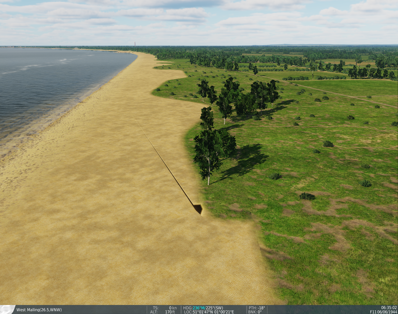
Hi everyone, On most areas of the South Atlantic map (apart from those that are clearly beaches) there's a noticeable sharp incline (75-80°) where land meets water. The incline isn't everywhere and there are some exceptions (namely areas that are clearly beaches, some small rivers etc). An easy way to check is to look at the mission editor/F10 maps - in SAT, if you can see what looks like a thin, grey border (it will be a darker orange/biege in ALT) where the land meets water, there's an incline there. Here's an example, immediately to the south of Pebble Island's grass strip: The main issue with this is it doesn't really look all that natural or realistic - when flying low it almost looks like everywhere is sat on concrete. Though another issue is that player vehicles are unable to climb them (there are of course areas that shouldn't be able to be climbed or landed on, but here it's the overwhelming majority of the land). Perhaps it would be better if there was some 3D rocks, but making the incline closer to 30° would more than suffice. South Atlantic incline.trk
-
Hi everyone, Another very minor issue with the South Atlantic assets - the Mk 46 torpedo has a few errors with it's 3D model compared to the real thing. Firstly, the nose is the wrong shape - the real thing is much more rounded, the one in DCS is almost completely flat: Secondly, there's the propellor, the rearmost one is significantly smaller than the one in front of it, which doesn't seem to be accurate (EDIT in some images the rear most propeller is slightly smaller, but not to the extent as the model in DCS): These are both fairly minor issues but at the same time they shouldn't be too difficult to fix (though the nose might have to be retextured, though the thing is only 2 colours). The other thing is that most weapons in DCS (including the Sea Cat and Sea Dart) have animated control surfaces, the Mk 46 doesn't (all 4 fins on the rear are supposed to be all-moving, not sure what the range is, but I'd say 30-45° is probably about right.
-
Hi everyone, I've noticed 2 issues with the weapon storage areas at RAF Mount Pleasant - one is more minor and cosmetic, the other is more major and does have an impact on actual gameplay. Starting with the latter, very few structures are actually configured as ammunition warehouses for the airbase, compared to the number of shelters/warehouses/bunkers actually present. The much smaller eastern site fairs better, which has 4 out of the 6 bunkers configured as ammunition warehouses (there should be a seventh, but it's not present on the map). However, the much larger western site has none of its storage shelters/warehouses configured as ammunition warehouses - instead only 3 small houses are configured: This means that a single aircraft (say an F/A-18C with 4 JSOWS - half the number it can carry in DCS), can destroy 43% of the ammunition supplies, without taking out any of the hardened shelters, or indeed any of the RL storage shelters. Secondly (and while this is more minor it would have more of an impact if the WSAs were correctly configured), the western site features no revetments, whereas the eastern site does (and having the right layout): Camera position: -camera 74.314641 0.330789 44.788055 -cameradir 0.349447 -0.249392 0.903156 Here's a picture of the real place in Google Earth, revetments are clearly visible: Both sites are otherwise pretty much bang on with object placement, object types and layout, with only a few minor errors (eastern site is missing a bunker, textures are a bit off, there are some objects where there shouldn't be any).
- 5 replies
-
- 3
-

-

-
- raf mount pleasant
- warehouses
- (and 3 more)
-
I accidentally found an error in the scenario mesh. Just wanted to put it on record. The coordinates are in the print. Thanks!