Search the Community
Showing results for tags 'terrain'.
Found 12 results
-
Hi everyone, While playing in Multiplayer I witnessed an S60 firing at me and kept firing even after I completely masked my helicopter. I've created a test mission and confirmed that the S60 will fire regardless of terrain. It will even keep tracking you if you move behind the terrain. I've added a track and miz to demonstrate the issue. Thanks for your help. S60_Ignores_LOS.miz S60_Ignores_LOS.trk
-
 CGTC (Caucasus Ground Textures Compilation) for DCS World Now presenting CGTC, an alternative package to improve the looks of the Caucasus map of DCS World with extensively overhauled ground textures. I've prepared a "READ ME" in .PDF format, also available HERE, with all the necessary info (mod description, installation notes with suggested settings, credits/thanks, etc). Please take a moment to read it before using the mod or posting, as it should clear the most common doubts. Latest 2.84.1 version (release 21/May/2023) represents the biggest update to the mod since the initial release, with lots of changes, some additions and bug fixes. - - - - - - - - - - - - - - - - - - - - - - - - - - - - - - - - - - - - - - - - - - - - - - - - - - - - - - - - - - - - - - - - - - - - - - - - - - - - - - - - - - - - - - - - - - - - - - - - - - - - - - - - - - Now also optional if desired (if you're into that) you have two different options for the Caucasus' Shading Options, which slightly alter overall tones: - Modified based (CGTC uses this one by default) - Original based With the mod installed, go to the main DCS folder and then into "...\Mods\terrains\Caucasus\shadingOptions\CGTC - shading options selection". Use the respective file as of your preference. - - - - - - - - - - - - - - - - - - - - - - - - - - - - - - - - - - - - - - - - - - - - - - - - - - - - - - - - - - - - - - - - - - - - - - - - - - - - - - - - - - - - - - - - - - - - - - - - - - - - - - - - - - - CGTC (v2.84.1) download: https://www.digitalcombatsimulator.com/en/files/3321589/ - This mod was tested and made compatible with newest and also older versions of DCS WORLD (from 2.5 and up), be it Open Beta or Stable releases. - All of the texture replacements have similar format and size as stock defaults, so the performance is identical (both High and Low resolution packages are included). - With no other mod dependencies, install over vanilla (default) Caucasus map of DCS and off you go. - As usual with this type of mod, it can only work in Multiplayer if on servers with “Pure textures” disabled (in the integrity check). And now for the mandatory screenshots.... Enjoy the CGTC mod!
 -
Is there any chance that ED would allow users to make their own terrains? And I dont mean by that the huge static object that pretends to be a map but actually isnt. There already is a thread on similar topic but Im hoping for response from some of the devs if they are planing something like this, considering it or just why not. It would be awesome to have fictional battles around Moscow for example or in the Himalayas. Here is the thread Ive been talking about
-
I did find another topic on this, but it's 6 mos old and seemed like it's stagnant, worried I may not get a reply. I've had Normandy map since it released, I'm wanting to upgrade to the 2.0 map, but when I go to my cart to check out. It gives me a warning message saying. Warning! You already have these products from your cart: DCS: Normandy 2.0 Map Please go back and review added to cart products. Do I disregard the warning, go ahead and pay for it? Is it already installed but sitting dormant in my DCS root install?
-
dcs.logHi All, Hi had this graphics issue on every scenario. On the tarrain or sea a long line with a darkness color, I'll think is a loading issue, but the folder is in a nvme gen4.

-
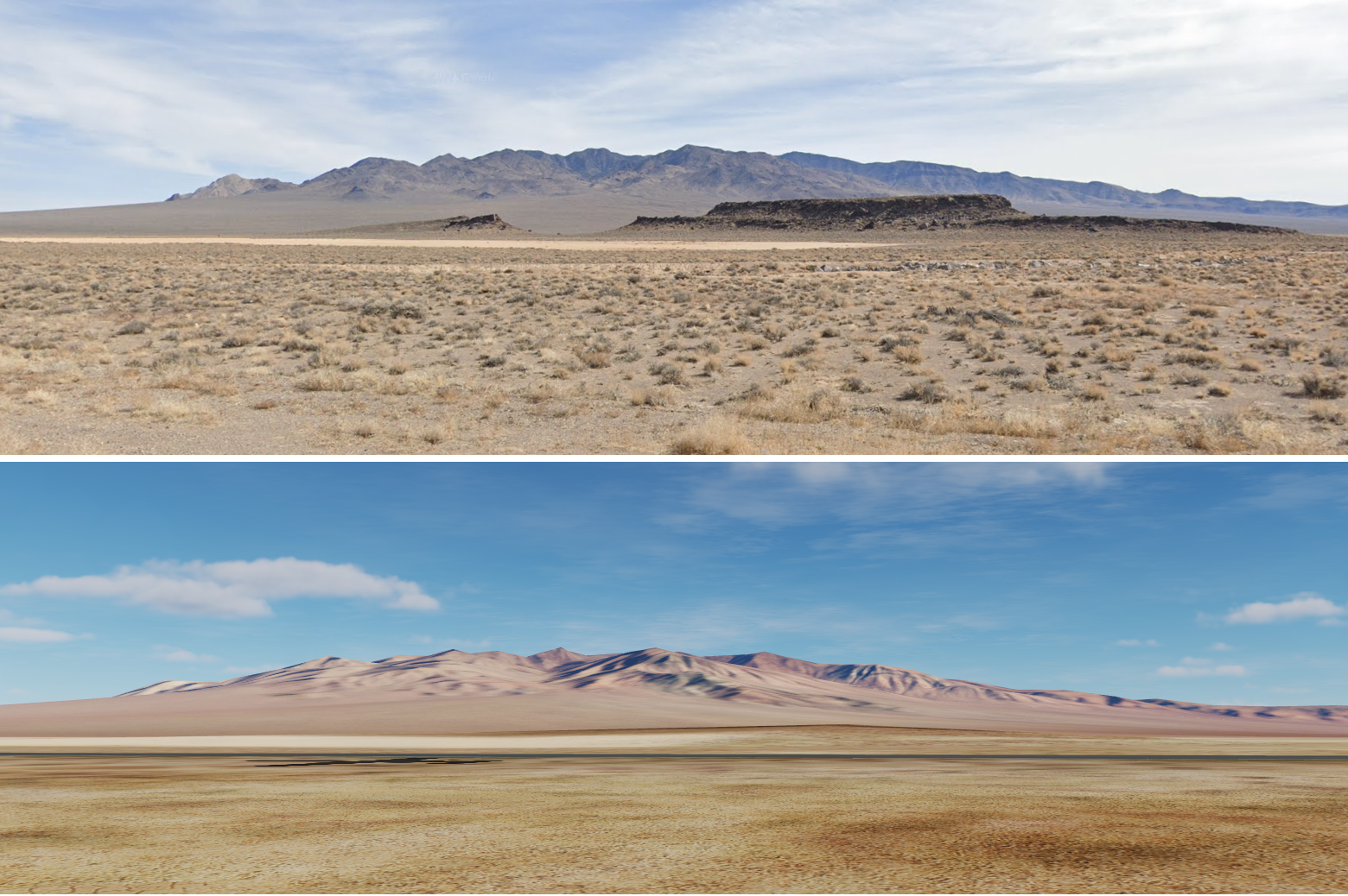
 The map textures are out of anything I see from quality photos (taken from ground/form air). Compare the picture yourselves: Its not a big deal, not a bug, but because of that I feel like something not correct every time I fly a mission on this map. I my say, that I love this map, some more detailed elevation resolution would be very nice, but as long as you not flying low, it doesn't really matter. It seems to me, that someone who took care of NTTR textures has color shifted display tuned for COLD setting. Picture form DCS and Google picture from exact same spot (similar day time): Edited DCS screenshot compare: This is another compare of 60% screenshot with the original one, and small terrain photo in middle.
-
Hi everyone, On most areas of the South Atlantic map (apart from those that are clearly beaches) there's a noticeable sharp incline (75-80°) where land meets water. The incline isn't everywhere and there are some exceptions (namely areas that are clearly beaches, some small rivers etc). An easy way to check is to look at the mission editor/F10 maps - in SAT, if you can see what looks like a thin, grey border (it will be a darker orange/biege in ALT) where the land meets water, there's an incline there. Here's an example, immediately to the south of Pebble Island's grass strip: The main issue with this is it doesn't really look all that natural or realistic - when flying low it almost looks like everywhere is sat on concrete. Though another issue is that player vehicles are unable to climb them (there are of course areas that shouldn't be able to be climbed or landed on, but here it's the overwhelming majority of the land). Perhaps it would be better if there was some 3D rocks, but making the incline closer to 30° would more than suffice. South Atlantic incline.trk
-
I am not sure if this is a bug or DCS terrain engine limitation, but it seems that there is some missed alignment. 33-51-11 N 36-27-30 E
-
Hi everyone, I've found numerous errors and anomalies with the terrain mesh. The one's I've encountered the most are triangular/trapezium shaped sections of terrain, typically presenting around coves, bays and inlets. I've also found at least one massive sinkhole as well as a couple of anomalous ridges. Whilst many of the examples shown below are from low-altitude, they are absolutely noticeable from much higher up (here from a little over 29400 ft): -camera 25.994179 8.972572 -111.347769 -cameradir 0.219616 -0.694937 0.684712 For the meantime, I'll focus on the islands themselves as these are supposedly complete or very nearly complete. It should be said that East Falkland fairs better than West Falkland, though note that the examples below aren't by any means exhaustive. East Falkland: West Falkland:
-
Could you please let us make our own terrain? I have done this on a number of sims many years ago, and it was awesome. You could make it clear that ED has no responsibility for any bugs etc. associated with it. If anyone made a terrain that was up to your standard, you could of course add it to your offered modules. I'm from the south Pacific, it's great flying the other maps, but one of the key attractions of MSFS is the ability to fly over terrain you recognize personally.
-
base on a discord post by dotrugirl, I wonder What are the differences between the current and future develop terrain vs Earth map? 1. what is the business model of Earth Map ? 2. is it going to render on Cloud or any cloud technologies ? 3. What are the key differences in regards to Visual effects? 4. Is it going to use similar damage model and effects? (Flat earth people finally got a point! )
-
Been spending years gaming in Persian gulf and Syria, while Persian is overall FLAT, Syria is fun with canyons, then hows the Sinai? Is it a "Flat" terrain as well?