HotelAlpha
-
Posts
21 -
Joined
-
Last visited
Content Type
Profiles
Forums
Events
Everything posted by HotelAlpha
-
SteelBeasts reaches DCS level easily. The release of version 3.0 is imminent. Check out the screens here (more added every few days): http://www.steelbeasts.com/sbforums/sbgallery/main.php?g2_itemId=17327 Regards, H-A (ex-RL-tanker, long-time SB follower)
-
Solution for me: Deleted entry in my registry: [-HKEY_CURRENT_USER\Software\Eagle Dynamics] Caution when editing your registry! Then re-start DCS and re-enter software key. H-A
-
Hi folks, unfortunately my problem persists. Situation: * own BS1 for years (boxed, German version) * bought BS2 upgrade (English download) when DCS:World was released => AFAIK it worked * after an update of DCS:World (don´t remember which one) I got the $-sign back at the World main menue With the release of 1.2.3 I tried to get BS working again. Measures: * installed of BS2 1.2.3. (English download, required BS1 installed, no prob) * when starting an mission with the shark I get the hardware-code message. There is no work-around for me. My S/N is valid (can check at DCS orders page) and visisting this activation page didn´t help either. Re-installing BS1 doesn´t help, too. Regards, H-A
-
Same problem here. Activation of BS2 fails.
-
@Olgerd: Thanks! @firestick22: LOL! Epic. Greets H-A
-
Thanks, Olgerd! Any word on if that´s real life behaviour? HA
-
Sorry for reviving this old thread, but my question fits here best: When in CCIP mode with DTS as elevation source (DTS shown in the HUD), is the altitude used for the computation of the position of the bomb reticle in the HUD the altitude above ground of the aircraft? Or is does some fancy iteration of the always changing altitude of the aircraft above the computed impact point happen? I believe the first is true, as the bomb reticle moves within the HUD in a way that fits the change of the radar altitude when flying level over uneven terrain. Obviously this can make a big difference in hilly or mountainous terrain... (and yes, I have a basic understanding of the underlying physics and the math, being an mechanical engineer) Regards, HotelAlpha
-
For me it works like Greg wrote. I press ESC to get rid of the briefing scree, then PAUSE to actualy start the mission. Nearly no stutters this way. H-A
-
1. Is easy and a matter of the ME. No problem. 2. That´s what I want them to do. Follow their flightplan until I call them. Possible? BTW: How do I call in CAP?
-
Hi folks, please help me to figure this out. Searching the forums didn´t help. In the ME I made a mini-mission with my A-10C, a Tunguska and a friendly F-16C flight. The F-16s have HARMS, EPLRS active and a SEAD task. Their route is outside the engagement range of the Tunguska. Now I want to call them in on the Tunguska, which I found via TGP and which is SPI. I understand it has to do with p.322 in the manual, but I can´t get it to work. Steps I made: Move TAD cursor to F-16, "SEND" appears, I press "SEND", their network-ID appears. Then I don´t know what to do next. Can´t do "Set the SPI to the location of the TAD symbol that you wish to assign as the target." as written in the handbook. How to do this? Greets HotelAlpha
-
Will new GPU pay off for DCS:A10 with my rig?
HotelAlpha replied to HotelAlpha's topic in PC Hardware and Related Software
Thanks for the info so far! I will try not to buy a new graphics card at the moment but instaid wait for the beta versions to come. Maybe things improve. Regards HotelAlpha -
Hi all! I know, threads like this one are not new, but having read all similiar topics I dare to ask for your opinion. Current system: Core2Duo 3Mhz Geforce 8800GT 4GB RAM Windows 7 64bit DCS:A10 runs fast enough in most situations (I insist on high visibility ranges for landscape and objects, compromise on AA etc. is ok). It gets stuttering when Maverick and (to a lower degree) TGP images are on the MFDs. Do you think it would pay off for me to invest in a GTX460? Or is that nonsense with the current CPU? What do you think, gents? Regards HotelAlpha
-
It works very well, only this little terrain deviation is annoying me. After all, correct positioning of all those hills and valleys is imporant for a groundpounder. Could someone with DSC:Blackshark installed please try if changing the terrain source works? Greets HotelAlpha
-
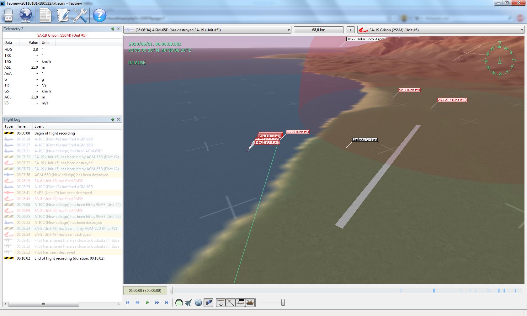
Hi folks! There doesn't seem to be a recent tacview thread, so I dare to start a new one. INITIAL SITUATION: DCS:A10C beta4, Win7-64bit, no DCS-BS installed. ISSUE: Terrain is misaligned. See screenshot, the tanks should be near the runway, not in the ocean. USUAL EXPLANATION: Real terrain used instead DCS terrain. Reason seems to be some misalignment of the DCS terrain to the real world. USUALLY SUGGESTED SOLUTION: In tacview simply change terrain from "Real Terrain" to "Lock-On / DCS". So far, so good. Here starts my PROBLEM: Changing from "Real Terrain" to "Lock-On / DCS" doesn't do anything beyond the terrain graphis redrawn in the exactly same way. MY THEORY: Tacview doesn't have the "Lock-On / DCS" terrain, because it doesn't know that it's installed on my computer. HINT: in the tacview menu with the world icon, there's no "Record [DCS:A10C] flights" entry. Unfortunately, the link on the tacview homepage explaining the DCS:A10C installation is dead. I understand that sub meter accuracy is not in the scope of tacview, but I am sure it can do better than what I get. So, has anybody of you managed to get it to work properly and can comment on it? Anybody has a "Record [DCS:A10C] flights" entry? Regards HotelAlpha

-
Thank you very much! HA
-
Hi folks, I am busy flying The Hog and don´t have BS installed at the moment. Can someone please tell me the loaction of the BS Instant Action mission (name of the city or coords)? Would like to reenact some aspects of the mission with the A-10. Thanks in advance! Greets HotelAlpha