Paletus
-
Posts
17 -
Joined
-
Last visited
Content Type
Profiles
Forums
Events
Everything posted by Paletus
-
Hi there: I made a series of modifications to the lua trying to adjust it as much as possible to reality. Read this post to see if it fits what you are looking for. https://forums.eagle.ru/showthread.php?t=224708
-
Sorry, but i don't know what is you problem and i cann't help you, sorry again
-
Mile indicator ???? I do not see any mile indicator, the only thing you have to see is a black dot on top of the targets that is becoming more visible as you approach them. Send a screenshot, because something you are doing wrong. You have remembered to select in options, gameplay, label options, "dot only"
-
You just need to copy the new labels.lua file into the config / view folder and overwrite the original. Do not forget to make a backup of the original file. Do not change anything in the savegames folder. About the configuration,in gameplay setting you need to have clicked "use this options for all misions" and in the labels setting "dot only" . Of course if you are flying a mission and you disconnect the labels, you will not see the points that mark the objectives
-
New version LABEL.LUA Improvements: Better visibility of targets at medium short distance. Targets appear in a more gradual way. The label (always a DOT) is smaller, adjusting more to reality. Sirrah, the labels are hidden behind the clouds, I think it can not be done, I'm sorry. Please, if someone has any suggestions or ideas that improve the labels, please tell me. Pixel density -1.5, gamma - 2.2 I attach the new file LABEL.LUA. regards Labels.lua
-
Only dot, do not forget to click use this options for all mission, in gameplay options
-
You can replace it, but save a backup copy of the original file
-
I used to make this file the labels.lua of hippo and when I modified any value with the notepad, the labels disappeared, I could not change neither the color, nor the symbol, nothing, until I changed them using the notepad ++. Please Sirrah, tell me what you think of the changes I've made in the labels.lua. If the spotting distance is good, if the targets appear realistically, if you think something should change, thank you I'm doing a new edition of the labels.lua that will have a little more visibility, in a couple of days i upload it
-
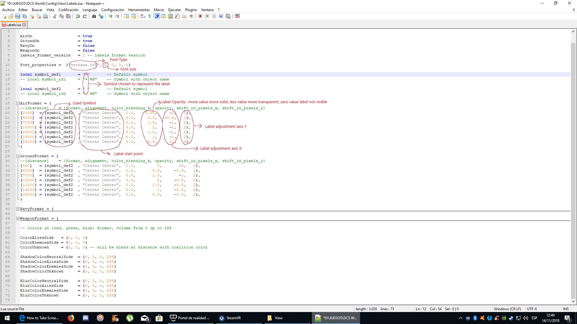
hola: Perdon por mi ingles, estoy usando el traductor de google para hacer este post. Ante todo agradecer por al ayuda a Hippo, que tuvo la paciencia de explicarme el funcionamiento del archivo LABELS.LUA. Aqui os dejo el archivo LABELS.LUA modificado para que la deteccion de blancos en realidad virtual sea mejor, y los targets se puedan ver a distancias mas ajustadas a la realidad. Los blancos aereos funcionan asi: A 23 km (12.5 nm) Se empezara a ver la etiqueta, esta tendra forma de punto, y tendra un color gris muy difuminado, casi no visible A 18 km (10 nm) la etiqueta sera un poco mas visible A 15 km (8 nm) la etiqueta sera medianamente visible A 10 km (5 nm) la etiqueta sera perfectamente visible ,el color sera gris oscuro A 7km (3.5 nm) la etiqueta empezara a no verse, siendo sustituido por la grafico real del avion A 4 km (2nm) la etiqueta casi sera invisible ,pudiendo verse el avion perfectamente A 2 km (1nm) la etiqueta sera completamente invisible Con los blancos de tierra ocurrira exactamente lo mismo, pero seran visibles a menos distancia y la etiqueta sera invisible antes, justo cuando el objeto se vea bien en realidad virtual. Resumiendo, cuando el blanco no sea visible pero empieza a serlo en la vida real, las etiquetas empezaran a verse suavenmente, para despues hacerse mas solidas segun te acercas, y finalmente desaparecer cuando la relidad virtual ya represente el objetivo. Estas etiquetas estan diseñadas para usarse con un Pixel Density de 1.5 y sin usar el virtual zoom. Hello: Sorry for my English, I'm using the google translator to make this post. First of all thank for the help to Hippo, who had the patience to explain the operation of the file LABELS.LUA Here I leave the file LABELS.LUA modified so that the detection of targets in virtual reality is better, and the targets can be seen at more adjusted distances to reality. Air targets work like this: At 23 km (12.5 nm) You will start to see the label, it will have a dot shape, and it will have a very diffused gray color, almost invisible At 18 km (10 nm) the label will be a little more visible At 15 km (8 nm) the label will be fairly visible At 10 km (5 nm) the label will be perfectly visible, the color will be dark gray At 7km (3.5 nm) the label will begin to be unseen, being replaced by the actual airplane graphic At 4 km (2nm) the label will be almost invisible, the plane can be seen perfectly At 2 km (1nm) the label will be completely invisible With earth targets, exactly the same thing will happen, but they will be visible at a less distance and the label will be invisible before, just when the object looks good in virtual reality. In short, when the target is not visible but begins to be in real life, the labels will begin to look softly, then become more solid as you approach, and finally disappear when the virtual reality represents the objective. These labels are designed to be used with a Pixel Density of 1.5 and without using the virtual zoom. Please use to edit Labels.Lua Notepad++,otherwise the changes will not be saved. I also attach a screenshot explaining that it makes each value of the Labels.lua file THX Labels.lua

-
Hello I need some approximate values about the visivility of targets, I do not need that they are very precise. Suppose it is a clear day, summer, on land, and we do not know where the target is. White air: F-18 on collision course, same altitude, tail on. Terrestrial white: M1a2 Abrams, located on a runway or road, tail on. It does not have to be an exact measurement only an approximate measure of when we would begin to see the target in real life, to make it begin to see the label. Thanks again. PD: Sorry for my English, I'm using the google translator.
-
Hello David thanks for the links, I had seen them looking for information to modify the labels. I need some approximate values about the visivility of targets, I do not need that they are very precise. Suppose it is a clear day, summer, on land, and we do not know where the target is. White air: F-18 on collision course, same altitude, tail on. Terrestrial white: M1a2 Abrams, located on a runway or road, tail on. It does not have to be an exact measurement only an approximate measure of when we would begin to see the target in real life, to make it begin to see the label. Thanks again. PD: Sorry for my English, I'm using the google translator.
-
Hola: Estoy intentando hacer unas etiquetas realistas para usarlas en realidad virtual y necesitaria saber unos datos: Volando a 4000 pies de altura en un dia despejado, a que distancia aproximada se veria un blanco terrestre. Y volando a 6000 pies de altura en dia despejado, a que distancia aproximada se veria un blanco aereo. Muchas gracias. Hello: I'm trying to make some realistic labels to use them in virtual reality and I need to know some data: Flying at 4000 feet on a clear day, how far would a pilot see a ground target. And flying at 6000 feet on a clear day, how much distance a pilot would see an air target. Thank you.
-
yes
-
HI: Sorry for my english i'm spanish.I write bad,but understand well. I do a green camo for BS.I change colors,add dirt and mark for the smoke. The file have readme text for install. Some screenshot: The link: http://files.filefront.com/Green+Camo+Skinrar/;12745952;/fileinfo.html I hope you like it Another time sorry for my bad english. THX