Huilque151
-
Posts
128 -
Joined
-
Last visited
Content Type
Profiles
Forums
Events
Everything posted by Huilque151
-
 yes!! i saw the 2003 pictures!! your material its gold.
 -
good observation!
-
Looks like the default "HQ static object" from ED library. thanks for the info!
-
AWESOME WORK! AWESOME WORK! didn't included because i was not pretty sure about the info related to this building on the ODS attacks, thanks for shared! I will included this info and pictures to my PDF.
-
AWESOME WORK! tank for shared!
-
I have added it to the initial report on page one, including several photographs of the moment, but I have prioritized the approach of creating a new post with more information about some of these POIs in importance for the gameplay from my point of view, I will surely dedicate a post to it. What worries me now and I want to be honest is that ED (Nineline or anyone else) has not given any positive or negative feedback other than they will "review" the information, which they posted 1 month and a half ago. ( i think its important to continue this effort and i tell u why) I started this Topic because looking at the map and reading the posts of other users and nineline, I saw that some customers were complaining about the few areas of detail of relevance and I also saw that ninelines asked them for patience and for us to indicate what the POIs are for us, because of that i started this work and Well, here there are POI with luxury and detail, images, exact locations, history and relationship with current conflicts, which would help a lot to make a difference between a map for MSFS and a map for DCS. The truth is I'm a little discouraged by the lack of feedback without considering that it's been almost 2 months since the map was released without any news or new update, the patience that goes hand in hand with trust is created based on communication.
-
thanks a lot for this information! i will be the main info for recreat this mission for sure.
-
@NineLine Hi men! I hope it's very good!! Friend, have you had time to look at the document? In addition to that, this topic was delved into at the IRAQ nuclear research center, perhaps the most important point of interest in all of IRAQ. He has already appeared in several videos by big Youtubers. Please tell me, if this work and the one I am continuing is interesting for the map development team, it would be a great motivation to continue collecting information and images of other points of interest. PD: in the Next post will going in deep of The Al-Mamoun Solid Rocket Motor Production Plant related to the production of ballistic missiles launches from SCUD. A huge target!!!
-
Thank u bro!
-
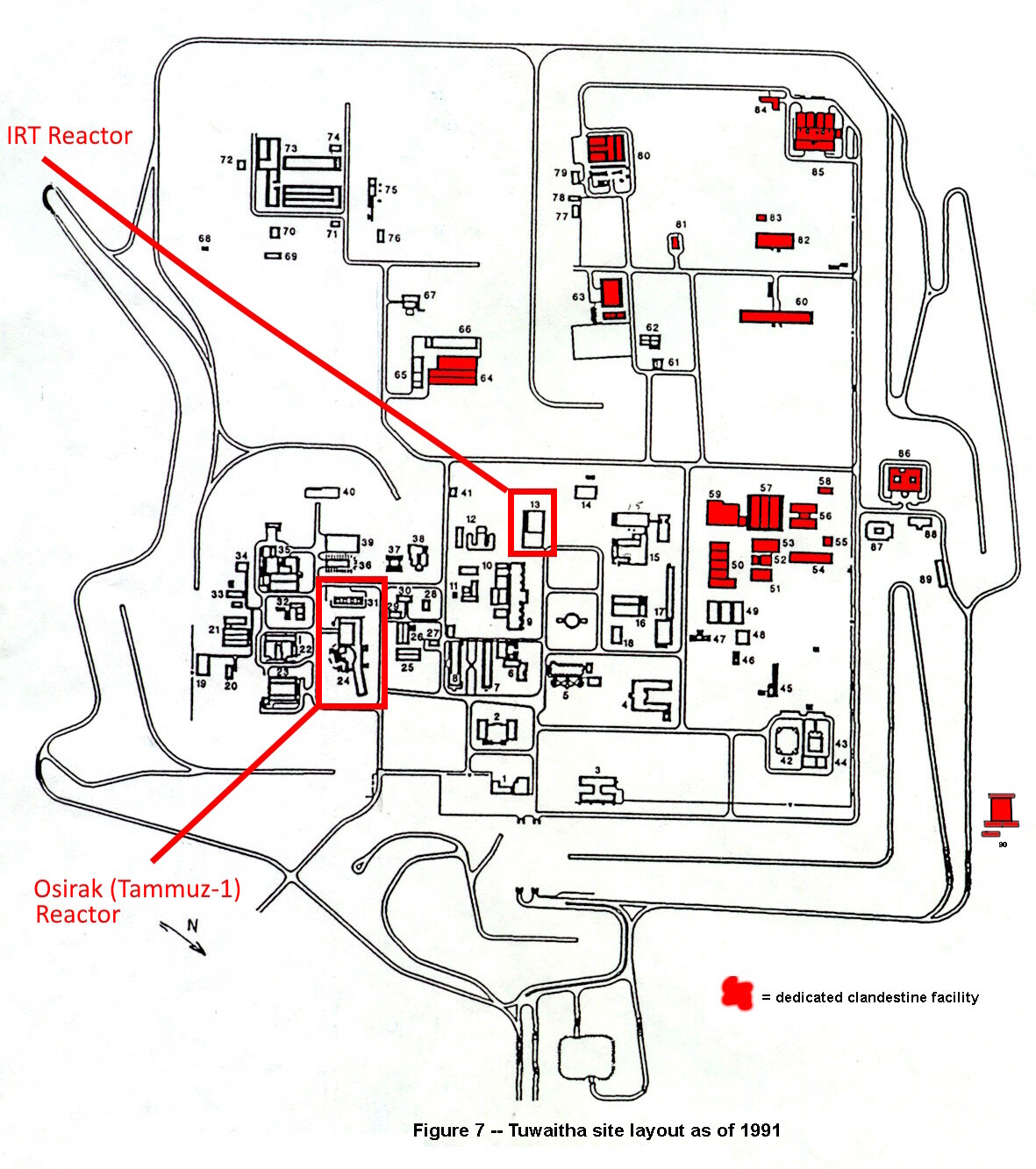
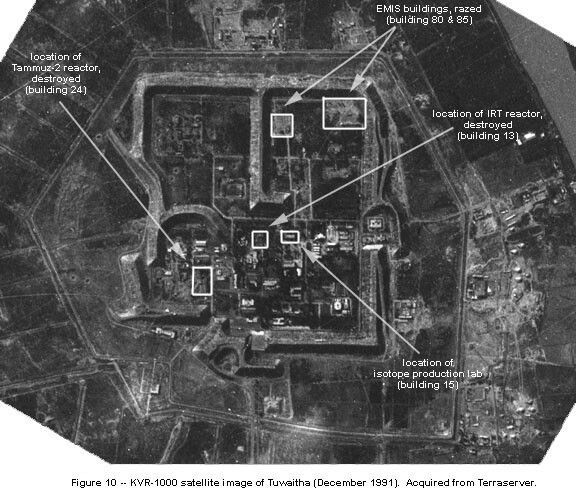
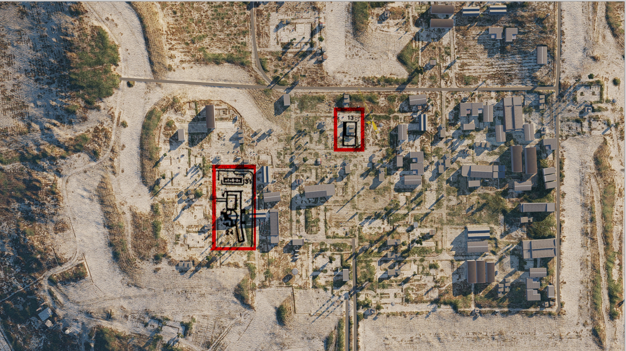
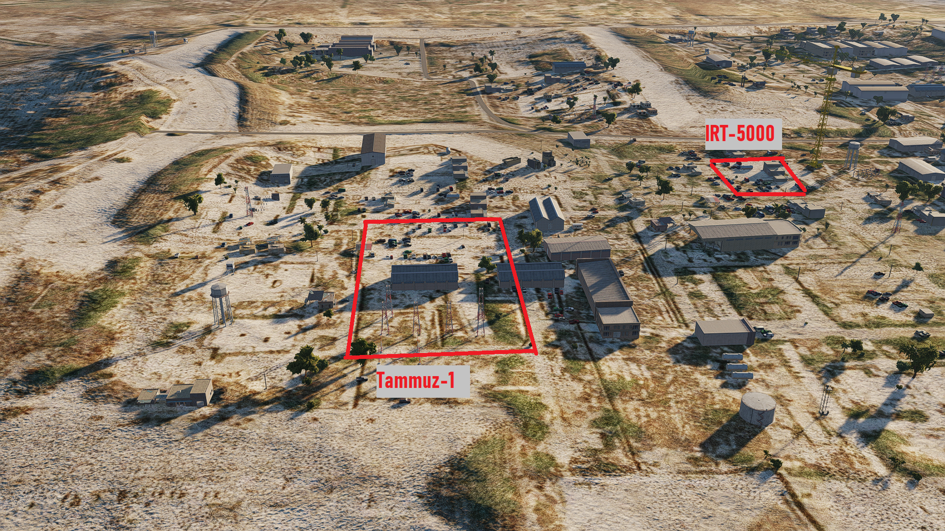
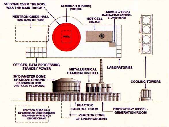
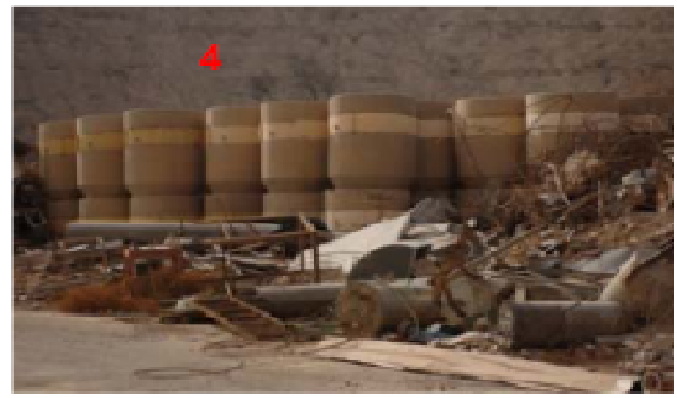
1. - ONE OF THE MOST IMPORTANT POINT OF INTEREST: The Al Tuwaitha Nuclear Research Center The Al Tuwaitha Nuclear Research Center, located 18 km southeast of Baghdad, was the main site for the Iraqi nuclear weapons program. Al Tuwaitha facilities cover over one square kilometer and included two research reactors (Osiraq and IRT-5000), a fuel fabrication facility, facilities for plutonium separation, uranium enrichment and other purposes. The Osiraq reactor was bombed by Israel in 1981 and the IRT-5000 research reactor was bombed by the U.S. during the Gulf War. Other facilities were damaged or destroyed during the Gulf War. Additional facilities at Al Tuwaitha were damaged or destroyed during Operation Iraqi Freedom and subsequent looting. Most distinctive buildings: Osiraq Reactor ( Tammuz-1): The French had agreed to supply a 40 MWth MTR reactor called Tammuz-1 or Osirak, a zero-power reactor called Tammuz-2, a materials testing hot laboratory (named LAMA), workshops, and a radioactive waste treatment station (named RWTS) IRT-5000 nuclear reactor building 13: The IRT reactor. This facility also contained offices for the physics and chemistry departments. An extension in front of the reactor building was completed in about 1970 to house the new IBM mainframe computer which was installed in 1973, and to house part of the Physics Department. The reactor was upgraded in 1978 to 5 megawatt-thermal. Okay, let's get it straight. -------------------------------------------------------------------------------------------------------- I think the first thing that makes this place very characteristic is its defenses built on giant mounds of earth. Furthermore, it requires pilots to carry out very well-planned use of weapons, by other hand i could say that the Tammuz-1 reactor is the most important and iconic building in historical and cinematic terms inside the complex. We have already been able to see the videos of Grim reapers Bombing this reactor in their Operation Opera video, perhaps the first video made on the new map of Iraq. Also this building its particularly different and unique (Important for 80´s visual bombing). I will add a sequence of images that shows the place where both reactors were, in addition to images where you can see drawings and diagrams of the Tammuz-1 reactor building and real images of what it looks like today. i so sorry at this moment i dont have images of IRT-5000 Reactor. If somebody have pictures, please shared. Finally i will shared the images of others building around the Tammuz-1 reactor like the radioactive waste treatment station named RWTS, (ID 1, 2, 3 red numbers) I will continue on the next post. Sources: https://isis-online.org/isis-reports/detail/development-of-the-al-tuwaitha-site-what-if-the-public-or-the-iaea-had-over/9 https://www.nti.org/analysis/articles/iraq-nuclear/ https://www-ns.iaea.org/downloads/rw/projects/iraq/documentation/wm07paper.pdf Operation Opera F-16 Hud tape:

- 52 replies
-
- 14
-

-

-
yes sir! actually i already a member. I waiting the file tu put the AB on the map and replaced the Normandy map with the iraq map jejej thanks regards!
-
@NineLine Hi bro, i hope the F-35 discussion get cold! Man, Have you been able to see or share my document attached to the beginning of the thread? greetings
-
F-35A Announcement discussion mega thread.
Huilque151 replied to LimePartician's topic in DCS: F-35A
Leyendo los comentarios, desde mi opinion personal creo que se debe aumentar la diversidad de REDFORCE de 3 y 4 ta gen antes de pensar en REDFORCE MODERN: MIG-25 FF MIG-23 FF SU-24 FF Ya que tenemos BLUE FORCE ( F/A-18C, F-16C, F-15C/E) para combatir esa REDFORCE. Por otrol lado aumentar a la par los S2A system con sistemas de mediano a largo alcance Chinos o el desarrollo del S-350, que inicio operaciones el 2009 ( dentro del periodo de la decada de los 2000; al igual que F-16C block 50, F/A-18C 2007, F-15C anunciado entre 2000 y 2010). En lo ideal aumento de unidades navales de otros paises de la REDFOR. desde mi punto de vista el F-35 abre la puerta a la 5ta GEN pero creo que antes de construir una arquitectura de sistemas y ambiente para misiones 5ta gen se debe poder haber hecho lo mismo con 3-4 gen. -
F-35A Announcement discussion mega thread.
Huilque151 replied to LimePartician's topic in DCS: F-35A
Dont Worry dude! It must be a crazy day for you, you had a lot of action today! I'm encouraged and I would love to be someone who knows the F-35 well enough to be able to share data, if I know friends who have spent years reading about the plane. Greetings! Could you see my post and PDF about POI in IRAQ MAP / DESERT STORM ??? I know this week is crazy for you, please tell me if you have been able to see it, much success with the new projects! -
F-35A Announcement discussion mega thread.
Huilque151 replied to LimePartician's topic in DCS: F-35A
Hello ED, first of all the 2025 & Beyond video was incredible, the DCS cinematics are getting better every day, the F15C Announcement was what I expected even though I didn't see it coming! and the announcement of the F35 wow!! But a few seconds after the excitement, doubts begin. For those of us who have read the Forum, we have constantly read that more technical and public information is needed for the development of some "WISHLIST" aircraft. As a result of that, many of us thought, Well! It seems ED is very responsible in carefully filtering the information, for us that assumed by us, it is a consolation that ED does the right thing although we cannot have the modern modules that we expect but we will have a more realistic full fidelity Simulator that we can have outside the military world and that would be above others like WT. The presentation of the F-35 creates this great doubt, especially when the methods of how the information will be obtained are reported. start the questions? Will DCS develop modules based on public documents from unofficial sources? If so, why not EA-18G Prowler? An S-400? an F/A-18E? because there are many open source articles from unofficial media and they are very good, surely enough to start a project. And another question perhaps the most worrying, ED has decided to make ¿Realistic modules or the most realistic that we can access as civilians?, because there is not much competition, so make a module with very little information or with gaps, which results in a module far from what it tries to represent even that can result in the "The most realistic thing there is in the civil environment." Finally, when forum users talk about the standard, they are referring to this, and as the word says, the "standard" should not change according to the project, if it does not stop being a standard. I hope you don't take my post wrong, I'm not a heater, it's just that there are a lot of doubts, but I'm sure that ED knows all this and that they will professionally address these challenges. I wish you the best in this gigantic project!! I wouldn't expect it before 2030 so I see it far from the horizon and I'm not always worried, especially if it allows us to experience the capabilities of a 5th generation module and not a 3D model of a 5th generation aircraft without the capabilities that make it a 5th gen. Regards!!! -
Thank u !! man!
-
Hello friend, I couldn't tell you what exercise that photo is from, but I can tell you that those F-15C (Tail code EG) are from the 33d Tactical Fighter Wing (Provisional) Deployed from Eglin Air Force Base, Florida Headquarters to King Faisal Air Base, Tabuk, Saudi Arabia, Unfortunately, that base and the Tabuk region (and city) are outside the limits of the map. Regarding the exercises performed and the training areas; I can share an image with you and also tell you that during desert shield they did a lot of exercises, being the biggest one; the Internal Look exercise. In volume IV of the power survey you can read about the training of the coalition. greetings! AFD-100927-066.pdf
-
I was looking for this place for a long time and I reached more than 1 place that in some cases was a point without a trace of anything in the middle of the desert, according to some reference points indicated in some videos, the flight hours and the flight speed . , the place is around what is indicated in the image. If you ask me, where the pins are, they are places very similar to those seen in the images of the Apache Gunners and comply with the flight distance. In the red triangles I once saw some references to where they we null
-
@cementerio4DCS This info its awesome!! Very impressive work! @Nueve líneas !! please considerate see this work. Thanks bro.
-
Awesome tool dude, thank for sharing! i will shared mi work on a desert shield.miz regards! Hi Vampiro, there its the PDF again. DCS IRAQ MAP - Puntos de interes (Español).pdf DCS IRAQ MAP - Suggestions and points of interest (English).pdf DCS IRAQ MAP - Sugerencias y puntos de interes (Español).pdf ANEXO #1 pictures of POI V0.1.pdf
-
Cool! please shared your progress! will be awesome can talk about Desert Shield! regards!
-
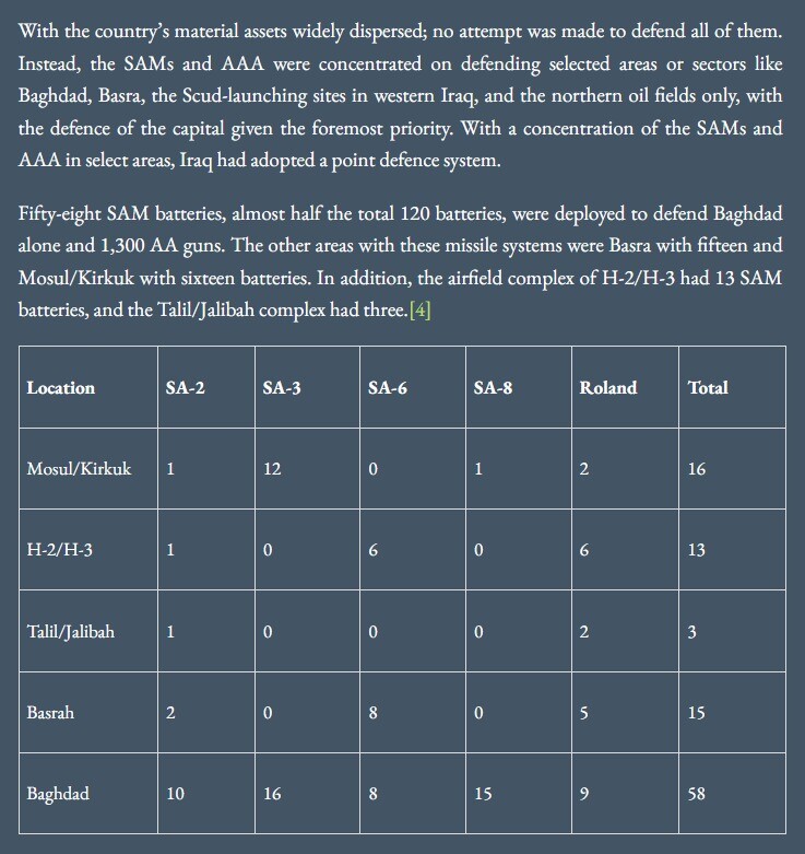
Thanks, I'll look! Currently I was able to read some volumes of Power Survey 1993 (Operation Desert Storm Debrif document) that shows the areas covered by airdefenses and the SAM and AAA used by IRAQ in those areas, as well as other documents on the web that illustrate the same, but in could not find satellite images or some specific coordinates. Using the historical tool of Google Earth, I was able to see very clearly some possible SAM sites, some occupied by SA-2 and others possibly by SHORAD (probably SA-9) but regarding ODS, after of 11 years and a war where they lost many large anti-aircraft systems, it is very difficult to find vestiges of SAM sites (although there are several places where it seems so) but it is very difficult to confirm it with responsibility, therefore, I only mentioned it in the document without specifying positions, anyway I think it is just as great to be able to represent the density, types and scope of area covered by SAM and the real location in which it was Perhaps it becomes secondary, that's why my recommendation is to increase the static objects that allow us to create realistic SAM sites, rather than having ED put a SAM site on the same Map. Friends, if you are interested I can upload the information I have about that in addition to a static template that I am uploading with the air defense sector 1 (Proximities of BAGHDAD). I share a little bit of what I'm working on. Greetings!!
- 52 replies
-
- 12
-
-
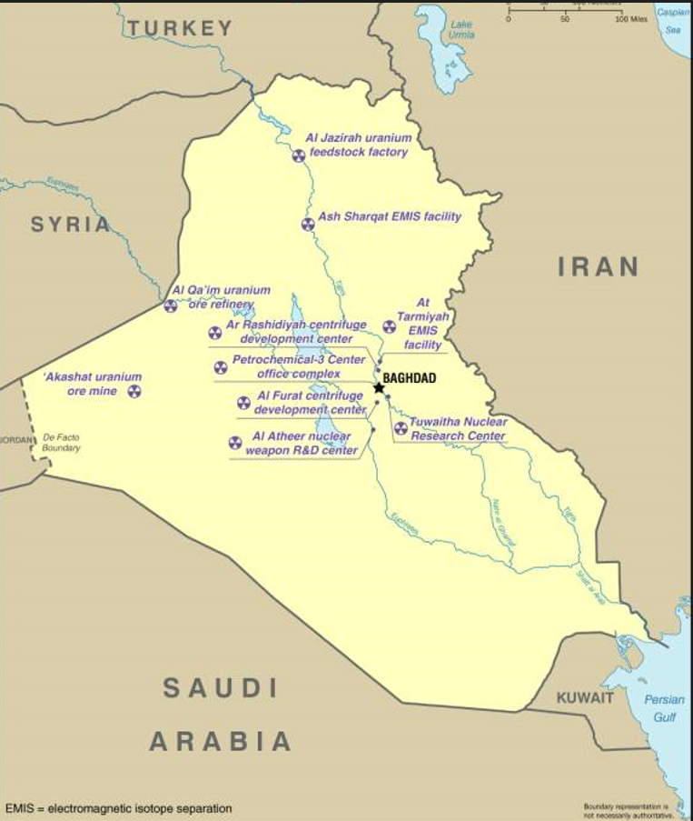
Hi! This its a list forty POI related to 1991 (mainly) wulf war conflict. If somebody want to see the full document with pictures & google earth file (exportable to CF) please follow this link. Please helpme to shard this with ED and de development teams, regards! Leadership & command facilities. 1. Royal Saudi Air Force Center (CETCOM installations) - Riyadh city. 2. KSA Ministry of Defense (CETCOM installations) - Riyadh city 3. Al Jahrah IOC & CP area (Intercept operation center), Kuwait, N 29 23.450 E 047 37.390 4. 5th Air defense sector operation center), Al Salem, Kuwait, N 29 21.050 E 047 38.300 5. Ministry of Defense, Baghdad city. N 33 20.681 E 044 22.902 6. Al Salam Palace (republican guard HQ), Baghdad city - N 33 16.697 E 044 23.981 7. Palace former regime president (Ancestral Hussain house),Kitrit N 34 35.396 E 043 41.866 8. Ba´ath Party HQ, Baghdad - N 33 18.066 E 044 22.962 9. Tharthar Presidential palace: N 33 43.265 E 043 29.373 - (2003) 10. Saddam Presidential VIP Facilities: N 33 43.226 E 043 31.674 (2003) 11. Iraq intelligence service 1991 HQ.(Replaced today) N 33 18.551 E 044 21.465 Nuclear, Chemical, Biological & conventional weapons facilities. 12. FAC Missile storage N 29 21.050 E 047 38.300 13. Al Tuwaitha Nuclear Center, N 33 12.380 E 044 31.136 14. Al Furat Manufacturing Facility, - N 32 45.142 E 044 16.918 - (2003) 15. Al Fullaj II Clorine and phenol plant - N 33 28.349 E 043 43.558 (1991 - 2003).i think 16. AL Fallujah III castor oil extraction plant - N 33 28.561 E 043 39.771 (1991 - 2003) 17. Abu Ghurayb (CW facilities) "Baby milk factory" - N 33 18.346 E 044 10.807 (1991) 18. Al mamount solid propellant plant 33°01'10"N 44°13'10"E (1991 - 2003) 19. Al qaim Superphosphate Fertilizer Plant - N 34 19.451 E 041 10.836. 20. Khamisiyah ammo storage complex - N 30 47.670 E 046 24.308 Communications facilities. 21. Baghdad telecom center (Bag TWR) N 33 18.194 E 044 21.256. 22. Umm al Aish, SATCOM, Kuwait. N 29 26.850 E 047 41.128 Naval Facilities. 23. Al Basrah Naval Base A HQ 1991 (Today destroyed ) N 30 33.227 E 047 48.474 24. Umm Qasr Port Facilities (Warehouse attacked on 91, last picture 2018) N 30 01.796 E 047 56.990 Oil facilities. 25. Al Basrah Petroleum Refinery in Iraq - N 30 27.480 E 047 39.650 26. Baiji Oil Refinery - 35° 0'26.86"N 43°30'1.80"E 27. As-Samawah Petro Refinery South- N 31 14.748 E 045 15.395 28. K3 Pumping Station, Near Hadithah - N 34 04.132 E 042 20.947 29. K1 pump station: N 35 30.773 E 044 18.527 30. K2 pump station N 34 54.812 E 043 24.870 31. K3 Pumping Station, Near Hadithah - N 34 04.132 E 042 20.947 32. H-1 Pump station and POL N 33 47.360 E 041 27.663 33. H-3 Pump station and POL N 32 56.876 E 039 43.954 34. Burned Kuwaiti oil fields area center point N 28 58.796 E 047 59.437 Power plants facilities: 35. Al Musayyib TPP N 32 50.574 E 044 16.491 36. Baghdad TPP N 33°17'22.02" E 044°27'9.74" 37. Salah al din TPP N 34° 5'18.49"N E 043°58'33.65" 38. Al Mawsil Power station. N 36°18'58.89" E 043° 1'27.11" SCUD facilities - H2 Airfield N 33°21.952' E 40°35.057' - H3 Airfield N 32°55.817' E 39°44.774' Note* i dont have the precise position of this scud site but i can recommend it being modeled around the H2-H3 Airfield. I added a picture of how Scud storage bunkers, rearm point and trench look like in 1991. Bridges and rail yards facilities. 39. Baghdad Railroad yard N 33°19'30.92" E 44°22'48.10" 40. Al Zubayr Railroad yard N 30°28'29.58" E 47°39'16.53
-
Hi @NineLine, @marktuner1960, and guys especial Desert storm conflict fans. First of all, this its not a not happy client post, i love this map, i was waiting for it meaby for 5 years and i spend a lot of time (truly a lot) rejoin this information, i hope useful for the development team and to the mission editors reading this topics (Please help me to shared this file with the development team). Alright! this PDF include information, images and locations of:: 14 Coalitions main airfields on Saudia Arabia. US Navy & US marines corps land deployment airfields, FARPS locations and CV stations on sea. 34 Iraqi and Kuwait major airfields and major FLOs targeted by coalitions during ODS. 40 Points of interest related to: Coalitions leadership and command. Iraqi leadership and command. Iraqi Nuclear, Biological, chemical and conventional weapons facilities. Iraqi communications facilities. Iraqi Oil facilities. (Included related to Kirkuk - Haifa oil pipeline; Backbone of Iraq oil industry) Iraqi Power plants. Iraqi Naval and port facilities. Iraqi Rail yards and Bridges. Area of interest. SCUD launch zones. Kuwait burning oil fields field. Ground war and aerial support operations area. Static objects related to Air defense and Scud. Suggestions and finals word. attached files: the English & Spanish version of this PDF. Google earth KMZ file (recommend used the Historical image tools) A few of POI structures doesn't exist today.) SUGGESTIONS & FINALS WORDS. Westerns Coalition airfields. The Airspace available on this map its huge, i really glad of that, but, almost the 25% of the airspace its not operational usable, because, the only Easter disposition of the coalitions airbases will force fly only north west to reach the North and South Iraq and Kuwait. To allow the use of that airspace i will suggest add westerns Airbases or airfield even if that include a map expansion ( in some alternatives to west or only a little to south. Including the bases of Riyadh AB, Al Kharj Air base, King Faisal AB in Tabuk and Al-Jouf FOB (Task force normandy deploy FOB). If that its not possible pleas considerate to add the city of Medina and its Prince Mohammad Bin Abdulaziz Airport. , model the city of Riyadh and its air base and the Al Kharj Air base and Al-Jouf FOB. Detailed modeling of POI and AOI. Performing detailed modeling of the recommended POIs, especially Nuclear, CW and BW, and increasing static objects for the simulation of SAM and SCUD Sites would give a positive and significant impact to the IRAQ map, especially since many youtubers and gamers They recreate and will recreate their missions and videos on this map based on conflicts where operations were mainly visual (CCIP Bombing, LGB Bombing with TGP, Low level Interdiction, CAS, CSAR, etc.) where the detail in the objectives to attack and also the detail of the environment such as changes and esplanades is important in some specific areas mentioned above. Increase Static Objects and fire effect. We recommend making a complementary IRAQ ASSET PACK or simply adding new static objects to set the missions that we will carry out in IRAQ MAP with greater precision and detail. The statics related to SCUD and anti-aircraft defenses (Similar to SAM site assets pack) are especially important. Also please considerate make more bigger (10.000 & 20.000 ft vertical size of the Smoke and fire effect) to recreate the huge smoke column of burning kuwait oil fields. I hope this document will be helpful to the development team in the development of the map and to my virtual pilot colleagues who develop missions on this map. I Hope everyone are having a nice holidays. ------------------------------------------------------------------------------------------------------- Attached# 1: PDF with more than 80 images of POI & AOF. Google Earth KMZ File with POI, AOI & Airfields locations, images and aircraft deployment info. (Exportable to CF) DCS IRAQ MAP - Suggestions and points of interest (English).pdf DCS IRAQ MAP - Sugerencias y puntos de interes (Español).pdf ANEXO #1 pictures of POI V0.1.pdf Operation Desert storm v 0.1.kmz
- 52 replies
-
- 34
-
-
-
IRAQ MAP - 1991 DESERT STORM - POINT OF INTEREST, IMPORTANT AREAS, STATIC OBJECTS AND SUGGESTIONS. Hi @NineLine, @marktuner1960, and guys especial Desert storm conflict fans. First of all, this its not a not happy client post, i love this map, i was waiting for it meaby for 5 years and i spend a lot of time (truly a lot) rejoin this information, i hope useful for the development team and to the mission editors reading this topics (Please help me to shared this file with the development team). Alright! this PDF include information, images and locations of:: 14 Coalitions main airfields on Saudia Arabia. US Navy & US marines corps land deployment airfields, FARPS locations and CV stations on sea. 34 Iraqi and Kuwait major airfields and major FLOs targeted by coalitions during ODS. 40 Points of interest related to: Coalitions leadership and command. Iraqi leadership and command. Iraqi Nuclear, Biological, chemical and conventional weapons facilities. Iraqi communications facilities. Iraqi Oil facilities. (Included related to Kirkuk - Haifa oil pipeline; Backbone of Iraq oil industry) Iraqi Power plants. Iraqi Naval and port facilities. Iraqi Rail yards and Bridges. Area of interest. SCUD launch zones. Kuwait burning oil fields field. Ground war and aerial support operations area. Static objects related to Air defense and Scud. Suggestions and finals word. attached files: the English & Spanish version of this PDF. Google earth KMZ file (recommend used the Historical image tools) A few of POI structures doesn't exist today.) SUGGESTIONS & FINALS WORDS. Westerns Coalition airfields. The Airspace available on this map its huge, i really glad of that, but, almost the 25% of the airspace its not operational usable, because, the only Easter disposition of the coalitions airbases will force fly only north west to reach the North and South Iraq and Kuwait. To allow the use of that airspace i will suggest add westerns Airbases or airfield even if that include a map expansion ( in some alternatives to west or only a little to south. Including the bases of Riyadh AB, Al Kharj Air base, King Faisal AB in Tabuk and Al-Jouf FOB (Task force normandy deploy FOB). If that its not possible pleas considerate to add the city of Medina and its Prince Mohammad Bin Abdulaziz Airport. , model the city of Riyadh and its air base and the Al Kharj Air base and Al-Jouf FOB. Detailed modeling of POI and AOI. Performing detailed modeling of the recommended POIs, especially Nuclear, CW and BW, and increasing static objects for the simulation of SAM and SCUD Sites would give a positive and significant impact to the IRAQ map, especially since many youtubers and gamers They recreate and will recreate their missions and videos on this map based on conflicts where operations were mainly visual (CCIP Bombing, LGB Bombing with TGP, Low level Interdiction, CAS, CSAR, etc.) where the detail in the objectives to attack and also the detail of the environment such as changes and esplanades is important in some specific areas mentioned above. Increase Static Objects and fire effect. We recommend making a complementary IRAQ ASSET PACK or simply adding new static objects to set the missions that we will carry out in IRAQ MAP with greater precision and detail. The statics related to SCUD and anti-aircraft defenses (Similar to SAM site assets pack) are especially important. Also please considerate make more bigger (10.000 & 20.000 ft vertical size of the Smoke and fire effect) to recreate the huge smoke column of burning kuwait oil fields. I hope this document will be helpful to the development team in the development of the map and to my virtual pilot colleagues who develop missions on this map. I Hope everyone are having a nice holidays. ------------------------------------------------------------------------------------------------------- Attached# 1: PDF with more than 80 images of POI & AOF. Google Earth KMZ File with POI, AOI & Airfields locations, images and aircraft deployment info. (Exportable to CF) Operation Desert storm v 0.1.kmz DCS IRAQ MAP - Suggestions and points of interest (English).pdf DCS IRAQ MAP - Sugerencias y puntos de interes (Español) (1).pdf ANEXO #1 pictures of POI V0.1.pdf


.jpeg.d4934fc2db44968d40ce5c6c0edd9c64.jpeg)