

Fri13
-
Posts
8051 -
Joined
-
Last visited
-
Days Won
4
Content Type
Profiles
Forums
Events
Posts posted by Fri13
-
-
9 minutes ago, RealDCSpilot said:
It's coming today:
Damn.... There went my couple days....
I have been focusing to one of the projects and totally lost idea of the what day it is. I was like it was 9th and then I read yesterday that ED had is going to "have meeting today that are they good for release on 16th". And I was like "Wow, release at the end of the week, cool".
And then couple hours later I had notification on phone that said "You have scheduled meeting tomorrow 16th...." And I was like WTF?! Mi-24P might get released today!
And now it is official?
-
 1
1
-
-
5 hours ago, Eldur said:
Great idea to have such a chart, but with those colors against a white blackground with very little contrast, it's practically illegible.
I had first the MCG Pro as background and f text had shadows, but decided remove it from public as people has different joysticks and it doesn't do good anyways.
I make small edit for it.
-
1
-
-
This is great how much they have developed map further.
I hope to see some future additions when tech gets better (like more clutter etc).
-
1
-
-
56 minutes ago, jym said:
Wags' latest video on using Hind ATGMs might give you an idea on how to split up the commands.
I made that from it.
There is many ways how those can be visually presented, but question is that when it becomes too confusing when you have in reality one hat and you present it as two (operator + pilot) or three (operator + pilot + observation) hats?
Easier is most often such case just have one hat as physical and then separate only the long and short, and separate the modes by colors.
But if someone has better idea...
Example the wording could be changed that what the Petrovich is to do.
"Player in operator cockpit" -> "Petrovich is pilot"
"Player in pilot cockpit" -> "Petrovich is operator"
That can make things easier for someone, and more difficult for someone else.
Like I changed the Left Short as "Visual Heading Turn" because you as player are commanding the new heading visually looking at that direction. Something that Wags called "Chevron Icon".
Wags uses "Command Heading" where I called it "Command Compass Heading Left/Right" as you are telling a specific compass heading to fly, and you select which direction you want to move the virtual HSI to select your wanted compass heading.
-
1
-
-
26 minutes ago, MAXsenna said:
Thanks Fri! Gonna print it out and put it next to my screen!

Before possibly wasting ink, wait that if someone finds some errors or better wording.
Example I don't know is it better say "IAS Up" or "Speed Up" or something...
Or should the pilot and operator seats be separated by the different sets, instead all joined to one set?
-
1
-
-
1 hour ago, Lurker said:
Another thing, it looks like that as soon as the missile hits Petrovich "forgets" all about the target site, so you have to go through the whole procedure again? Or is it enough that I simply select another target from the menu, and he will fire on that target?
I would like to see that as long the Petrovich is "in observe mode" (Up Short) then as long it keeps scanning the targets in the area. After destroying one, it should automatically show again the list for player to choose from.
If not so, then maybe Up Short again commands such list to appear? As I don't see reason why Petrovich should be called OUT and then back IN to search the area....
Considering that you want to engage one target, maybe second and then go around for a new attack run. You don't want to have to find the combat area again and AI should know where it was (he is responsible for navigation as well!). And when you get heading again inside +/-60 degree for re-attack, you should get list again.
What I saw odd in the Wags video was that when he commanded Petrovich to go in Observe Mode and Wags explained how it takes some time for it to find the targets. I assumed that you would see the CCIP pipper move across the area.
So first a delay that Petrovich changes the position and gets eye on the sight.
Then see the CCIP pipper moved to the area.
And see the CCIP pipper move a few seconds across vertically and horizontally scanning the area for targets and then list them.
But maybe that is what was shown. Petrovich spotted immediately few targets once the CCIP pipper moved on the area and decided not to scan more?
https://youtu.be/jtzLUCO-KfU?t=736
Later on one can see that Petrovich starts moving CCIP pipper up on the horizon
https://youtu.be/jtzLUCO-KfU?t=825
-
2
-
-
31 minutes ago, Lurker said:
This is another weird point. Why would this damage the sight? I can't think of a logical reason why they would make the sight susceptible to damage from own-ship maneuvers?
I think it could happen if you maneuver too hard and you collide the stabilized sight on its gimbal edges.
Similar thing is with the AV-8B Harrier (not modeled by Razbam) that if you do not apply power to the DMT (as some people recommends that so you don't mess with it when using TPOD) then the DMT gimbal is not locked in place and it moves freely. And if you maneuver you can damage the DMT gimbal itself even when it has some rubber/flexible dampeners around it.
So in normal flight it should survive without power, but better be safe and power it so DMT gimbal is locked in place.
I think that similar is with that.
As after all that sight in Mi-24 is from a tank (can be from IFV or MBT, don't remember that), and it is locked in place aligned with the gun, and is required to be stabilized only by the turret two-plane (vertical and horizontal) movements. So there is no where such gimbal limits there as it is now in helicopter.
And that has likely been one of the pain in the butt for Mil designers that they were not allowed to develop a custom own sighting system for Mi-24 but were ordered to use existing periscope from the army. So how do you make a +/- 60 degree stabilization with +/- 60 degree roll stabilization work when no ground vehicle would ever be subject for such?
So they managed to make a complex gimbal for bottom of the fuselage and stabilize it with such huge range and that can be such that you have some limits there if you hit too hard there.
But, remember that the system is designed so that once you reach the gimbal limit, the sight will reset to boresight. But that likely in normal flight conditions and not when pilot like now the Petrovich did that it makes hard turns, bleeding speed while doing so. Like look at the Wags commanded "hook turn". From about 300 km/h speed Petrovich consumed 150 km/h for turn. So there is tweaking to be done that Petrovich would not be so hard handed to perform the turns, but try to make them smoothly. I think that needs to be done relative to the distance or amount of corrections. Like if you want to do a 5 degree correction, don't wave the cyclic around to do it, but do it smoothly. If it is 90 degree "visual turn" (left short) and player looks closer, then perform tight turn as it is almost as "Enemy there! Under kilometer" instead "Enemy 3 km at 3'clock" where smooth turn would make sense.
-
1
-
 1
1
-
-
Latest version, added all missing parts, thanks to Bailey to link the ED released quick guide.
This should be a kneeboard size.
Interesting thing is that there is no "Translate backward" when in Hover Transition (purple). Instead you are only offered to perform a 180 degree evasive turn. So you can translate to left/right/forward and give a visual heading turn, but not move backward.
-
12
-
7
-
-
47 minutes ago, Tank50us said:
And sadly, this is a matter of physics in play, and physics does not know what mercy is.
I am so going to steal that from you....
 47 minutes ago, Tank50us said:
All that said however, as I've said before, people think that submarine simulators would be cool, until they play them and find out that they really aren't. Cold Waters is a pretty good simulation as it does make things easy to understand and does some of the hard stuff for you (like IDing sonar contacts), but at the same time, it's not exactly a game known for its heart racing action. After all, if things get interesting, you screwed up somewhere. For example, a perfect attack on a convoy should result in the ships you fire on never knowing you were even there to begin with until things start blowing up.
That is true that DCS would never be able simulate a submarine to real level. Just impossible for any game ever because you have hundreds of men doing their own stuff and couple dozens are critical for combat procedures phases. So two player aircraft is so much easier to simulate.
But let's face it. If Cold Waters or Dangerous Waters would be implemented to DCS World, there would be lot of players for those ocean tasks. We would suddenly need a lot bigger sea maps. Those games does very good job for adding enough simulation of the submarines, surface ships and their operations that it doesn't need to go deeper than that really.
Similar is with the RTS community for ground warfare, where we might have Combined Arms for the individual vehicle operation as commander/driver or gunner, but it really should be limited to that and more about commanding a platoon at smallest size, and really be a large scale RTS game. There are always more RTS players than there are flight simulation players or sea warfare players. But if you get to combined air, ground and water together for big RTS game, you would have people flying sorties with Spitfire or Hornet where someone is micromanaging a MBT platoon or submarine etc.
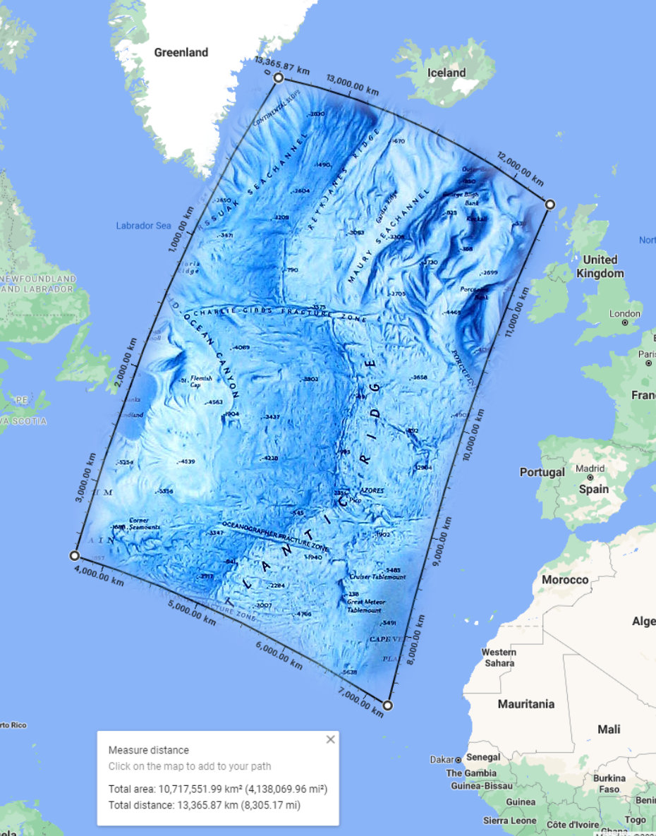
As important the ground terrain shapes are, as important are then that we have other than just flat ocean floor. Sure we never need to know what is below 500 meters depth, but 500-10 meters and it becomes important one. Like how to perform a attack on shore and push forward from there.
We have already aircraft like AV-8B N/A that is capable to drop sonar buoys.
Having submarines in the Mariana map going deep etc would generate many different missions for detection. But we don't need for that the ocean floor height map details.
But eventually it is easy to add when we have no in last few years started to have proper air-to-ground radar modes like soon coming M2000C terrain radar.
There must be someone would be very ready to do a "Hunt for the red October" version of the Soviet Burevestnik-class anti-submarine frigate event, but in all maps.
-
1
-
-
On 5/30/2020 at 12:36 PM, Northstar98 said:
Nobody is expecting it to be detailed, going any more detailed than the mesh of the pre 2.5 era Caucasus map would be overdoing it.
I would gladly take a ocean floor mesh resolution of 2 km for generic flat areas, and then 200-500 meters for the ridges and deep slopes.
This is of course case for ONLY if we would get at some point a sonar displays, as then we would have nice hunting to do. We anyways would hit to the thermal layers very often and see nothing more than flat
This, because I still sometimes launch the submarine simulator Dangerous Waters.
And if we talk about anyways this SONAR topic, it is required for the DCS because that exact system is then transferrable to the every SAM systems, AND not just SAM systems but for whole electronic warfare in the DCS including all Chaff, Flare, ECM, ECCM etc.
So we can go and take even the old 60's (and 70's and 80's) EW material and build like thousand times more complex and demanding EW for the DCS, including air-to-air, air-to-ground/surface and SONAR.
DCS stands for Digital Combat Simulator. Its primary subject is the Aviation. But it shouldn't be limited to that, as combat part is about everything. You have unit on ground, unit on surface, unit in under water and unit in air.
And considering that we would have few people sitting front of their computer in DCS, watching their display as SONAR or RADAR scope is a lot more interesting concept than having a few players as a soldiers on ground somewhere, shooting at something... Like, no! DCS doesn't work as infantry simulator. But it works great as vehicle to vehicle simulator.
This is what makes F-14 so amazing to fly when you have a friend who likes to be a RIO. Now take the view outside away and make that RIO sit in a radar wagon or radar compartment in a SAM, a boat or a submarine. If there is nothing happening in some area, those players can jump to elsewhere to do other tasks where are aircraft flying, submarine or ships moving.
If someone is so crazy about launching a AIM-54 Phoenix from 50 nm to the target, there are even more stuff about launching torpedo with various guidance methods, timers etc. A real cat and mouse game.
Where some players could be flying in their Hornets and Tomcats fighting a fleet defender or strike missions etc, some people are in ships operating surface-to-air radars, surface-to-surface radars and SONAR.
And that is where the ocean floor height map would really come to play when you have places closer to shore where you don't to get dive deeper than 200 meters,
On 5/30/2020 at 12:36 PM, Northstar98 said:Finding accurate data and translating that into a mesh isn't too difficult a task either AFAIK.
It isn't. That is public domain data.
-
1 minute ago, Xilon_x said:
how deep can a modern military submarine go?
Those are military secrets of highest classification level, so public doesn't know.
1 minute ago, Xilon_x said:it certainly does not reach 11000m of depth.
The only known information is "at least 400 meters" but how much deeper, that is classified.
11 000 meters would be silly to even think about. More like 500 meters is already serious crush depth.
Every 10 meters adds 1 bar more pressure, so 500 meters would be 50 bars pressure.
Considering that WW2 Uboats had crush depth below 250-300 meters that puts very severe limitation for over 500 meters even for modern.
-
1 hour ago, Hammer1-1 said:
If its advertised you can launch off of a designated radar point, then thats what it should be able to do. The only weapons available to do just this would be JDAMs, and if its not accurate then it defeats the purpose. Also, the nitehawk reference is kind of a bad analogy; you could theoretically spot the laser thus giving away the aircrafts location. Different points of logic.
Yes you could spot the laser source if you point laser at the detector. But again it is not enough. It is not a IR laser for NVG use like you can do for pointing. The Harrier Litening G4 supports dual-mode laser, where you fire laser designator and IR laser same time so you can guide laser weapon and see the laser with a NVG simultaneously.
You can detect the laser spot when it reflects energy to Laser Spot Warning sensor, that are in combat vehicles like MBT and modern IFV. So they know they are painted and would pop smoke and move in cover where they can't be painted. The smoke would as well scatter the laser energy, causing weapons to lose a lock and go dumb.
Examle AGM-65E and AGM-65E/2 (added capability for self-designation, since 2012 or so. While normal AGM-65E you can't self-designate) has safety feature that once the laser beam is lost, missile will perform hard vertical maneuver and disable it warhead (render it dud). This so that if you need to abort the weapon guidance, you can just shut off laser or quickly turn elsewhere and strike is cancelled.
So when a MBT pop smoke, laser is lost and your maverick goes crazy Ivan and is rendered useless.
If you launch AGM-65E for self-designation, the missile can cross the laser beam with it smoke and cause laser blocking and lose laser spot and go crazy....
-
4 hours ago, Spectre1-1 said:
see: nitehawks not being allowed to self lase despite being advertised with the capability
The Nitehawk pod is sad story for DCS. In 2005 it would be the main targeting pod for our USN C model hornet (Only Marines D hornets and Navy Super Hornets used ATFLIR and LITENING, the C hornets had only Nitehawk in use) as only 1-2 ATFLIR and LITENING were in testing purposes for future decision that what USN/USMC and Spain will purchase. Why it is more fictional that we have ATFLIR and LITENING when we should have only Nitehawk, as only after 2005 those were purchased and taken in service (suggestion for ED, keep ATFLIR and LITENING for Hornet, but develop Nitehawk and make it primary sensor pod).
The Nitehawk requires two pods if wanted to self-designate. You have laser designator and then another pod with LST/CAM to generate the target coordinates for your own system or just as wingman to carry that another pod. This is why ATFLIR or LITENING were so big deal as they left one attachment point free for weapons by having all in one pod.
And as you say, Nitehawk was not allowed to be used for self-designation because it was so low quality video and FLIR that pilot couldn't see is he targeting friendlies or enemies. So too many "blue on blue" accidents and hence LST pod was only allowed to be used for ground designated targets.
We are getting the new FLIR modeling, that hopefully adds proper low resolutions to all optical systems and renders them a lot worse than they are now.
So welcome the 320x240 (LANTIRN and Nitehawk) and 640x512 FLIR as ATFLIR and LITENING AT and finally DCS best targeting pod, AV-8B only Litening G4 with 1024 x 1024 FLIR and CCD (with laser scanning imaging process).
-
1 hour ago, deathbysybian said:
What's the purpose of marking targets in the a2g radar?
What's the point of Wags tutorial on how to use it to attack ground targets?
The A-G radar is not used in reality same way as in Wags video because it is so bad.
It is good when you need to find a large ship at sea, or you have very definitive ground echo like train station, harbor or big city.
Why the A-G radar is used in sea mode. But you don't find stealthy ships at long range or smaller boats even at close. Why navy has been not so effective against drug traffickers who are using high speed small boats. You need better, larger radars to that. Why helicopters can carry massive radars or you simply call E-2 Hawkeye for business.
You can find those first on map, then Designate on radar for general area. 50 m accuracy is pretty amazing for it. Remember that you are dropping a 250-500kg bombs that has effective radius of that level against lightly armored vehicles and non-armored vehicles all the way to 100-300 meters. It is limitation in DCS that fragmentation is not simulated, why you need to be almost pinpoint accurate with bombs.
The Litening or ATFLIR shouldn't be great for GPS coordinates generation, but you are very accurate with laser. This is reason why JDAM is used (as few pilots said) mainly via pre-designated coordinates on the ground. You just fly the JSOW or JDAM on optimal release position and get out.
Navy ECM operations are as well about quickly getting in and out, this you can hear from fighter pilot Podcast about wild weasels. So they just spend could minutes in the danger area and then bug out. You don't have time to search and designate targets there, why you want to have all ready when you enter the area and you just need to designate weapons in Waypoints and release.
Why you are flying with A-G radar, you need to understand what you can get with it. On a flat desert you can find a compound, but it is on map as well. You can designate about main directions in that compound, but not individual buildings as you don't have time.
In a reality your A-G radar doesn't pick up moving vehicles either than on highway or other paved road. Off-road, camouflaged, anti-IR and anti-radar methods renders vehicles invisible to radars and FLIR so effectively that you don't spot them as now in DCS. Why you need to be looking FLIR as black and white TV to what you are seeing and interpret it. So you wouldn't be looking "big white blobs" but old school TV.
And your radar would be just useless as it can't detect vehicles as they don't reflect any radar signal in sensible manner.
DCS doesn't simulate any of that, why you have so easy time to find moving vehicles and spot them with FLIR.
-
13 hours ago, 5k0rp1on said:
My guess is they will be contextual but thats just my guess. Like hat switch up to look for targets, then say hat left for tanks, trucks, infantry, etc
Something like that. You can just go quickly in other like "Up, Up, Right" to get wanted action. And you don't need to keep looking that what is on screen.
-
1
-
-
2 hours ago, Tippis said:
Yes, that's reasonably how it should work (well… sort of). But it doesn't.
Yes, that is how it should work, but doesn't. Why the big need to be fixed first or it is not usable for anything.
We need more choices to the settings and they need to be based on to mission file, not on designer personal settings (which is illogical).
It would anyways be better to switch to a drop-down list in each setting than keep two checkboxes that just confuse people.
Just label them as "Disabled", "Player/Client setting" and "Enforce".
-
1
-
-
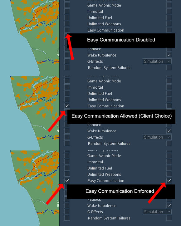
12 minutes ago, cfrag said:
Interesting. So it is indeed about control. I understand and agree that mission designers strive to set a tone, to put together an experience, much like a composer of a musical piece, a cinematic director, or the writer of a novel. And I know that there are artists (and yes, to me missions are pieces of art) that also strive to control how their oeuvre is consumed.
It should be like any other option in the mission:
If the server wants to support Easy Communication for those clients who need it, it is then opt-in for those clients for their own and everyone who has it disabled will not have it.
Then it can be disabled for everyone, or it can be enforced for everyone regardless their setting to have opt-out from it.
- Not for anyone
- Only for those who want it
- For everyone
And everyone would be happy, it is still a thing that cheaters couldn't use it if it is disabled and so on disallowed for everyone.
-
5
-
-
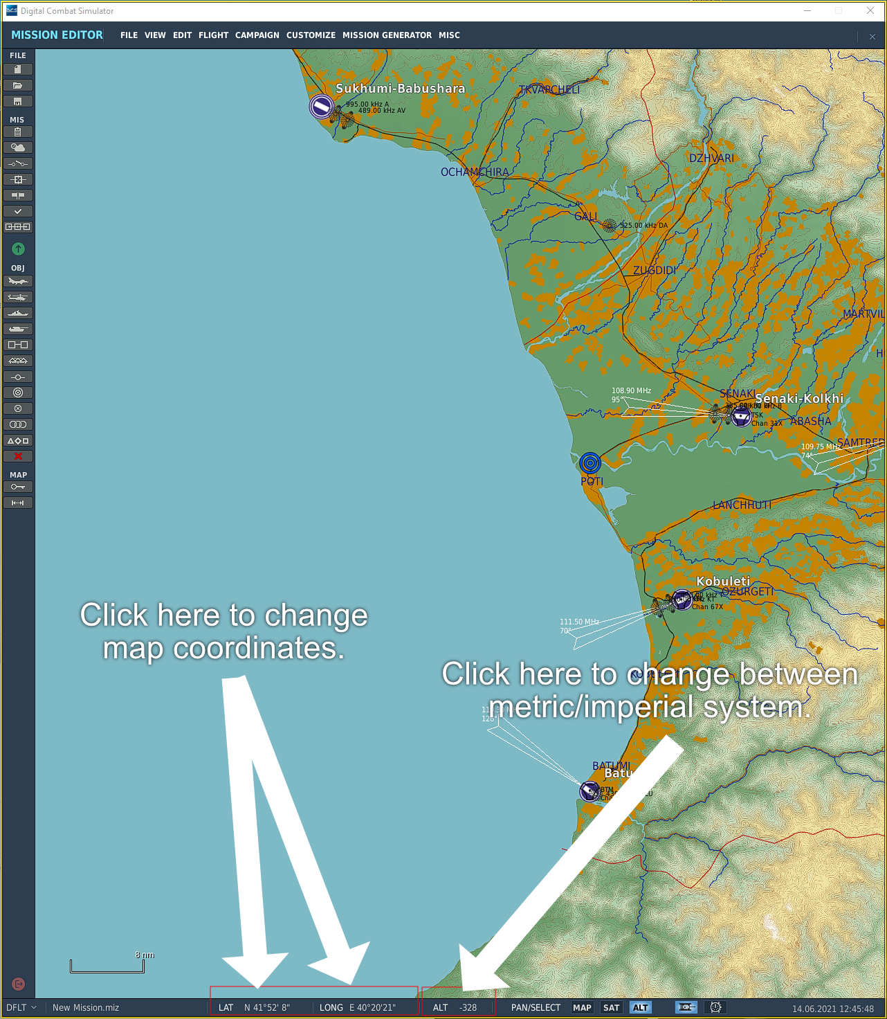
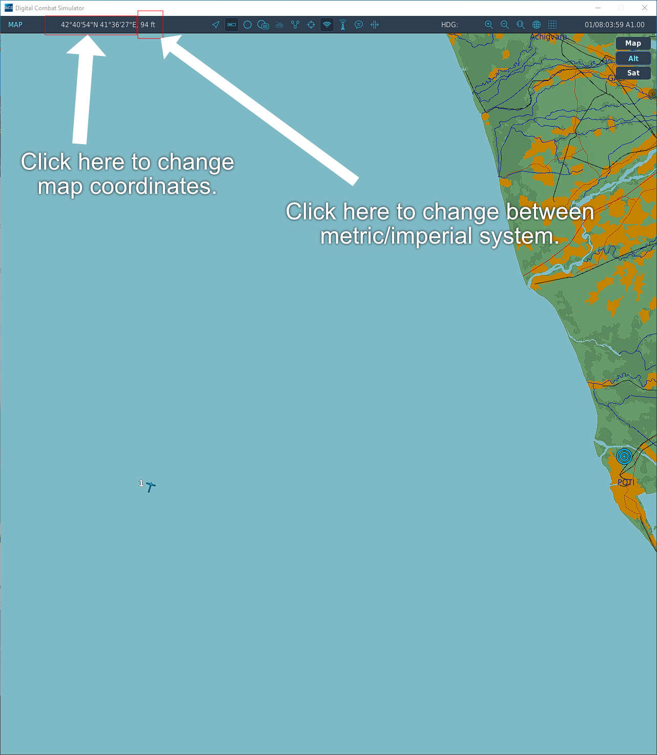
Here is how I would make it in the editor, we have at the bottom already two values.
1) Coordinates where the cursor is on map.
2) Altitude to terrain where cursor is on map.
Even when they are not visually buttons, they could be used as such to switch between them when clicked with mouse.
That would allow maintain the interface, but as well add the functionality.
And we can do that same thing for the external views in the game view, and the F10 map.
Adding a two buttons to make that switch in the toolbar wouldn't be bad. It would be visual and clear for everyone that "this does that" every different view then. As without the button UI element it can be easily mistaken as user can't know by looking that coordinates or altitude numbers are clickable.
This should be a couple hour work for a programmer as the functionality is already in it.
Then the settings function should be replaced by the feature to make it automatic based the flown aircrat.
So if the player has a metric aircraft, map is automatically set to metric mode as long that aircraft is flown.
If it is imperial aircraft, then it is swapped to that automatically.
-
3
-
-
Just now, MAXsenna said:
Not to be an Ass. But how do you change it "in" the editor and the map?
In editor you change it from View menu. You need to move mouse to refresh view then.
As I said, we have this feature in editor, but not the button for toolbar. And we don't have it as button (or feature at all) in F10 map.
Just now, MAXsenna said:I'm sure@sirrah misunderstood you because you probably meant that "one can change it *in* the settings *for* the editor and the map".
One can do it there as well, but you don't need to for editor.
That is the silly part, we have the quick change in "View -> Unit" drop-down menu in the editor, but we don't have it in the F10 map. The functionality is right there but not added.
1) Add the button to toolbar to switch between Imperial and Metric.
2) Remove the "View -> Unit" feature
3) Add that button in the F10 map view.
4) ???
5) Profit!
Just now, MAXsenna said:But I agree Fri, this feature request comes up from time to time, just let's cross our fingers. Have feeling this thread is done.
We have like 10 threads about this, why I don't hold my breath this is anytime soon implemented....

-
2
-
-
3 hours ago, cfrag said:
I took the liberty of completing your assertion with a relevant tidbit to make the part that some people have problems with more visible.
IMHO it is not about servers as dedicated ones, it is as well about a single player missions where mission designer decides how the mission is to be played (SP, CO-OP or MP).
3 hours ago, cfrag said:I'm not convinced that things always do get more interesting (as your phrasing seems to make out, but I belive you probably meant 'Things can get..'), but I think that's not what this discussion is about. To me, it's about forcing one's choice on others; the implied assumption that if I didn't enforce, other people would take advantage of a feature that *I*, the server's owner, disagree with. There's not too much wrong with control-obsessed owners, and since we are talking about an option, I don't mind.
It is same as with any weapon, unit etc. The mission designer decides that what weapons are available and how many. What units are available and how many. Is there unlimited fuel, ammunition, is there a NAV system available, are there external views, can you see everyone on the map etc.
If someone wants to deny a unlimited weapons for air-quake server, then it is their option. If someone denies a NS430 navigation system, it is their option.
Just having a opt-in to enable the unrealistic automatic map marker fixes everything (not opt-out). Those who want it for the training purposes can enable the feature.
3 hours ago, cfrag said:To me it's the mindset of people who want to dictate terms to others that I find questionable.
Do you recall anyone supportive for disabling it saying that it should be forced to everyone by removing the feature from the game?
-
4 hours ago, sirrah said:
Alt-Y only changes the coordinate values, it does not change the ruler to km's. Something that is useful for instance for the Hip (and soon the Hind) with their doppler systems
Did you miss this?
"Need to remind that we already have the option to switch between map coordinates values in editor and in F10 map."
"But this is like 10th wish thread about this very exact topic at least since 2016."
-
9 hours ago, frostycab said:
Making some sort of attempt to address the actual topic of this thread, I don't see why it couldn't or shouldn't be a thing. The Russian birds and the German warbirds have instruments marked in metric, so it could be beneficial to them. After all, I'm sure that the charts that real-world pilots of those planes use(d) would have been marked with the relevant scales, so being able to reflect that in the F10 map would be nice.
Need to remind that we already have the option to switch between map coordinates values in editor and in F10 map.
But it is not a simple button click in the GUI but F10 a shortcut LAlt+Y.
We should have these as buttons on main menu bar in map at top and bottom in editor.
But this is like 10th wish thread about this very exact topic at least since 2016. So I don't hold breath that we get it anytime soon.
-
1
-
-
55 minutes ago, myHelljumper said:
No, I did not explain correctly.
Error is on my behalf....
55 minutes ago, myHelljumper said:The contacts are shown for the the absolute duration of one search pattern, I think a search pattern in 4bar/60° lasts 4.8 seconds, this means that the contact will be displayed for precisely 4.8 seconds.
Okay.
-
21 hours ago, AvroLanc said:
Anything like Jesters command wheel and some of his switch settings options might be an expectation too far. The available publicity on his exact functions are worryingly absent.
AFAIK You don't get the same pie-menu but a 4-way hat designed menu. So you use a one hat in joystick to command the Petrovitch.
-
1
-

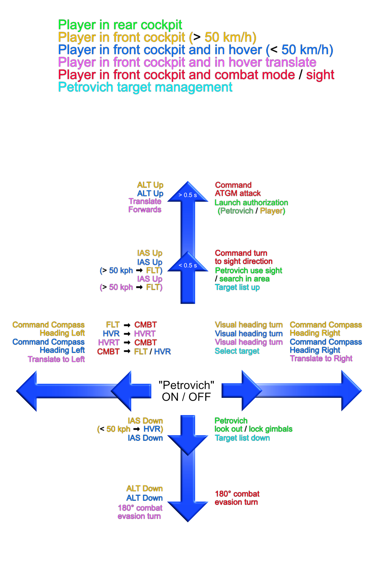

Petrovich 5-way hat commands
in DCS: Mi-24P Hind
Posted · Edited by Fri13
Something like this?
We don't have any combat (CMBT) functions for Short Right/Up/Down yet. And Long Right/Left are as well missing. Likely we have there something like "Maneuver to right" or "Hover stop" or something that is not in the FLY mode.
Edit: ED, please fix the comment box so it doesn't randomly delete all the text and leave some attachments randomly while deleting rest....