
VTJS17_Fire
-
Posts
2994 -
Joined
-
Last visited
-
Days Won
1
Content Type
Profiles
Forums
Events
Posts posted by VTJS17_Fire
-
-
There are some videos on YouTube.
-
When I read this thread I always have to think, that some of you guys maybe should try Operation BlueFlag, a dynamic multiplayer campaign.
I read about the last round of Operation Blue Flag and found this concept very interessting. But I read also about the scenario of the next round, which is limited to Fox2/ Guns and no AWACS/GCI, IIRC. :(
-
The AIM-120 A was delivered for the first time to US forces in 1991. Therefore it wouldn't reach a country considered to be a threat to the French before at least a few year.
But the AIM-54 was delivered to the U.S. Navy around about two decades before. And that is/ was a Fox 3 missile, as well.
-
You don't fly into combat that way because the chance of being shot down is inordinately higher.
Not only that. You have another adversary: The ground. You have to fight against the enemy and with concentration of all the systems and your tactic, you also have to fight against the mountains. That's a factor, you don't have at mid to high altitudes.
On the other hand, I'm not going to conclude that the tactics we see in DCS are wrong.
You can't say, they're wrong. You can say, they're not real or work only against new virtiual pilots, in these simple airquake scenarios, where you often meet one vs. one or similar situations.
As long as you reach your object - shoot down the enemy aircraft - it's the right tactic. I also tried some real life tactics from the 70s, such as that one from Operation Bolo. It has some disadvanteges, but it worked.
But most of the used tactics I've seen in public, don't work against organizied groups (with TS3) in a more real scenario, with AWACS and SAM so to say.
And these hide&seek tactics don't work in every terrain. In the Caucasus you have high mountains and tight valleys, great to hide and pop-up. But in Nevada or the Strait of Hormuz map, you don't have such an environment. So with the new maps - more sea and flat terrain - all these pilots have to adapt new tactics to get to WVR range.
-
Flying low was also popular with the Iraqis during Desert Storm IIRC. They used terrain masking to prevent detection to a certain degree.
Maybe some, but not at all. Their MiG-25 interceptors did often a straight climb to high altitudes to intercept strike packages.
My 2 cents.The "air-quake" scenarios that we see so often in DCS are totally unrealistic, at least for 4th gen aircraft. This is due to:
1. Mission designers not putting in awacs
2. The missiles are badly modelled in DCS
3. The radar and ECM in DCS is a 20+ years old code (the same as Flanker 1) that was never too realistic to start with.
I agree with you in general, but the radar is less a problem, IMO.
To leave out the AWACS support in combination with restricted export rules (for LotATC for instance) is a big issue and a no go for me.
But more important to me is mission design. Where in reality do you have two coalitions which fight against at a invisible line over and over again? You always have an attacking/ offensive force/ coalition and one defensive. Sometimes more on one or both sites, but as good as never "neutral" to their intentions (attacking/ defending). Except WWI.
-
In real life, you would counter a F-15 flight only with GCI/ AWACS support in the M-2000C. Since the other side have also GCI/ AWACS available, it doesn't matter.
I also hate hide&seek tactics for my own playstyle, but the North Vietnamese did the same in the 60s/70s with their MiG-17/21 jets against the Phantoms.
If I'm inferior in technology and/ or firepower, I would (and do) counter it with manpower, say more aircraft (this is also, what the North Vietnamese did). With that, you can use more advanced tactics than alone or in a two ship.
In reality, you try to counter a force always with advanced technology (US, F-22) or with a higher number (Chinese philosophy).
-
Ja, zur Blue Flag habe ich mich auch schon belesen. Wobei die nächste Runde mit den neuen Rahmenbedingungen bzw. dem neuen Szenario auch kritisch diskutiert wird.
Das wäre aber schon eher etwas für mich.
-
Hi 51st,
find's gut, dass es solche Events in der Community gibt und verfolge den englischen Thread dazu.
Leider ist mir das Setup zu arcarde, da fehlt einfach der Realismus an allen Ecken.
Ich wünsche euch dennoch viel Erfolg und Spaß mit dem Event.
-
Dann könnte man sicn die ganze Simpitbauerei nämlich schenken. Ich glaube mehr Immersion geht nicht.
Das glaube ich nicht. Piloten (über)leben seit den 70er Jahren, weil im Cockpit und am HOTAS viele Knöpfe einzigartig geformt sind und "automatisiert" betätigt werden können, ohne hinzuschauen. Das Prinzip kann man am TM Warthog gut erkennen. Dort hat jeder Schalter eine einzigartige Form und kann anhand seiner Lage und Beschaffenheit ohne Blickkontakt gefunden werden.
Alleine mit einer VR Brille wird das nicht funktionieren, weil die Haptik fehlt. Die Immersion ist zwar sehr geil, aber der Mix machts. Habe am WE auf der IFA mal die Samsung VR Gear getestet, kein Meisterstück wie Oculus oder Vive, aber für den ersten Test nicht schlecht. Meine dreijährige Tochter fands auch sehr cool, "auf einmal draußen" zu sein, musste sie auf dem Arm aber festhalten, sie wollte immer weiter nach unten schauen. :D
-
When you fly a DCS aircraft, you can change the radio channel.
-
You can make new memories in the updated Black Sea map, NTTR, SoH, Normandy... and future maps...
Be sure, I will. :)
But to expand the caucasus map would be great, as well. As I wrote, maybe later or as payware DLC with a little bit of the north of Turkey. I loved the terrain there.
-
Awesome news on the NTTR expansion! Could have sworn that Wags said some time ago that they would include Fort Irwin National Training Center, but no mention here today. Has that been scrapped?
I also wondered. The map should be expanded around 150NM to the west and south. I'm looking forward to the new airports mentioned in the newsletter, but wondered what's with a few airfields in the south-western area. :huh:
-
So the bullseye reference in the bottom of the radar display is distance and bearing TO the bullseye? And that's relative to the TDC cursor location also, correct? Is there a quick reference to the aircraft's bullseye location?
1. Yes.
2. If your radar is on, yes-
3. Yep. Turn the radar to stby mode and you get your bullseye data.
-
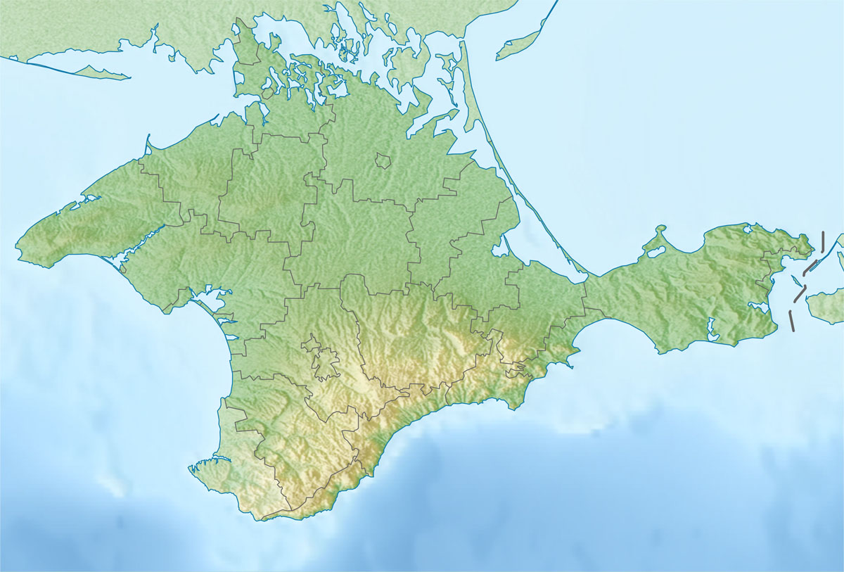
I always wondered why so many people would like to have crimea. It seems to me like a pretty flat and boring place to fly to be honest.
1st: Good old memories. :D
2nd: It isn't entirely flat. The south-east side of the peninsula and coastline have a nice low mountain range. We had a lot of fun with the A-10A there, in the region around Feodossija, as well. There were a lot of nice airbases, too.
3rd. Adds a lot of airspace, combat area and interesting missions to the map.

PS: And we had our homebase at Saki AFB. Would be nice, to take-off from there, again. :)
-
 1
1
-
-
Hi ED,
since your last patch the ATC doesn't give me any wind data, neither when taxing/ take-off nor requesting permission to land. I'm using dynamic weather.
This bug occurs at least in the F-5, M-2000C and F-15. I think it's buggy in the other aircraft as well.
Sample mission attached.
-
Wednesdays training:
-
Not implemented in DCS.
IIRC Zeus said, that it will be implemented later, the INS has to be finished first. But it is already clickable.
-
Ich bin noch nicht in Nevada geflogen (warte auf den Merge), aber mein letzter Stand war, dass nur einzelne Bäume (keine Wälder) über ein Kollisionsmodell verfügen und auch da nur der Stamm. Simmt das noch? Für Sichtdeckung würde das jedenfalls nicht ausreichen.
Na ja, ganze Wälder gibt es dort einfach nicht. Ist halt Wüste.
Aber als ich anfangs mal mit Huey und Mirage in die Bäume geflogen bin, hatte ich nur die Baumkrone gestreift und das hat genügt.
Evtl. können die deutschen Tester mehr dazu sagen, wo genau die Hitboxen der Bäume liegen.
-
Mit den ganzen schönen Helis brauchen wir aber zwei Dinge ganz dringend... Bäume mit Kollisionsmodell und Bäume die mal auch vor der AI als Deckung nutzen kann, ohne dass die durch Bäume durch sehen kann. Vor allem auch auf der Kaukasus Map
Erstes existiert bereits in Nevada (2.0) und ich denke/ hoffe, dass dieses Feature auch beim Release von DCS 2.5 auf der neuen Kaukasus Karte vorhanden sein wird.
Ob letzteres auch der Fall ist, habe ich noch nicht getestet. Und in Nevada stehen dafür die Bäume wohl auch zu weit auseinander. :D
-
Und wie siehts mit
Eurocopter tiger
Blaxkhawk
Osprey
Etc
Aus
Zum Tiger hab ich mal was gelesen. Aber so lange keine ingame Screenshots auftauchen, geb ich da wenig drauf. Der Rest befindet sich aktuell nicht in Arbeit.
Könnten sie auch einen A400M Modelieren?Modelieren, ja. Zum Leben erwecken eher nicht. Sieht ja schon in der Realität schlecht aus. :D
-
One of our squadron mates (Tomcatz, the modder) in a glider. He was in the front seat, an IP was flying in the backseat.
-
1
-
-
Training 08-26-16
-
1
-
-
Great find! :thumbup:
-
I would like to see the crimea again, as well. And the north of Turkey, too. I read Wags copmment on this. Maybe, both as a payware DLC in the future.


If we can call this BVR or any Long range operation in the M-2000c
in M-2000
Posted
I can ask a buddy of my squadron, who flew sometimes on this Server. Maybe he has an acmi for you.