
buur
-
Posts
580 -
Joined
-
Last visited
Content Type
Profiles
Forums
Events
Posts posted by buur
-
-
@Comrade Doge an other question: Is it possible to get the coordinates from the IP (initial points) which we can add in the mission editor?
It would be very handy if we are possible to add them to our flight plan. -
@Comrade Dogethanks for the great program it is very helpful.
Have you ever think about a TheWayBoard? A kind of kneebord with all the Waypoints added by your program?
Also I like that we can import waypoints from other player or other sources. Very helpful. A couple of weeks ago I made an extensions with the fixes in the Marianas area. You can found it here:And here I have also attached a "tw" file with this fixes so you have easy access to this point and you can easily integrate them into your flight plan.
-
 1
1
-
-
vor einer Stunde schrieb QuiGon:
Quick question: Is ADF navigation implemented in this module?
No, only TACAN
-
 1
1
-
-
-
I don't think that chatgpt can help you with the question. The answer of chat gpt is only helpfull if you place the buildings in the mission editor.
-
There are two types of buildings in DCS.
1. Buildings already on the map. I never heard or see that they are respawnable.
2. Buildings placed via Mission editor.Which buildings do you mean?
-
Hier mal die Discord Einladung, da bekommt man viel Hilfe: https://discord.gg/gj68fm969S
Hier der Link zur Dokumentation, ich empfehle mit der develope Version zu arbeiten, da sind die coolen Sachen drin: https://flightcontrol-master.github.io/MOOSE_DOCS_DEVELOP/Documentation/ -
Hui, wie das im Mission Editor genau geht weiß ich jetzt auch nicht. Ehrlich gesagt mach ich alles das etwas "komplexer" ist nicht mehr im Mission Editor sondern mit Moose. Das finde ich einfach angenehmer.
-
vor 8 Stunden schrieb Rango:
Ja, ich habe zwei Waypoints. Leider macht es auch keinen Unterschied, ob ich die Follow-Task nur beim ersten oder bei beiden Waypoints einstelle. Der Heli fällt immer im Laufe der Mission langsam aber stetig in Richtung des Carrier-Hecks zurück. So nach 15 Minuten Laufzeit ist er dann bereits auf Höhe der Heckkante angekommen. Habe mal die Mission-Datei angehängt. Seht Ihr einen Fehler?
Test -based on SC Population Template - Basic Setup - FA-18 -V2.miz 22.89 kB · 4 Downloads
Hab mir deine Mission auch mal angeschaut und konnte den Fehler nachvollziehen.
Mal einen genaueren Blick reingeworfen und gesehen das du unter den Conditions is user flag angeklickt hast.
Hab ich rausgenommen und schon läuft es wie gewünscht.
Warum da ein Fehler passiert...? DCS halt -
Hast du einen Last Waypoint eingestellt?
-
vor 18 Minuten schrieb Charmin2105:
Mal ein Frage, wo ich nicht so genau weiß ob das überhaupt so möglich ist.
Ich habe 4 Ziele die als WP 3-6 "markiert" sind. Gibt es eine möglichkeit die als Targetpoints zu "konvertieren", ohne die F10 Map zu nutzen?Wegpunkt auswählen, Designate und dann TOO drücken. Dort dann den gewünschten Targetpoint auswählen. So aus dem Kopf sollte es das gewesen sein.
-
Ist das nicht einfach Werbesprech für das was du schon geschrieben hast? Die herausnehmbare Sperre? Kommt halt immer darauf an wie man es verpackt

-
vor 8 Minuten schrieb smik:
Hi
I wanted to fly with the A4 after a long time
When I use the key, the communication menu does not appear.
Some idea?
It has worked without problems in the pastWorks for me very well, so here the usual problem: Is your canopy open?
-
vor 17 Minuten schrieb Maltschik:
Ich hab Basiskenntnisse im ME und steh grad aufm Schlauch… also:
Fahrzeugkolonne mit Wegstrecke von A nach B soll erst losfahren, wenn Spielerflugzeug in Zone ankommt / oder alternativ mit „später Aktivierung“ losfahren bei Spielerankunft.
Geht das mit zwei, drei Triggern, oder was muss man alles machen? Gerne auch nur Stichpunkte als Hilfestellung. Danke im Voraus!
Eigentlich hast du in deiner Beschreibung schon alles genannt.
1. Fahrzeugkolonne setzen, einen Weg vorgeben und dann den Haken bei späte Aktivierung setzen.
2. Triggerzone setzen und dann den Trigger Einheit ist in Zone mit dem Kommando Gruppe Aktivieren. Und das soll dann dein Konvoi sein.
-
1
-
-
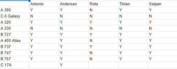
Ich hab mir vor ein paar Wochen mal diese Liste erstellt welches Flugzeug aus dem CAM Mod wo startet/landet.

-
1
-
-
Überprüf mal ob die Flieger überhaupt von den Flughäfen starten können. Eine C-5 Galaxy beispielsweise ist so groß das sie von keinem Flugplatz der Marianen starten/landen kann bzw. keinen Parkplatz findet.
-
Hier sind die anderen die bei mir laufen: SetDestination({"Antonio B. Won Pat Intl","Saipan Intl","Tinian Intl"})
Den für Andersen hab ich ja oben schon geposted.
-
Du must die Airportnamen in eine Tabelle schreiben. Also mit geschweiften Klammern drumherum. :SetDeparture({"Andersen AFB"})
Wenn Moose geladen wird schreibt es alle Airbaisen in die Logdatei. Da kannst du dann auch die richtigen Namen raussuchen.
-
It seems that your recovery script is based on Moose. Best is you post this question in the Moose discussion or on the Moose discord.
-
DCS and his circles:
If you have a AFAC, he makes a turn with 4.35nm radius and a height off 4000 meters around the target.
If you have a round orbit, the AI made a 2 minutes turn. The only one which is correct.
If you have a raceway the orbit follows following formula: turn_radius = 0.0211 * speed -3.01, where speed is the ground speed. The bank angle is fully incorrect.
If you are refueling in a racetrack, the tanker will turn with a 10nm radius.
Nothing fits together.
I agree to the thread opener that a little bit fine adjustment of the orbiting behavior of the AI will be highly appreciated.
-
An offset make sense if you use the waypoints not "as point on your way" but as reference points. It comes from the early days of navigation without GPS.
For example: You have a mountain as waypoint/reference point and your flight plan is to fly toward the mountain and make a turn 5 miles before reaching the mountain. In visual flying this is easy to do and the offset give you the same opportunity for your navigation system.
Why should you work with waypoints as reference points? It gives you a better situational awareness if you place the points over important places of the map. Also it is easier if you fly together with other flights which have a different route than you. If you have a waypoint called BIGHILL and you send a message over radio that enemies are north of it, all flights know easily where it is.
-
And here is the next step. I've included the airways.FalklandAirways.lua
As before, Moose is required.
-
2
-
-
First of all, the best way to discuss Moose problems is the Moose Discord https://discord.gg/gj68fm969S
Please post the additional lines of the error message. Normally there is a indication in which line of your script the error occurs. From the first look your script looks ok and I can't see any error.
-
Hi,
I made a small script which adds the waypoints/fixes to the F10 map. I got the fixes from the skyvector map.
The script requires Moose.FalklandFixes.miz
-
2
-
[Known Issue] ATHS Not working in Single Player anymore
in Problems and Bugs
Posted
No news yet. Adding targets via script still not possible.