Skrzatek
-
Posts
12 -
Joined
-
Last visited
-
Sorry for late respond, I've been struggling with my overall pc performance. Yes, it is working as it should. But I've been able to notice INS drift after 20 seconds. (I believe it was INS drift, I mean I noticed that shkval was drifting from the target each time I hit "uncage" button.) By the way: is shkval screen limited to display certain amount of fps now? I think it has less amount of fps than the outside world view, but it may be only me and my poor pc.
-
HUD altimeter* relies on the radio beam that is pointed down, so at high bank angles it would not process the data or even not receive it. Same way as the HUD speed indicator that relies on doppler system that is also pointed down. * it is important that altitude must have a russian letter "р" that indicates feed from radioaltimeter. If there is no letter, it shows the barometric altitude, so there are no limits to the bank angle.
- 1 reply
-
- 1
-

-
Hi, I have a problem. After the update I cannot slew shkval to selected target either created in the PVI-800 or in the datalink panel. It moves to the correct bearing, but does not move in the vertical axis like it was in the BS2. All targets are in correct position according to ABRIS chart.
-
Hi, you probably figured it out, but I will explain it anyway (in case of someone with the same problem as you will be reading this thread in the future). I must admit, that I have nautical education, so forgive me if I won't use "proper aviation terms". So first of all basic terms: - Heading is an angle between the North and the direction your nose is pointing. (Remember that there are few different Norths related to your heading). - Track is your "course over-ground". You must remember that your aircraft is constantly flying in the fluid. It means that you can point your nose at one direction, but the wind will push you to the side. So the Track is just an angle between the North and the direction you are moving. In ABRIS "BRG" is the Bearing towards the next steerpoint. You must be aware if the next steerpoint is a waypoint from your flightplan or a target you've just entered or something else that has been selected by you on the chart. DTA is Desired Track Angle. It is an angle from one steerpoint towards the another (one you've just passed and second you want to reach). So it is a Track you want to reach in order to move straight towards the next steerpoint. Under your chart there is a scale that shows you your XTE (Cross Track Error) - the deviation from your Track measured in kilometers (ofc if you use metric system in your Ka-50). And the MOST IMPORTANT THING - ABRIS is not fully connected with the PVI-800. If you create a flightplan in the ABRIS, you still have to create waypoints in the PVI-800 in order to fly by autopilot. If you create waypoints in the PVI-800, they will not appear on the ABRIS, so you must create a flightplan if you want to see them on the chart. But funny thing - if you create a navtarget in the PVI-800, it will be displayed on the ABRIS. "The airports are not counted for the PVI-800 right ?" I don't know what you meant by that. You can enter positions of two airports in the PVI-800.
- 1 reply
-
- 1
-
-
How will you model the SPO-15 Beryoza? I read that its documentation is still classified (but not sure if it's true).
-
Unfortunately I cannot provide a track. Plane was on a free trial and didn't think about saving one. All my actions are described and it was happening when I frequently used flaps during multiple touch and go landings (in most cases 2 attempts were enough to brake them). I can also provide information that it happened both after autostart and manual one, so all switches (according to checklist) were in the correct positions. Maybe the pump shouldn't be used so often with such short intervals?
-
Yes, I always return the lever to neutral, but only in the air. On final I didn't return the lever to neutral after extending flaps to 55 degrees (I extended them fully down after passing the marker). Then I retracted them on the ground and after few seconds I switched the lever to 20 degrees position for takeoff.
-
I was flying a MiG-15 and had a problem with the flaps when I used them often. After two touch and go landings, they stopped extending. I'm sure I caused this problem by breaking the hydraulic system somehow. But the general question is what did I do wrong? After takeoff I retracted the flaps from 20 degrees position when IAS was no more than 350. Then, on the approach, I extended the flaps to 20 degrees when the IAS was around 350 and held the lever in that position. After passing the marker I extended the flaps to 55 degrees and held the lever in that position. Then after slowing down I retracted flaps and extended to 20 degrees.
-
 Skrzatek changed their profile photo
 -
fixed MiG-15bis : Unable to Open Close Canopy, Jettison Canopy or Eject.
Skrzatek replied to ElvisDaKang's topic in DCS: MiG-15bis
Did I miss something? Because it looks like this problem has NOT been solved. -
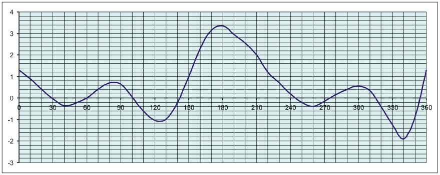
If anybody from the future is interested: The answer is yes, DCS does simulate deviation and many other compass stuff. The deviation table/graph should be in the manual. I attached a deviation graph from KA-50 manual as an example.

-
No, you confuse variation (or declination) with deviation. "Variation is the angular measure between the magnetic meridian and the true meridian at a given location." "Deviation is the deflection of the compass from the magnetic meridian." Due to influence of the vehicle itself on the compass.
-
Does DCS simulate magnetic deviation? I couldn't find this information anywhere and I'm very curious because it is a big problem when determining the course using a magnetic compass.