Thamiel
-
Posts
124 -
Joined
-
Last visited
1 Follower

-
Single Players: What would win you over to a multiplayer server?
Thamiel replied to Dangerzone's topic in DCS 2.9
As a DCS/MP/community pilot after approx. 2 weeks of trying out DCS/SP, I would agree with Mistermann that SP simply cannot keep up. For me, it started as a midlife crisis occupation and was never meant to last long. I never had a deep dive into the MP/public domain as the behavior of most players was not to my liking. But the companionship I found within that group (which at that time was simply choosen by size, activity and most certainly that friendly FNG approach of "lets do some flying together") now lasts for 5 years and still doesnt cease to amaze. It drove me to invest a lot of time into this hobby and it paid off by lots of MP missions just flying parade with friends into the sunset/rise after "surviving" two hours of intense action. I started mission design and struggled with the ME, I looked into RL air force procedures and thought about how to adapt them for DCS by normal / non-military guys (like me), I started writing MOODLE tutorials for CAS and RESCORT and even developed an aerobatics course for the warthog as a sideproject just for the fun of it. At the top of it, last year I enrolled in a local glider club to go for the real thing. All that came back with interest, as they say. So yeah, as in any normal social group of comparable size, there are guys who dont like each other. There are the service members which feel entitled to throw their RL knowledge around until they experience first hand that this is still a game, we are volunteers and earn our money somewhere else. You have the know-it-all, the socially challenged, the outright assholes (normally not for a long time to be remembered) as in any online group of people who would not recognize each other in RL. Until they do some offline weekends and after that all is well, or at least tolerable. You dont have to like them to fly Wing for them now and then. There are the casual pilots, the milsim types, there are the weekend flyers, the guys specializing in the color of every bolt of their singular beloved module, the Jokers capable of flying everything in their huge virtual hangar (and getting worried about their keybindings and HOTAS everytime they have to switch modules). The sleepy types surprising you with skills you hadn'nt seen before, the military veterans sharing stories about their employments and so on. It takes all kinds. If you cant stand company, that experience may be difficult to achieve. But being an introverted character myself, I found out a lot about myself during the last 5 years I would miss otherwise. -
Same here. Out of curiosity: is your full fidelity F-5 the legacy or the remastered version? [Edit: looks like it came with the last srs patch. It worked just fine until then.]
-
Of course it isnt. Also, its funny to think that the western powers wouldn't consult their own departments of science to improve their hardware and machine-human-interfaces. Of course they did. Everyone did. Its the military for gods sake. The British call it "attention to detail" and it starts with boot camp. Apparently they did come to different conclusion as one would suspect when pursuing different goals and intentions. I dont pretend to know how the russian pilot is trained to fit into that cockpit to work efficiently. Maybe he is only a small dependant cogwheel who relies on lots of GCI/controller types around him telling him what to do, how to fly and when to shoot in which direction so SA may not be that important to him. [Edit: if so, have fun flying that thing in DCS/SP] Of course it is an improvement over all MiG aircraft before it. Otherwise it would not have been commissioned. The question was, where to put this module according to the gradient of its learning curve. I dont think, there is a good DCS counterpart to compare it to. As I said, the closest module in weapon capabilities would be the M2k including a strong interceptor profile. But there the comparison ends between those two.
-
I dont talk bare numbers of instruments, I talk ergonomics. Even the F-15A is far better than the Fulcrum in that department.
-
Well there is no MFD in the first place, so yeah no pages either. But instead, we have multiple speed indicators and displays of any kind and so on, a "Uhrenladen" as we say, which normally is anything but clear and understandable.
-
Well. I dont make a statement about how much more difficult it is, I just try to explain why someone would regard the transfer from a western cockpit to an eastern one a difficulty to begin with. I cant really compare to the F/A-18 because I dont own this "one4all" module but yeah, it seems difficult to imagine that the Mig-29 could reach the level of sophistication of multirole aircrafts and all their payload delivery procedures. But then again, its a russian cockpit. You'll find a switch for everything and not necessarily where you are looking for it. If you are familiar with russian high fidelity modules (there are not that many) you will no doubt recognize many things in the cockpit of the Fulcrum that lets say the Blackshark features as well. You may even feel right at home. You may definitely not suffer from minimal pair problems like the guys who try to master the F-16C and the A-10CII at the same time getting nuts about what a DMS button push left long/short actually executes in those modules - depending on the current SOI. I simply believe that for what the Fulcrum is capable of on the outside, she brings a lot of switches and conditions and procedures to adhere to. If you are a Warthog pilot content to operate 8 switches or so in a specific manner to drop one dumb bomb CCRP on a tank, thats fine. If memory serves, the M2k takes only 4 to do that of which the first one is Master Arm ON and the last one is Consent to release? There was a reason why the M2k was a popular jet.
-
Being of the russian/soviet variety, one has some inherent difficulties to overcome when compared to western models most of us are used to. Basic things such as units, the availability and layout of cockpit controls and in more general terms, the installed equipment supporting solely the soviet doctrine of aerial warfare are quite different. So a fair comparison is not an easy thing to do. My suspicion being that it is meant to replace the M2k eventually and compared to the Mirage I find the Mig way more challenging to learn. But then again, the Mirage was build around the idea of an easy and flat UI with only a few knobs and controls to operate in order to make things happen the right way. Thats not my impression of the Mig. Russian/soviet design choices do not seem particularly user friendly across the DCS board. Speaking of leverages to work 20+ switches on startup or such things. So yeah, you may be in for a treat.
-
Its simply an ED version of / replacement for the phased out M2k-C. Because of that maybe thrown out too early for EA. Just look at the loadout. It is not meant to take on DCS's F14/16/18.
-
Flood lights?
-
Searched the forum for this one but came up empty. Also not sure if this is a bug or even if this is the right place to post it, the implementation of weapons being an ED responsibility afaik. It occured to me, that the Stingers on the Kiowa are capable of locking on ground targets (by tone and boxing them in the PDU) but do not guide after launch but overshoot them (mostly big time). But then again it could be pilot error by launching them too close. As this is obviously not the intended use of this WS, I wondered if somebody here knows more about this behavior.
-
Just to make sure: downloaded size != update size
-
I keep hearing that mantra over and over again, it almost sounds like an urban legend.
-
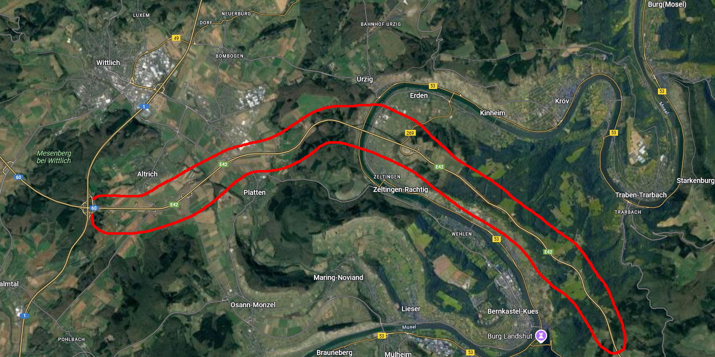
The crucial thing is that they were all different. There was no single standardized water tower as the map suggests. Especially not in East and West.
-
... as it was build, finished and opened for traffic in 2019. The whole highway E42 as depicted in the map did not exist during the 80s. Maybe that saves some space available for other things.

-
- 1
-