forewarnedisforearmed
-
Posts
5 -
Joined
-
Last visited
-
The detailing of Kenley's Dispersals and officers mess are awesome, as well as the control towers of other airfields; Makes me really hope for RAF Hornchurch to be added to this map, if you are making Hornchurch then awesome, if not, please please do. If you do come around to making it, I have plenty of reference, research and data for the airfield site, such as photographs, site plans and aerial photography that I'd be more than happy to provide. Hornchurch was still in use by certain squadrons during 1944, and with the development of the winter version of this map, it was almost certainly in active use in Winter 1944. Hornchurch would also be in the High-Detail area as seen in the pinned post in the Normandy 2.0 forum. Other than that, terrific stuff Ugra, this map is really looking awesome
-
Normandy 2.0 update - New airfields
forewarnedisforearmed replied to MAESTR0's topic in DCS: Normandy 2.0
All well and good, but I am still yet to see Hornchurch on this map Is it in the works, hope it is. -
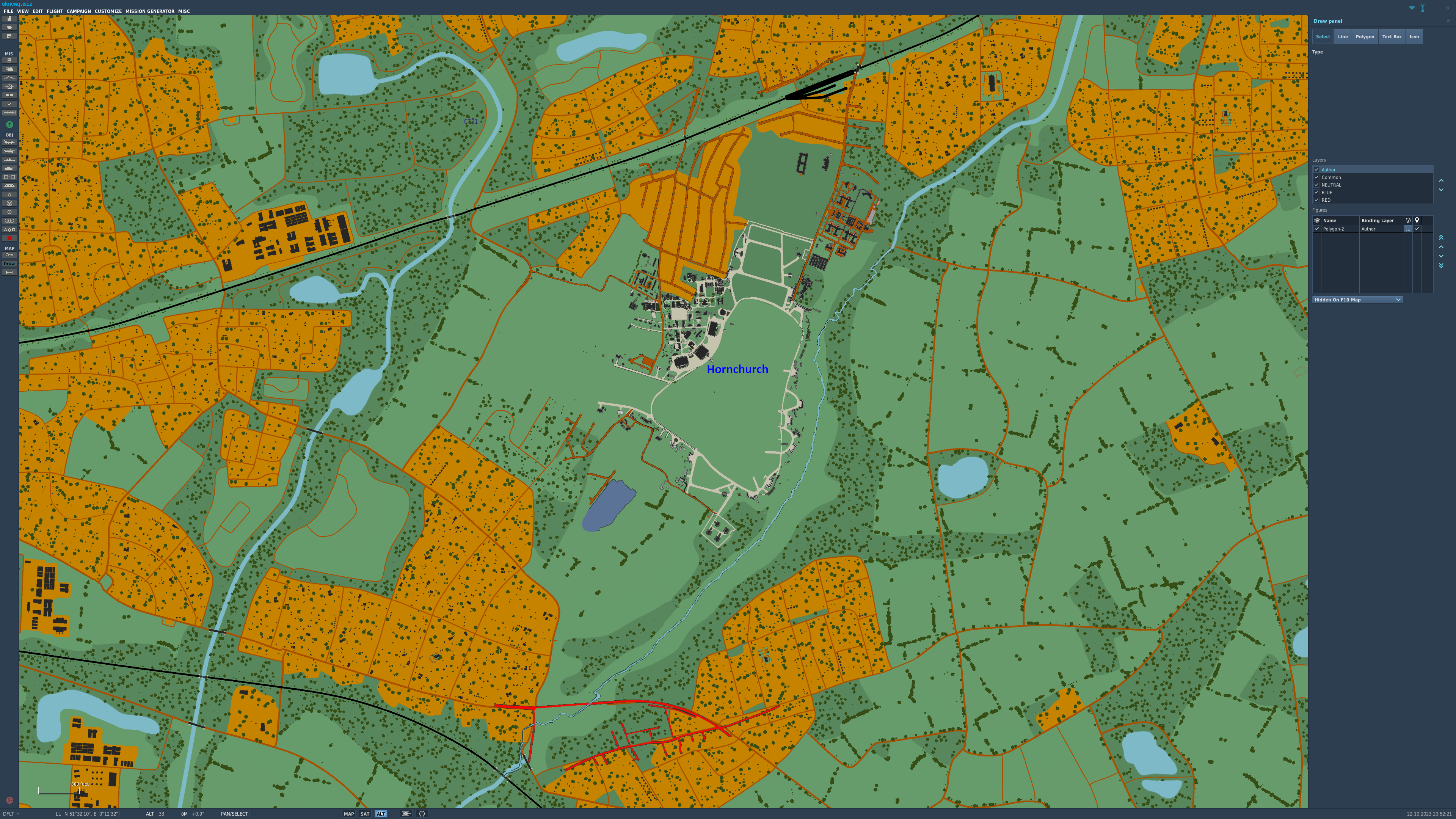
Hi all, going to bring up the hardly noticed topic of Hornchurch Aerodrome. I did type 2 massive paragraphs about this airfield and why it should be added however upon posting I was left with just the images and all of my text gone. Long story short, top picture is from compiled Historic England imagery that I had to pay for and edited into a more simple format of basic colours, ie making map an easier task for where everything should go/ what specific building they such as Type C Hangar, fighter dispersal, gun points etc. The lower picture is of my edit of the DCS Normandy map with the highly detailed and accurately positioned Hornchurch Aerodrome as it was in 1946 (hardly changed in 1944). What was noticed is that on the original DCS map, the roads and buildings become fantasy/random as soon as they enter the boundary of the airfield if that makes sense. Outside the airfield the roads are somewhat correct to how they are.

- 1 reply
-
- 1
-

-
Whilst that is correct that just prior to the June 1944 main operations had ceased, the airfield did remain an active airfield but at a reduced capacity. Soon after June 1944 the airfield and its surrounding area became the target of the V1 Flying Bombs. At this time Hornchurch became a repair unit for restoring vital buildings in London that had been damaged. Though it was a little later and not entirely on topic, in November 1944, RAF Hornchurch became a marshalling area for handling personnel in transit to and from the front. That is the historical reasoning that is time period correct but the other reasoning is that it just would seem unjustified to leave it out of the map considering there is pretty much a blank spot where it would be on the map in game. Heathrow is included in the map as an unfinished airfield at the time (1944) and other airfields have currently not been included because of the clashing with the Channel map which is understandable I suppose. These are my personal opinion but I definitely believe Hornchurch needs to be considered, even just for it to exist as a physical airfield. If I knew how to make it myself I would but I imagine Id have to work for Ugra Media lol
-
I've been following the progression of the DCS Normandy 2.0 expansion and the obvious excitement that goes along with it. With regards to the aerodromes on the map I am aware that there are going to be many more airfields to come as the map gets closer to completion but as of yet there is no mention to be seen or heard of this airfield. The reasons are numerous, firstly its a personal connection as I and my parents have lived in and the vicinity, although that's not a solid reason. RAF Hornchurch (which prior to WWII was a RFC aerodrome known as Sutton's Farm), alongside Biggin Hill, played a hugely vital role in the defence of London as it was the front line for the Luftwaffe's bombing raids. The airfield lived its prime during WWII when it was home to many well known squadrons such as 64sqn, 54sqn, 603 sqn, 74sqn and 222sqn to name a few. The most famous Spitfire flying today is MH434, which lived at Hornhurch, the MKII, P7350 was also based at Hornchurch, the list goes on how much went through Hornchurch but come 1962, the Air Ministry rendered it surplus to requirements and sold the land. Following the years after, the former airfield went through its brutal death of flattening and then gravel extracting which has made the airfield near unrecognisable today aside from a few structures here and there with the largest of those being the single dispersal pen being used as a car park to Hornchurch Country Park. Recently a museum has emerged to help preserve the history of the once great airfield while more of the physical airfield slowly disappears from memory as well as the visitor center which also represents some of the history there. In the digital world, RAF Hornchurch has had a couple attempts at being represented, namely IL-2 1946 (as a mod) and FSX (as a mod), so I feel it is only right for DCS to fill that spot to accurately represent the airfield and the surroundings obviously in its latter appearance in 1944. I imagine it will be a difficult task with the limited reference available however I will add photos and site plans (plus links) to assist. Should this get considered, however long it may be, many hours of flying will be made and I will have a strong heart for this community, apologies for the begging. Currently on the Normandy 2.0 map, the location of Hornchurch has a loose resemblance and there are clearly some modern day road layouts visible but as it is beta this is subject to change I imagine. Here are some pictures for your viewing plus a link to a half hour silent film of the airfield in 1942 https://player.bfi.org.uk/free/film/watch-64-squadron-at-raf-station-hornchurch-1942-online I most gratefully hope to see this airfield added to the map at some stage to be the best representation of it to date as Im already most impressed with the current airfields as they appear currently. Thank you