
qacarxan
-
Posts
15 -
Joined
-
Last visited
Content Type
Profiles
Forums
Events
Everything posted by qacarxan
-
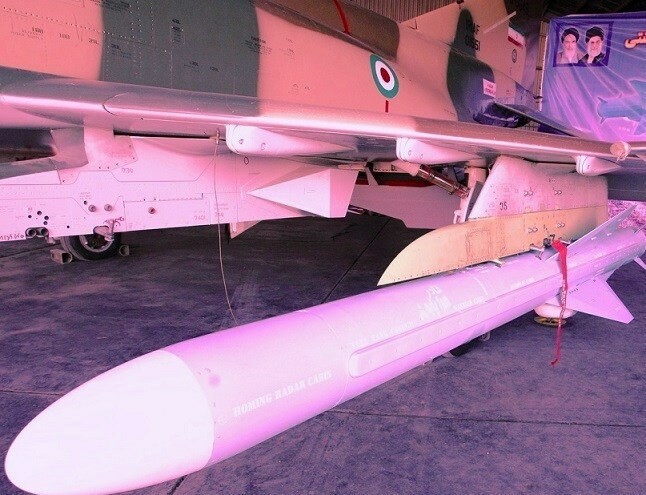
I'd be very excited for more FF REDFOR based on this line of reasoning. And additions to extant REDFOR like Iranian F-4s carrying C-802s, F-14s carrying Fakour-90s, etc! I'm not very excited about the type of aviation an F-35 offers, but I will be happy to have a vanilla AI version to test out air defense systems in the Syria and Iran maps.
-

CM-802AKG Ignores Cruise Alt Settings/ Incorrect speed
qacarxan replied to tekwoj's topic in Weapon Bugs
It would be great if this issue could be addressed. It's been a problem for quite a long time. -
Old topic but it brought up an interesting question for me--seems like IRL, even very high-tech air defense systems in eastern Europe are having a hard time tracking or shooting down glide bombs. Theoretically, I think the GB6 is stealth, and the LS aren't, but would it make sense for all of them to not be tracked by most radar systems in game?
-
Zahedan airport is in the bounds already and while not a permanent base for the IRIAF, it is used as needed for countersmuggling or border patrol missions. Same idea, but perhaps easier to add.
-
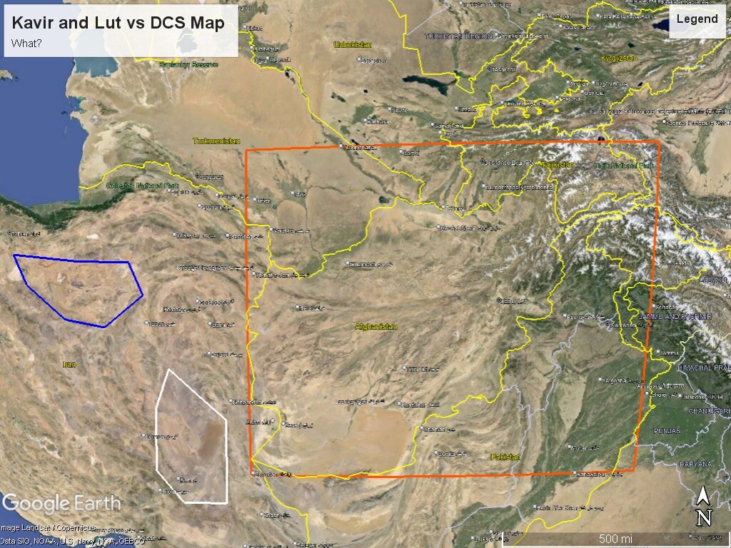
I'll take this opportunity to point out for the third time in this thread that Khorog Airport is in Tajikistan, not Afghanistan, contradicting the statement made by @BIGNEWY that "airfields are only planned within the borders of Afghanistan. There are currently no plans to add airfields from neighboring countries." Unless there is an identically-named Khorog Airport across the river from Khorog, Tajikistan and its co-located Khorog Airport (ICAO: UTOD), there is already an airfield from a neighboring country on the planned map. It's misplaced on the map if it's showing as inside the border of Afghanistan. I'd really appreciate clarification from ED about this, as well as the mentions of the Dasht e Kavir and Dasht e Lut, both of which are outside the boundary provided by the announcement map (being deep in Iranian territory) but are mentioned in the press releases.
-
You already have Khorog on the map you posted, which is in Tajikistan.
-
The FAQ says that, but the map has Khorog Airport in Tajikistan, so along with my question about the Kavir and Lut deserts, I have to say there are some geographical mistakes being made somewhere in here. Would have loved just a few more bases though for infinitely more gameplay. Peshawar: JF-17 Black Spider squadron Termez: Soviet and US operations Zahedan: Iranian F-4s, F-1s, maybe F-5s (can't recall for sure on the latter) operations against smugglers and Taliban
-
Quick question: the Dasht e Kavir and Dasht e Lut are deep in Iranian territory, not in Afghanistan whatsoever, and thus are nowhere in the area delineated in this press release. Is this statement inaccurate or is the map in the press release inaccurate? One of them has to be. Looking forward to getting the map either way, but would love some clarity. See the map below for Kavir (blue) and Lut (white) vs the rough area of the DCS map.

-
I am very excited for this map. While it's been stated that the map will focus within the borders of Afghanistan and very possibly won't have much from outside western Afghanistan for the early access version, the announcement listed the Dasht e Kavir and Dasht e Lut, both of which are deep in Iranian territory and not in Afghanistan whatsoever. In the case of the Kavir, you're only 100km from Tehran itself on the western edge of that desert. For the Dasht e Lut, you're still about 100km within the Iranian border from Afghanistan. They're both well outside the orange box delineating the map area in the first announcement (see the rough areas in the attached image). I'd be very excited if that region is indeed going to be included in the map at some point, as I'd love to recreate Iran's anti-smuggler and anti-Taliban COIN operations of recent decades. So I'll ask--the verbiage in the announcement seems to contradict the within-border focus and the delineated map area if those two deserts are part of the map. Are they indeed going to be included in the finished release (doesn't sound like it for the EE I am guessing)? Thanks!
-
My pleasure! Regarding accuracy based solely on GLONASS, what I shared above also addressed the relative precision of GLONASS itself and not just a jamming scenario. To whit: "When solely relying on a real-time fix from orbiting satellites, all four GNSS [i.e. GPS, Glonass, Beidou, Galileo] have roughly comparable performance, given that GLONASS is closing the performance gap." Source: https://ndupress.ndu.edu/Media/News/News-Article-View/Article/2999161/beidou-chinas-gps-challenger-takes-its-place-on-the-world-stage/ So there's still no justification for unilateral GNSS degradation for contemporary mission settings. The difference is a SISRE of 0.6m for GPS vs 2.3m for GLONASS. If they want to really get petty about it, they could make redfor munitions 1.7m less precise, on average. That's still minute-of-tank for my gameplay purposes!
-
Last I checked, the US F-4 inventory didn't include R-73s, the Ghassed guided munition, or the Qader C-802 AshM/Cruise missile derivative, so while I'm delighted to have any F-4E from Heatblur, I also know that less is not necessarily more. I'd also point to things like the Grom in the Mig-21 module or the Sea Eagle for the C-101, neither of which are historically accurate IIRC--if that's the case, they're outright "artistic license" for the sake of player entertainment and Digital Combat Simulation rather than Digital Cockpit Simulation. The munitions we've discussed would not be, with real-world empirical evidence of use. They'd be fun to have, add to the Redfor possibilities, and the only counterargument is a question of switchology at this point. It would be easy to make them toggleable for the cockpit purists. At any rate, it sounds like it's not going to happen, so that's a bummer, but at least we've had a chance to put a word in.
-
Long post but bear with me. If a mission is set in the past few years, there's no justification for ED to downgrade red more than blue based on everything I've read. For context, my work involves extensive use of remote sensing and GPS in remote regions, though I am not involved in the design or deployment of positioning systems, or any military application of these technologies (I do agricultural and ecological research). At any rate, to the sources: "In the present study, the Signal-in-space range error (SISRE) computation method for different types of navigation satellites was presented. The differential code bias (DCB) correction method for BDS-3 new signals was deduced. Based on these, analysis and evaluation were done by adopting the actual measured data after the official launching of BDS-3. The results showed that BDS-3 performed better than the regional navigation satellite system (BDS-2) in terms of SISRE. Specifically, the SISRE of the BDS-3 medium earth orbit (MEO) satellites reached 0.52 m, slightly inferior compared to 0.4 m from Galileo, marginally better than 0.59 m from GPS, and significantly better than 2.33 m from GLONASS." (emphasis mine) Source: https://www.nature.com/articles/s41598-022-12012-y "Pakistan also signed a first-of-its-kind agreement with China in 2013 to install five BeiDou ground augmentation stations and one processing center, allowing greater accuracy in the country." Note: That's mostly just relevant to our own module and the Persian Gulf map. But there's more on a global scale: "When solely relying on a real-time fix from orbiting satellites, all four GNSS [i.e. GPS, Glonass, Beidou, Galileo] have roughly comparable performance, given that GLONASS is closing the performance gap." Source for both: https://ndupress.ndu.edu/Media/News/News-Article-View/Article/2999161/beidou-chinas-gps-challenger-takes-its-place-on-the-world-stage/ "General Holmes, who leads the Air Force's Air Combat Command (ACC), was responding to a question about military communications system vulnerabilities at a conference in Washington, DC. And he opined that the Air Force should be able to use the wide variety of commercial communications paths available. 'My U-2 guys fly with a watch now that ties into GPS but also BeiDou and the Russian system and European system... so if someone jams GPS they still get the others,' Holmes said." Note: the article goes on to explain that General Holmes did not get his facts straight and the watch compares only GPS and Glonass, but it brings up a wider point; namely, the use of multiple GNSS in degraded situations. Chinese geoscientists have also done extensive research on hybrid systems and their accuracy, so this idea of combining and comparing is not news to them either. Source: https://arstechnica.com/gadgets/2020/03/why-are-u-2-jet-pilots-wearing-garmin-satellite-navigation-smartwatches/ Bringing it back to the JF-17, the Minhasians conducted a cross-border strike into Iran in January. Some news agencies claimed they used a glide bomb similar to the in-game LS-6 but with a rocket range extender and the imprecise CEP of "less than 20m" with GPS and INS guidance. The targets--a Baluch separatist group--confirmed their people were hit (and unfortunately many reports confirmed civilian deaths as well). There are conflicting reports as to the distance from which the weapons were deployed. I haven' seen any confirmation from the Pakistani government as to the weapons used; just a confirmation from the official JF-17 website that the Minhasians were part of the strike. If the bomb is indeed GPS-guided, that could be an argument for degraded accuracy if flying against bluefor, but if they meant GNSS-guided with Beidou and just said GPS the way Americans say "kleenex" for all tissues, then we're back to the point about Beidou. But again, in this instance, whatever munitions they used hit the target, per their own enemies' public statements. Sources: https://newsguru.pk/pakistans-iran-strike-unveiling-the-weaponry-details/ https://jf-17.com/2024/01/18/jf-17-fighter-jets-take-charge-in-swift-response-launching-powerful-strikes-against-terrorists-inside-iran/ At any rate, based on research showing accuracy of the latest generation of Beidou equivalent to or slightly better than US GPS, as well as statements from US personnel and defense analysts above, I'm not sure what justification there can be for a biased GNSS default in DCS for any mission set in the past few years. Older than that, fair enough, but not since 3rd gen Beidou came out. Glonass is improving too, according to the NDU.
-
I'd be happy to translate if it meant more options. I'm sure many other Farsi-proficient or fluent players would feel the same. Some of it really doesn't need much, though, like the C-802 example here, or the R-73. We already have those missiles in-game, we already have documentation of use on Iranian F-4Es, including video evidence; just need to connect the dots at that point. Claims that it's probably just an experiment lack proof of that assertion, whereas the news articles from Iranian government agencies say some of the upgrades are a military-wide upgrade. So I'm not sure why that would be an issue of documentation at all, really, unless video proof and state news agencies are not considered documentation. It's also worth noting that many Iranian press outlets are officially affiliated with the IRGC or other government and military branches, so a press release from them is a direct statement from the respective branch of government/military. Hope that offers some avenues of exploration or clarity. I love that DCS strives for true simulation rather than guesswork. A big part of my IRL job is scientific research, so sources and empirical evidence matter to me a great deal. Unless we need a signed affidavit from a Western intelligence agency for proof, I think we can meet a rigorous standard while still expanding some modules to have interesting real-world adaptations born of necessity, like Iran's interesting collision of Western and Eastern technologies. Many modules have made some compromises for playability or combined different blocks into one module; this wouldn't even be stretching that far imo. Of course, the final say is Heatblur's, and I'd personally rather have any F-4 at this point than delay them with more work, but maybe once they have a moment some months from now, it could be considered.
-
While we are on the wishlist, IRIAF have successfully fired the C-802 antiship missile from the platform as well. More upgrades are discussed here: https://www.tasnimnews.com/fa/news/1398/12/18/2217609/گزارش-تسنیم-از-رادارهای-هواپایه-بومی-جهش-بلند-در-توان-رزمی-اشباح-ایرانی-چشم-و-پنجه-عقاب-ها-تیزتر-می-شود There are youtubes of the successful test firing. I doubt we'll get these since many developers seem reluctant to model any Iranian adaptations, which is frankly a huge loss for the underrepresented REDFOR modules that everyone is always complaining about. If they did, we'd have F-5 with modernized radars and Russian missiles and dual vertical stabilizers, these F-4s, and F-14s with not just the Hawk mod but also the Fakour Aim-54 copy/mod. I appreciate that a lot of this is undocumented, but not all of it is. I know Heatblur has the IRIAF F-14 on the to-do list, so hopefully that will address some of our wishes!
-
Firstly, huge congratulations and thank you to Deka for making this module. It was my first FF and is still my favorite! I was just wondering if there's any possibility of changing the sound of the gun to make it less, well, cartoonish and more like the real one? It's one of the very few immersion-breaking things about the module. I've noticed a lot of the 23mm guns in DCS have a not-very-realistic sound, so perhaps this is not something Deka can address because it's an ED thing? Apologies if so. Something like this would sound great since it's the real BRRRRT of the beloved JF (hope it's ok to link YouTube here):