CASoldier2014
-
Posts
190 -
Joined
-
Last visited
Content Type
Profiles
Forums
Events
Everything posted by CASoldier2014
-

Aircraft flight path on the 'Abris'
CASoldier2014 replied to CASoldier2014's topic in DCS: Ka-50 Black Shark
+1 You are right. I still have some faith left that it's possible to disable this feature, though I can fly with it - it's not a big deal. Thanks for your effort, guys! :) -
So I've seen a lot of threads about how to do this, but none of them actually did what the title says: Set up a custom FOV for your Numpad Enter key All of those threads said that you have to open some sort of file, edit values, etc. Well I have a simple in-game way of doing this! :D I don't know if a tutorial thread like this already exists. If it does - excuse me :music_whistling: I just want to share this easy to set up finding. Let's get to it! First of all you have to disable the use of default views by doing this: 1. Go to X:\\DCS World\Config\View 2. Open up View.lua 2. Find the line: UseDefaultSnapViews = true and change it to UseDefaultSnapViews = false .Then save it and all that good stuff.. :) Since we got that set up, now we have to launch our game. Now, when you get in your cockpit do the following: 1. Center your view 2. Zoom in or out to your preferred FOV 3. Press RALT+Num0 to save your view INCLUDING your FOV Now you're good to go! Try to zoom in or out and then press Numpad Enter. You will notice that it switched back to your FOV that you just set. :) Warning: If you have TrackIR, you will probably need to shut it off while doing this, otherwise it won't save the view the way you want it! If you need official in-depth info on this go here Hopefully this was helpful to some. Let me know if this was usefull ;) -CAS
-
Aircraft flight path on the 'Abris'
CASoldier2014 replied to CASoldier2014's topic in DCS: Ka-50 Black Shark
I always manage to set up everything (including the map and such) before entering the FEBA EDIT: Again, I have my own ways, you have your own ways, guys. Let's not go off topic here. If it's not possible to disable this feature, just tell me :) -
Aircraft flight path on the 'Abris'
CASoldier2014 replied to CASoldier2014's topic in DCS: Ka-50 Black Shark
For example, I zoom in with my 'Abris' so that I can see the terrain better and then I follow the contours of the terrain and let it give me points of reference like towns, roads, railroads, rivers, etc. (this doesn't always work, though). OR I use my DLINK Initial point function on the PRTz Data Link Control Panel (the upper right-hand side button) to mark an IP/Hover Point. In conjunction with the DLINK automatic ingress to target function and “АДВ” (automatic auto turn to target) I can make my KA-50 automatically fly to that point. Of course, I need to be at a certain aspect from the DLINK Initial point, but it's easy as pie :geek: -
Aircraft flight path on the 'Abris'
CASoldier2014 replied to CASoldier2014's topic in DCS: Ka-50 Black Shark
Believe me, I understand how valuable it is to others, but I have different methods that are also effective. -
Aircraft flight path on the 'Abris'
CASoldier2014 replied to CASoldier2014's topic in DCS: Ka-50 Black Shark
That's true, but I can easily remember my path and the Flight Path on the 'Abris' just clutters my screen :) -
Aircraft flight path on the 'Abris'
CASoldier2014 replied to CASoldier2014's topic in DCS: Ka-50 Black Shark
I know. But I don't need it, since it doesn't bring any use to me. -
Aircraft flight path on the 'Abris'
CASoldier2014 replied to CASoldier2014's topic in DCS: Ka-50 Black Shark
OK thanks :) -
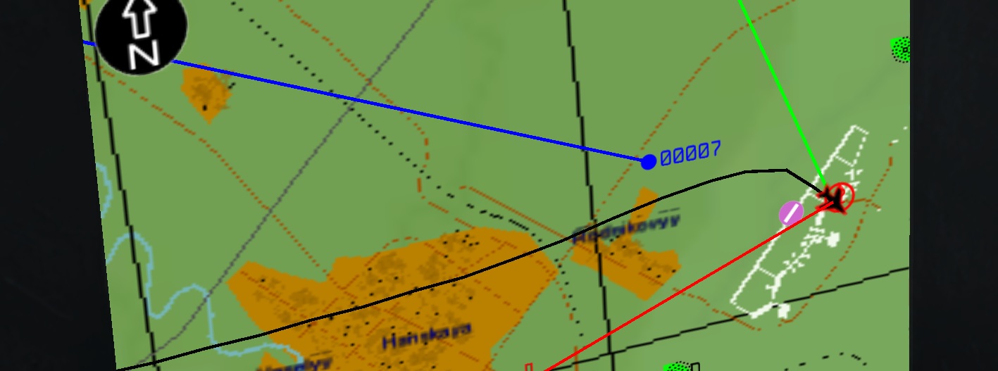
As you can see in the photo below, the 'Abris' draws a black line that indicates your aircraft's flight path. I find this feature useless for me, because it only clutters my 'Abris's' screen and nothing more. I tried disabling it, but I found no info in the Flight Manual (or maybe I just don't know how to look for stuff ;D) Does anyone have any suggestions on how to disable/reset the flight path line? Thanks! :)

-
How Real is it and how effectiv is the real A-10C?
CASoldier2014 replied to EF2000's topic in DCS: A-10C Warthog
You are very wrong.