IAF.AssafB
-
Posts
65 -
Joined
-
Last visited
-
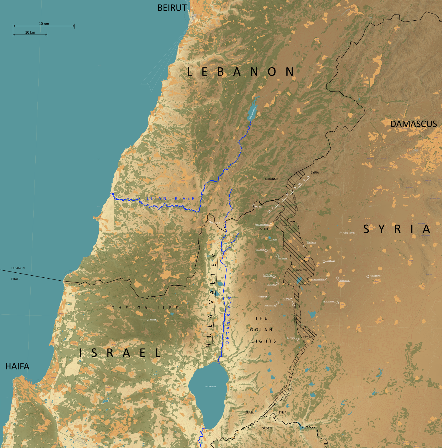
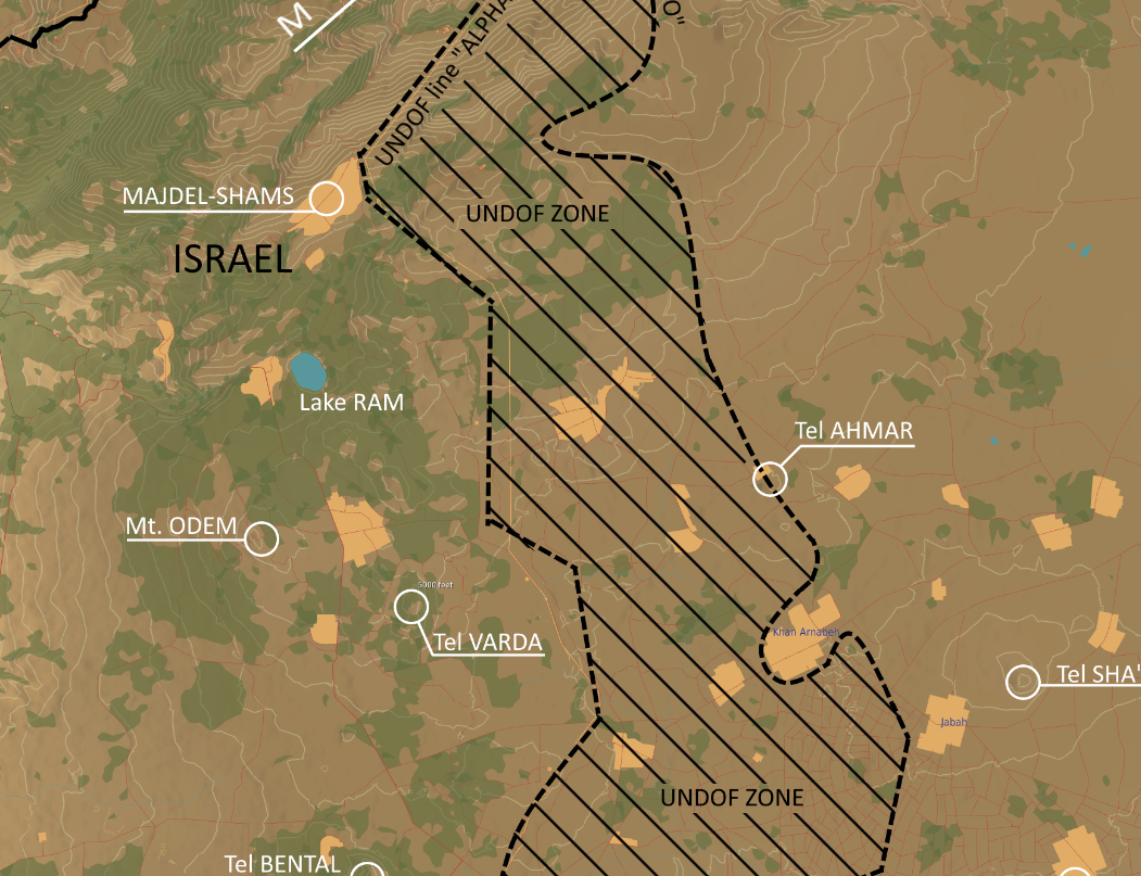
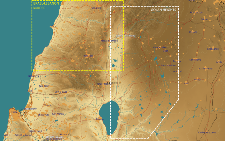
As part of a campaign we currently run in the 132nd Virtual Wing I've prepared this set of CombatFlite file and map to assist in better understanding of the complex theatre of Northern Israel and its borders with Lebanon and Syria. Living not too far away from that area and having a certain degree of personal familiarization with it I figured it might be nice to have a tool to provide a more realistic background of that area. The ZIP file contains a CombatFlite file with the following bits: 1) A more precisely plotted international border between Israel to Lebanon and Syria. The plot follows RL borderline more closely than the general border as given in the DCS world map. For the Israeli-Syrian border, both line "ALPHA" and line "BRAVO" are given with "UNDOF-ZONE" between them (The demilitarized zone established as part of the ceasefire between the two countries in 1974). The plot also includes a short portion of the Jordanian-Syrian border and the Syrian-Lebanese border. 2) Outposts belonging to the UN peacekeeping forces along the two borders. Those outposts are marked in the CF file and provide the location of the outposts as built in DCS (not fully following RL position but close enough , and as those outposts bare UN markings they can be quite useful for some interesting scenarios). The outposts are divided to UNIFIL ("United Nations Interim Force In Lebanon") and UNDOF ("United Nations Disengagement Observer Force") 3) Key terrain features including a few mountains on the Israeli side of the border as well as a few dormant volcanic mountains along the Israeli-Syrian border that - due to their tactical importance as vantage points - played a key role in previous conflicts. 4) Finally, a high-resolution 50mb map made out of DCS-World map overlaid with some labeling and markings aimed at assisting with the understanding of the area. A suggested method to get to know those features is to create s flight and a flightplan in CF from the enclosed file, export it into a MIZ file and just jump in and fly it/ DISCLAIMER - I do not claim this map and details are 100% true-to-life. It was done based on publicly available data and based on personal familiarization with the area. There are many other features and landmarks worth mentioning which I might add later on. Everything's in the file section, right here: https://www.digitalcombatsimulator.com/en/files/3322170/ Have fun. Assaf

-
Script wanted: more realistic artillery effects on SAM units?
IAF.AssafB replied to IAF.AssafB's topic in Mission Editor
Thanks! Unfortunately I'm nowhere near being able to alter/modify any existing script (Have only used very basic MIST functions and that, too, took lots of trials and - mostly - errors...). I therefore look for a solution I can grab and implement. -
Hello! I'm looking for a script / solution which would simulate artillery/impacts effects better than what's currently done in DCS. My scripting knowledge is just about nil and I would really like to create some interesting scenarios for MP missions involving pilots, tactical commanders working together. What I have in mind: An artillery round impacting inside of, say, 50 meters from a SAM radar unit is likely to have no effect on the unit in DCS but I would very much like to see that unit becoming inactive (Radar dish stopping for "x" amount of minutes - perhaps a random period that can be configurable?). Then the unit would become fully active again. While at it, if the unit suffers any actual damage but still "alive" by DCS standards it would be incapacitated for even longer time. I imagine a near miss of a 155mm round would cause some damage to radar equipment, communications going offline, scare the living hell out of its crew and alike... If possible, would be great to have similar effects by bombs/missiles impacting close to those units, too. EDIT TO ADD: the intent is for the artillery aiming and firing to be done by a player and not AI (This is in order to allow a coordinated work between pilots and tactical commanders in suppressing and destroying those SAMs sites) I've searched for existing scripts but found none. If anyone could either point me to anything available or even come up with a solution I'd be most grateful. Thanks!
-
Splash Damage 2.0 script (make explosions better!)
IAF.AssafB replied to Grimm's topic in Scripting Tips, Tricks & Issues
Hello and thanks for sharing! I wonder if this script can be used to include artillery shells as well. What I have in mind is to be able to use artillery for suppression of SAM sites if hitting anywhere around them (Not even causing actual damage but to mimic SAM crews being shocked and unable to function for a minute or two....stuff like that). Specifically looking at 155mm arty (PALADIN and MSTA) as well as 120mm mortar rounds. With scripting knowledge which is next to nil I'd sure appreciate your experts' opinions Thanks ! -
Hi, Added 3 more cards covering some air-defense vehicles: SA-9 and SA-13 SA-15 and SA-19 SHILKA and SA-8 All cards are zipped in the files section at: https://www.digitalcombatsimulator.com/en/files/3310728/ Fly safe, Assaf.
-
Hi, This is to let you know of a couple of high-resolution PNG maps created for the Syria theatre. The ZIP includes high resolution maps (Scale approximately 1nm/335pixels) created from stitching screenshots of the DCS F10 map (a LOT of them...) The reason I did it is because unlike Google-Earth/Combatflite maps, the DCS map isn't 1:1 true-to-life and the differences - however small - may prove critical when planning missions involving ground units/objectives, close-air-support coordination and alike (Location and layout of roads, villages, forests etc). Obviously the maps can be cropped as needed to create specific high-resolution maps for coordination of air-ground operations. It is my hope that those maps be of use by mission creators, planners as well as for JTAC/FAC(A) roles for creating immersive scenarios. The Lebanon-border map also shows rough location and names of UNIFIL (United Nations Interim Force In Lebanon) and IDF (Israeli Defense Force) outposts and bases along the border and in Southern Lebanon. This can assist mission-creators add the outposts to their missions and increase immersion and realism (For example, having to consider rules-of-engagement issues in areas where UNIFIL personnel might be present on the ground). https://www.digitalcombatsimulator.com/en/files/3313801/ Have fun, Assaf.
-
Script Function: Check presence of certain number of units of several types or groups within a zone. Check is done in varying intervals (20 seconds for ground units, less for airborne units). Script Tool: MIST Notes: not included in DCS
-
Thanks for the kind words gentlemen! dorianR666 thanks for the tip. Added to the files section, too. (Although I should make a mental note of updating it whenever updating "my" google drive folder. Cheers, Assaf.
-
Hi, For pilots who are into air-to-ground missions, I've created the following kneeboard cards. I've focused on types of units that are most common on our 132nd Virtual Wing's trainings and combat missions. I specifically avoided SAMs/AAAs etc as those air-threats are already addressed by other content makers (Well, I ran across a few while googling :)) The intent here is to assist in ID'ing what the pilot is seeing so as to be able to tell a friend from a foe, and to have a clear idea about the type of ground force he (or the JTAC he's supporting) is up against. I hope it would be of assistance. Fly safe, Assaf. PS - not sure if that's the most appropriate forum for this. If not, then my sincere apologies and I'd be grateful if this can be moved to a suitable one.
-
Messages to Combined Arms? Hi, Trying to set some messages to be delivered to CA players. When in the msgFor line I set {CA = {'blue'}} The CA player receives a ton of messages. See screenshot https://imgur.com/a/nma0KtL (The screenshot is when using mist.msgLL but the issue is the same with simple MIST messages as well) Is this normal? Have near-zero LUA understanding so I don't really know what am I looking for:huh: Thanks!
-
mist.makeUnitTable Greetings, (I guess the following is roughly 50% general LUA and 50% MIST issue...) I wish to define a table which will contain specific unit names (specific MBT's and IFV's for that matter) From my extremely (!!) basic understanding in both LUA and MIST, I understand that mist.makeUnitTable should be the way to go. Could anyone point me to an example of how the code should look like? I figure I need the table name to be included later on in other functions (units in zones etc) but how do I practically define the table name and its content within DCS? Thanks! Assaf.
-
Hi, There're functions for this available in MIST (by Grimes). I'm terribly incompetent when it comes to codes/scripting and using MIST is about as far as I'm able to get in this field (tried to get into MOOSE but with no success. I'll have to give it another shot sometime) From your description it seems that you could use mist.flagFunc.units_in_polygon http://wiki.hoggit.us/view/Units_in_polygon HTH, Assaf.
-
AI task to explode in the ground or ram building
IAF.AssafB replied to rnm2000's topic in User Created Missions General
Hi, I've done a similar thing (with triggers, not scripts). Could make a "civilian" aircraft fly low over my airbase, and as it passed low over the tower (using its waypoints with a low altitude) it triggered some explosions (took out buildings, fires and stuff:thumbup:) Can try and find it if you think it'll help, Cheers, Assaf -
Is there a target range mission...
IAF.AssafB replied to kipblair's topic in User Created Missions General
Another one here, It is rather old, and I hope there's no bugs in it (not tested on recent DCS updates). If there's anything wrong with it please accept my apologies and let me know so that I'll fix it :cry: Pick any of four A-10C groups, each with different type of target (from the basic stuff to the most dangerous ones) as follows: Pony - 6x groups of tanks, trucks and alike, 3x groups are positioned out in open fields, the other 3 are in inside vallies Enemies are not firing anything back at you Each group will re-appear once destroyed Note: WP#2 (INGRESS) is out over the sea for observation and targeting before moving in to engage BUSTER - 4x vehicle groups including some AAA. 2x groups out in the open, the others inside vallies Targets are driving around and will return some AAA and gunfire (no missiles threat) INFRA - two target areas with some IR SAM threat of all kinds as well as some AAA units SEAD - 4x target areas: SA8, SA3, SA15, SA6 In each area, once the threat has been neutralized (i.e search & track radar of an SA6 was destroyed, rendering the battery useless) then the target will reappear someplace close to the original site (allowing for some practice of locating the threat as well as engaging it Have fun! Assaf. A-10C TRAINING WORLD DAY V2.miz -
A pleasure, thanks! Thanks and have fun! Cheers, Assaf.