Search the Community
Showing results for tags 'navaids'.
Found 4 results
-
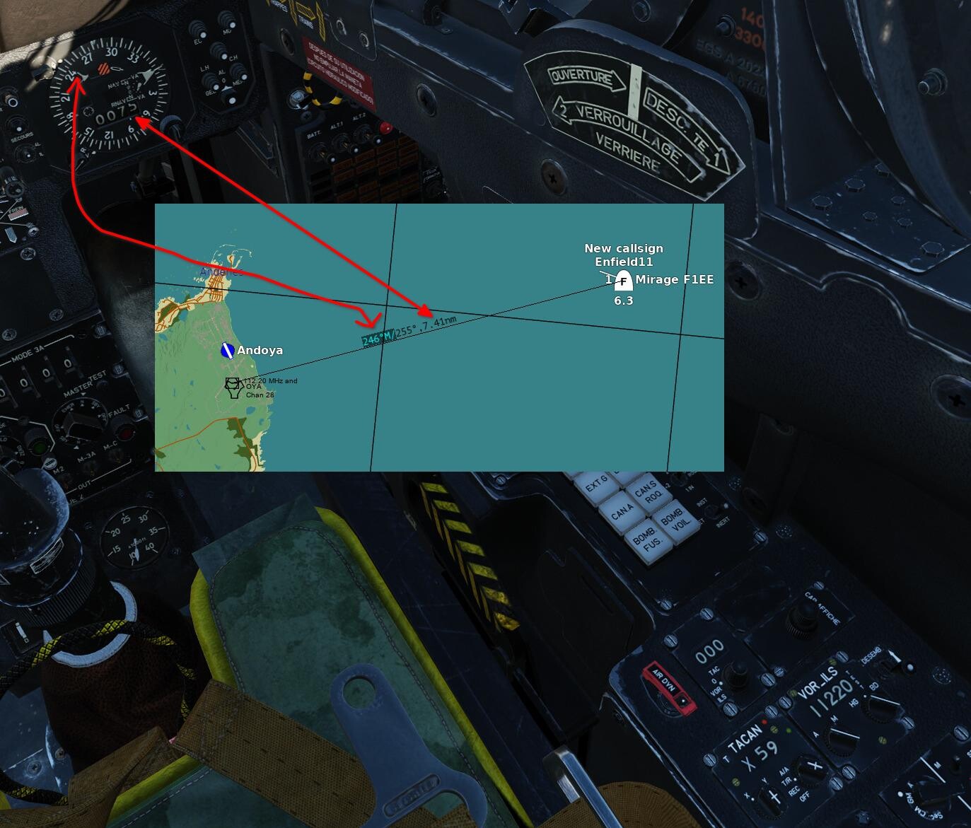
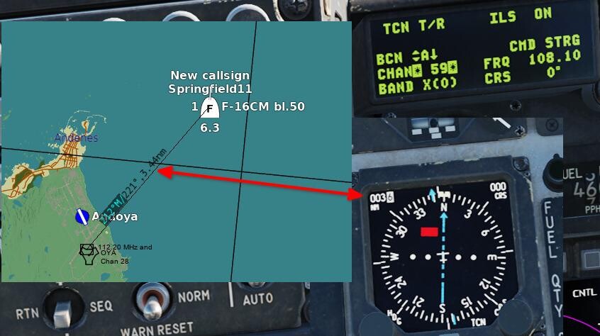
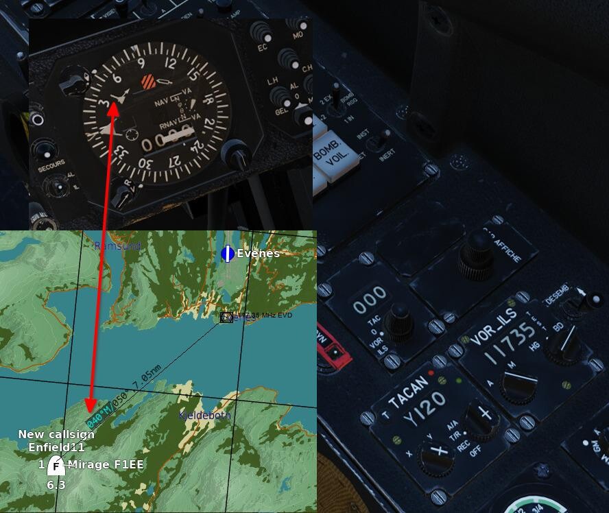
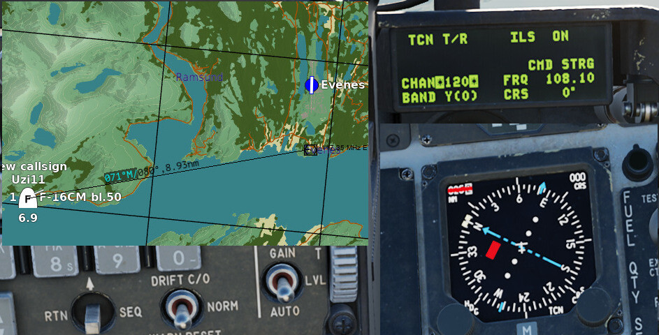
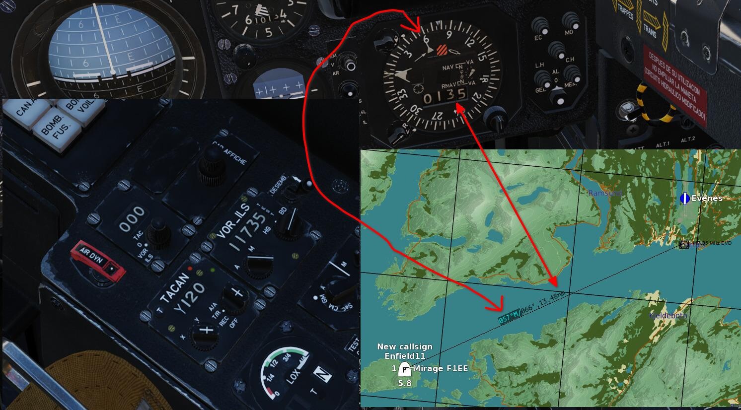
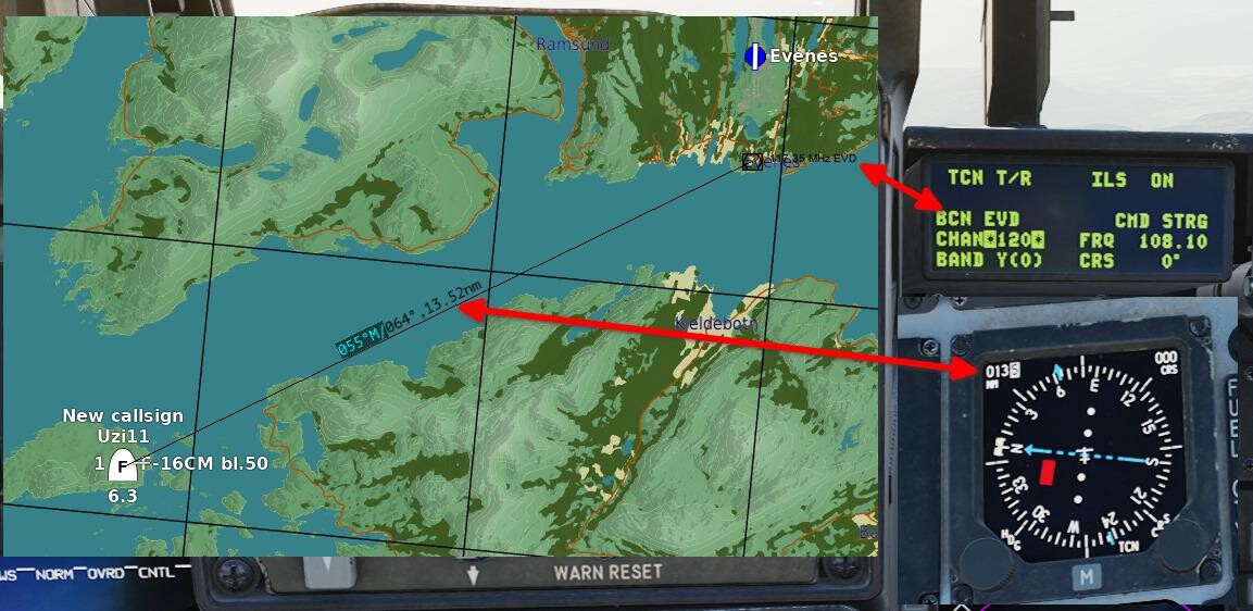
DME not working for Y channels has been an issue for years (always?), and after some digging in the LUAs, I think I have identified why, and how to fix it. First, in order to avoid confusion (which I have seen a bit of when VOR, DME and TACAN is discussed in the forums), here is some technical info (feel free to skip this paragraph if you already know this): VOR: an omni-directional beacon operating in the VHF band between 108 and 118 MHz, that radiates 360 radials you can tune your receiver to intercept. It also gives you the direct bearing to the beacon. The "R" in name VOR can be a bit of a misnomer, since a VOR does not provide range info, but it is due to the term "radio range" being used as a colloquial term for radio naviagation aids back in the day. DME: provides the slant range between the aircraft and the beacon. Each beacon operates on two frequencies in the 960-1215 MHz range; the interrogation frequency (transmitted by the aircraft) and the reply frequency (transmitted by the beacon), which are separated by 64 MHz. The frequencies are never set manually, instead they are assigned fixed channel numbers and a mode (X/Y) for ease of use. The X and Y modes refer to different spacing between the pulses used when determining the range, allowing twice as many DMEs to operate within the same frequency band. VOR/DME (or VOR+DME): A VOR co-located with a DME, giving you both bearing and range info. The VOR frequency and DME channel is paired according to ICAOs Annex 10, and every DME channel except 60-69 has a paired VHF frequency (either localizer or VOR). TACAN: This is where it gets a bit more complicated. A TACAN is a DME where a rotating, slightly directional, antenna generates a rotating radiation pattern that aircraft equipped with TACAN can use to determine the bearing to the beacon (like a VOR). All aircraft with TACAN can get the range to a DME and all aircraft with DME can get the range to a TACAN, but only the combination TACAN/TACAN will give you range and bearing. VORTAC: A VOR co-located with a TACAN. Works just like a VOR/DME for aircraft without TACAN, and like a TACAN for aircraft with TACAN. Now, on to the bugs: Test info: Testet on the following map: Kola, with Evenes VOR/DME (117.35 MHz / 120Y) and Andøya VOR/DME (112.20 MHz / 59X). No unofficial mods installed (before testing my proposed fix for the bugs, which requires changes to BeaconSites.lua and BeaconTypes.lua). The frequency / channel pairing is according to ICAO Annex 10. The channels are not included in the beacons.lua entries for the airports, but this parameter only displays the channel number in the ME/F10 map. The actual channel use is set up based on the paired VHF freq. Plane: Mirage F1EE (TACAN for range to DME, VOR for bearing to the VOR) and F16 (TACAN for range to DME (no VOR in the 16..)) F1EE: Evenes: bearing, but no range. Andøya: both bearing and range. F16: Evenes: no range. Andøya: range OK. See \DCS World\Scripts\World\Radio\BeaconTypes.lua and BeaconSites.lua for context (variables, function names etc). Issue 1: The function "getPaired_DME_ChannelBy_VOR_Frequency(VOR_freq)" in BeaconTypes.lua returns channel numbers correctly for X channels, but the function return value (return channelX2 / 2 + chStartVal, channelMode) does not take into account that the variable channelX2 is an odd number for Y channels, and thus returns a non-integer channel value for Y. Two examples: #1: Channel 19X: VOR_freq = 108200000 (108.2 MHz) freqToSubtract = 108000000 chStartVal = 17 channelX2 = (VOR_freq - freqToSubtract) / 50000 with numbers filled in: channelX2 = (108200000 - 108000000) / 50000 = 4 Determine X or Y: channelX2 % 2 = 0 => channelMode = X return channelX2 / 2 + chStartVal, channelMode with numbers filled in: 4 / 2 + 17 = 19, X --------- #2: Channel 19Y: VOR_freq = 108250000 (108.25 MHz) freqToSubtract = 108000000 chStartVal = 17 channelX2 = (VOR_freq - freqToSubtract) / 50000 with numbers filled in: channelX2 = (108250000 - 108000000) / 50000 = 5 Determine X or Y: channelX2 % 2 = 1 => channelMode = Y return channelX2 / 2 + chStartVal, channelMode with numbers filled in: 5 / 2 + 17 = 19.5, Y (Non-integer channel number!) The return from getPaired_DME_ChannelBy_VOR_Frequency is used by the function getTACANFrequency, which returns the wrong reply frequency if the channel number you pass to it isn't an integer. Changing the return to "return (channelX2 - channelX2 % 2) / 2 + chStartVal, channelMode" fixes this problem in the tests I have performed. This will give you the DME IDENT tone in the plane (tested in the Mirage F1EE), but no DME distance. The distance problem is described below: Issue 2: The DME part of the "[SystemName.VORDME]" section in BeaconSites.lua only contains the following signals: signals = SIGNAL_VOICE_AM + SIGNAL_DME + SIGNAL_TACAN_X. Adding "+ SIGNAL_TACAN_Y" is required for Y channel DME range (which is the same signal as TACAN range, hence the name). So, TL;DR: these two changes fix the non-working Y-channel DME (actual changes highlighted in green): BeaconSites.lua, change line 403 to: signals = SIGNAL_VOICE_AM + SIGNAL_DME + SIGNAL_TACAN_X + SIGNAL_TACAN_Y, BeaconTypes.lua, change line 199 to: return (channelX2 - channelX2 % 2) / 2 + chStartVal, channelMode Screenshots from my tests: Mode X DME working (+VORin the F1EE): Mode Y DME NOT working before fix (VOR works in the F1EE): Mode Y DME working after fix:

-
hi, i was building a road farp and noticed that if i wanted to take off or land at night on a improvised runway i can't place indicator lights to indicate every important markpoint (runway start-end, a rudimentary ALS, etc etc) so i thing it would be nice (and even low effort) to make small lights that can be placed, not much, just one steady and one flashing, with different colors Because right now we can only land using NVG or flying really low with the landing light on especially with planes that don't have TACAN or any radionavigation aid a dream come true would be a placeable ILS but i guess that is a bit much to ask
-
Hi everyone, This one is a bit of a nitpicky one, concerning a few minor issues at Stanley Airport. A VOR is present that doesn't exist IRL - actually a DME, but doesn't look to be where the VOR is in DCS. The NDB is in the wrong location, has the wrong frequency and has the wrong identifier (though the model is suitable for at least one antenna at Stanley). EDIT: It is located at Port Stanley airport, but likely not where it is depicted in DCS The runway markings are inaccurate There's a set of PAPIs which aren't present IRL. There's a giant lattice tower next to the control tower which doesn't bear much resemblence to the real thing. NAVAIDs, runway markings and PAPIs: Here's a screenshot in the mission editor. Note the VOR, NDB, runway markings and PAPI lights: And here's roughly the same position (though zoomed out) in Google Earth: There's no VOR There's no NDB The runway markings are inaccurate There doesn't seem to be any PAPI lights (resolution of satellite imagery might result in them not being visible). The model of the NDB would be suitable for antenna marked with a circle with an arrow pointing to it (I'm not sure what this is, but the model certainly looks suitable). EDIT said antenna (seen inside the left circle) is an NDB colocated with a DME station, the right circle appears empty in zoom.earth. Speaking of the NDB, apparently Port Stanley airport does have one, but it's located in Port Stanley itself (251° for 2.7 nautical miles from Stanley). Also, the frequency and identifier are both inaccurate. It's currently 314 kHz and "SA" respectively, when it should be 340 kHz and "STA" respectively: Also note how no VOR is marked. EDIT, the above image is inaccurate (out of date most likely). Lattice Tower: Also in DCS is a fairly gigantic red and white lattice tower, adjacent to the control tower. IRL, there is a grey lattice tower but its much smaller Camera position: -camera 88.824506 0.358139 93.737658 -cameradir 0.150190 -0.988621 -0.008457: The tower is next to invisible in Google Earth, but I did find this image of it: Looks to be about double the height of the control tower. In DCS however, this is what it looks like (camera position: -camera 88.888079 0.022867 93.797900 -cameradir -0.904668 0.174173 -0.388895): The other problem with this tower in particular is that its LODs make it next to invisible until it suddenly pops into view at around 1 km away (though at least, unlike the Marianas, it's not near on an approach path like Saipan's NDB).
-
Hi everyone, Would it be possible to have NAVAIDS be unit that can be placed directly into the mission editor? Focusing on NAVAIDs that are portable IRL, but I'd extend it to NDBs, VORs, ILS', marker beacons, airfield beacons (if we get them) etc. This would make sense as some of the NAVAIDS that we have at present actually have mobile forms. It would also simplify the creation of RSBN/ARK locations for the MiG-21bis and TILS locations for the AJS 37 Viggen. Once the unit/object is placed in the mission editor, the user should have the ability to define a frequency/channel and power (though if we're going on a certain system, the power should default to the real system's value) etc, in the same fashion as select frequency that we have currently. For ILS/PRMG/TILS it might also be useful to specify a glideslope angle within a certain range. It would probably be good to have a checking system to ensure that a selected frequency/channel etc isn't already taken by something else. This could even extend to radio communications checking system. The checker shouldn't prevent you from having duplicate frequencies/channels, but should warn you. Examples of what I'm talking about: TACAN (unsure exactly what this one is): (EDIT: the 2nd system has been implemented in DCS (TTS 3030)). RSBN-4N (this exact thing is already present in DCS, but is a static object in predefined locations, and only corresponds to the L-39's RSBN system): PRMG-5 Glideslope Antenna (GRM-5): PGRM-5 Localiser Antenna (KRM-5): As for TILS according to at least the Viggen manual (pg. 139) the TILS system it uses "can be mounted on a mobile chassis enabling it to be placed on satellite airstrips". This system shouldn't necessarily replace the current, permanent, predefined navigational aids - if they are in their correct permanent real-world positions, which should already be the case (but they should be able to be turned off/removed). I just think it would be a good idea for quickly defining new locations for them, which might be useful for making improvised airbases, and especially for NAVAIDS that are transportable IRL (such as RSBN + PRMG). For the MiG-21bis, you can adjust the channels in a .lua; it isn't the most user-friendly process in the world, but it would be better to have this done via the mission editor and to unify the MiG-21bis' system with the L-39s. Preferably, it should be possible for these to be able to be transported (which might be useful in a dynamic, persistent campaign), probably via an advanced waypoint action. Obviously it should only be available as a NAVAID if it's stationary and deployed. Also and credit to MikeMikeJuliet for the suggestion to have NAVAIDs destructible (if they aren't already). What do you think?