effte
-
Posts
1381 -
Joined
-
Last visited
Content Type
Profiles
Forums
Events
Everything posted by effte
-
Bullets - no. But I know from a very reliable source (keywords: horse, mouth) that you do see the shock waves from the bullets under the right conditions. Dunno if that still applies in the A-10, or if there are just too many bullets for individual shock waves to be distinguishable. :)
-

"Smerch Hunt": Radio message target coordinates for CDU
effte replied to Bahger's topic in DCS: A-10C Warthog
Always use DDMM[.mmmmmmm] for latitude and DDDMM[.mmmmmmm] for longitude. Latitude goes from 0 to 90 degrees, so two digits are enough. Longitude goes from 0 to 180 so will at times require three digits. Now, if you only enter two the CDU may be able to figure out what you are up to if your longitude is between 18 and 100 degrees, and add the missing 0. However, if your longitude is e g 16 degrees 32.87 minutes and you enter it as 163287 (DDMM.mm) the CDU will likely interpret it as 163 degrees, 28.7 minutes. Avoid this by entering the coordinate as 0163287 (DDDMM.mm) Edit: No need for spaces, and it would appear that the CDU is in fact ignoring them. Cheers, Fred -
"Smerch Hunt": Radio message target coordinates for CDU
effte replied to Bahger's topic in DCS: A-10C Warthog
Paulrkii made a PDF tutorial showing you how it is done. It can be found in this thread. While there are minor flaws in the calculations and coordinates used (mentioned only so you won't be tearing your hair out trying to repeat the calculations), it does a very good job of showing you the buttonology and the coordinate formats. WarriorX has an MGRS CDU entry tutorial? Got a link? He's making some quality material, so I'd like to read that one as well. Cheers, Fred -
Damn. Well, RoF is a brilliant "fly to the magic beacon put in the sky by the computer WWI online furball airquake" software then, as far as combat flying goes. :(
-
Aligning TPG with waypoint: pointing at sky above waypoint
effte replied to apoll's topic in DCS: A-10C Warthog
Extensive discussion of the problem in this thread. -
Need Cougar HOTAS Replacement Part
effte replied to key_stroked's topic in PC Hardware and Related Software
Write Thrustmaster/Guillemot and ask. I've owned pretty much everything in their high-end flight controller range over the years, and I've had a few parts break on me. They've been rather good at sending spare parts, usually free of charge. They should be, considering what we pay for their products. The one worry is that we had to buy new Cougar speed brake housings from Oz, rather than get them from TM. Perhaps their customer service is not what it once was - but you definitely should ask. Best of luck, /Fred -
Googling for images (now, that beginning always indicates a post containing lots of facts and information directly from the designer's desk - take it for what it is worth ;)) gives me the impression that it is a fixed trim tab, i e one which can be set on the ground by maintenance, typically using pliers.
-
Fairly certain they are ram air probes, essentially pitot tubes, used as input for controlling the sequencing of the ejection.
-
Guam to Alaska... Guesstimate ten to twenty percent AWOL prior to that trip? :D
-
RoF is a brilliant simulator, with a feel of flight only equalled by very few others - A-10C being one. It has evolved greatly since release, and has great potential. Career mode is one such thing which will take it to new levels. It is already available, to a large degree, through Patrick Wilsons excellent external software which will create a campaign for you. Easy to use but does require you to work outside of the simulator creating the missions. Unfortunately, RoF also has flaws. While a superb online furball simulator, other modes of play were not tested (much) before release, as all testing was done by online squads, and I think it shows. In my opinion, the most serious deficit was a visibility cap of 2500 meters (yes - 2.5 km!). This effectively rendered all modes of gameplay where you do not follow the artificial waypoints exactly as the mission generator intended useless - forget map and clock navigation. If you don't, you'll simply be flying around in an empty sky seeing nothing else. I'm hoping this is fixed by now, but be warned - I have a feeling it is not. If furballing is your thing - why don't you have it already?! Go buy it, now. If you want the feel of flying those old crates around - ditto. If you are more into simulating WWI missions, stalkig enemy flight across the front, patrolling etc - you may want to try the demo out before buying to see if it is really for you. Cheers, Fred
-
Man, that's rotten luck. Everyone else gets lots of nice and friendly replies, and yet you are met by hostility wherever you go and no one seems interested in spending their time helping you they way they are happy to help others. If at least a common denominator could be found, some reason why this happens to you but not to others... but alas, it is a mystery without explanation. My sympathies. /Joe Blow
-
The stub wings do very little as far as creating lift goes. However, a rotor generates significantly more lift with forward airspeed than when slow or in a hover. Google "translational lift". In fact, heavy choppers may not be able to hover at all but will need to perform rolling takeoffs to get off the ground at all - that's how much translational lift adds. Cold weather helps you by increasing the performance of the helicopter. The killer is hot and high. Always turn on pitot heat if you even suspect you may go near icing conditions. Anti-ice in general will steal some performance, but you only have to have a hint of ice on the blades for performance to go down a lot more. Cheers, Fred
-
bartleby, good find. While there are differences (the first and foremost being the USNG only covering the US of A, but for our purposes that's a technicality), the basic principles are the same so the teaching material there applies. Be warned that if you learn from USNG and start putting spaces between your grid squares, eastings and northings (as I did above after 38T - we're doing it non-standard I guess ;)) people will cringe in military contexts. Allowed in USNG, not allowed in MGRS.
-
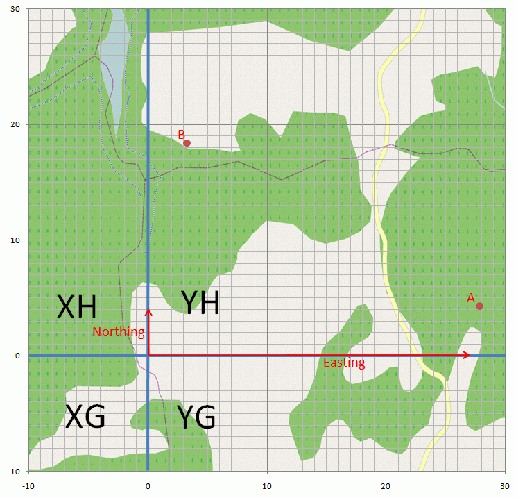
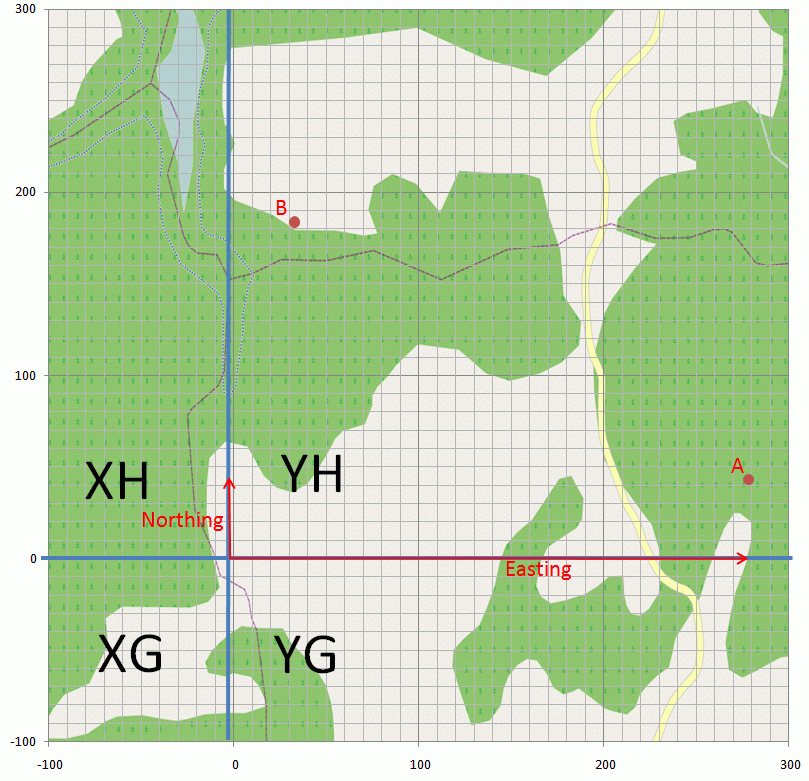
I got a lot of positive feedback when I posted this in another thread (thanks – appreciated!). The kind words made me feel obliged to improve upon it, so I decided to add some graphics, clean it up and make it a thread of its own in order to make it easier to find and understand. Background reading I’d like to begin by pointing you to Military Map Reading 201 by the NGA. It is well worth a quick read. Fifteen minutes, and it will all come clear to you. If it doesn't, I'll instruct over MSN if need be - that's how confident I am in you really getting it. :) In the beginning, there was UTM The world is divided into large grid zones. They're given a number from 1 to 60 based on their east-west position (longitude) and a character based on their north-south position (latitude). You can then give any coordinate as a combination of a grid zone and the distance east and north from the southwestern corner of that grid zone (it's really a bit more involved, but that's the general idea). 38T and two longish figures, for example. This is the UTM system. MGRS grid squares However, UTM is rather unwieldy to work with, especially if you are out in the field trying to call in arty support over the radio, or in an aircraft trying to communicate the position of a target or friendlies on the ground. To make it easier, the MGRS was introduced. Each grid zone is divided into a large number of 100.000 by 100.000 meter grid squares. These grid squares are given designators based on their north-south and east-west position within the grid zone, using one character for north-south and one character for east-west. AM, MM, DL etc. Now you can point out an arbitrary 100.000 by 100.000 meter square anywhere on the planet, using a designator such as 38T ME. Coordinates within the squares - eastings and northings From there, we only need to be able to designate a certain smaller square within that square, in order to point out targets. You do this just in the same way as you did within the grid zone using UTM, by measuring the distance east and then north of the southwestern corner of the grid square. The two distances describe the position within the square and are known as the easting and the northing. As the square is 100 km across, you need two figures per coordinate (east/north) to give 1 km precision (0-99 km east/north of SW corner). If 10 km precision is enough (unlikely ;)), you only need one figure. The first ten km east/north of the SW corner is then 0, the next ten 1 etc. For pointing out targets, you will generally need to get down to ten meter squares. As there are 100.000/10 ten-meter squares to each side of the 100.000 m two-character grid squares, you then need four digits (0-9999) for the easting, and another four for the northing. For one meter precision, you need five digits. Putting it all together A full MGRS coordinate consists of the grid zone, grid square and finally the easting and the northing written together as one long string of digits, with the easting first (XY, not YX). Frequently, the grid zone is omitted once it is assured that everyone else is using the same grid zone. 38T ME04586742 would mean a ten meter square (four digits for easting/northing respectively) within grid square ME in grid zone 38T. To find the position, you'd divide square ME into ten meter squares and find column 458 from the western side. Then you'd find row 6742 from the southern edge of square ME. In reality, there are supporting lines in the maps making finding these coordinates easy. You're really finding a point 4580 m to the east and 67420 meters to the north, and then you know the object for which the coordinate is given to be in the 10 by 10 m square to the NE of this point. Examples I've attached two map images. In both maps, the two fixed points A and B are plotted. Also notice how you have four different grid squares in the map images, each with a different two letter designator. In one picture the coordinates are given using two figures for easting and northing, respectively. Point A is in this case at grid YH2704 – easting 27, northing 04 in grid square YH. In the other picture, the coordinates are given using three figures for easting and northing. Point A is in this case at grid YH278043. It is still in exactly the same position as in the previous example, but the position is given with a higher degree of accuracy. Note how the easting is truncated instead of rounded, i e 278 becomes 27 rather than 28 when going to a lower precision. This is due to the position always being in the appropriately sized square NE of the designated point, as previously described. The coordinates of point B are left as an exercise for the reader. (Ignore the negative coordinates on the axes in the pictures. MGRS coordinates are never negative, I just couldn’t be arsed to edit them out after clipping the pictures from my drawing program of choice Excel . Yes, I’m a worthless artist.) Clear as mud? Didn't think so. Go read the PDF and look at the graphics. Told you it's worth it! DCS caveats (obsolete due to bug having been fixed) Visualization If you want to visualize the MGRS grid system in Google Earth, you can download a KML file which does this. Anecdotes "There were ten of us, living in a shoebox in the middle of the street..." If your head is spinning at this point, consider this: I fly and work using WGS84 (lat/lon). I initially learned one coordinate system in the army, only to later transition to MGRS which I still use for weekend warrior duty. Now, I also fly fire watch missions. When coordinating with the fire services on the ground, we use the first coordinate system I learned as they haven't switched to MGRS. Coincidentally, that coordinate system gives the northing before the easting, but calls the northing X and the easting Y. Now, try to get all that sorted out while circling above a fire in a very warm cockpit being jostled by turbulence and trying to find forest roads to guide the fire trucks in along using a radio with very poor reception... :pilotfly: Please let me know if you have any suggestions for clarifications or improvements, or if my Airman's Prayer ("Please don't let me screw this up!") didn't pay off. ;) Cheers, Fred

-
Allright. So we have 1) Two pictures of A-10s firing, with pilots in the cockpit, showing a head position similar to that in the simulator. 2) Picture of green-clad knees, showing... well... it's an A model? 3) Picture of a civilian in a stupid hat in the cockpit showing a head position which does not agree with what we see in the simulator. 4) A lot of statements which have been or can rather easily be contested. While the references and arguments are not going your way, it was a very smart move to accuse me of being in denial. I mean, with that thrown at me, what can I do but bow down to your supreme wit and knowledge? I do have a plausible explanation for what we're seeing, but now you're not hearing it... Neener neener! Well, to be honest, most of it has already been pretty well alluded to above. I think I'm done here for now. Buh-bye! :bye_2:
-
Assuming that the dimensions of the HUD are true-to-life, and assuming that the HUD symbology is sized according to specifications - which are quite reasonable assumptions, considering the access ED obviously have to the docs - the design eye point for HUD use is just about right where it is in the sim right now. For that, the proof is in the pudding and we can all see it. We should set up an object of a known size at a known distance and compare the size of said object to the HUD size of the depressible pipper. Then we can assess the size of the HUD symbology, as we know the mil diameter of the pipper. What is an "eyebox"? You don't think it is realistic. You're fully entitled to thinking so, and to try to convince others. Convince me it's wrong and I will not hesitate to change my mind. I don't mind at all, do go ahead! A scientific/technical discussion where you use your references and arguments to show that those of us who think it is right are in error will surely help your case. I'm happy to help! :thumbup:
-
Last I heard, the "undefeated in BFM" was only during rather strict restrictions on the engagement as well. Basic performance - top performer, as rumored and expected - but as soon as you threw in things like having to spend time on keeping tabs on multiple opponents etc, surprising things happened. The pilot was no longer able to spend the cognitive ability required to make the aircraft perform and thus lost against technically inferior aircraft, even in BFM.
-
Aaaagh, all the configuring is getting to me! It is desired to be able to preconfigure it all through a better interface and pop it on your virtual datastick as you click yourself out to the aircraft! :D I know it says "translator" under your nick, but you're a smart guy. Go program that feature now! I won't tell anyone you did it. ;) Cheers, Fred
-
Neat. Got a pic of the base of it as well? Me, I've got a 5.56 and a sign saying "Scale 1:5.4". ;)
-
Sorry guys. Rest assured that it is not at all complicated. The linked document is well worth a quick read. Fifteen minutes, and it will all come clear to you. If it doesn't, I'll instruct over MSN if need be - that's how confident I am in you really getting it. :) The world is divided into large grid zones. They're given a number from 1 to 60 based on their east-west position (longitude) and a character based on their north-south position (latitude). You can then give any coordinate as a combination of a grid zone and the distance east and north from the southwestern corner of that grid zone (it's really a bit more involved, but that's the general idea). 38T and two longish figures, for example. This is the UTM system. However, UTM is rather unwieldy to work with, especially if you are out in the field trying to call in arty support over the radio, or in an aircraft trying to communicate the position of a target or friendlies on the ground. To make it easier, the MGRS was introduced. Each grid zone is divided into a large number of 100.000 by 100.000 meter grid squares. These grid squares are given designators based on their north-south and east-west position within the grid zone, using one character for north-south and one character for east-west. AM, MM, DL etc. Now you can point out an arbitrary 100.000 by 100.000 meter square anywhere on the planet, using a designator such as 38T ME. From there, we just need to be able to designate a certain smaller square within that square, in order to point out targets. You do this just in the same way as you did within the grid zone using UTM, by measuring the distance east and then north of the southwestern corner of the grid square. As the square is 100 km across, you need two figures per coordinate (east/north) to give 1 km precision (0-99 km east/north of SW corner). If 10 km precision is enough (unlikely ;)), you only need one figure. The first ten km east/north of the SW corner is then 0, the next ten 1 etc. For pointing out targets, you will generally need to get down to ten meter squares. As there are 100.000/10 ten-meter squares to each side of the 100.000 m two-character grid squares, you then need four digits (0-9999) for the easting, and another four for the northing. For one meter precision, you need five digits. A full MGRS coordinate consists of the grid zone, grid square and finally the easting and the northing written together as one long string of digits. Frequently, the grid zone is omitted once it is assured that everyone else is using the same grid zone. 38T ME04586742 would mean a ten meter square (four digits for easting/northing respectively) within grid square ME in grid zone 38T. To find the position, you'd divide square ME into ten meter squares and find column 458 from the western side. Then you'd find row 6742 from the southern edge of square ME. In reality, there are supporting lines in the maps making finding these coordinates easy. You're really finding a point 4580 m to the east and 67420 meters to the north, and then you know the object for which the coordinate is given to be in the 10 by 10 m square to the NE of this point. Clear as mud? Didn't think so. Go read the PDF and look at the graphics. Told you it's worth it. :) Edit: Cleaned this up a bit and added a few explanatory graphics over here.
-
Software development done right. :)
-
Not that I've heard of, but I haven't really followed the discussion either. Haven't verified the bug myself, but seen others report it.
-
See this post for an explanation (without the graphics). UTM and MGRS are not the same. MGRS is an overlay on UTM, making the coordinate format more manageable by dividing the large UTM grid zones into smaller, alphanumerically designated 100,000 m grid squares, thereby significally cutting down on the number of digits needed for a position reference over the radio and the potential for misunderstanding. You need to make sure that the double character grid square (e g WC, MM, DS) and grid zone designator (number plus character, e g 38T), are correct as well as the coordinates. I think JTAC typically omits the grid zone, just assuming everyone to be on the same page so to speak. Typically, you pre-brief which grid zone you're in (at least where I'm at) so it can be safely omitted unless you're operating right on the border between two grid zones and have different charts. But as Napoleon said, anything important in a war will happen between two chart sheets. Remember to truncate rather than round. Eg let us say that the MGRS for the dot following "Gusconade R" in the graphic is at approximately MGRS XC086397 (which is not quite true, as far as I can see, but it needs to be for the example to work). With lower, more realistic precision, it'd be XC0839, rather than XC0940. A grid point always means the referenced object is in the grid square east/north of the point. In the graphic, the point used could be described as, with decreasing precision, WC8081751205 WC80815020 WC808512 WC8051 WC85 The 0 in 067 can NOT be dropped. No way, never. DCS drops leading zeroes on the eastings. This is a bug, which always gives incorrect coordinates and which can give unusable coordinates if there are two leading zeroes. To use coordinates with leading zeroes dropped in the CDU, you need to reinsert the missing zero. Odd number of digits -> Assume missing leading zero. Double leading zeroes missing? You have no way of knowing something is amiss and you're basically screwed. Regardless of the number of digits, it's still a grid square. The number of digits determines the size of the grid square indicated, or the uncertainty in the position reference.
-
I did, and came to entirely different conclusions than you did. If your eyes are not below the top of the HUD, you're going to have some serious problems with some of the symbology on the HUD. How to interpret the available imagery seems to leave some room for opinion. That's OK. I have the greatest respect for the fact that opinions can differ. I have the right to my opinion, and if someone disagrees then he or she has the right to be wrong. :music_whistling: While it does feel as if you are squashed up against the dash, I don't have a problem with it while flying. I can imagine that the HUD design eye point is where your head ends up when you hunch up a bit, which is natural when attacking. That would mean less than optimal HUD usage when leaning back and relaxing, which is quite OK as you'll be looking outside and using other instruments then. I've put longitudinal head position on a slider to give me the option, but find I almost never use it in flight. (BTW, I hate to rain on your parade, but careful image analysis reveals that the reference pictures you posted are with approximately 94% certainty not, in fact, real pictures but rather artist's impressions/screenshots from an advanced video game) Edit:
-
The HUD is specified in terms of the angles the symbology covers. No way around it. It is x mils wide by y mils high, and that's it. The pilots nominal eye position is also very carefully specified in all modern aircraft designs. Given the above, and the known size of the HUD combiner, there's also only really one position in which the HUD symbology will all be visible and fill the combiner. ED obviously have access to these specifications. I think these things are about as negotiable and open to interpretation as the size of the vertical stabilizers.