GeorgeVB
-
Posts
67 -
Joined
-
Last visited
1 Follower

-
I'd like to see the NASA livery. Apparently, some kind of special radar is installed on such an aircraft.
-
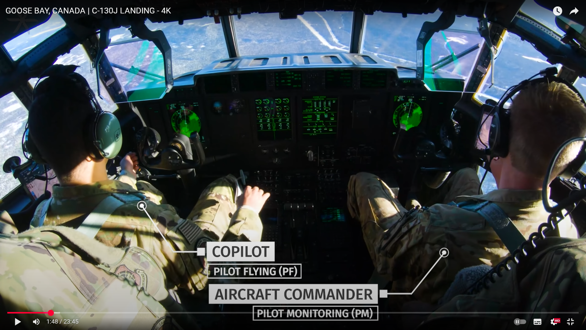
Красивые видео о полётах на С-30J, но почему второй пилот слева, это только на этот полёт, или действительно командирское место на этом самолёте справа? https://www.youtube.com/@ReachAviation

-
Замечательный мод, разработчики - молодцы. Баги были и будут, это не проблема, если их изучают и устраняют. Переключение каналов АРК - по часовой и против часовой перепутано.
-
Так оно, но какое-то общее представление хотелось бы составить. Как я понимаю, C-130J турбовинтовой, есть ли у него режим взлета ТО-1 и ТО-2, или какие-то аналоги?
-
nullЧто я не нашел - оптимальные скорости набора и снижения. Интересно, как дальность маршрута соотносится с желаемой высотой эшелона, это специфическое соотношение для каждого типа самолётов, или что-то обобщенное? 478 страниц на английском. Я пока и четверти не осилил. Вообще не знаю, какие параметры набора и снижения используются на С-130, и тем более не знаю, что об этих параметрах думают разработчики. Текст мануала - теория, как оно на практике - не представляю
-
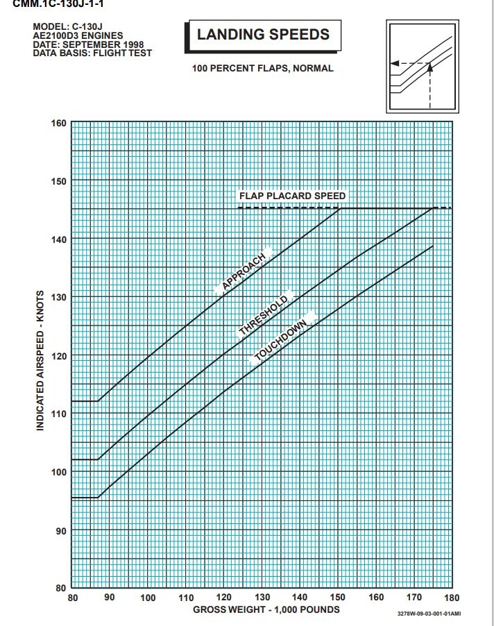
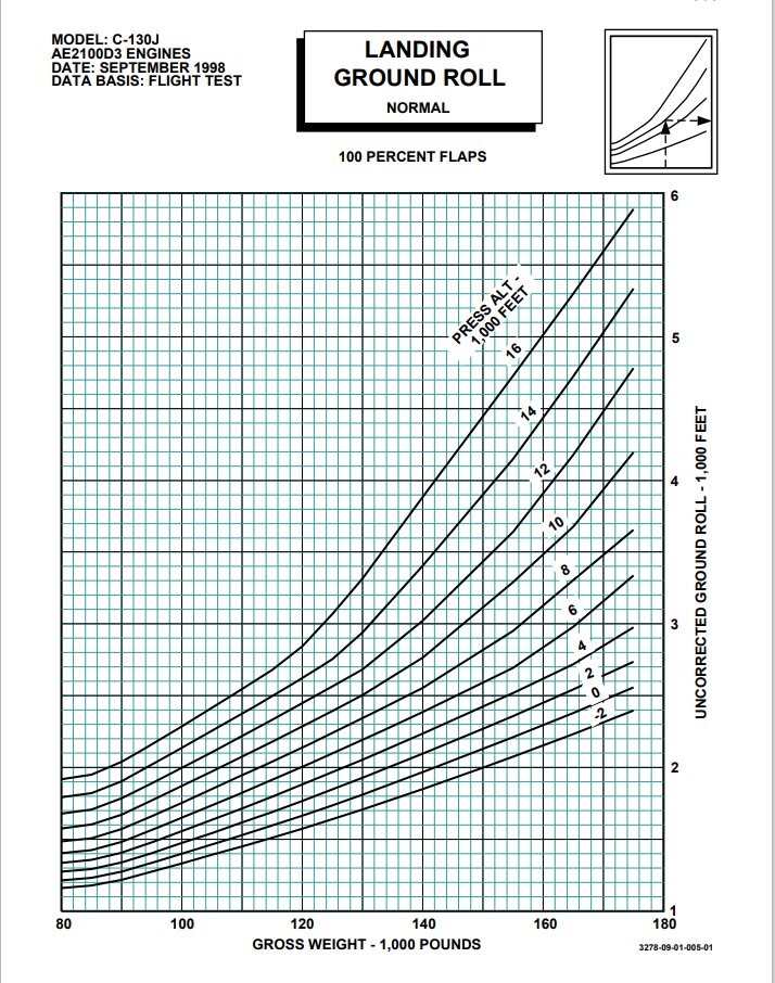
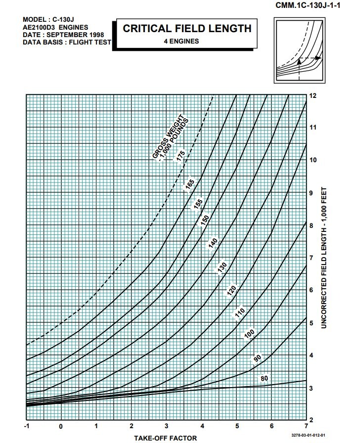
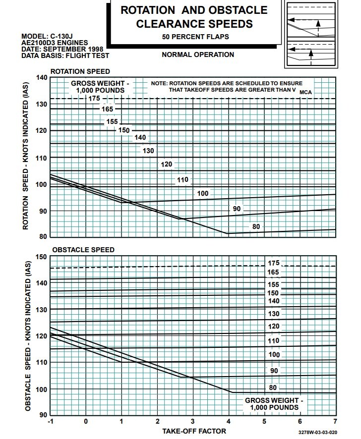
Есть и такое, nullnull Только я не могу понять, OBSTACLE SPEED - это аналог VA, безопасной скорости манёвра, или тут какая-то другая идея? Пытаюсь разобраться в документации, больше вопросов, чем понятного. TAKE-OFF FACTOR я считаю за единицу, есть таблица для его расчета, но пока не важно.
-
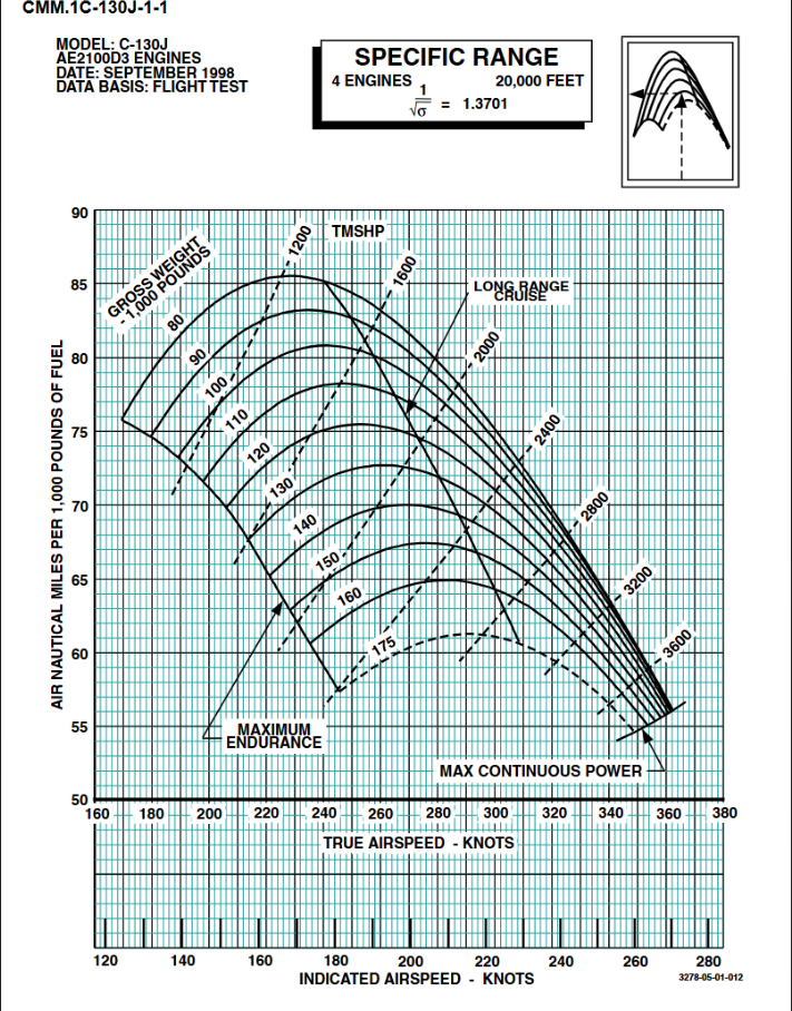
Правильно ли я понимаю из этой таблички, что на высоте 20 000 футов C-130J весом 100 000 фунтов, удерживая IAS = 178 KNOTS пролетит на тысяче фунтов топлива 81 морскую милю, и это будет самым экономичным режимом полёта на такой высоте? https://www.docdroid.com/pDQh0cn/italian-c-130j-performance-manual-pdf#page=196
-
Lockheed Martin has launched an updated civilian version of its C-130J Super Hercules transport, and expects to receive its first order from a customer later this year. https://www.flightglobal.com/lockheed-launches-civilian-version-of-c-130j/112319.article I would like to see a civilian version of the aircraft, or at least a livery.
-
После очередного патча в X-Plane доработали УВД, игровой диспетчер выдаёт STAR, можно попросить другие варианты захода и другую полосу, что здорово. Но есть и проблемы, работа диспетчера основана на скриптах и если какое-то условие не исполняется, то увы. Убедить диспетчера в возможности развернуться на полосе у меня не получилось. С-130 заказал, надеюсь, что будет и гражданская версия, без RWR и тепловых ловушек
-
As far as I understand, the video shows the cockpit of the C130J aircraft (or is it an upgraded C-130H?). Argentina use this aircraft for flights to Antarctica. I would like to see this livery But I have not found an image of this plane on the Internet...
-
 GeorgeVB changed their profile photo
 -
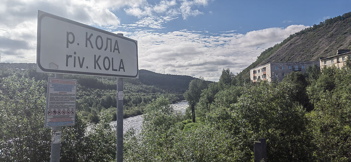
The Kola River in the city of Kola on the Kola Peninsula
-
Надеюсь, что в руководстве к МиГ-29 будет подробно расписан, например, полёт по кругу, со скоростями, работой механизации, расчётом расхода топлива и т.д. Хотелось бы видеть расчёты оптимальных скоростей и высот для составления полёта по маршруту для разных конфигураций вооружения. А не просто перечисление характеристик самолёта, и лети как хочешь. Может быть, у кого-то в сообществе есть реальные планы полётов, или кто-то может их составить и описать, почему они именно такие?
-
По этому предпочёл бы Ирак, но надо несколько авиабаз Ирана рядом с границей.
-
METAR, в принципе, можно подгружать, а можно и подкорректировать существующий в сторону улучшения/ухудшения погодных условий, силы и направления ветра и воспроизвести, пусть и с упрощениями. С НГ, кстати
-
I agree with you, that's probably the reasons