GeorgeVB
-
Posts
67 -
Joined
-
Last visited
Content Type
Profiles
Forums
Events
Everything posted by GeorgeVB
-
I'd like to see the NASA livery. Apparently, some kind of special radar is installed on such an aircraft.
-
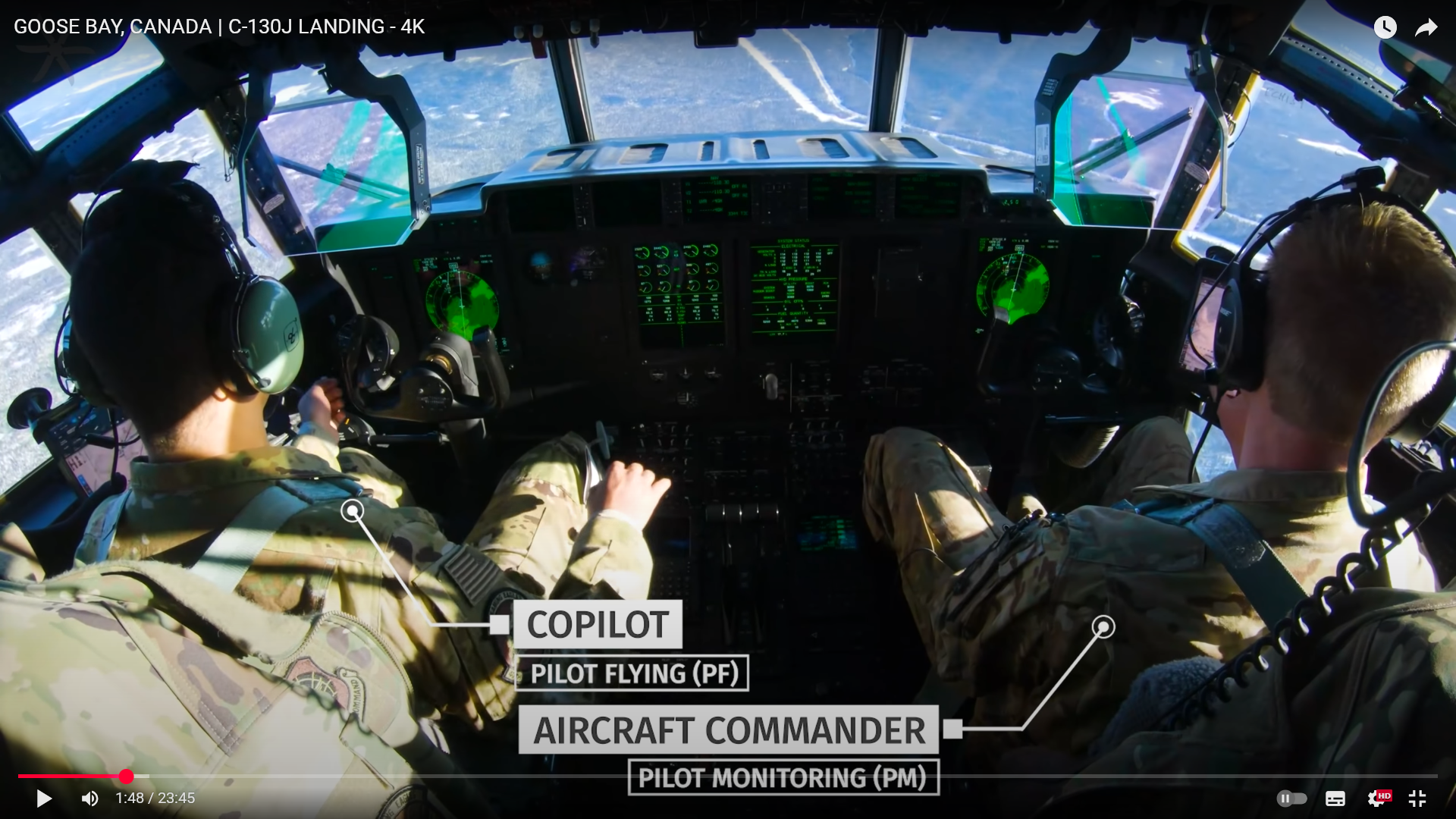
Красивые видео о полётах на С-30J, но почему второй пилот слева, это только на этот полёт, или действительно командирское место на этом самолёте справа? https://www.youtube.com/@ReachAviation

-
Замечательный мод, разработчики - молодцы. Баги были и будут, это не проблема, если их изучают и устраняют. Переключение каналов АРК - по часовой и против часовой перепутано.
-
Так оно, но какое-то общее представление хотелось бы составить. Как я понимаю, C-130J турбовинтовой, есть ли у него режим взлета ТО-1 и ТО-2, или какие-то аналоги?
-
nullЧто я не нашел - оптимальные скорости набора и снижения. Интересно, как дальность маршрута соотносится с желаемой высотой эшелона, это специфическое соотношение для каждого типа самолётов, или что-то обобщенное? 478 страниц на английском. Я пока и четверти не осилил. Вообще не знаю, какие параметры набора и снижения используются на С-130, и тем более не знаю, что об этих параметрах думают разработчики. Текст мануала - теория, как оно на практике - не представляю
-
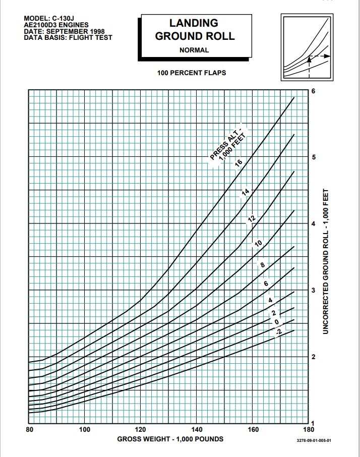
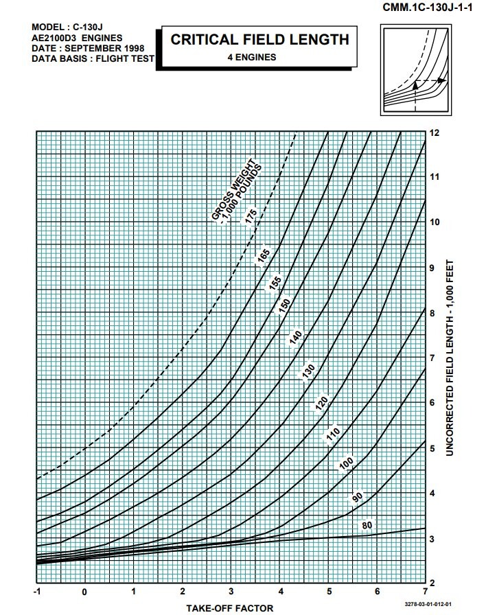
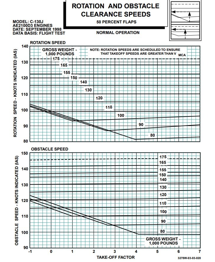
Есть и такое, nullnull Только я не могу понять, OBSTACLE SPEED - это аналог VA, безопасной скорости манёвра, или тут какая-то другая идея? Пытаюсь разобраться в документации, больше вопросов, чем понятного. TAKE-OFF FACTOR я считаю за единицу, есть таблица для его расчета, но пока не важно.
-
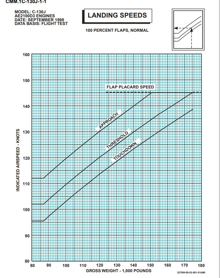
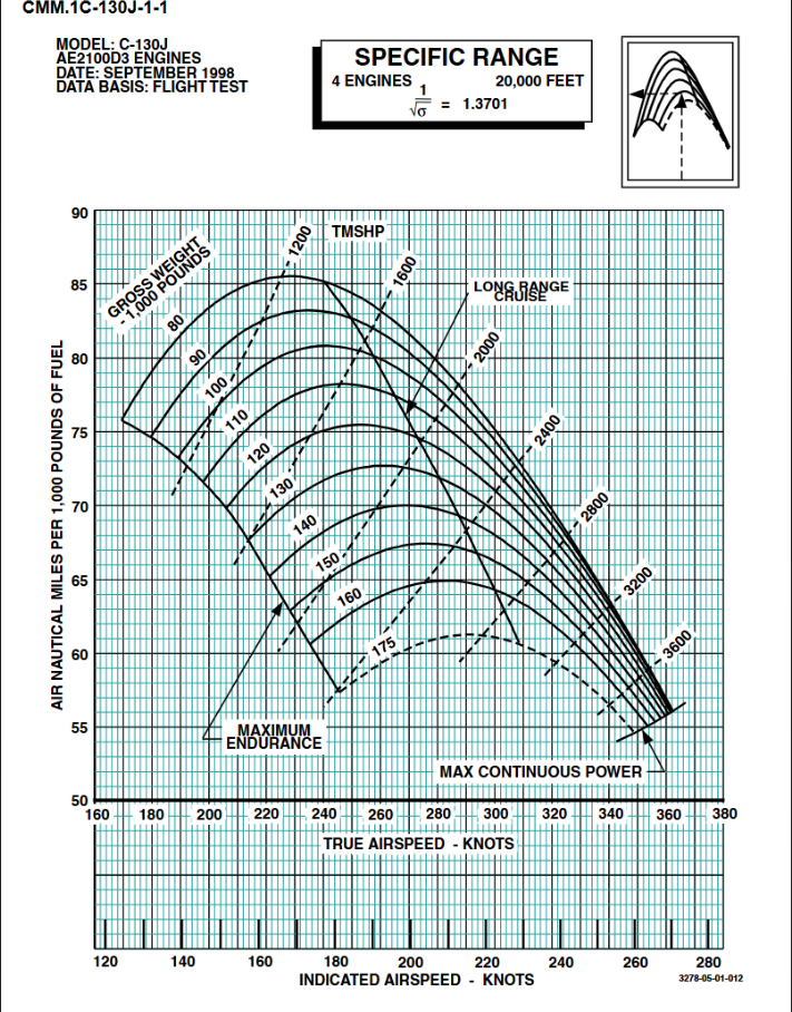
Правильно ли я понимаю из этой таблички, что на высоте 20 000 футов C-130J весом 100 000 фунтов, удерживая IAS = 178 KNOTS пролетит на тысяче фунтов топлива 81 морскую милю, и это будет самым экономичным режимом полёта на такой высоте? https://www.docdroid.com/pDQh0cn/italian-c-130j-performance-manual-pdf#page=196
-
Lockheed Martin has launched an updated civilian version of its C-130J Super Hercules transport, and expects to receive its first order from a customer later this year. https://www.flightglobal.com/lockheed-launches-civilian-version-of-c-130j/112319.article I would like to see a civilian version of the aircraft, or at least a livery.
-
После очередного патча в X-Plane доработали УВД, игровой диспетчер выдаёт STAR, можно попросить другие варианты захода и другую полосу, что здорово. Но есть и проблемы, работа диспетчера основана на скриптах и если какое-то условие не исполняется, то увы. Убедить диспетчера в возможности развернуться на полосе у меня не получилось. С-130 заказал, надеюсь, что будет и гражданская версия, без RWR и тепловых ловушек
-
As far as I understand, the video shows the cockpit of the C130J aircraft (or is it an upgraded C-130H?). Argentina use this aircraft for flights to Antarctica. I would like to see this livery But I have not found an image of this plane on the Internet...
-
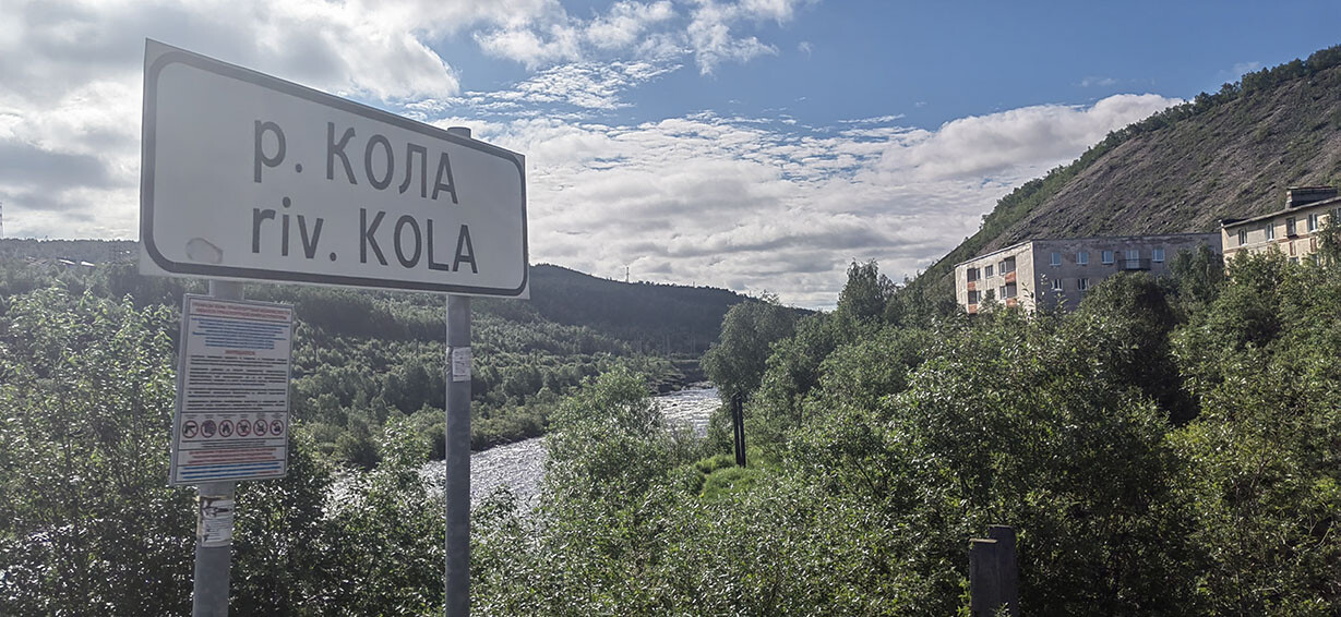
The Kola River in the city of Kola on the Kola Peninsula
-
Надеюсь, что в руководстве к МиГ-29 будет подробно расписан, например, полёт по кругу, со скоростями, работой механизации, расчётом расхода топлива и т.д. Хотелось бы видеть расчёты оптимальных скоростей и высот для составления полёта по маршруту для разных конфигураций вооружения. А не просто перечисление характеристик самолёта, и лети как хочешь. Может быть, у кого-то в сообществе есть реальные планы полётов, или кто-то может их составить и описать, почему они именно такие?
-
По этому предпочёл бы Ирак, но надо несколько авиабаз Ирана рядом с границей.
-
METAR, в принципе, можно подгружать, а можно и подкорректировать существующий в сторону улучшения/ухудшения погодных условий, силы и направления ветра и воспроизвести, пусть и с упрощениями. С НГ, кстати
-
I agree with you, that's probably the reasons
-
A military helicopter must operate in an unfamiliar territory, and the possibility of instrumental flight is present in the manual. Even familiar territory is dangerous in low visibility conditions. Searching for an unknown radio source is quite suitable for Reconnaissance operations, and SOS rescue is a common duty. Flight types (Base task list) are specified in the OH-58A Manual_2013 manual.pdf OH-58A Manual_2013.pdf, pp 16-18. (Sorry, this Manual for OH-58D!) The idea to remove TACAN/VOR/ADF systems has other reasons
-
What if the INS and GPS readings contradict when flying over mountains in dense clouds? How can I find a ship at sea if it has turned on the beacon but does not transmit coordinates? I would like to know the reasons why ADF/VOR navigation is not used. Civil aviation uses all means of navigation
-
https://www.airwar.ru/other/manuals/[aviation] - [manuals] - TM 1-1520-248-10 - Technical manual Operator`s manual for army OH-58D.pdf p 160 I hope that the developers will add TACAN someday...
-
OH-58A/C used ADF and VOR/LOC, https://www.avialogs.com/aircraft-b/bell/item/55450-tm-55-1520-228-10-operator-s-manual-army-model-oh-58-a-c-helicopter pp 144, 148 For what reason were this systems not installed in the OH-58D?
-
Can a helicopter use these systems for navigation?
-
Есть ли у вертолёта навигация по TACAN/VOR/ADF, или всё ориентирование завязано на GPS? В мануале за 1989 год ADF есть, в мануале за 2013 год ADF не упоминается.
-
База Шираз сейчас есть на карте Залива. Меня интересует появление иранских баз на карте Ирака
-
Шираз есть и на нынешней карте, но он на краю, от него лететь далеко. На северо-западе Ирана баз с десяток, они ближе и они использовались во время Ирано-Иракского конфликта
-
Планируются ли для карты аэродромы Ирана?
-
Thanks!