Kingtiger45
-
Posts
4 -
Joined
-
Last visited
Content Type
Profiles
Forums
Events
Everything posted by Kingtiger45
-

Campaign for DCS OH-58D: "Through the desert dust"
Kingtiger45 replied to YoYo's topic in DCS: OH-58 Kiowa
Im on mission 4 and having struggles with getting my AI wingman (1-2 Ethan) to take off and join me. Is there something special I need to do to get them to take off? as it is now they start spooling up and after a while they shut down. /KT -
Campaign for DCS OH-58D: "Through the desert dust"
Kingtiger45 replied to YoYo's topic in DCS: OH-58 Kiowa
I'm looking forward to playing this indeed. We lacks good campaigns for the kiowa.- 116 replies
-
- 2
-

-
- single player
- campain
- (and 1 more)
-
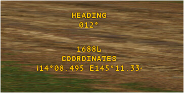
Since we now have Marianas map where the lat/long coordinates easting is 3 numbers the coordinates has been clipping out to give a incomplete coordinate. See attach picture for example. MGRS and X/Y still work as before, its only the Lat/long coordinates that has become to long to be displayed correctly. /KT

-
When I use the JTAC function in combined arms and use smoke marking through B key and put down coloured smoke it eventually disappears. But for the aircraft supporting me the smoke do not disappear. I had one instance where I had marked a target with smoke 1.5hours before another player checked in for CAS and he could see that smoke still while it was gone for me as JTAC. Normal smoke like vehicle destroyed smoke that vanish for me vanish for other players as well, so the problem is the marking smoke who doesn't go away for other players. This is happening on dedicated server with open beta with latest update. /KT