zerO_crash
-
Posts
1663 -
Joined
-
Last visited
-
Days Won
1
Content Type
Profiles
Forums
Events
Everything posted by zerO_crash
-
 To put it straight: If you have FFB pedals (like me - though still waiting for ED to implement separate FFB output channels), you can simulate the operation of the Mi-24P/Ka-50 AP). Wherever you put the microswitch from the pedals, as long as you use it correct (I have mine on the pedal-brakes), the AP will not interefere when you have control. Also, should you let go of the microswitches, the pedals will always move according to how the AP offsets them (provided heading-hold AP-channel is on). If you don't have FFB pedals, you can forget the whole shebang. There is a reason I requested from ED the special-setting which let's you turn off "AP pedal offset". This is not a matter of preference, this is a matter of logic. If you fly with with such a setup, even with a microswitch, it doesn't matter. As soon as AP starts trimming your pedals (microswitch depressed), your non-FFB pedals will be offset to the virtual pedals. The problem that you can imagine then, is that if AP trims them left pedal-heavy (wind, turn with slip, etc...), and you chose to come to hover, it will result in the following - you will max out your right pedal to counter torque of main rotor, whilst virtual offset is (in the worst case) equal to neutral pedals. That means, you are spinning and crashing baby. As you should understand, this is not a matter of perspective. Allowing the AP to trim anything that doesn't have FFB, is actually a catastrophy, as it limits your movement. In the same way that pedals will get trimmed by AP when you let go of the microswitches (on the pedals), the AP will move the virtual position of your cyclic when in auto-hover AP-mode. You have to be aware that the AP can offset your virtual position (the important one), without you realizing it. This isn't a matter of preference, it's a recommendation based on what works and what doesn't. If you seek an experience alas that of flying a rocket with pedals and a steering wheel, have fun. You'll notice soon enough that what is being shared here, is a culmination of experience and practical application.
 -
Can I share server admin permission?
zerO_crash replied to Wile E.'s topic in Multiplayer Server Administration
Teamviewer (or any screen sharing software) will also work. It all depends on how trustworthy those "others" are. In an older clan that I was in, we had the setup with Teamviewer, albeit with the confidence that it wouldn't be exploited. -
Красива! И это, баг или фича?
-
Attaching a short track of using the speed-hold AP in Caucasus. To stress-test it, I created an empty mission with ridiculous winds/storm (at the limit of what you are allowed to take off with in just about any helicopter, except Kamovs.). One would never use any hold modes, other than heading, in this weather: Wind: 8000m - 45m/s 2000m - 40m/s 500m - 32m/s 10m - 15m/s Turbulence: 4.5m (45*0.1m) Over a course of multiple runs for exhaustive testing, the highest deviation I had was 20km/h, but that only for an isntant, quickly falling back to within 10km/h. This isn't visible in the track, btw. As for the track, I engaged the speed-hold at approximately 197km/h, and you can see how well it holds it with this weather. It's truly a fantastic AP-suite. Mi-8MTV2 Speed-hold AP.trk TEST1.miz
-
Patience, while we cannot say for sure, I imagine that cutting off Steam users is the least lucrative option. In any case, a transition period would have to follow with ED voicing their intentions. They haven't done so, so don't worry. Obviously, F-4E has had delays of different nature, likely the reason why they held off.
-
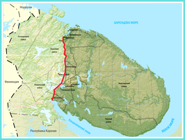
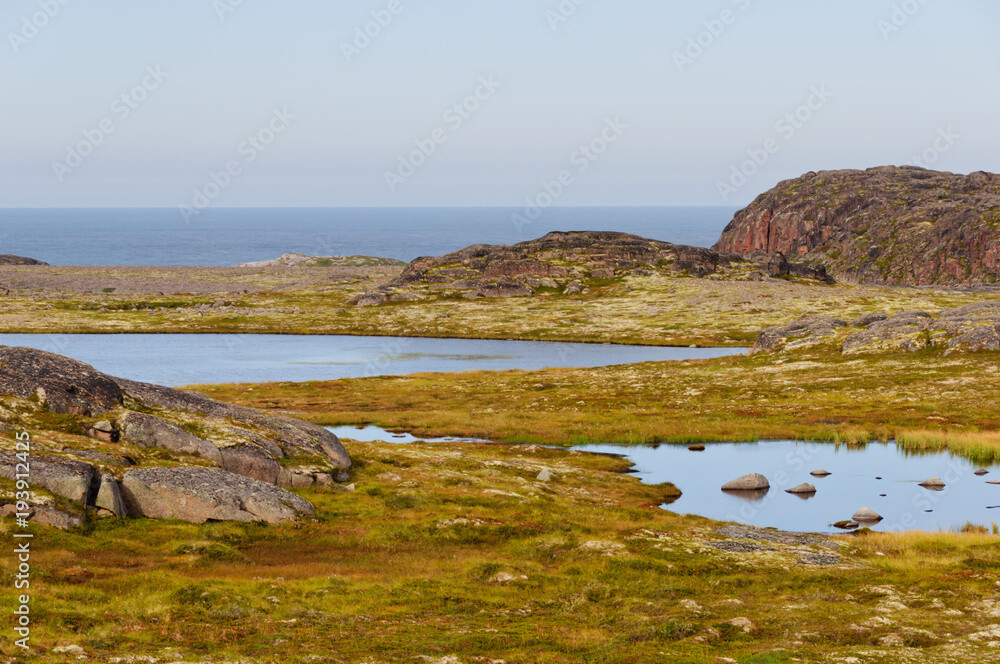
Forget the kid, obviously the maturity progress is still ongoing. In any case; here is a map of Kola, showing just the extent of the barren plains known as tundra. Below, are photos showing what it looks like. While Orbx will need to work on the color of the ground textures (especially in fall/spring), as well as introducing rocks and the likes, it will still remain for a much part barren: (Those cliffs are along the northern coast - Musta Tunturi region.)

-
Likely a hold-off until F-4E in two weeks. It's logical to release a cumulative update, given esp. recent bugs and their priority.
-
Depending on winds, I can see the AP holding the speed within 10-15km/h of my selected speed (a short spike of 15km/h deviation was in heavy winds and turbulence, otherwise, a maximum was 10km/h, before the AP stabilized back on speed). That's to say, in the worst case, I saw the speed deviate up to 15km/h, before quickly going back. Generally, when you engage it, the speed-hold will take a couple of seconds to adjust. That is also when you will experience those deviations, otherwise in really heavy wind/turbulence. The altitude changed by 5-6m from my preset (it was oscillating), but normalized over time (not that it should be held, it was simply to give a reference of AP stability).
-
Да, но это не так сложно, как продвинутая модель повреждений (модули Великой Отечественной войны). Что спросил Кros. Это важная часть дизайна вертолета - выживаемость, избыточность. Я бы заплатил 100/200/+++ долларов за ЧА со всеми деталями внутри. Я уже упоминал вихри - в жарком/высокогорном климате (Афганистан/Кавказ) вес важен. RLE объясняет гидравлику, показывает схему, показывает показатели, но бесполезен при симуляции как единая система... Я восхищаюсь работой ED, но вот так. Не хочу превращать форум в список желаний... Также - 9 мая. Поздравляю всех участников форума! С праздником Победы!
-
Есть ли планы на новый Камов? Ка-25/27/29? С Кольской картой и новым Кузнецовым - это было бы хорошим дополнением.
-
Military and Aviation News Thread (NO DISCUSSION)
zerO_crash replied to topol-m's topic in Military and Aviation
Aviation is beautiful! -
Вопрос о ПВИ-800 (возможно, ошибка). В ЧА3, нажатие/отпускание "ППМ" вызывает новый курс (см. ИЛС). Это правильно? ПВИ-800.mp4 В ЧА1/2 это не было так. РЛЭ недостаточно подробен. Ну eсли правильно, я понимаю почему так. Тем не менее, хотел бы подтвердить. Спасибо!
-
Я понимаю. Почему такая простота в моделировании? Я думал, что ЧА3 должен был решить? Я сформулировал это плохо. Я имел в виду упрощенное геометрическое нацеливание. Мне припоминается, что двигатели Ми-8МТВ2 разрушались (та самая причина).
-
Нужно быть конкретным. Вероятная проблема - отсутствие расширенной модели повреждений. Пока не реализована для вертолетов. Другая причина может быть в точности искусственного интеллекта. Они стреляют в определенные компоненты и точно.
-
One correction - 949AM is a modernized "Oscar II class". That's to differ from "Oscar II" - 949A (same name, pre-modernization, original) and "Oscar I" which was 949 (only two built - test subjects). Both 949A and 949AM are relevant (meaning one of the two could be made).
-
Well, we don't need all of those, in a sense, I'm already happy with Alphas and Deltas. Novembers have a pretty recognizable, good old Soviet, sail. Gives the map some '70/'80 touch. But yeah, this would be low priority, no doubt. I heard about the Thresher, "Jive Turkey" had a good presentation of it (YT). Didn't know it was in James Bond though, nice! Yeah, it's mostly combat, but then different types of patrol/familiarization/training mission do take place. That goes for all aircraft alike. One might/might not see it. There are overall more missions favouring medium-/low- altitude operations, than high. Consider land/sea operations. If you count in Combinef Arms, it definitely counts. It's surprising how many people solely run CA, with less interest in aviation. Agan, low priority for sure, but 1 - 3 more sub types make sense in a place like Kola. True story, most of the subsidies were commited around '95 - '05, around the collapse of U.S.S.R. US and Japan (Norway and EU - for shorter time) provided funding for dismantlig mainly nuclear submarines. Reason being that they didn't want U.S.S.R./Russia to dump low-level radioactive wastes (mostly reactor coolant - primary loop) into the sea, which sadly, was a common practice back in the day. Btw. everyone did behave carelessly with radioactive waste back then, consider Camp Century in Greenland, or dumping low-level (even high) radioactive waste. Again, people back then were cool: RPReplay_Final1715181693.mp4 If one knows what this is, what these guys are handling... yeah. (All died pre-maturely). Otherwise the first formalized concern regarding dumping of various "containers" in oceans: https://www.armscontrol.org/act/1999-07/dismantling-russias-nuclear-subs https://www.gao.gov/assets/emd-82-9.pdf https://youtu.be/EBeyA010HIg?si=OSoTo0-gr_u23gAF
-
I looked at it the first day. The models seem incomplete to me, with those hatches being exposed and the submarine reflecting light like it does (mesh with no texture on). It looks like a rough model right now. Interesting enough, the Deltas which are in the elevated dry docks, don't have these issues. Both models are Delta IV as far as I know. For Orbx, if it ain't too much to ask for. Some Oscar IIs are mandatory for this region. Also, Dmitry Donskoy (only Typhoon remaining operational until February 6th, 2023) would be a treat as well. While I expect it for later (lower priority), older Deltas, Sierras, Novembers, Victors, etc... would be perfect for rusting attractions. It would add this unique footprint to the map as well. EDIT: Looking at the famous Nezamentnaya Cove (NW of Polyarnyy), it's been cleaned out already in 2017. There are a few subs here and there, but it's not what ir used to be...
-
It's a delicacy thing. If you mention another sim, but that, in order to make a very specific point, no one will "punish you". If you, however, deliberately focus on trying to make comparisons, esp. without any greater relevance to DCS, then VACation it is. The mods are good people. Don't worry.
-
A look at real IHADS and IHADS + PNVS: IHADSS.mp4 IHADSS - PNVS.mp4
-
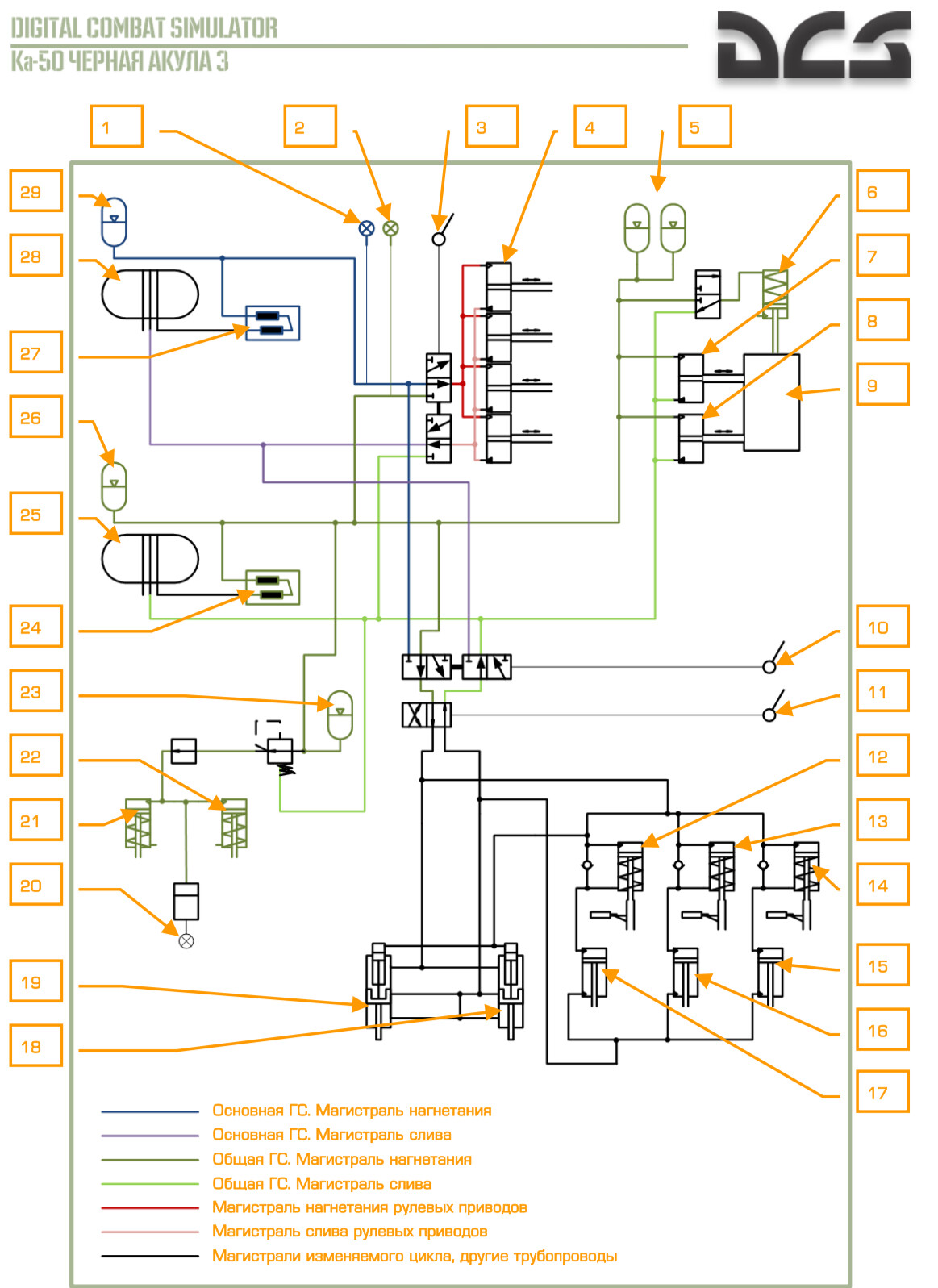
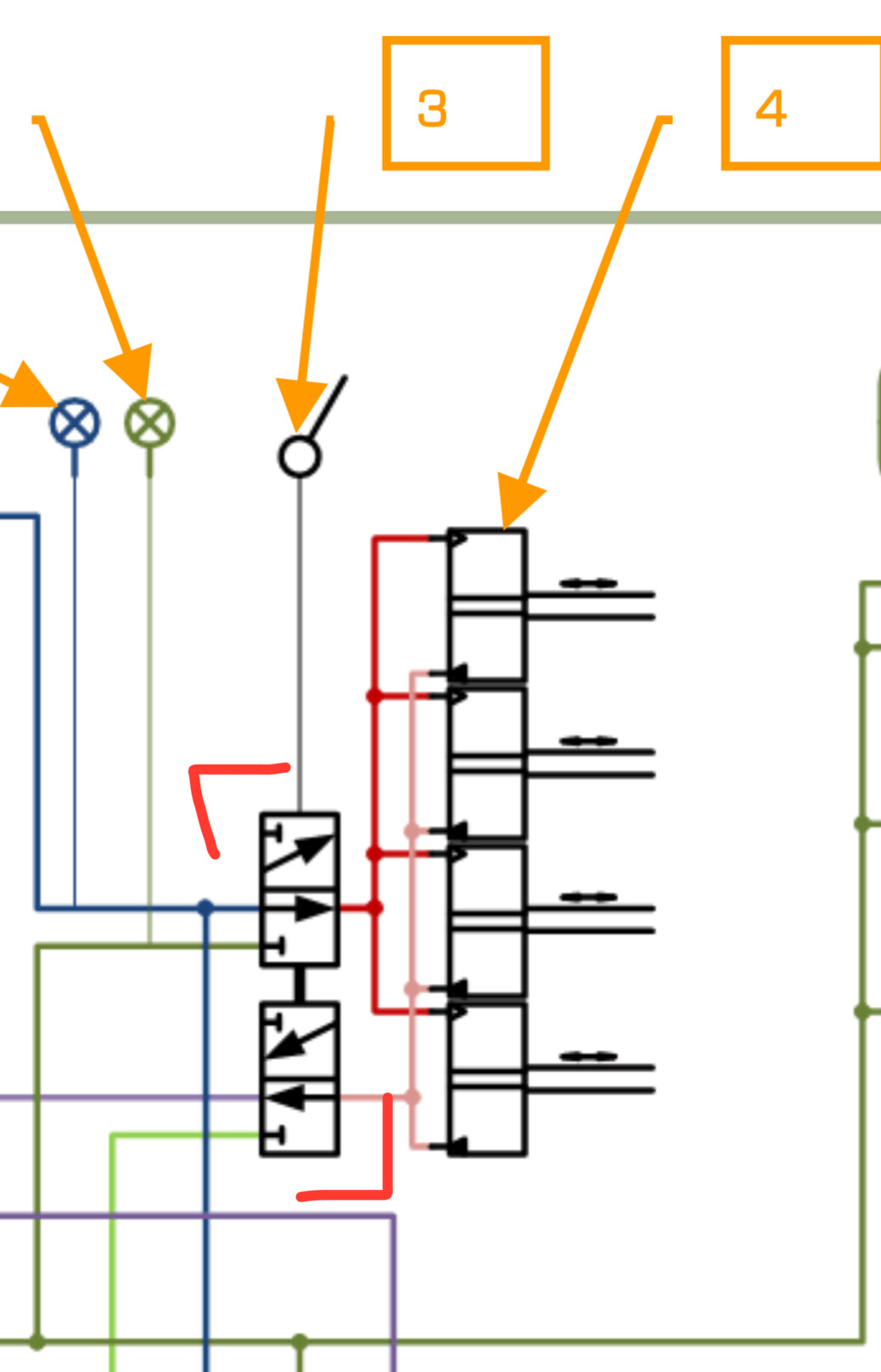
Я написал вторичную гидравлику, потому что она может заменить основную гидравлику в определенных функциях (управление вертолетом). Посмотрите схему гидравлики ниже: Переключатель #3 перемещается между источниками гидравлики для управления вертолетом #4 по тангажу/крену/рыскание/Рычаг "шаг-газ". Переключатель #3 можно перемещать двумя способами: 1) Автоматически, как вы упомянули. 2) Путем отключения основной гидравлики с помощью переключателя. Взгляните ниже: Системы независимы. Если у обеих есть утечки, обе повреждены. Также возможно, что повреждены линии управления. Вы можете проверить с помощью манометров. Если одна протекает, а затем другая, это линии управления. Если обе протекают одновременно, обе гидравлики повреждены.
-
Правильное поведение. Система теряет мощность для удержания позиций. Она переходит в нейтральное положение. Переключите вторичную гидравлическую систему.
-
Хорошо, братан! Murmansk is beautiful! It also shows what I've been mentioning. Mostly, it's visually stunning (this with civilian traffic in VR is great). Occasionally you come across rough ground/cut terrain, like you did some three minutes into the video. Overall, it's a good starting point!
-
In light of the recent release of the Kola map, I'd like to make a request for overall more focus on naval operations. I'm asking for the following: - More naval units, both civilian and military. Everything from submarines, to tourist cruise ships. While on-land, the ambient life can be adjusted with "civilian traffic"-slider. On the sea, however, in order to make any believable ambience, one has to individually place out units. That's not really a problem to do, but more variety would be appreciated. That is, both in objects as well as liveries. Possibly make a standardized scheme for naval routes (between ports) which would be connected to the "civilian traffic"-setting. Model ambient activity on ocean, as you do on land. (To expand here, a separate such traffic template should be created for air activity as well.) - More focus on combined arms. Currently, the ability to control ships (quick testing for future members) is somewhat limited, esp. in the domain of running warfare. We need more expansive menus and options for having full control over units being commanded. Preferably, simulate more complex environments such as ASW, +++. Have more complex weapons (available information) such as torpedo-released cruise missiles, etc... We already have a fair bit of naval aircraft/units, but the missions are mostly focused on land operations. I'd like to see more happening on the sea. - Model ocean properly, with depth, such that one can look beneath the ocean - e.g. see a submarine submerged. That also goes for topography as a whole, chief amongst bedfloor. I know this is big, and not done in two, but it would add to the immersion and realism. - Fixing long-standing bugs. Naval units don't respond to orders such as "attack", or generally behave in a unpredictable way. Pathfinding for naval units is also non-existent. One has to specifically make routes that avoid land-intersection, otherwise the units stop. AI-waypoints such as "LandingReFuAr" are not working on ships. I know that the issue is complicated, but with that, for all intents and purposes, AI-operations are limited to one sortie (I prefer native implementation to scripting). Submarines, even while submerged, create a wake on the surface. The footprint is equal to the submarines being afloat. Again, many more bugs exist. They are known, but not fixed due to lack/slow progress in this domain. Thanks!
- 9 replies
-
- 10
-