renhanxue
-
Posts
656 -
Joined
-
Last visited
-
Days Won
10
1 Follower
-
Ar in this context is an abbreviation for anslagsrör, where the rör is not just any old pipe or tube but a tändrör (fuze). So zonar expands to zonanslagsrör, a proximity fuze that also contains an impact fuze as a backup or secondary detonation mechanism. Swedish fuze designations can get pretty cryptic. Many people huge nerds may recognize the very common ö hk sar, which expands to ögonblickligt högkänsligt spetsanslagsrör (immediate detonation, high sensitivity, nose-mounted impact fuze) which was and is used on a lot of direct-fire cannon shells, but there's all sorts of weird and exotic fuzes if you go far enough back. I recommend the terminology section of the munitions catalogue for this (see e.g. page 21 of Ammunitionskatalog för Flygvapnet, 1984 - unclassified publication, has never been classified). The air force never had some of the really old and obscure stuff though; for that I recommend checking out a navy or army catalogue from the 1940's. With that exciting terminology discussion out of the way, I'll have to admit I don't know exactly why the HEAT rockets have a proximity fuze as an option. I have never seen a source that specifies what the detonation range is.
-
Unfortunately, yep. I'd call the odds for an "attic find" pretty low too though; as a classified publication, each copy would've been numbered and tracked in a centrally managed distribution list. If procedures were followed, a pilot who didn't need the classified flight manual anymore would've had to return it or report it as lost (triggering a lot of paperwork and general pain), and when the Viggen system was finally decommissioned in the late 00's all copies except a few archival ones should have been burned. In this case they seem to have forgotten to provide the national archives with the usual archive copy, unfortunately. Also, even if an attic find does turn up, it would be a crime ("unauthorized handling of classified information") for any unauthorized person to read it, possess it, copy it, distribute it or otherwise handle it in any way. I'm not sure if it would be technically illegal for a former pilot to possess it, but I think so? Still, if they did have it and turned it in to the national archives I can't imagine they'd be prosecuted, so that's about the best we could hope for.
-
I'm not HB but here's the situation as far as I'm aware. As much as the JA 37 gets requested, there are two huge problems with it that make it unlikely to appear any time soon: Problem one: it's not like the AJS 37 A lot of people assume (quite naturally) that since it's a Viggen, it must be similar to the AJ(S) 37 and so a lot of code and assets could be reused from the AJS 37 module. This is unfortunately not true at all. The JA 37 looks like an AJ 37 from the outside, but internally and functionally it's an entirely different aircraft. The engine is different (one extra low pressure compressor stage), the airframe is different (the JA 37 has a longer fuselage, different control surfaces, a different tailfin, a different drop tank, and the 30mm cannon in a conformal belly pod), the flight control system is different (the autopilot and its SPAK damping mode is entirely different), the central computer is different (entirely new hardware and a completely different software suite), the HUD is different, and all of the tactical and weaponry stuff is of course completely different. The radar in particular has absolutely nothing in common with the AJS 37 radar. The PS-37/A on the AJ 37 is a mostly analog monopulse ground mapping radar that presents what is basically a raw video feed. The PS-46/A on the other hand is a fully digital, software controlled, TWS capable pulse-doppler contraption that is purely for air to air work. I don't think it even has a raw video output option; the presentation is fully digital too. The two aircraft share mostly structural components and some basic steam gauge instruments, but not a whole lot else. They share no weapon systems other than the rocket pods and Sidewinders. So, in conclusion, in terms of how much work is required to get a JA 37 in DCS, I think it'd basically be the equivalent of a completely new module from scratch. Problem two: we don't actually know how it works There is absolutely zero publicly available hard-facts documentation regarding how the JA 37's radar and tactical systems actually work in detail. Pilot anecdotes provide a few tantalizing glimpses, but they're understandably very vague. Then there's a few scattered pictures of the radar display and the tactical indicator screen, and the unclassified part of the flight manual has decent coverage of at least most of the nav mode stuff, but I'm pretty sure there isn't even a full symbology table for either display, much less any documentation about presentation in the many various different modes that are known to exist. There's an old article in Ericsson Review from the 80's that gets tossed around a lot, but while it's interesting, it doesn't actually say that much about the details of how to operate the thing. Essentially nothing is known about the tactical modes for the HUD either; there isn't even any good video footage of those modes that I'm aware of, only some glimpses in grainy amateur footage on YouTube (I say "modes" as if I know there's more than one, but I don't actually know how many there are). That doesn't even touch on the data link, which was very tightly integrated into the aircraft. The general principles of how it operated are known, as well as some details about how an older version of it worked on the Draken, but essentially no practical details about its implementation in the JA 37 are known, at least not nearly to the extent required to model it in DCS. We sort of know (mostly based on pilot anecdotes) that it could be used to present targets on the radar screen with similar symbology as targets detected with the aircraft's own radar, I guess? But even that is sort of speculative, I'm not sure how what that actually looked like in practice. Surely that is a solvable problem, though? I mean, the aircraft entered service in the early 1980's and was taken out of service about 20 years ago, it's pretty old tech. Documentation for at least the early versions should have passed the magical 40 year "shall-declassify" limit imposed by Swedish law. Still, there is no documentation out there, and there's a lot of internet mythology that attempts to explain why. For example, it's often claimed that the data link carried over to the Gripen and that's why a lot of documentation is still classified. I'm quite confident this is entirely baseless speculation, though. The reason I'm so confident about that is that when I emailed the Swedish national military archives last year to ask them to get the declassification process started for part 2 of the SFI (the flight manual part that contains the classified parts of the technical systems description for the aircraft), they replied that they do not have this publication in their library. They have part 1 (which is unclassified) and part 4 (declassified in 2012, contains aerodynamic performance charts), but not part 2. I didn't ask about part 3, which would contain mostly procedures and operational stuff. Either way, it's not that they refuse to declassify it, it's that we can't request declassification of a publication that doesn't exist. It is possible that the air force HQ or a similar institution has retained a copy of the documentation, but for complex Swedish bureaucratic reasons that we don't need to dig into here, I'd consider it extremely difficult to get access to that (in fact, I'd rate the odds of even getting them to give a straight answer if they have it or not as fairly low). The best bet for JA 37 documentation on this point I'd say is just straight up archival research. Go directly for the Defense Material Administration's classified project archives and start putting puzzle pieces together. Based on prior experience (I've done something at least vaguely similar for the strv 103) I'd say a conservative estimate would be that this should take at least a couple of years, if a decently competent researcher is on it on a regular basis. The main bottleneck is probably waiting for declassification of potentially-interesting document batches; the national archives has become extremely restrictive and careful in this regard in recent years, for reasons that are probably rather obvious.
- 23 replies
-
- 11
-

-

-
Find the documentation then. The most obvious location (the Swedish national military archives) doesn't even have the classified systems description part of the flight manual. As in, the problem is not that they aren't willing to declassify it, I can't even request declassification of it because they actually don't have it at all. There is a non-zero chance no complete flight manual for the early JA 37 versions exists at all anymore; standard procedure was and is to burn classified documents that are no longer needed, and if it hasn't been properly archived it might actually be lost. There is very likely a lot of other documentation that could be declassified and pieced together to collect enough information for a study sim, but that would be a major archival research project. Documentation issues aside, the main problem with the JA 37 is simply just that it's a completely different aircraft. It looks like the AJ 37 externally but has very little in common with it. You'd have to start from scratch, you can't really use much of anything from the AJ 37.
-

Fuel efficiency nomogram (kilometerförbrukning)
renhanxue replied to Pyrocumulous's topic in DCS: AJS37 Viggen
Here's the original full resolution JPEG that I used to make the "scan" by the way, just in case it helps anyone (link to maybe make it easier to view it in full resolution). As you can see the example line was red in the original. -
Fuel efficiency nomogram (kilometerförbrukning)
renhanxue replied to Pyrocumulous's topic in DCS: AJS37 Viggen
B for bränsle is a reasonable guess but "väglängd" is not really a word that a native Swedish speaker would ever use. The word used for distance would be "flygsträcka" (distance flown), as seen in the headline above the diagram. Percentage points fuel used per kilometer flown is indeed the correct interpretation of the number, but what "B/V" actually stands for I don't know. Note the percentage points though. It's not accounted for at all in this diagram, since it's not really relevant. The diagram gives you the fuel consumption at a given Mach, that is indicated airspeed, that is relative to the atmosphere, so wind doesn't change any of the numbers. All it does is just make you go slower or faster over the ground, so it's straightforward to just calculate how much longer you have to fly through the air to get where you want. Did you try with the drop tank? The value should be interpreted as "indicated percentage points", so with the drop tank you start at ~127% or something like that. Also note the diagram is static; as you burn fuel the aircraft gets lighter and the drag is continuously reduced over the course of the flight. -
Viggen documentation (flight manuals, etc)
renhanxue replied to renhanxue's topic in DCS: AJS37 Viggen
@Snappy They changed the structure of the manual between the AJ 37 and the AJS 37. The AJ 37 SFI is structured pretty much like you outline: Del 1 (unclassified): Systems overview of the aircraft, the unclassified parts. I: Beskrivning och handhavande (general description and usage) Del 2 (classified secret): The classified parts of the systems overview (chapter I) plus procedures, restrictions and some basic aerodynamic performance data. I: Beskrivning och handhavande (the secret parts that couldn't go in del 1) II: Flygning (flight procedures) III: Nödinstruktion (emergency procedures) IV: Prestanda, tabeller, diagram m m (performance, tables, charts etc) V: Restriktioner (restrictions) VI: Ändringar (changes) Del 3, komplement (complement, classified secret, limited distribution): Aerodynamic performance data. I: Introduktion II: Acceleration III: Stigning (climb) IV: Planflykt (level flight) V: Plané (descent) VI: Flygsträcka (distance flown) VII: Manöverprestanda (maneuver performance, or something like that - turn rates, etc) For the AJS 37 they changed the structure such that what used to be del 2 kap 1 (the secret parts of the general aircraft description) instead became del 3 kap 1, and the complement with aerodynamic performance charts became del 4 instead. So, del 2 is then the "operational reference" part that you need for day to day work, with all the procedures and restrictions etc, while del 3 contains the less often used technical description. See also Publikationsguide Fpl 37 for a more complete overview of all the documentation related to the whole aircraft 37 system, not just flight manuals but also maintenance manuals, technical orders, spare parts catalogs etc etc. Note though that this copy was published in October 1982 and as such predates the AJS 37. -
Trivia: the flight manual for the real-life Viggen notes that using the thrust reverser on a snow-covered and/or icy runway may reduce the runway friction coefficient. I guess it's because you're blowing away all the gravel and other stuff that might otherwise add some friction. There are probably many reasons why the Swedish air force chose a thrust reverser for the Viggen over a braking chute (like the Draken had). For one thing it was supposed to operate from 800x17 meter strips with very short turnaround times, and they probably didn't like the crosswind restrictions of a braking chute nor the time required to repack it. A carrier-style hook was probably an acceptable alternative (and one of the alternative aircraft considered was the F-4) but I guess they didn't like the infrastructure requirements. There were a lot of runways in the dispersed basing system, after all. The Gripen can operate from the same 800x17 runways though without a thrust reverser, but it has both better wheel brakes and the ability to use the entire canard surface as a huge airbrake. It's also significantly lighter than the Viggen.
-
This is the unclassified part of the flight manual for the JA 37D. I haven't checked it thoroughly but I'd expect it to have mostly the same contents as the English translation of the equivalent flight manual part for the JA 37C, which is available in the documentation thread:
-
Compasses showing true heading instead of magnetic
renhanxue replied to Nealius's topic in Bugs and Problems
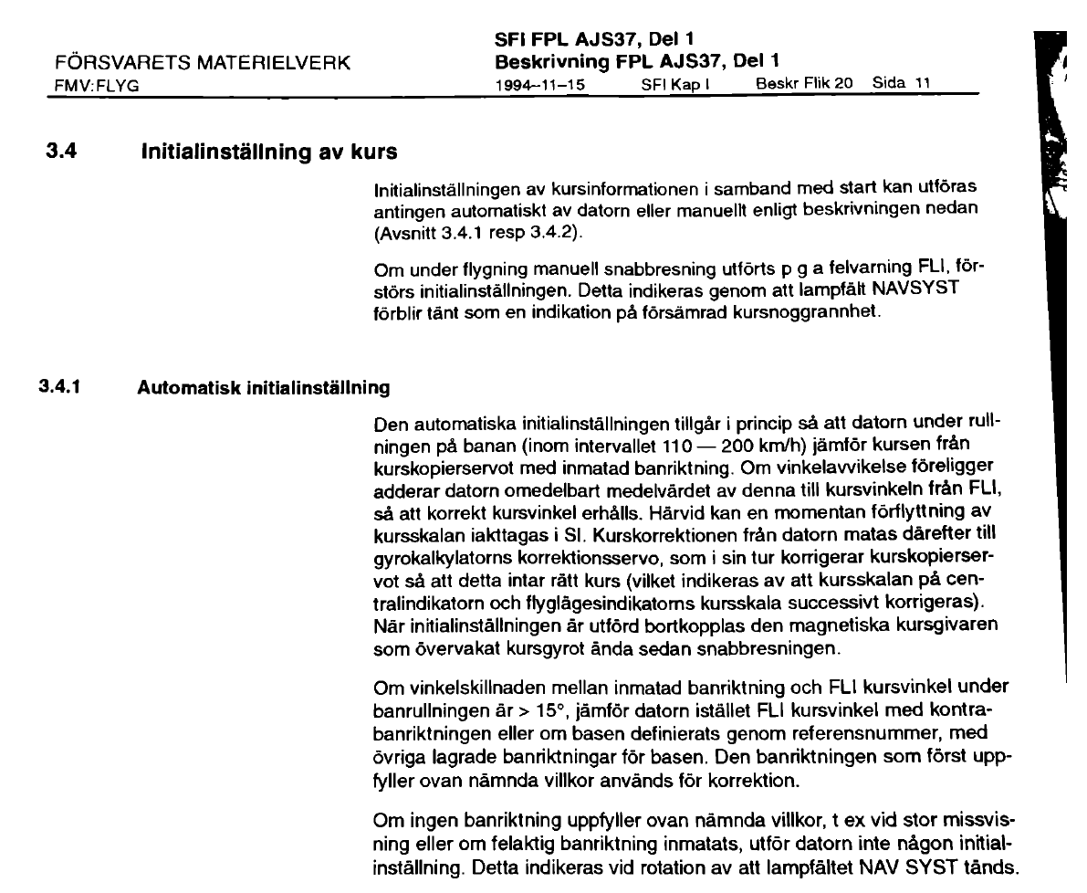
KURSKORR only affects the main course indicator, not the backup one (standby compass). The standby compass always shows magnetic heading no matter what. On the ground, KURSKORR 0 means both course instruments show magnetic heading. While in the air, KURSKORR does nothing, unless you get a CK37 failure. During the takeoff roll, if the heading shown on the main course indicator is within +/- 15° of the stored heading of any runway at the takeoff base (as entered into your flight plan in CK37), the computer says "okay, the runway heading is the aircraft's heading now". In other words, it adopts the stored runway heading as its reference. You may see a "jerk" in the HUD and on the course indicator when this happens. From that point on, the computer and hence the main course indicator are on "internal guidance" - that is, a gyrocompass with no magnetic influence whatsoever. All headings are effectively relative, referenced from the stored runway heading. If the runway stored heading was a magnetic heading then all headings are magnetic (or, well, would be magnetic if the aircraft was located at the takeoff base - local declination effects do not affect you). If it was a true heading all your headings are true. If the computer does not find a stored runway heading that matches within +/- 15° the heading during the takeoff roll, the gyrocompass is left uninitialized. Instead you get a NAV SYST warning and the main course indicator keeps working like it does on the ground (that is, it shows magnetic heading plus the correction from KURSKORR). The KURSKORR knob exists to address this issue before it becomes a problem. If you for some reason have magnetic disturbances or deviation issues in the aircraft, such that you can't get the course indicator to show correct within +/- 15° on the ground, then you can use KURSKORR to get close enough, so that the switch to internal guidance during takeoff still works. In order to check what the stored runway heading is in the CK37, go BANA/GRÄNS -> UT -> LS; the first four digits shown are the heading to within 1/10th of a degree (e.g. 123.4°) and the last two are the TILS channel. To check all stored runway headings at the base you need to first need to select it as a destination (in mode AKT POS), then go into BANA/GRÄNS UT as above and repeatedly press the appropriate waypoint button to step through the runways (including their opposing headings). If you entered the waypoint using lat/lon only the opposing heading of the one runway you've entered will be available; for full information you need to use the REF codes. All of the above is a description of the real aircraft according to its flight manual. I don't know to what extent it is correct in DCS. In Sweden, declination is never really as great as 15° anywhere, and the real aircraft had all runways on all bases stored in the computer, so in IRL procedures setting KURSKORR to 0 makes sense since it "just works". The CK37 should always initialize the heading correctly, and whatever definition of north was used for the stored runway heading becomes the aircraft's north. I had previously assumed that this north would be true north, but judging by the testimonies from actual Viggen pilots it seems that was wrong. -
Compasses showing true heading instead of magnetic
renhanxue replied to Nealius's topic in Bugs and Problems
With all due respect, that is completely contrary to how the SFI describes the nav system. The magnetic "kursgivare" is described as not having sufficient precision, and is also explicitly said to be disconnected from the main course indicator at takeoff. The system completely disregards magnetic north from that point on (except for the backup course indicator). As I described above though, setting KURSKORR to 0 does work (in Sweden) because the declination is not big enough to confuse the CK37. I always understood this as the system being referenced to true headings from takeoff because that would be convenient for navigation. I guess though if the stored heading of the takeoff runway isn't actually the true heading but rather a magnetic heading, then you get a sort of "pseudo-magnetic" frame of reference instead, where all headings in the system are referenced from the magnetic north at the takeoff base. Actual declination at the aircraft's current position in the air would not be reflected by the instruments. That seems very confusing, but I guess it could work that way?
-
Kneeboard Airbase page(s) not working on Kola
renhanxue replied to Rudel_chw's topic in Bugs and Problems
Looks like someone got excited about a Swedish map and programmed all the real REF codes from the SFI into the computer, as they would've appeared in the real life aircraft. For example, code 9001 for Hässlö airport is an accurate simulation of the real aircraft, but it's also quite useless in DCS because that airport is located near Västerås, over 700 km south of the Kola map's southern boundary. And it's still questionably realistic anyway because of course the real aircraft didn't have any REF codes for foreign airfields, least of all Russian ones... On a side note, there should now be some navigation landmark REF codes too that you could use instead of manually programming the lat/lon of waypoints into the computer, but I don't have a list of the Kola-relevant ones handy. -
Order of Battle for the Kola theatre of operations 1988
renhanxue replied to samba_liten's topic in Orbx Simulation Systems
Some additional information about the Swedish military command structure of this period. The country was divided into six military areas (sv. militärområden, abbreviated milo) - South (milo S), West (milo V), East (milo Ö), Bergslagen (milo B), Lower Norrland (milo NN) and Upper Norrland (milo ÖN). Each milo had a commander (MB) in charge of all the forces of his district; he reported directly to the commander-in-chief (ÖB) and the joint headquarters. Also reporting directly to ÖB was C E1, the commander of the 1st Air Group with all of the strike aircraft. Each milo was further subdivided into defense districts (sv. försvarsområden, abbreviated fo). I should pause here for a moment and talk a bit about delegation and chains of command. As militaries are wont to do, the Swedish cold war era military was to a significant extent influenced by the last war, that is to say WW2 even though Sweden wasn't participating in it, and the greatest fear of the military planners was a Norway/Denmark 1940 scenario where the invasion could have been fended off but the mobilization never really started and there was little to no initiative and leadership. For this reason the mobilization system had a lot of safeguards built into it - the mobilization itself was designed to be impossible to stop once it had been started ("every message that claims the mobilization has been called off is false", said the propaganda; later modified to the more famous "every message that claims the resistance has ended is false"), it was highly decentralized with depots spread out all over the country, and the chain of command had a lot of redundancy to it with a lot of freedom left to lower level commanders to improvise and manage their own area of responsibility if a higher level commander could not be reached. In the army, there were generally speaking three tiers of units. The top of the line was the "assault brigades" (sv. anfallsbrigader), manned generally by conscripts under the age of 30, with mostly modern equipment, a full complement of heavy weapons, engineering resources etc, and decent to good strategic mobility. These troops were expected to be able to both attack and defend. The second tier was lokalförsvaret, the local defense, generally manned by older conscripts age 30-45 ish and using older equipment. Generally a lot less heavy weapons and very limited strategic mobility; mostly expected to defend and delay. Manned a lot of fixed fortifications and such. Finally the third tier was the home guard, hemvärnet, and relatedly driftvärnet (idk, the "process guard" I guess?). The home guard was all volounteers, almost exclusively older men, generally equipped with only small arms and maybe some demolition charges. Driftvärnet was a weird oddity; it was made up of people who worked at defense-critical workplaces (defense industries, hospitals, power plants, transport infrastructure like the railroads, etc etc) and defended their own workplace. Returning to the military areas and defense districts: under each MB there would be both division commanders and defense district commanders, where the divisions would be made up of first tier brigades while the defense district commanders would mostly (but not exclusively) be commanding local defense and home guard units, but also various independent battalions and smaller units that were still of the first tier. In the area we're concerned with, the defense districts are: Fo 61, Västerbottens försvarsområde, all of Västerbotten county Fo 63, Bodens försvarsområde, Norrbotten county south of a line slightly north of the Lule river Fo 66, Kiruna försvarsområde, almost everything north of the Lule river, except Fo 67, Kalix försvarsområde, a relatively small area between the Torne and Lule rivers, stretching approximately up to a line Övertorneå - Överkalix - Lansjärv - Vuollerim The operational planning also talked about six "manoeuvre areas", defined as on the map: With all of that out of the way: ORDERS Bef Fo 66 Delays enemy advancing across and from the border; ranger companies are forward deployed into Finland. MASUNGSBYN and NYTORP are defended and may be given up only when ordered by MB. Delays enemy advancing over Kiruna along the railway line to Narvik and the E10 road Coordinates and supports deployment and force concentration Challenges enemy air superiority and interferes with enemy paradrops Hands over responsibility for the southern part of the Fo to the 12th division Monitors the Norwegian border Defends the power plant dam at SUORVA Deploys at least two Norrland ranger battalions north of KAITUM - NORSIVAARA - PELLO for recon and operations in the long term Prepared to: Take over the responsibility for the GÄLLIVARE area from the 12th division After the delaying action is complete, take command of actions within the manoeuvre areas Make one brigade available to the MB east of GÄLLIVARE Make fortification companies available to the MB Make Norrland ranger battalions available to the MB Assigned forces, other than own staff: 35th Norrland infantry brigade Three Norrland infantry battalions Two field ranger battalions Four Norrland ranger battalions Nine ranger companies Five border ranger companies 1st divisional gun battalion (1. fördelningskanonbataljon, bkan 1) 12th divisional howitzer battalion One AAA battalion RBS 70 Two AAA companies, one of which is the 43rd infantry brigade AAA company A ton of local defense companies, too many to list, including three fortress groups A field hospital at MALMBERGET Bef Fo 67 Delays enemy advancing across and from the border; ranger companies are forward deployed into Finland. Coordinates and supports deployment and force concentration Challenges enemy air superiority and interferes with enemy paradrops Hands over responsibility for the western part of the Fo to the 3rd and 15th divisions Deploys at least two Norrland ranger battalions east of the KALIX river for recce and sabotage activities in the long term Prepared to: After the delaying action is complete, take command of actions within the manoeuvre areas or take over the defense of a section of the coast Receive one to three AAA companies RBS 70 for deployment within the western part of the Fo Assigned forces, other than own staff: 1st SIGINT company Three Norrland ranger battalions Four Norrland infantry battalions Two field ranger battalions Five ranger companies Three border ranger companies Three divisional howitzer battalions 44th infantry brigade AAA company 7th amphibious ranger company (sv. 7. kustjägarkompani) Tons of local defense companies including five fortress groups C E1 During the delaying phase, strikes: combat engineering units, primarily ones specialized in road building, bridge building, mine clearing military bridges terrain-mobile units that are attempting to encircle our forces artillery and rocket artillery units targets in coordination with own army forces; coordination and force concentration along one of the primary thoroughfare roads should be possible to achieve. During the critical phase of the operation, strikes: enemy transport and logistics supplying and reinforcing the combat zone targets in immediate coordination with division staffs. Prepared to strike: paratroop deployments, in direct coordination with divisional staffs enemy command centers and higher staffs naval invasions attempting to reach the milo coast. Aaaand that's where I'm more or less out of time for today. I'll get to the rest later but for now, generally speaking: 12th division (core element being the 51st Norrland infantry brigade) deploys initially in the area around Gällivare and operates mainly within manoeuvre areas 1 and 4 3rd division (core elements being the 43rd infantry brigade minus its AAA company, as well as the 50th Norrland infantry brigade) deploys initially in the area around Harads and operates primarily within manoeuvre areas 2 and 5 15th division (core elements being the 44th infantry brigade minus its AAA company, the 19th Norrland infantry brigade and two independent tank battalions) deploys initially in Boden and operates primarily along the coast. More to follow.
-
Order of Battle for the Kola theatre of operations 1988
renhanxue replied to samba_liten's topic in Orbx Simulation Systems
I mean... I haven't looked at the mission file, but I was hoping I wouldn't have to do your work for you, and yet here we are. This is pre-1990. You've got the entire Kalix Line with all of its permanently emplaced artillery (mostly manned by locals), there's a gazillion smaller fortifications (I've seen the number 4000 bunkers of various kinds within the Kalix line cited in reliable sources), almost all of Boden Fortress is still active at this time with the entire city and its surroundings being closed to foreign citizens, etc, it goes on. Using that list of units from Wikipedia makes absolutely no sense, the peacetime regiments are administrative organizations, they hire people and manage training and planning but cease to exist immediately in the event of mobilization. The wartime list is just comically incomplete. In the "bible" on Swedish Cold War operational planning (Hugemark, Den stora invasionen, Medströms, Stockholm 2017), the following formations are listed as being initially under the command of MB ÖN ("milobefälhavare Övre Norrland", military area commander Upper Norrland) circa 1980: Armén 3rd, 12th and 15th division staffs including three divisional artillery HQ companies One air defense coordination staff (sv. luftvärnssamverkansstab) 61st, 63rd, 66th and 67th military district staffs (sv. försvarsområdesstaber) Nine defense district group staffs (sv. försvarsområdesgruppstaber, a "group" here is a very poorly defined term; these staffs were for commanding the mishmash of small independent units below, coordinated into larger formations) 43rd and 44th infantry brigades 13th, 19th, 35th, 50th and 51st Norrland infantry brigades ("Norrland brigades" were infantry brigades mostly equipped with tracked vehicles, specifically the Bv 206 and its variants, rather than wheeled vehicles) Seven Norrland infantry battalions (sv. Norrlandsskyttebataljoner) 1st, 2nd, 3rd and 4th field ranger battalions (sv. fältjägarbataljoner) Nine Norrland ranger battalions (sv. Norrlandsjägarbataljoner, these are lighter variants of the regular Norrland infantry battalions) 1st and 2nd independent tank battalions (24 strv 103 and 22 pbv 302 each) Three self-propelled artillery battalions (sv. bandkanonbataljoner, eight 15.5 cm bandkanon 1 each) Four divisional artillery battalions (towed 15.5 cm howitzers) Fourteen ranger companies (sv. jägarkompanier - some of these would have been forward deployed into Finland) Ten border ranger companies (sv. gränsjägarkompanier - typically mobilized primarily from police and customs personnel near the border) One paratroop ranger battalion (sv. fallskärmsjägarbataljon - also likely to be forward deployed in Finland very early on; Swedish paratroop rangers were primarily recce and sabotage focused and generally operated in small groups, no larger than a platoon) (The equivalent of) nine combat engineer battalions (The equivalent of) nine AAA battalions One military police company One SIGINT company Three ISB platoons (ISB = Indikering, Sanering, Brand = detection, decontamination, fire - chemical warfare specialists) 2nd strike aviation company staff (sv. attackflygkompanistab) Six helicopter platoons (mainly medevac, but the 5th anti-tank helicopter battalion equipped with hkp 9 and HeliTOW was being set up in 1988) Seventeen independent bicycle infantry battalions (sv. cykelskyttebataljoner) Thirteen local defense artillery companies (sv. lokalförsvarsartillerikompanier - these guys would be manning the artillery forts) (The equivalent of) 45 fortification companies (sv. värnkompanier), mostly manning various smaller bunkers and fixed guns (lots of old tank turrets emplaced in the ground etc) Ten logistics battalions (sv. etappbataljoner, idk how to translate this, they're not strictly logistics, they're for supporting a brigade on the march I guess) Several fort groups and their equipment (this is just the Boden Fortress, really) Eight field hospitals If the enemy was attacking only though Upper Norrland and not anywhere else in the country, two more army divisions were earmarked to be placed under the command of MB ÖN. Marinen Only thing within the scope of the map really is the coastal artillery, specifically the Luleå locking battalion (really no idea how to translate this, sv. spärrbataljon, it's a coastal artillery unit that defends a fairway into a harbor and typically operates a number of fixed artillery pieces and a whole lot of pre-placed fixed naval mines etc). Flygvapnet 211th sector staff and its air combat control battalion (sv. stridsledningsbataljon) Nine base battalions 41st and 211th fighter squadrons 212th and 213th recce squadrons 55th recon group (sv. spaningsgrupp) 211th transport aviation group 211th aviation group (ok this is a total cop-out of a translation, it's probably VIP transport aviation; sv. sambandsflyggrupp) 211th and 213th helicopter groups (mainly pilot SAR) Five light strike squadrons (delegated from E1) If the enemy was attacking only though Upper Norrland and not anywhere else in the country, one more fighter squadron would be placed under the command of MB ÖN. In total across all branches I'd estimate around 150 000 personnel. A problem with this, of course: it's from circa 1980, but few details are known about later plans. Still, the unit assignments should be mostly the same up until the early 90's when everything suddenly started changing very quickly. Oh, and this is just the default initial assignment; more troops could be transferred north as needed and there were plans and a strategic reserve earmarked for this. Not all of the units initially placed under MB ÖN would be mobilized locally. Many of the units (especially the local defense ones; second line formations made up of older conscripts, with little strategic mobility) would have all their heavy equipment stored locally and the personnel would arrive with personal equipment only. Most personnel would be arriving by train, so either by the east coast main line to Boden or by the old inland line to Arvidsjaur and Gällivare. Most mobilization points would probably be relatively close to a railway, so Älvsbyn, Arvidsjaur, Luleå, Boden, Murjek, Gällivare and Kiruna are likely to have been the main mobilization areas within the map. The operational planning talks a lot about "The Rectangle", that is to say the approximate area between the four cities of Boden, Luleå, Piteå and Älvsbyn, which was kind of the main base and supply area. Mobilization was generally highly decentralized though and local defense troops would mobilize near whatever thing they were supposed to defend. Think places like Kalix, Morjärv, Överkalix, Råneå, Niemisel, Tärendö, Vittangi, any place with a bridge over a major river that isn't the Torne river really. Torne river was considered "a bridge too far" and was not a line to be held. Units like the border rangers that mobilized very far east were expected to fade into the woods and more or less immediately transition to "independent warfare" (sv. fria kriget, basically guerilla warfare with a fancier name) after the Soviet spearheads had passed them by. MB ÖN himself and his staff would have initially have been deployed in the fortified GPL "Bo" (GPL = grupperingsplats, deployment location; Bo is just a code name) in Kvarnberget near Korsträsk (if you zoom in really far exactly on the map marker you can just barely make out the metal "clothes hangers" that were supposed to hold up the camouflage netting over the portal; this bunker is long decommissioned and has been sold to a private owner). The area around Älvsbyn was in general littered with various underground facilities, such as a gigantic fuel storage depot in Kälsberget (remind me to do a post on these sometimes, there were a lot of these all over the country, they were huge and very cool) and an ammunition/equipment storage in Hundberget (approximately 3500 square meters of storage area inside, according to its current owner). This doesn't answer where all of these units would go, of course, but to find that out we'll need to dig down into the operational planning and examine the orders. Fortunately the book contains an entire chapter on this by general (ret.) Bengt Gustafsson, who was MB ÖN 1984-1986, so that should be almost up to date. That'll have to wait for another day, though. -
Order of Battle for the Kola theatre of operations 1988
renhanxue replied to samba_liten's topic in Orbx Simulation Systems
The AJ and AJS 37 Viggen were strike aircraft and were not equipped with the Stril 60 data link. Only the J 35 and the JA 37 were. So just plain old GCI will do.