Case
-
Posts
1138 -
Joined
-
Last visited
-
Days Won
8
Content Type
Profiles
Forums
Events
Everything posted by Case
-
From the brief look at the Tacview code I had this morning all it did was convert latitude and longitude to x and z, so we can easily change the Tacview code to have it write out the data on an x, z plane.
-
I have the files for Nevada, but they need a different scaling as the highest point is very different. Rerunning Tacview will have to wait till tonight :)
-
Right now the model is sampled at 1200 points over a degree, so 3 arcsecond spacing which amounts to about 92m spacing between points. The combined file size of all 45 images is only 4.9MB I'll rerun the Tacview script with 1 arcsecond spacing (3600x3600 points), which should increase the size to about 50MB, which should still be workable. Sure, check http://www.mediafire.com/?natolw1ai9mh87n.
-
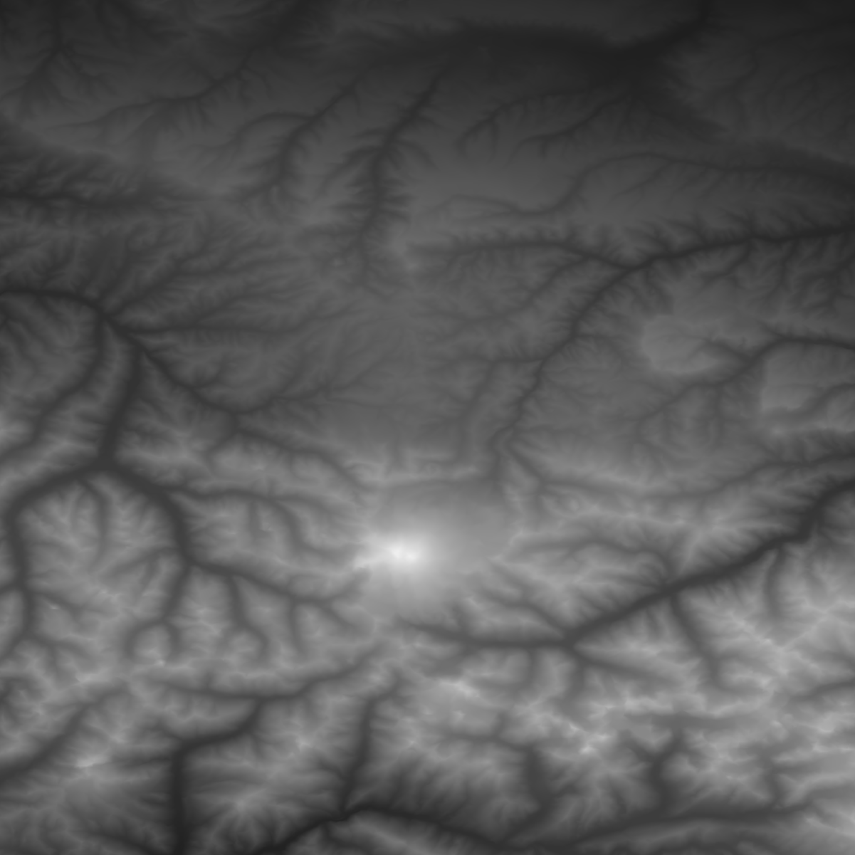
I converted the elevation data that Tacview outputs into 8bit grayscale PNGs (still figuring out how to do 16bit). Here's an example of the 1x1 deg tile containing the Elbrus. The PNG file is 382kb, which is a very big reduction from the 26MB file Tacview wrote.

-
Great find m0j0! It in fact uses LoGetAltitude, so this is exactly what Yoda wanted to do. I just ran it and in about 5 minutes it generated 1.3GB of hgt files in a 1201x1201 pixel grid covering 1x1 degree. Great stuff!
-
Yes, that is what I meant. Just checked, the highest point on the map (Elbrus) is at 5642m, so with a 16bit color depth you're looking at better than 0.1m vertical resolution, which may already be more than you need.
-
Do you need just one zoom level or multiple? Ideally you would want to render a fixed number of pixels, so that if you are zoomed out you read the data from a different set of images compared to being zoomed in. You would then have many more images for the highest zoom level, but you could work out the administration so you only have to load those that are only needed to show the particular area of the map you are looking at at that time.
-
Ok, if that is what you want to do then the sub region idea would work very well. It sort of resembles Google Maps, which has several imagesets for specific zoom levels. Probably the easiest way would be to store the data in some sort of image format, where in x and y you have the pixel numbers and in z you have the altitude represented as a color (hence it would be a grayscale image). This approach also gives you the added benefit of many libraries that can read and write data and also compress it. I would first generate the images on the smallest scale, and then you could just use Photoshop or similar to rescale the images to the larger scales.
-
So you just want to make an altitude map for different spatial scales? Can you confirm that you are not trying to use the map to determine if two points have a direct line-of-sight?
-
Yes it is possible, but we do not want to do that. We prefer to use the GCI software only during controlled events to ensure that no one flying on the server is also using the GCI software to see where everybody is. In these controlled events we only provide the GCI passwords to specific people and make sure that they act as GCI only.
-
Yes, we'll do another GCI weekend at some point. The hard part is mostly to arrange for people to act as GCI controllers (and convince them not to fly), and get a critical mass of people on teamspeak to make it worthwhile.
-
Ah, you mean this 14.5mm shell from a BTR-80? Good to hear the passion was there! Edit: I missed the 30mm from a BMP-2, that probably did even more damage :)
-
Thanks for these Riptide! Rage quit? What happened?
-
A big thanks to all who flew on our server during the GCI weekend! Today we ran an 80's mission where the score was much more balanced now that the F-15 loses its dominance. Part 1 Part 2 If anyone is interested I can run an ACMI of the track of the second part.
-
Again, we'll provide human GCI control on our server tonight. Join our TS3 server at 51st.hopto.org:9987 and our FC2/BS server at 212.37.145.18!
-
Hi IronMike, Just for the record, X-man acted as RED GCI for the first half of the evening. Yes, the stats for this battle can be found here: http://www.51st.org/stats/battlestats.php?starttime=2011-07-29%2018:02:59&endtime=2011-07-29%2022:47:52 Unfortunately the overall score for RED was so low because a few people loaded up R-77's on their Su-27's which we do not allow on the 51st server. For each illegal missile they launched the get a -15 penalty, which causes the unfortunate low score. And a very big thanks for you for acting as BLUE GCI! Edit: Here's a link to the ACMI I ran of the server track: http://www.mediafire.com/?w6xni99xg9czy4h I had great fun with Vecko, X-man and Frostie trying to lure blue guys into our little trap near Tuapse :)
-
Thanks for all that joined in tonight! I controlled the red coalition for a while and it was great to direct pilots. Here's a screenshot of my LotATC screen and the people on the TS3 server.
-
The server is up and running with GCI enabled. Join our game server at 212.37.145.18 (<51>SERVER) and our TS3 server at 51st.hopto.org:9987!
-
I wish you a speedy recovery :D
-
Maverick, Crunch, feel free to bring in a controller from the 104th :smilewink:
-
The 51st PVO Regiment will host a GCI weekend on our dedicated FC2/BS server. When: Coming weekend, September 9 to 11, evenings from 1700Z. Where: 51st PVO FC2/BS Server [212.37.145.18] 51st PVO TS3 Server [51st.hopto.org:9987] We will try our best to provide GCI controllers during the evenings of the weekend, starting from 1800Z. Using the LotATC v3.0.0 software, controllers will be able to direct flights/aircraft to the battle area and provide increased SA to participating pilots. Everyone who joins our Teamspeak to fly the event will be given a flight callsign and a specific TS channel in order to keep the communications organized. Anyone who doesn't want to fly with GCI support is free to join the server as usual, but we encourage everyone to join as it's much more fun Our controllers will be using English and will not provide GCI in any other language.
-
The bulk of the resupply is done by Russian Progress spacecraft, but both Europe and Japan send cargo craft up to the ISS regularly.
-
Some really really really cool pictures from the International Space Station showing Atlantis during re-entry! http://spaceflightnow.com/shuttle/sts135/reentry/
-
Apparently they only started doing this recently. The paintjob was indeed cool, but not as cool as the orange lion on the Dutch F-16. Of the 4 F-16 displays I saw yesterday the Turkish was best, followed closely by the Dutch one, then the Danish and the Belgian displays.
-
Some pictures from the Ukranian Su-27UB. It was from the 831st at Mirgorod. I got a chance to sit in the cockpit and walk around the airplane. Unfortunately I wasn't allowed to take pictures from inside the cockpit.