Sgt_Cyanide
-
Posts
58 -
Joined
-
Last visited
-
Days Won
1
Content Type
Profiles
Forums
Events
Everything posted by Sgt_Cyanide
-
So guys, I have fixed zoom bug. I'll fix some of the other problems over the weekend. Link: https://drive.google.com/file/d/1WXuNu1NyAGS1r-asVwPGmCnl_7fEfn5z/view?usp=sharing PW: DMP
-
Nice to hear! Don't be in the plane, while exporting. Init.lua loads when the ajs 37 spawns. I usually do it like this: - Open kneeboard, select appropriate data cartridge ID. - Insert data cartridge into the slot. - select Ref/lola, input 9099 - push LS/SKU - Wait - switch to output and akt/pos - Hit LS again for start waypoint - Do a plausibility test
-
It needs to be exactly like this for now (see screenshot below).

-
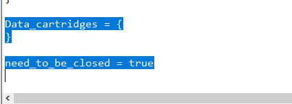
Ok, I could reproduce this error with four different settings. Please check the following: - Trailing/leading whitespace infront/behind "Data_cartridges = { " - Trailing/leading whitespace infront/behind "} " - Missing "Data_cartridges = { }" - "Data_cartridges = {}" Please look if one of those is matching :).
-
This seems right. Strange, what happens if you take my sample file and place it in your dcs folder and try to import it?
-
If you can attach the lua file I'll take a look on it. Maybe I'll spot what's wrong or you can take the init.lua in the documents folder. It's a sample file that I used.
-
I think I know what's going on. I'll fix it as soon as I'm at home (ca. 16:00 UTC+1) and re-upload it. Sorry.
-
Thanks for pointing me at his thread. I already noticed that the east part of the DCS map is missing. But I can implement every map that has a proper png format with a high resolution. If we can find another map that covers the whole area I can load this. Maybe I'll include a offline openstreetmap map of the whole area, so you can choose between maps. We will see. But for now it's a good start I think! ---------------------------------------------- Here is very very early version of the planning tool. Don't expect to much for now. There is only im- exporting, waypoints, target waypoints and a basic QFE calculation. Expect some bugs and null pointer exception if you aren't cautious. :) There is a short manual in the documentation folder and a sample init.lua file if you have problems with im- exporting. Please test if the map Lat/Lng is aligned and give me some feedback. The UI will be better with time! Link: https://drive.google.com/file/d/1WXuNu1NyAGS1r-asVwPGmCnl_7fEfn5z/view?usp=sharing PW: DMP
-
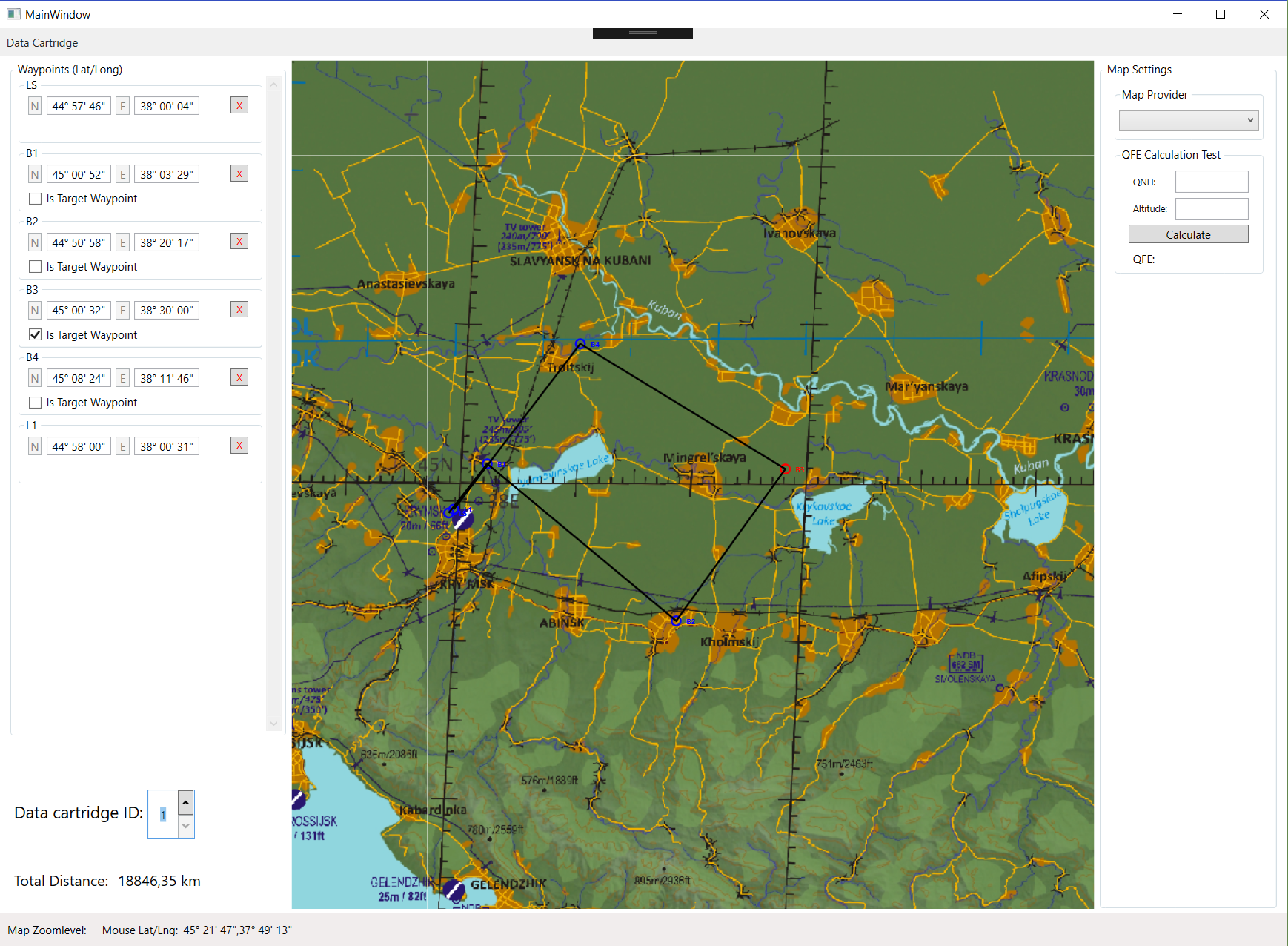
It would be nice if you can give me the whole link to the map or the name from this guys, so I can give him credits for the map :). So guys, short update from today. I have rewritten a big part of my code to implement the DCS map. I think this time the Lat/Lng is very good aligned, but it needs some further testing. Screenshot below.
-
I need it in an .mbtiles format with an WGS 84 (EPSG:4326) spherical mercator. Currently I have success converting the map in a .mbtiles format and I'm checking if the latitude and longitutde are identical to the DCS map. So many new things to learn. :unsure: But it makes fun. -------------------------------------------------------------- Edit: I have successesfully imported this map into my application. Some coords are slightly off, but I'm working on it! I've attached a screenshot for you guys. Please ignore the total distance, it's a tiny bit off.. :megalol:
-
Wow this map is awesome!! Thanks for sharing. :thumbup: Totaly trying to convert this map. If the conversion is working I have to rewrite my map renderer.
-
If you don't like it, simply don't use it. I don't know any way to use the F10 map of DCS. That would be awesome when we could use it. The only one who can make a serious and precise tool are the developers of this simulation it self. They have much more knowledge than me and the real map from the game. I'm experimenting with some maps exported from DCS but the aren't looking that great.
-
So guys, I have finished all main parts of the software. Currently I'm testing it for bugs. And looking again how I can download the caucasus map for offline use. Thanks for your patience!
-
Yeah thats right. I made sure that the bandwidth usage was as low as possible. That means I don't use high zoom levels. This shouldn't be a problem when planning the waypoints. I wasted all day downloading the map of the caucasus locally and integrating it into the mission planner, but I can't get it to work. Maybe I'm too stupid. They should make it easier for developers somehow. At least I tried! Small update for today: I finished the importer. This allows you to import all five data cartridges into the tool. You can then edit them and export them to DCS again. Next step is to implement some user settings, to point my app to the location of DCS.
-
This sounds good, but I have found a tile usage poilcy which means: "Heavy use (e.g. distributing an app that uses tiles from openstreetmap.org) is forbidden without prior permission from the System Administrators." I doesn't know If my application causes heavy traffic. The maps are not 100% aligned, but thats not a big problem. You build your flight plan mostly visual. A problem is that some small island are not existant in DCS. The only important waypoints are target waypoints. I recommend you to input lat/lng manually by looking at your mission briefing. Targets for the AJS37 are mostly known (strike). If the developers are implementing data cartridges for the plane, I can adjust my export for the particular airplane.
-
Thanks for the great feedback so far! I'm a little bit concerned about the map usage of my application. I don't know if I'm violating their terms of use from the map providers. Can someone help me out on this? I'm not that smart to understand terms of use. :huh: My application uses OpenStreetMap currently. Short Update: Today I have finished implementing the Export. Tomorow I'll start to look at the Import.
-
Yes he was working on this, didn't know what happend and I can't wait forever for such a tool. I really would like to do that, but currently we are restricted to normal waypoints. I've ask what is possible to pre configure with a data cartridge, but I doesn't have an answer yet. Setting BX waypoint would be really nice. Thanks for the short explanation, it's way clearer now how I can calculate this! I'll try something, maybe I can develop something that displays QFE for every waypoint. :book: Today I have finished to create a whole new UI which allows to select different data cartridges (max. 5 Slots). Tomorow I'll start developing the im- / exporter. Short video for you guys:
-
The first release could come without QFE calculation, but I'm definitely looking how I can solve this. The weather data should be on the briefing page of the server. I'll let you guys know if I found a solution. Update: I made a big progress on how I handle the waypoints, it's now more stable and there are 5 configurable flight plans that you can select and edit in the UI.
-
I think it should be possible to implement pre planning on Nevada. But currently this is not implemented. The reason is, that I don't own the Nevada terrain at this moment.
-
I'm currently developing a more solid waypoint system for more stability and a nice UI. I'll release this tool with basic features, where you can create a basic flightplan with target waypoints, as in the video. It shouldn't take very long to get this stage. Stay tuned.
-
Hello everyone, I would like to share my concept of a pre-flight planning tool, that helps creating flight plans for multiplayer sessions for example. It's possible to manually input latitude/longitude if a target is known. Later I would like to develop a possibility to share flightplans via file import/export. Currently I don't have any knowledge to display the real DCS Caucasus map. This causes that some roads, mountains or island are a bit off or not existent. Short test on the OpenConflict server where successfull and it's very convenient that we don't have to restart the game after altering a flightplan. Just change your flightplan and hop in Viggen, load the data cartridge and go. Link to my concept: Mission Planner Download Please keep your previous version of the tool, in case something is not working. Version: 0.0.2: Link: https://drive.google.com/file/d/1XlVXP4dDMYNrQHm1Qb3HCm7-kBwtKmSL/view?usp=sharing PW: DMP Very early release. Version 0.0.1: Link: https://drive.google.com/file/d/1WXuNu1NyAGS1r-asVwPGmCnl_7fEfn5z/view?usp=sharing PW: DMP
-
Can't hit with the Radar Release Mode
Sgt_Cyanide replied to Sgt_Cyanide's topic in Bugs and Problems
Thanks for your help! I think I get it now. I have totaly forget to look in chucks guide. :doh: -
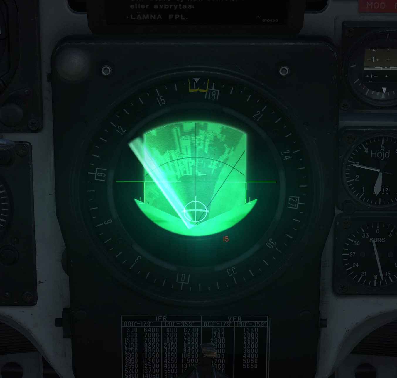
I was trying the Radar Relase Mode with the M/71 Bomb low-drag, but I can't get a hit near my targets. Flight altitude was 400 meters. No wind or bad weather. 1. I set up the QFE correctly and I have fresh up-to-date nav system. 2. Switch the weapon selector to RR and the master mode to ANF. 3. Turn the Radar to mode 1. 4. If a saw the ground targets on the rader -> trigger unsafe. 5. When the target passed the 3km mark, I press and hold the weapon release button. 6. Bombs are impacting about 1-2 km behind my targets. Whats wrong with this procedure? :huh: Holding the trigger when target passes the cross (picture in attachment).
-
I have made a short video how to do ELINT, based on the information i got from this thread. :joystick:
-
I did not draw this in the F10 map. I created those corner points on the ingame map and took a screenshot, then I paste the screenshot in mspaint and draw the lines.