Tengu
-
Posts
57 -
Joined
-
Last visited
Content Type
Profiles
Forums
Events
Everything posted by Tengu
-
Kiowa Warrior combat pilot Adam Korinek fondly recalls the OH-58
Tengu replied to gdotts's topic in DCS: OH-58 Kiowa
@Flagrum... Yes, I think if you approached with the wind, the wind would better transmit the noise of your approach. But the pilot's quote says "approach a target FROM downwind", so that's sounds like moving upwind to me, ie the opposite of your interpretation. -
About a year ago, I was reading about the 70s Dhofar insurgency in Oman. I'm sure there are others that have an interest in small bush wars and lesser known histories. I immediately thought of the C-101 as a stand-in for the SOAF Strikemasters. But within DCS, I never did anything more than ponder the possibilities. Unfortunately, Dhofar and the vast majority of Oman are well south of the PG map. I envisioned an alternate history where the late 80s / early 90s Sultanate of Musandam and Gamrun (one spelling of a former name Bandar Abbas) straddled the Straits of Hormuz and experienced an insurgency on the north side. Honestly, in the campaign, I wanted to fly out of Khasab and past those fjords each sortie. Musandam is just too small to be the entire state, so I effectively annexed the modern day Iranian province of Hormozgan. (There's actually some precedence for this during the 1600s thru 1800s.) It would also have kept me flying north and well away from those ultra modern glass towers in the UAE. At the time, the alternate Sultanate still made fair use of contract officers and I envisioned the same Jordanian C-101s might have been leased or donated to the cause. Material support to the insurgents came from the Soviets in Afghanistan or the Chinese via Pakistan. The Iranians (minus Hormozgan) were otherwise busy with Iraq, which would undoubtedly explain the porous borders. In the Syria map, you could easily go with the present day and save yourself all the historical gymnastics to engineer a viable conflict. And according to Wikipedia, Jordan has retired the C-101. They might have been donated to a proxy group inside Syria or perhaps purchased by PMC contracting in the region. You'd need to stay in the more permissive air environments.... hope our intel is solid. Some of your missions might include: 1) performing patrols to work up in the area and and eventually interdict supply lines, 2) re-imagining a Battle of Mirbat or perhaps Battle of Kamdesh (The Outpost) type scenario where either your CAS or perhaps FAC services stave off certain defeat of embattled ground forces, or 3) catching some elusive Katyusha's firing on allied camps at sunset. For inspiration of the last, here's an excerpt from Ch 7 of "In the Service of the Sultan: A First Hand Account of the Dhofar Insurgency" by Ian Gardiner. "Because of their range, usually the only counter to the Katyusha was an air strike. However it took time to rustle up an air strike and, in the time it took for a Strikemaster to appear, there was every chance that the adoo would have finished firing and moved the firing point. Moreover, the adoo would wait until evening before they fired their Katyushas. Since they were firing from the west eastwards on to our positions, this meant that the sun was in our eyes, and the horizon would be hazy and indistinct, making it almost impossible for us to identify the firing point. Although the Katyushas were essentially line of sight weapons they could be fired from a reverse slope which we could not see. Unlike a mortar, there was no warning 'pop'. However, if one was extremely lucky, one might be able to spot an initial trail of smoke. So we took to arranging for aircraft to be in the air just before sunset, out of sight and sound but close enough to be called in at a moment's notice. This Katyusha trap worked on at least one occasion."
-
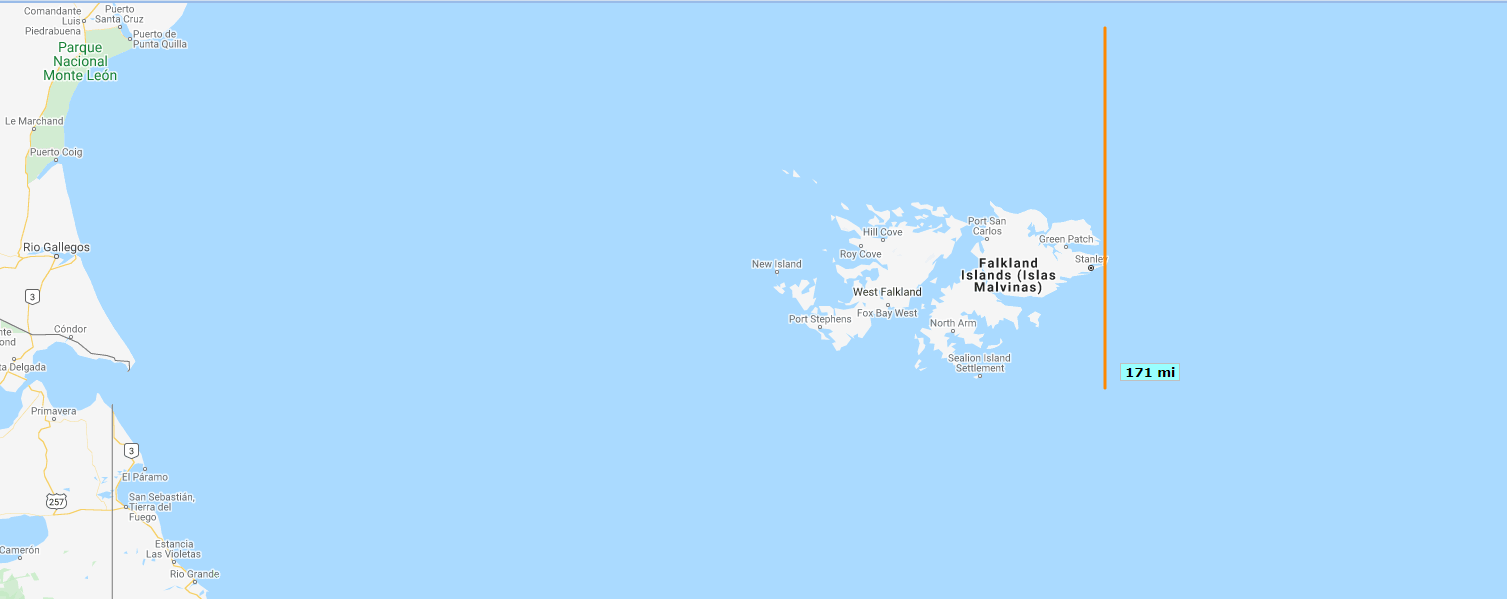
For those of you much smarter than me, is there any technical reason requiring the map edges to be strictly oriented to primary compass directions? Also, Raz_Specter says "flyable", but that probably means fully detailed, right? The attached image depicts the area. The rough extent (by my uncalibrated eyeball) of this cropped map west to east is ~700 miles / 1150 km. Stanley is ~120 mi / 193 km south of Santa Cruz's line of latitude. Assuming a north to south limit of 140 mi / 225 km, you could get get as far south as Fox Bay West or North Arm holding Santa Cruz as the northern edge. To get the entirety of West and East main islands, you'd need ~170 mi / 275 km while still holding Santa Cruz as your northern edge. That's what my orange line depicts in the image. That said, the stated 1150km by 225 km is decidedly ribbon like, and just angling the ribbon could easily put Rio Gallegos in the lower left corner and say Puerto Santa Cruz in the upper left corner while squarely bracketing the entirety of the Falklands / Malvinas. Rio Gallegos and Puerto Santa Cruz are only 185 km by air. I'm in no way representing Razbam, but I think that a 1150km by 225km rectangle could be drawn that captures the entirety of the islands and two continental bases (Rio Gallegos - Mirage IIIEA, A-4P, IA 58 Pucara and Santa Cruz - A-4P; aircraft types from wikipedia). For sake of reference, I extended the southern edge far enough south to show Rio Grande. San Julian is 30-40 mi / 50-65 km north of this cropped image. These would appear to be outside of any hypothetical 1150 by 225 km box that held both Rio Gallegos and the Stanley.

-
Wow. I love this idea and what a thorough case for it! +1 The proximity of the mainland also allows more feasible red / blue areas. I like the South Atlantic project, but would I actually fly from Rio Grande to Port Stanley and back if I'm going to the office the next morning? In a modern (2000s) incarnation, is this possible from a performance viewpoint? An honest question on my part. There's plenty of water yes, but also tons of trees and urban areas. Even more so if you try to grab big chunks of the mainland coast.
-
Updated manual and other goodies from Baltic Dragon
Tengu replied to baltic_dragon's topic in RAZBAM
Excellent. Thanks for the new manual Baltic Dragon! On page 216 (about the NVGs), I assume the yellow highlight was something missed in editing? This is a very minor nit, but perhaps something to look at when it's time for the next revision.