Comrade Doge
-
Posts
350 -
Joined
-
Last visited
Content Type
Profiles
Forums
Events
Everything posted by Comrade Doge
-
 Hello, I hope it will suit you well! For the Harrier, I will be definitely looking forward to adding support for it, next modules coming now would be the Mirage, Black Shark and Gazelle currently.
 -
They way I figured it, it displays everytime you transfer waypoints to a hornet... Will it be a bit too spammy?
-
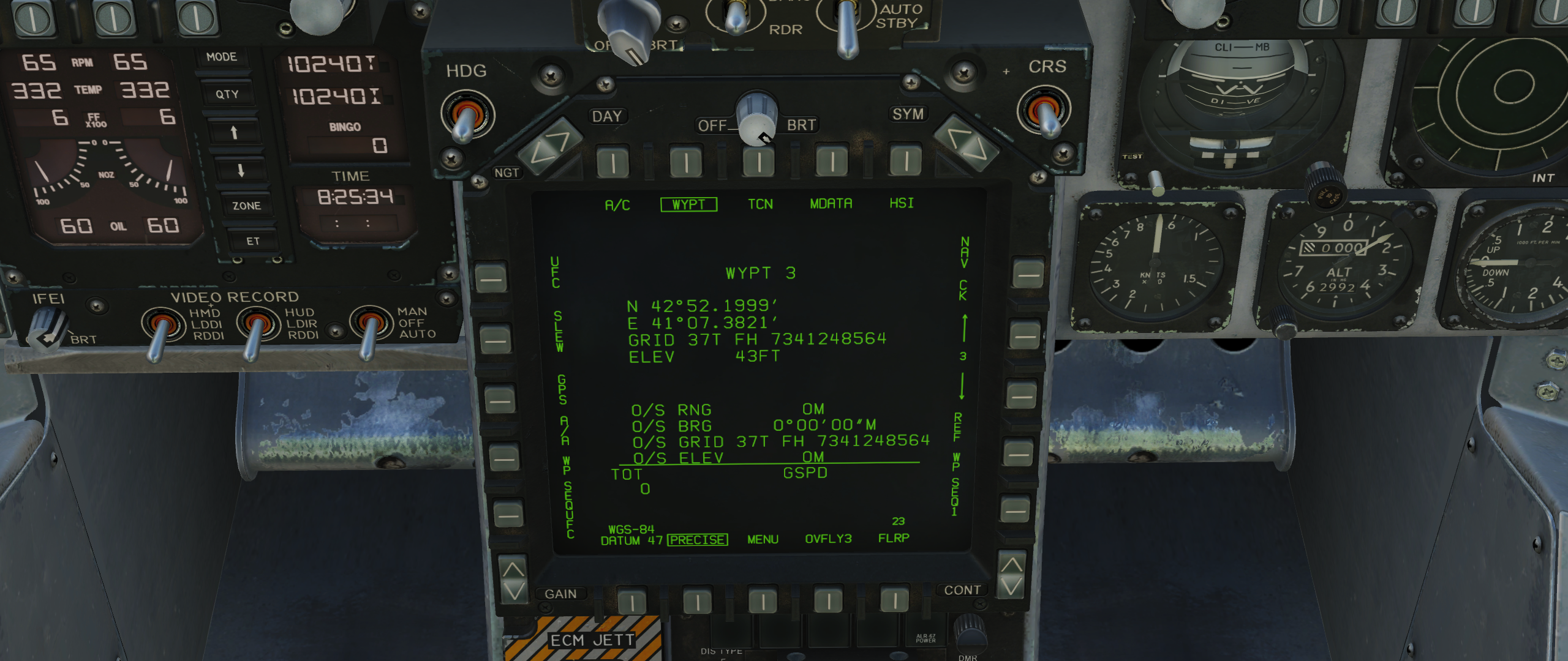
What do you guys think about this new GUI? I also made sure to remind Hornets to select PRECISE first manually

-
Hello, a fix is underway. The bug arose as I did a major code rewrite as well... In the meantime, check if minimizing the window helps
-
Hey! Good work! Unfortunately I will be away from my PC this coming weeks, I will check it out once I will be back...
-
Hey! I appreciate the kind words, let me know if you encounter any issues with it!
-
Oh those... Those are internal DCS codes for all the buttons, so that I can press them super quick and without the user needing a certain keybind... I get those from the DCS-BIOS repo, since I cannot find them for all the planes I don't own... Here is an example lua file containing those for the F-16: https://github.com/dcs-bios/module-f-16c-50/blob/master/F-16C_50.lua And an example snippet from there would be line 264: definePushButton("ICP_AA_MODE_BTN", 17, 3018, 169, "UFC", "ICP Master Mode Button, A-A") Which shows that the master mode button uses the device 17 (think it as the cockpit "area" or panel the button is on), and the button code is 3018. I definitely could use knowing the codes for the bindings needed for other planes...
-
Thank you for all the feedback. Next time I will make sure to disable the Precise button pressing, and show a popup on the GUI reminding the User to turn it on themselves. Waypoints not being cleared after transfer has the logic that if you die, you can respawn in a new plane and enter your existing waypoints again, without needing to select them all... However the dot remaining on screen is not intentional, I did some major code refactoring as well, that must have slipped through... For the Nevada and Marianas, I plan to fix that as well, it needs more work however, since I have yet to figure out a way on how to get the coordinate system used from the map... Hopefully I will have time to do all this before the trials expire, so I can test all of it out.
-
Hello again, I know it's been really soon after the latest update, but here is a new one! In this version 2 very highly requested things were added: A10C and A10C2 support Hornet PRECISE ( there is no need to enable that option manually, it's all done automatically ) I'd appreciate feedback regarding the functionality, especially since I do not own neither the Hornet or the A10, and I developed these functions using the free trials, so any bugs that may be have to be pretty much fixed until they expire... I hope you all enjoy it, download the latest version from here: https://github.com/aronCiucu/DCSTheWay/releases/tag/v1.2.0 If you are updating from an older version, simply replace your existing TheWay.lua and TheWay.exe files with the new ones.
-
Hello all! After quite the break in development, The Way got a new much needed update. This includes: Added automatic elevation entering from the map Sped up Hornet waypoint input Waypoints no longer get wiped from the GUI after being transferred Download the latest release from here: https://github.com/aronCiucu/DCSTheWay/releases/tag/v1.1.3 If you are updating from an older version, simply replace your existing TheWay.lua and TheWay.exe files with the new ones. I hope you will enjoy it! Next up in the pipeline will be Hornet precise coordinates! Stay tuned and thank you for all your support!
-
Thanks for the input, actually I plan to get the elevation from the waypoint on the map, and have that be entered automatically... If that is not possible, I have other plans to integrate it into the GUI... Thanks to all your support, I will try and get up to speed with the project again, I've been neglecting it recently.
-
Thank you for the help! What button would it be to activate precise mode? I can press any button in the cockpit so that the user doesn't have to...
-
I see... Well, I have some buddies that helped me get hornet support in the first place, I will reach out to them again and hopefully I can get that in as I see it's highly requested... Also some very helpful contributor to the GitHub page kindly added A10 support so that will be in as well soon! I am happy about all your support here, that will definitely motivate me to add more features in the near future.
-
Hello, you will find that the F-16 coordinates are extremely precise, as for the Hornet, unlikely it will improve, as I do not have the module nor fly it....
-
In the above document, I find 2 interesting paragraphs about the landing flaps: "The MAIN flaps extend proportionately with flap handle position." and "In the sim, there is no reason to assign an axis to the flap control. Essentially, the landing flaps are full up or down." This confuses me, on one hand the MAIN flaps move proportionately to the handle, on the other hand, the other line says it's either fully up or down. I'd appreciate some further explanation...
-
Hey all, it's been a while, mainly because I've stopped flying the modules I made the program for... I've heard many of you ask for VR support. The problem is I don't own any VR hardware, and therefore you cannot see the GUI of it... However there is a chance it can work if you can somehow click on the GUI and approximate where the center of the map would be. Cheers!
-
Hello everyone, to address some inquiries here, I will be maintaining the application in the future, just this time period has been extra busy for me... Elevation is planned to be added, Nevada indeed has issues with the coordinate system, hopefully I can fix that as well... As for multimonitor setup, it's curious since I use multiple monitors as well, will have to see the issue more in detail, preferably images... VR support is unfortunately not planned as I do not own any VR gear currently. Thank you to all for the support, hoping to find time to work on it soon!
-
Hello, I will be somewhat busy this following time, afterwards I will resume adding new things, particularly being able to copy and paste positions.
-
Hello, it just doesn't set it for now...
-
Hello everyone, thanks to all your feedback, I have published a new version of TheWay, in which waypoint accuracy is vastly improved when selecting from the F10 map, especially when zoomed in. Also includes lua fixes to avoid certain errors. Download this release from here: https://github.com/aronCiucu/DCSTheWay/releases/tag/v1.1.2 If you are updating from an older version, just replace your existing TheWay.lua and TheWay.exe files with the new ones from the latest release. Cheers!
-
Aha I see. Well in the future I plan to display a list of the points selected, and to be able to edit them and copy their coordinates, to paste then where ever you want. This will be combined with the requests for having elevation and being able to paste coordinates into the prgram as well, in a later version
-
Hello, thank you for the kind words, my work is compensated when I see people enjoying the program! As for your suggestions, I tried to implement the keybind part, however it seems like Windows does not allow other programs listening for keybinds if they are not in focus, so I'm afraid I don't have the means to implement that yet ... Maybe in the future I can find a way. The program should sit on top of DCS by the way, so no alt tabbing required to it. As for the elevation and selectable units, I have this in my to do list, today I will also launch an update to improve the accuracy of the waypoints... You mean being able to paste the coordinates from a scratch pad directly into the program, instead of selecting from the map?
-
Hello, first of all make sure you have the latest version of the program, some Hornet fixes have been made. Also elevation indeed remains unchanged, it is not taken from the F10 map... The waypoint transfer begins with the next one after the one you have selected, so if you are at 1, it will begin filling up from 2. As for the first waypoint being repeated, that's something I haven't heard of yet, if you could send a video so I can see it would be much appreciated
-
I see, well, it's definitely on the list for a future update, I can see the need for typing exact numbers.
-
Well, it starts adding waypoints starting from the waypoint you have currently selected. So if you wish to override your existing steerpoints, select the first waypoint, and it will override. If you want additional waypoints to those you already have, select the last waypoint in your plane and it'll add after it