buur
-
Posts
641 -
Joined
-
Last visited
1 Follower

-
einfach als doscript mit Missionsbeginn starten. Würde das letzte Script in dem Thread nehmen. Musst du nur die Base-ID raussuchen, ist zwei-drei Beiträge vorher beschrieben. Wenn's nicht klappt sag bescheid, dann bastel ich dir eine Beispielmission
-
Scheint nur über ein event hit zu gehen. Hier hat das mal jemand beschrieben.
-
Also ein event 'Bomb hit runway' kenn ich jetzt nicht. Am besten wie von AirWolf beschrieben eine rechteckige Zone um die Runway machen und abfragen mit dem Trigger 'Bomb in Zone'. Ist für viele Spieler und unterschiedliche Bomben etwas nervig abzufragen, aber wenn du das vermeiden willst must du zu Moose oder Mist wechseln.
-
This are simple script files which could be added to every mission (but needs Moose to run). Simply unzip the missions and take the needed script. This are the fixes from the NS430 database and no additional ones. (Maybe have to check if the NS430 database now contains more fixes. The files are now 2 years old) Wondering about the airbase because airbases are not in the database but dynamically loaded from the map files. Sounds more like a DCS bug for me.
-
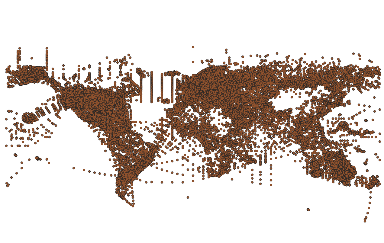
 For the waypoints: The main problem is that nobody knows from which year the database is but is definitely not an actual You can read out the database and import the fixes to GIS systems like QGIS. In total there are about 130.000 (see picture). But this didn't help if you are not willing to produce your own maps. (Which is of course difficult in DCS). In this thread I posted the fixes for some maps for the F10 Map. But unfortunately you cannot see them during mission planning in the ME. Yes, if ED gives us the possibility to show them in ME and F10 map it would be great. And yes, the NS430 needs much more love from ED to get really helpful in DCS. null
-
All the highways look very small. In Germany you have usually a emergency lane just a little bit smaller as a normal lane but only a little bit. This is mostly missing on the map and that makes it really hard to identify it from the air. Also at some areas I saw street lamps on the highways but this is only common for Belgium.
-
Bombing Trajectory Planner (WIP)
buur replied to Boagord's topic in Utility/Program Mods for DCS World
nice work. Where you get your Cx value from? DCS data? -
I will try it but it will be hard without some guidance from ED
-
Ok, your method was going via Tacview. Any idea to get the data from DCS definition files like Weapons.lua? For example in the Harrier Weapons.lua you found Cx = 0.000160
-
You have your own bombing calculator? What are your Cx values for your calculator?
-
Good arguments. Wondering if it is possible to change the numbers on the runway via script.
-
This is not only a CWGermany map problem but a general DCS problem. For CWGermany it is very demonstrative. Reason for this is that the DCS world is flat. If you measure the runway heading in the real word you get for Hamburg for example a heading of 332.88° and in DCS a heading of 341.62. This values without magnetic deviation. For naming a runway you have to decide with reality to follow. The real world? So you get the 33. Or you follow the DCS ingame heading and than the name of the runway should be 34. Ugra made the decision to follow the real world naming. For us this means that we cannot take the runway heading from the name but to look on the F10 map to get the right direction. Finally I can live with that. But I have to criticizes Ugra that they never give a explanation for the reason of the problem (which is not their fault) but leave us players with a big question mark in our heads.
-
in this articel (in German) the specs for a highway landing strip are described: https://www.bundeswehr.de/de/organisation/luftwaffe/aktuelles/autobahn-notlandeplaetze-waehrend-des-kalten-krieges-5615300
-
Don't see your problem. For me it was a nice touchdown. Couldn't see your weight, maybe a litte bit heavy.
-
Try to override the gain. This helps for me. https://forum.dcs.world/topic/380238-any-suggestion-to-air-refuel-the-18-in-vr/#findComment-5704454