shagrat
-
Posts
13133 -
Joined
-
Last visited
-
Days Won
6
7 Followers

-
You could use MIST to teleport a predefined invisible FARP similar to what Spencer does in the FatCow perk. The FARP warehouse should be accessible through the script commands, no matter where it is on the map. Yes, you will be limited to a number of predefined FARPS, but even that would allow for a flexible FARP gameplay. Land the Chinook, or have some trucks drive somewhere, call the script to place a FARP at the location. Empty the FARP warehouse via script and add only fuel or a limited amount of ammo depending on trucks that made it to the location... https://github.com/spencershepard/RotorOps/wiki/RotorOps-PERKS
-

Being detected at night and behind cover. the screenshots says it all.
shagrat replied to AirSenpai's topic in DCS: AH-64D
Totally agree. Just wanted to point out, you can't simply "stealth away" the moving blades. Even modern "stealth" jets aren't "invisible", but harder/later to detect and more difficult to get a lock. The key factor for DCS is the detection (spotting) calculation, that AI uses. One issue that's common to all spotting by AI is the timer used. If you are in line of sight to an AI you will ultimately be spotted if inside the maximum detection range. The time is what is adjusted by multiple factors, but you cannot hide forever in the background through camouflage or between trees, if parts of the collision box are "visible", also the boxes of trees, buildings or brush, may differ from the visual model, so while you can't see through the foliage of trees in front of you, the box used for LOS may have a gap... and if another AI spotted you, or the mission designer uses the script command/trigger to have the AI "know" your position, you are exposed. (Though I doubt that is a factor in the above example). -
I haven't tested this, yet, but shouldn't the FARPs Warehouse be accessible with the script commands added to control the content/supplies? see here:
-
Being detected at night and behind cover. the screenshots says it all.
shagrat replied to AirSenpai's topic in DCS: AH-64D
Reduced, yes. Invisible, no. Blades rotate at high speeds, the return may be smaller, but will still stand out against the ground clutter, as you can't hide in a speed gate unless the blades stop moving... again, the problem here isn't only the "rotor", the simplifications to assess LOS with a sensor is, maybe also communication between assets on the same coalition. There's a need to balance between performance and radar beam modeling, based on ray tracing. I suspect the elevation angle of the jet is part of the LOS calculation, and it simply "looks down" enough, to get a valid LOS... or the tree collision "box" is not high enough... -
Being detected at night and behind cover. the screenshots says it all.
shagrat replied to AirSenpai's topic in DCS: AH-64D
IRL your rotor disc will reflect radar waves like a beacon. Any jet with a radar that just happens to look down in your rotor disc should(!) be able to detect you. In addition DCS simulates AI using radio comms to share information about enemy. On group/flight level this means, if one detects you, all are aware and know where to look (they still need to lock on, but they know you are there). Once detected, it's hard to hide again. That said, the Line-Of-Sight calculation is a tricky thing in DCS. Trees do block LOS, but to my understanding it has simplifications for performance reasons. A Tank driving along a treeline will have its LOS broken by each tree, yet the enemy Tank will see him through the treeline and shoot him between trees. Depending on how high an aircraft flys its radar or LOS may have enough angle to look down "into the trees". The AI isn't actually omnipotent, but the detection algorithm basically works with a timer that's based on how long you are "in Line-Of-Sight" adjusted by multiple factors, like distance, time of day (light), silhouette facing the enemy, background, enemy sensors active and others. If you have been detected before they spot you easier, if you are in close proximity to other aircraft they spot you easier, if have your external lights on, if you fire weapons, if you fly against a blue sky... you guessed it, they spot you faster. -
That's good news... I'll wait patiently.
-
That's already corrected, so the full map is the first option, now.
-
You are right, but honestly, if you go and buy a single steak in a grocery store every day, it is usually more expensive than buying a "bargain" family pack with 4 lbs of the same steak in the first place... and nobody would start complaining, why the 6 single steaks cost more, if you can't afford the family pack. Or if you didn't realize there was a family pack on sale. The only complaint I can agree with, is the information about the two versions and what to expect, could have been announced a day or two before the store pre-order launch, as most lunatics from the DCS crowd (me included) will rush into the store the moment a new toy is available and not really doing research for different release model options.
-
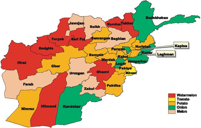
There is steppe and tundra the Hindukush mountain range. And somehow all that "desert" doubles as an agricultural area growing melons(!), other fruit, tomato, potato, onion and wheat. The north eastern forests of cedar, pine and oak host timber production growing in the mountains. If the photographs, maps and a little bit of serious internet research still can't show people the diversity in the landscape (IRL, at least), and the Registan desert is all that defines the country for some, I can't help it. Ultimately the basic mantra for all purchases apply. Don't like the product? Don't complain, that a company is producing something you personally don't like, simply don't buy it.

-
Yeah, sorry, wrong quote. The Hindukush is extending through nearly all Afghanistan, and the peaks to the west still rise to 3,000 m to 4,000 m, near central Afghanistan to 5,000 m. It's quite mountainous. The extreme high peaks are near the Pakistani border, but that doesn't make the rest of the Hindukush mountain range some hills.
-
Forget it, your right... Afghanistan only really consists of Kunar, Nuristan, Tangi valley and Kabul. All else is flat and boring.
-
There are to products on pre-order sale in the Store: DCS: Southwest Afghanistan for about $23 discounted DCS: Afghanistan for about $50 discounted. The second is the complete map (in EA only the detailed part). If you bought the DCS: Southwest Afghanistan you will need to purchase East and North separately... Adding up to more than $50.
-
Actually the Hindukush stretches through most of central Afghanistan including the southwest. Not the 7000m peaks, but 3000-4000m high mountains that are still challenging to cross in weather, nonetheless.
-
Did you make sure you bought the whole map? Or accidentally just the Southwest part? Just saying as I had a very close call and luckily noticed in the shop when scrolling down...
-
You start in the eastern area of the map part you bought (say KAF, Kandahar) fly south and everything is fine, now the server you joined spawns an action 20 NM east in the detailed area west of Kabul, that you don't own. If you fly in a group you can now disconnect and leave the server, or try to support your lead/wingman and pray you can identify what he sees... As in a MP environment you don't necessarily know beforehand where enemies or targets will present themselves. So you better buy the complete map anyway. I mean, i get the idea to have an option to safe discspace, or buying peacemeal, but the reality is, it does make a lot of sense to get the whole map for less than $50 instead of paying 3 x $23 = $69 or more, but that requires to scroll and read through 3 paragraphs, where it should be the first option / message in bold and red. Would have prevented a lot of drama.