graveyard4DCS
-
Posts
162 -
Joined
-
Last visited
4 Followers

Recent Profile Visitors
2133 profile views

-

Kola - 1:1.000.000 ONC map for CombatFlite
graveyard4DCS replied to graveyard4DCS's topic in Orbx Simulation Systems
Hi, Following the recent Kola theater update, the new airports have been added to the .xml file for CombatFlite. You can find it here. Good planning!
-
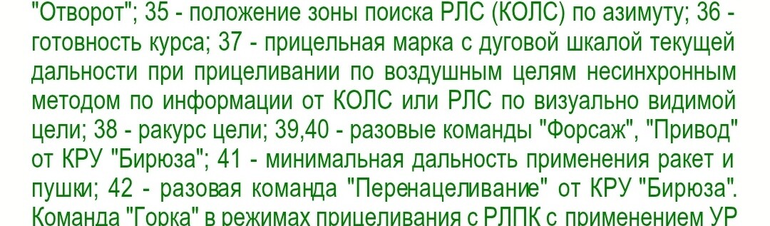
I explain it here: it originally designated FPS family ground early warning radars.
-
This is where I took the Привод explanation (39/40). And I agree, there's no T... Did I miss something in the translation?
-
Thanks for the feedback. For the SPO-15, I based the explanations on the historical origins of each symbol. I'm aware that the practical classification differs from the original terms, but I'll do it in a second time.
-
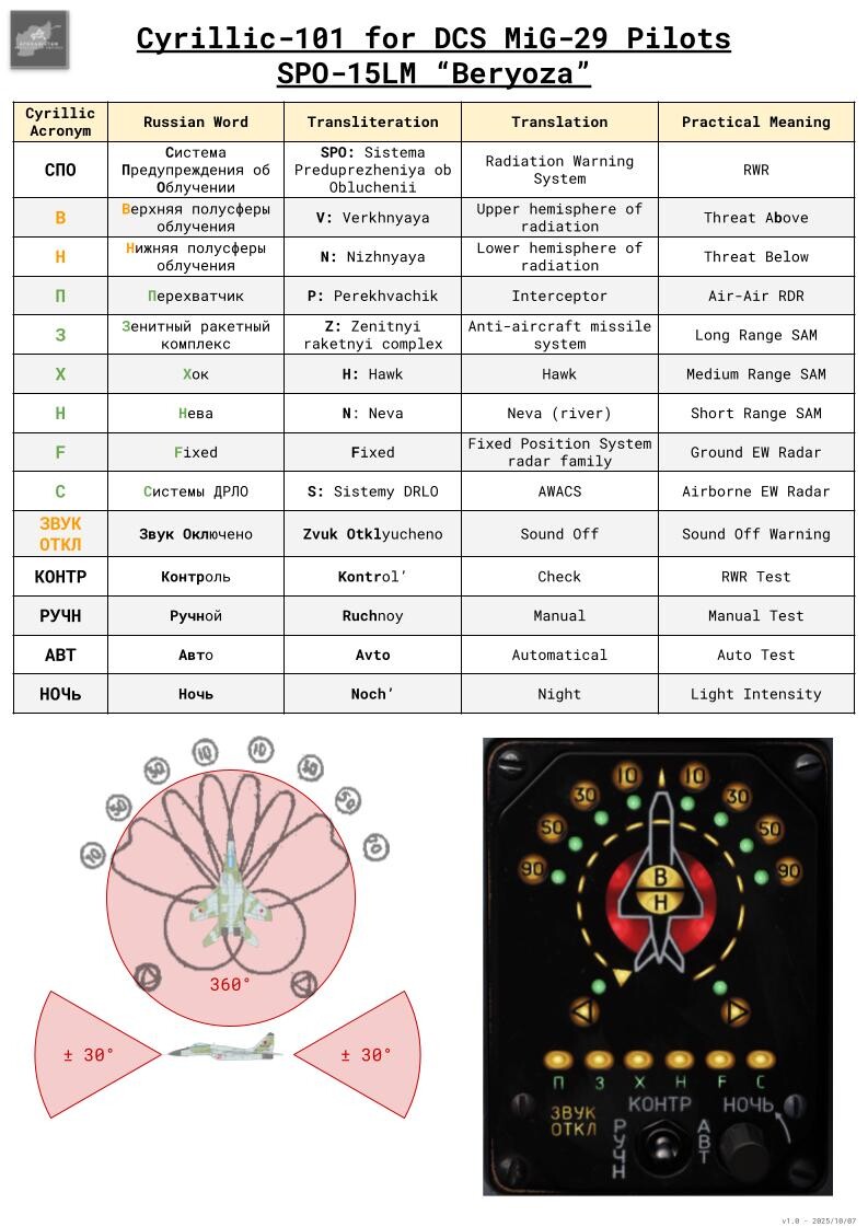
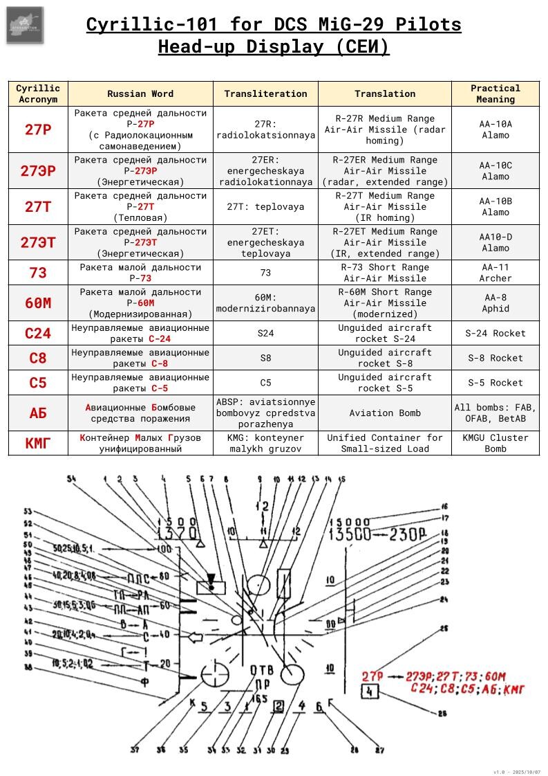
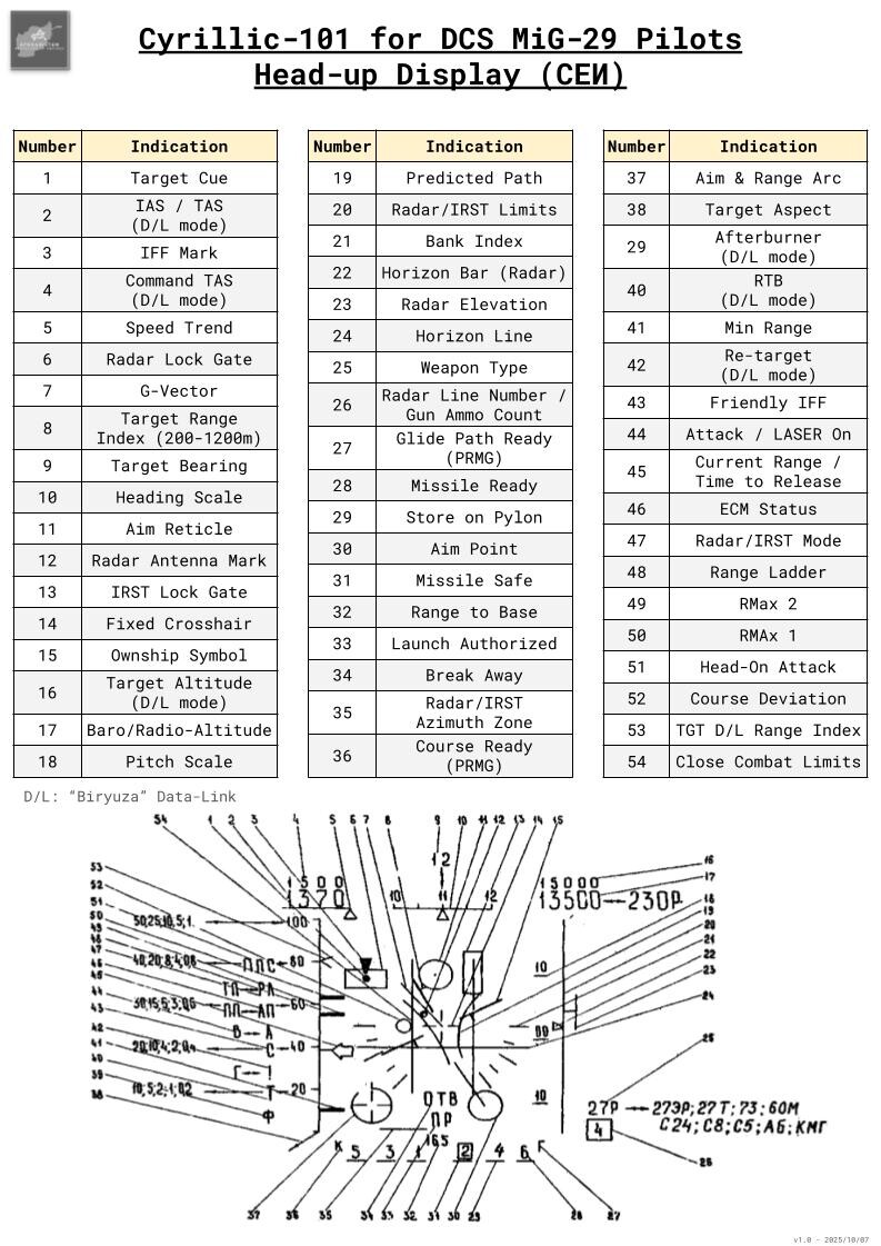
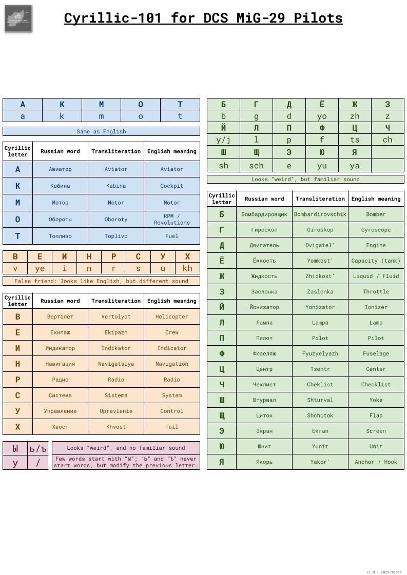
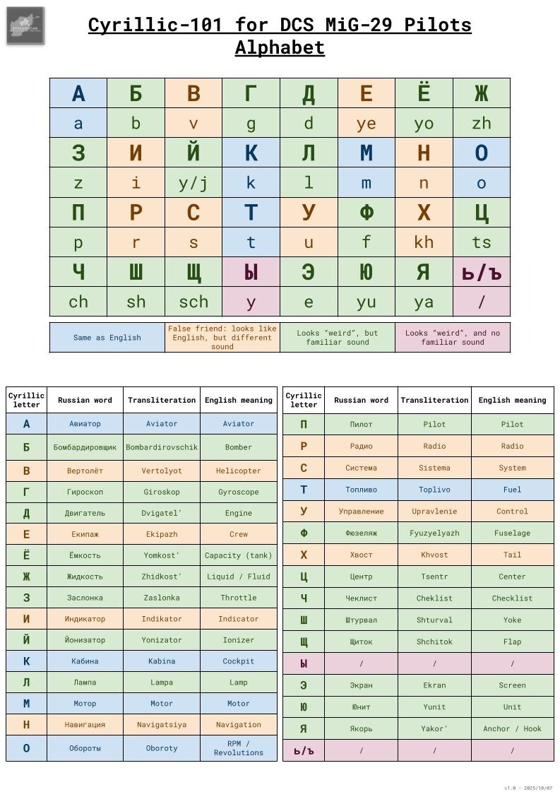
For those interested with Russian cockpit in the MiG-29, I created these references. I tried to discuss the meaning of each symbol more in details in these articles about the HUD and the SPO-15LM. For those who start from scratch, I even tried to make a short intro to Cyrillic alphabet. I'd be more than happy if any Russian native speaker were willing to check them! Thanks
-
Overhead Break: Are We (Once Again) Doing it Wrong?
graveyard4DCS replied to graveyard4DCS's topic in Chit-Chat
Yes. I made the mistake to think that people are willing to read, think by themselves and argue later. But I was mistaken. They tend to come with arguments of authority only. I will keep it in mind... -
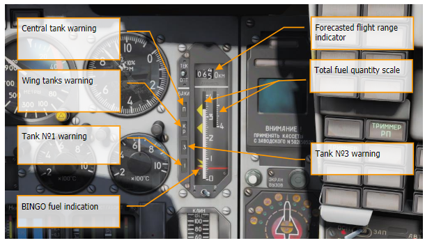
You have a KР indication on the fuel pannel, for "Концевой Расход". It's a kind of Bingo indicator. It's not supposed to be indicated on the HUD for 9-12 version, but maybe that's a beginning of explanation?
-
Overhead Break: Are We (Once Again) Doing it Wrong?
graveyard4DCS replied to graveyard4DCS's topic in Chit-Chat
True, this same technique applies to "short landings", and is similar to the night landing technique when assessing height is difficult. For most aircraft, the main landing gear can sustain the Vz of a standard 3° slope impact without flare (at normal weight). -
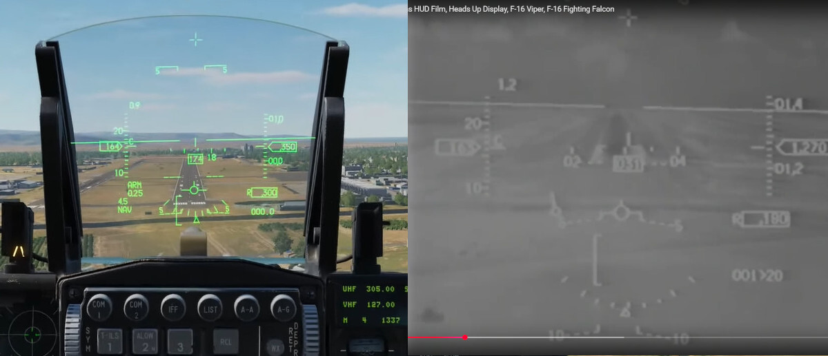
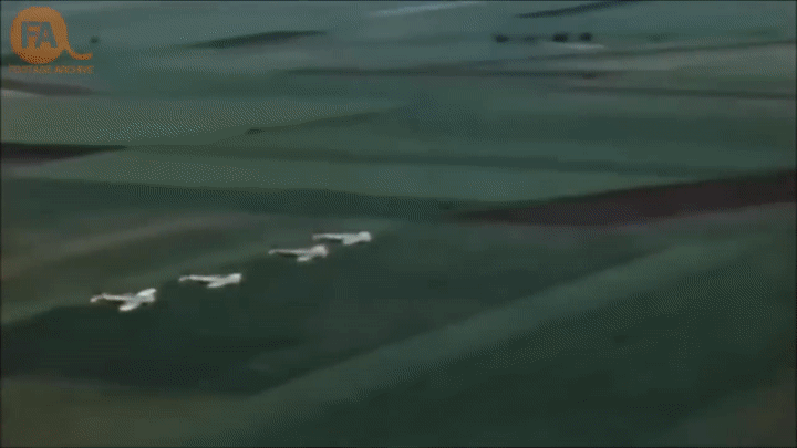
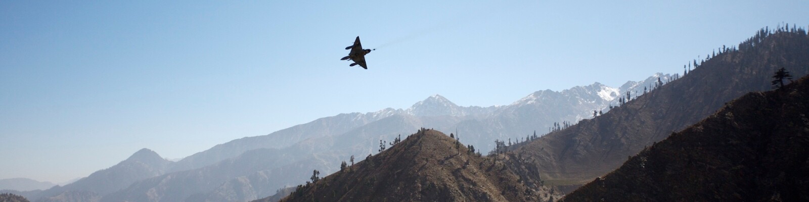
Overhead Break: Are We (Once Again) Doing it Wrong? After watching the recent MiG-29 landing tutorials, and remembering the debates that followed the earlier F-16 overhead break video, I thought it’s worth revisiting the overhead break (OHB) from a different perspective. The point is not just HOW to fly it, but WHY it was designed that way in the first place. Without that context, it’s easy to miss the purpose of the maneuver and fall into the same recurring mistakes we see in most DCS tutorials. TAC ATTACK - 1977: the "break" arrival has been designed to avoid the kills in the traffic pattern... As with the previous posts Runway Attacks in DCS World: Is (Almost) Everyone Doing It Wrong ??? and Flying Formations in DCS: Are We (Also) Doing It Wrong?, this is not about calling out individuals. We'll just treat visible mistakes as a learning opportunity, that's the basis of any serious debrief. What matters is understanding the tactical logic behind the OHB, and how to translate that into the sim with the right mindset. Below is a short list of the common errors that keep recurring in tutorial videos: Approaching slow, instead of keeping combat speed until the break Flying directly over the runway centerline instead of offsetting to the cold side Gentle 3G (and even less than 2G sometimes...) breaks that don’t place you properly abeam Eyes glued to the HUD instead of scanning outside Using the “45° cue” regardless of spacing, leading to huge base legs Flat final turns instead of rolling aggressively nose-low Touching down one-third into the runway like a civilian airliner instead of maximizing runway length Dropping the nose immediately on touchdown instead of using aerodynamic braking (unless chute-equipped, or not recommended for the aircraft type) Tutorial vs Reality... But the important is WHY such a difference? Missing the reasons for these errors defeats the whole point of the OHB: recover fast, safely, and tactically. I’ve tried to unpacked all of these points in a single article: combat origins, common mistakes, and practical guidance for executing the OHB properly in DCS. If you want to fly it like a real pylot, give it a read! Combat origins of the "Tactical" or "Battle" Break
- 6 replies
-
- 2
-

-
- overhead break
- overhead pattern
- (and 1 more)
-
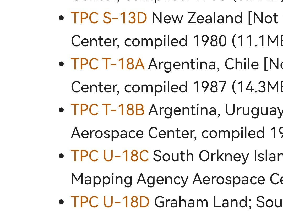
Thanks for the links, I already knew this website, it's indeed a very good source for all sorts of maps. Unfortunately, unless I'm missing something, it seems that they don't have T-18D. But still, thanks for taking the time to answer here!
-
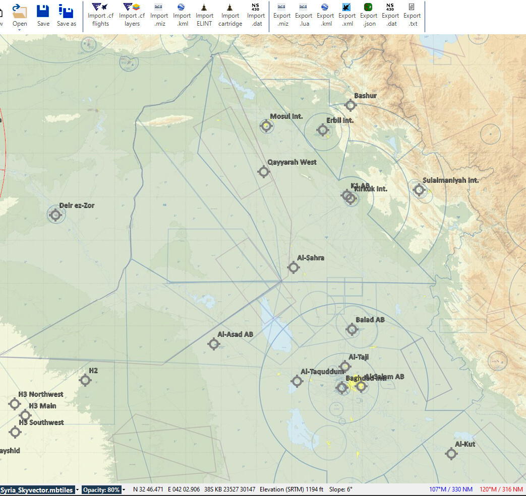
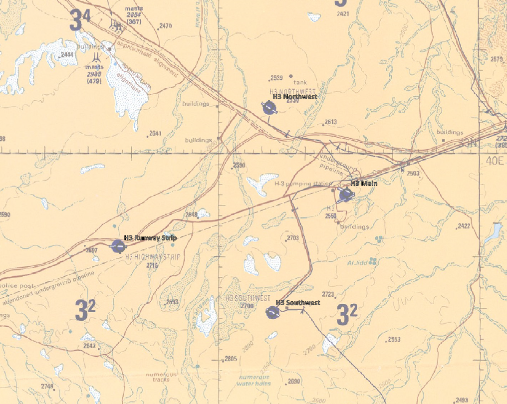
Following the latest DCS theater update, the CombatFlite database has also been updated. H3 Airfields Cluster Overview of current airfields for Iraq theater
-
Paveway II: Tactical Employment Series
graveyard4DCS replied to graveyard4DCS's topic in Guides & Tutorials
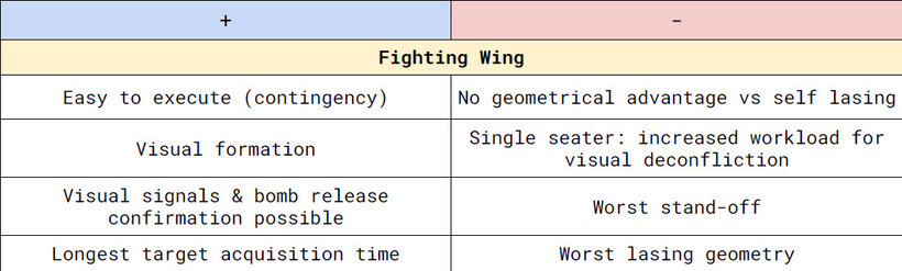
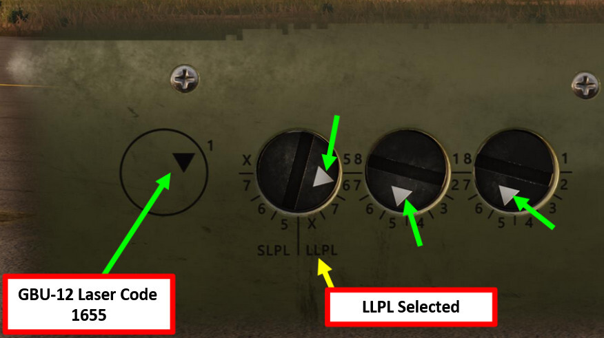
Phraseology, ground lasing and medium/high altitude buddy lasing have now been covered. The phraseology details the two possible lasing options: continuous (highly recommended in most cases, and I explain you why) and delayed. The ground-lasing section describes the profiles you’ll see when a JTAC is designating the target, highlights the main risks, and explains why Paveway II/III use modes such as Wide Pulse and Narrow Pulse, as well as the LLPL and SLPL options on the F-15E. Finally, the airborne buddy lasing series reviews the primary profiles: fighting wing, wedge, trail, and two circling methods. It and includes a short "tactical balance" for each profile to help you select the best option for your mission. SLPL and LLPL options on the LASER code for the F-15E Buddy-lasing Phraseology Tactical Balance of the "Fighting Wing" buddy-lasing profile.
-
Training Mission - Kandahar Firing Ranges
graveyard4DCS replied to graveyard4DCS's topic in Missions and Campaigns
The Kandahar Firing Ranges training mission has been updated in user files: added Texas Helo Range for rotary wings; removed High Digit SAM mod, the mission is now mod-free. More details about Tarnak Range here, and Texas Helo Range there (external links). -
Hi, Fist of all, thanks for these nice additions to the default map. Is it possible to have an idea of the future locations that will be added? That's in order to avoid duplicating efforts, since as you can see in user files, all the member's static templates try to recreated similar layouts with existing static objects. Also, there' a discrepancy between real name and what what's on the game map for COP Deysie that appears as FOB Daysie in game (it's actually a COP as announced and there's a spelling mistake). Thank you
- 1 reply
-
- 1
-
-
Taking the Risk Estimate Distances from official docs like the JFIRE is certainly the best way to answer your question. 10% PI and 0,1% PI were the two common thresholds in the past. You'll see that later versions use new references with 0.1% PI standing/prone/prone protected. You'll note also that values changed along time, taking into account newer studies and operational experience. In any case, it will give you realistic values for all types of western weapons effects.