

Ramsay
-
Posts
3744 -
Joined
-
Last visited
Content Type
Profiles
Forums
Events
Posts posted by Ramsay
-
-
The fuel gauge (0 - 3200 lb) is between the boost and fuel cutoff buttons (LH side, below the parking brake) and shows fuel remaining.
The fuel flow meter (0-2400 pph, right of the N1 RPM gauge) also has a 'Fuel Used' counter, that's useful if, for example, you have external wing tanks and want to know how much you've used, i.e. when you'll start to consume your internal fuel.
Note: I don't own the Aviojet C-101CC but the gauges look to be working correctly on youtube.
-
As an aside, can anyone explain how waypoint offset is supposed to work in the IRL plane (WOF).
RL examples would be entering the target as an offset of the IP waypoint, if the target was at a different altitude to the waypoint or a TACAN offset for it's IAF (initial approach fix) / holding point.
-
I tried to search the Youtube, but nobody has really bothered making one simple tutorial that shows the essential and the benefit of the whole thing.
I found this video pretty good - though it's not a tutorial as such.
-
• Folder Location > DCS World\Run.exe
you may also want to create\change the shortcuts for the updater
• Folder Location > DCS World\bin\DCS_updater.exe
-
Haha. You're welcome, since I'm the one who figured it out.
Sorry I must have missed your post where you looked at Peaches .trk and .acmi files and did the independent testing.
Your input was useful and if you'd tested and comeback with a post saying "yes, it's because ..." you could claim credit, as it is - you came back saying "which are you using ?" i.e. a question.
However, as I'm feeling generous, I'll give you joint accreditation for finding a bug in DCS :lol:
-
Is there any mission to Caucasus map too?
Yes, as that is the default map everyone has.
Obviously, if you buy a 'Red Flag' campaign set in Nevada - it's missions need the Nevada map to be playable.
-
You need to lift the "Lasing Button Cover (1)" and use the "Lasing Button (2)" - neither have a default keybind but you can assign a joystick/throttle button of your own.
Page 41 of the DCS SA342M Flight Manual

Pages 78-79 of Chuck's SA-342M Gazelle Guide
https://drive.google.com/file/d/0B-uSpZROuEd3ZDJBTEVpY1ZQRlU/view
-
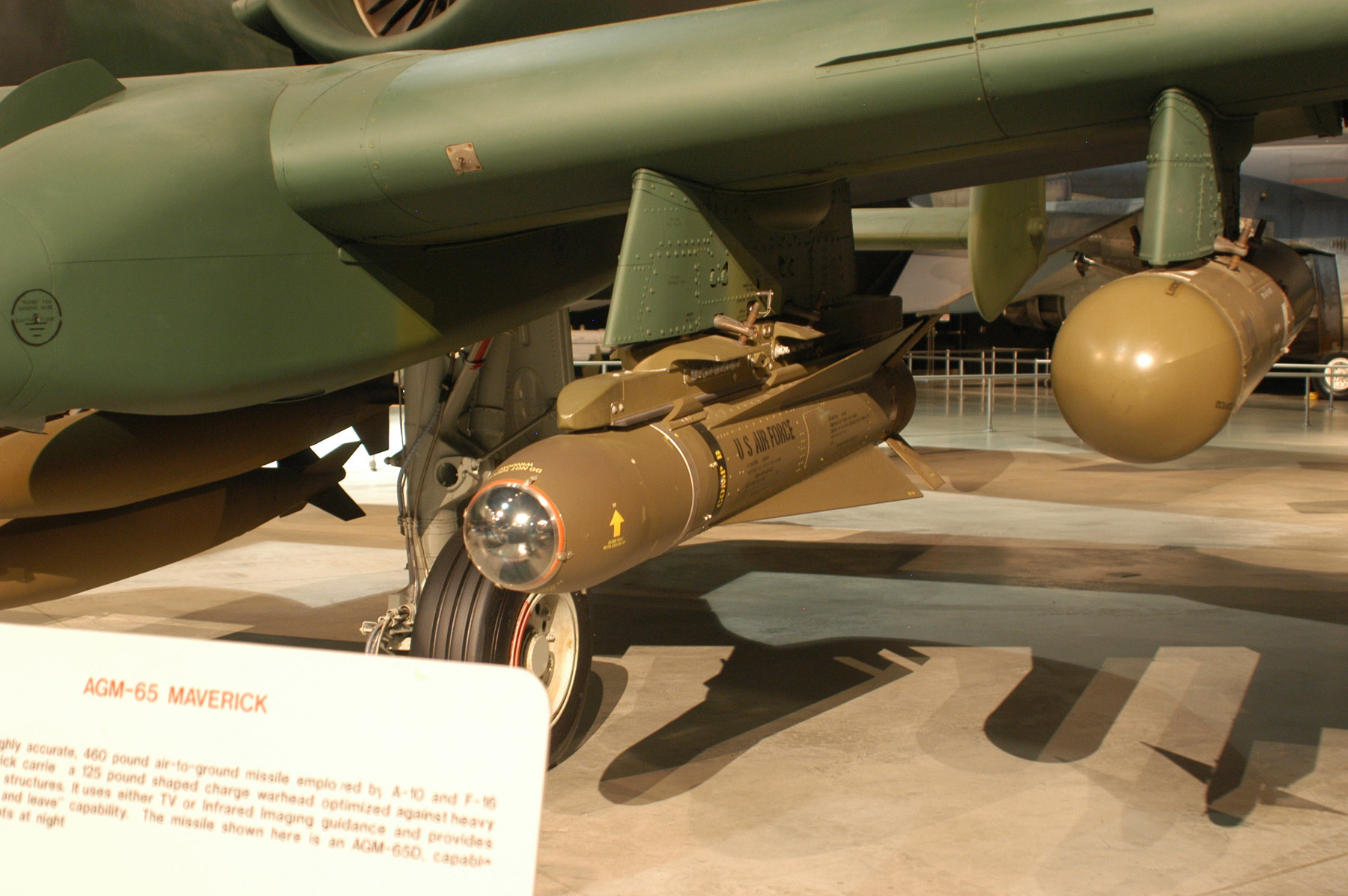
BRU-42 which is the rack used to mount the Mavericks adds a considerable amount of mass to the aircraft, and drag as well, the drag index is very high, especially when you mount all three Mavericks on it.
The triple mount for Mavericks is the LAU-88 (BRU-42 is a triple bomb mount).
The A-10A Non-nuclear weapons manual says of the LAU-88:
• On ferry missions a maximum of three missiles per TER can be loaded.
• On tactical missions a maximum of two missiles per TER can be loaded on a LAU-88
• The AGM-65G cannot be used on multiple rail launchers due to missile weight constraints.
-
Maybe they don't realise what a gem this could be with a little more love.
Agreed, I'd by a second copy for training and formation work - if the ADF needle was working/animated.
-
The Maverick should follow a high top-attack trajectory, by IIRC it is given roll-information from the aircraft prior to launch.
On the LAU-88, the side mounted missiles 'guidance and control section' (GCS) is adjusted to be properly oriented (arrow on either side the GCS up), the latest DCS FM update doesn't model that.
LAU-117
LAU-88
-
can anyone explain why this is happening?
It's the side mounted Mavericks on the triple rail LAU-88, they try to loft when launched but instead veer to the left or right depending on which side they were mounted.
https://forums.eagle.ru/showpost.php?p=3775989&postcount=8
-
When I fly the Mirage, the Hornet, the Su27, the Viggen or the FW190, it feels like sitting really in that plane and nearly feel what it will do next...
But maybe I'm all wrong about my feeling on the FM of the Harrier when you all say its fine.
With the Harrier you sit on 4 columns of hot and cold air with reaction air jets blasting out of the nose, tail and wing tips - the question is not if it flies like a Mirage or Hornet but if it flies like a Harrier.
I find the flight model believable and it hits most of the IRL performance figures.
-
What are the advantages or disadvantages of either one or are there situations where I would prefer one pattern over the other?
The long (600m AGL) approach is typical of an instrument approach or where you need to fit in with other traffic.
The short (200m) approach is typical of a visual pattern, however it's very low to my taste and I'd only fly it to avoid low cloud cover, etc.
As we don't need to take other traffic into account - I fly a visual pattern, descending in the base turn to pass over the outer marker at 150-200m (500ft) @ 250 km/h (135 KIAS).
Approach and LandingInitial: 250 KIAS / 1,500 ft AGL (450 km/h, 500m)
Break: Throttle 70%, Speedbrakes as Req'ed
Speed: Decrease to traffic pattern 190 KIAS (350 km/h)
Downwind:
Gear - DOWN below Max 180 KIAS (330 km/h)
Speedbrakes - Retract if extended
Flaps Dn (half) - TAKEOFF below 160 KIAS (300km/h)
Throttle 95-100% - As Req'ed to maintain 150 KIAS (280km/h)
Base/Final Turn:
Flaps Dn (full) - LANDING
Throttle - As Req'ed to maintain 135-140 KIAS (250-260km/h)
Final:
135 KIAS (250 km/h), 500ft (150m)
(+10 KIAS for half flap/crosswind, +15 KIAS with full drop tanks)
Landing Light as Req'ed
(Throttle 70% min recommeded for abort/go around, 9-12s idle response lag)
Reducing to:
Threshold speed 120 KIAS (220 km/h)
Touchdown speed 95-100 KIAS (185-200 km/h)
While training, you should follow Kursant's "local instructions".
-
There is an initial altitude you join a traffic pattern (perhaps +500ft) and the pattern altitude itself. Exact altitude/height depends on the terrain, etc. and local instructions.
Typical pattern altitudes for piston aircraft are:
... traffic pattern altitudes for propeller-driven aircraft generally extend from 600 feet to as high as 1,500 feet above the groundso 200m (650 ft) AGL is within that margin, AFAIK 300m (1000 ft) AGL is recommended for piston aircraft, with a jets at perhaps 500-600m (1,500 ft) ("Cat. C" depends on approach speed).
If Kursant's training is based off a real syllabus - it's possible, the lower pattern altitude is to avoid conflicting with a 'jet' lane i.e. breaking a 300m ATC ceiling, etc. but there numerous factors IRL, OTOH they may have used a pattern for piston aircraft.
The L-39 pattern altitude in DCS's manual reflects the manufactures recommendation (500-600m, 1500-2000ft, depending on the manual, imperial/metric, etc.). RSBN/PRGM's electronic glide slope is programmed to level-off at 500m.
-
SysRq is the unshifted state of the PrtScn button i.e. it's Print Screen without a modifier (Lshift, LCtrl, etc.)
-
If you have any question please feel free to ask.
Thanks, very useful (it's a long time since I played with the A-10C's snapviews), at least I can calibrate the world to the JHMCS cursor.
The snapview JHMCS 'calibration' does force placing the horizon on the monitor's centre line and so make one feel higher up than the default view.
OTOH it has the benefit that I don't struggle to look over the top of the canopy rail in dog fights (instead I fight with TIR to look at cockpit switches).
I'll need to fly more missions before I decide if the change is for the better but at least it's a workaround.
-
Shifting the JHMCS up to compensate for this is out of the question.
No it is not - as you say, it's done in other modules. There's also no reason DCS's zoom couldn't be shifted to the eyeline but a lot has to do with perception, when zoomed in close to a cockpit instrument or distant object - focus does shift to the centre, however with a typical view with a balance of horizon and cockpit in view, the natural focus is the horizon.
Once you zoom in it will slide off screen (like the HMD in the KA-50 does by default).Correct, however I'd prefer the JHMCS cursor to be where my eyes are looking at mid range and IRL, rather than when zoomed in.
Moving away from personal preference, etc., with a typical PC field of view (60-90° ?), I'd like the JHMCS cursor to reflect it's real position in 3D space as viewed by a pilot - not the centre position of a monitor where DCS view zooms.
If you position your view where you need it to be in game using trackir, and then hit alt+numpad0 it will save that as the default viewShifting the view so 2/3rds of the screen is cockpit when looking "eyes level" is not the answer, it just shifts the problem elsewhere - I'd be permanently tilting my head back at 7.5° real to look at the HUD, FPM and horizon (even when not using the JHMCS).
Hence why I choose to set TrackIR without considering the JHMCS cue.
-
I'm wondering what the distance limits are for this nav system or even if they are line-of-sight.
AFAIK, RSBN is a short range, UHF (1000 MHz), line-of-sight air navigation system.
I haven't checked DCS's range limits but a Russian source gives
• 500 km - the altitude of the aircraft 35 000 m;
• 380 km - the altitude of the aircraft 12 000 m;
• 250 km - at the height of the plane 5 000 m;
• 50 km - at the height of the plane of 250 m.
-
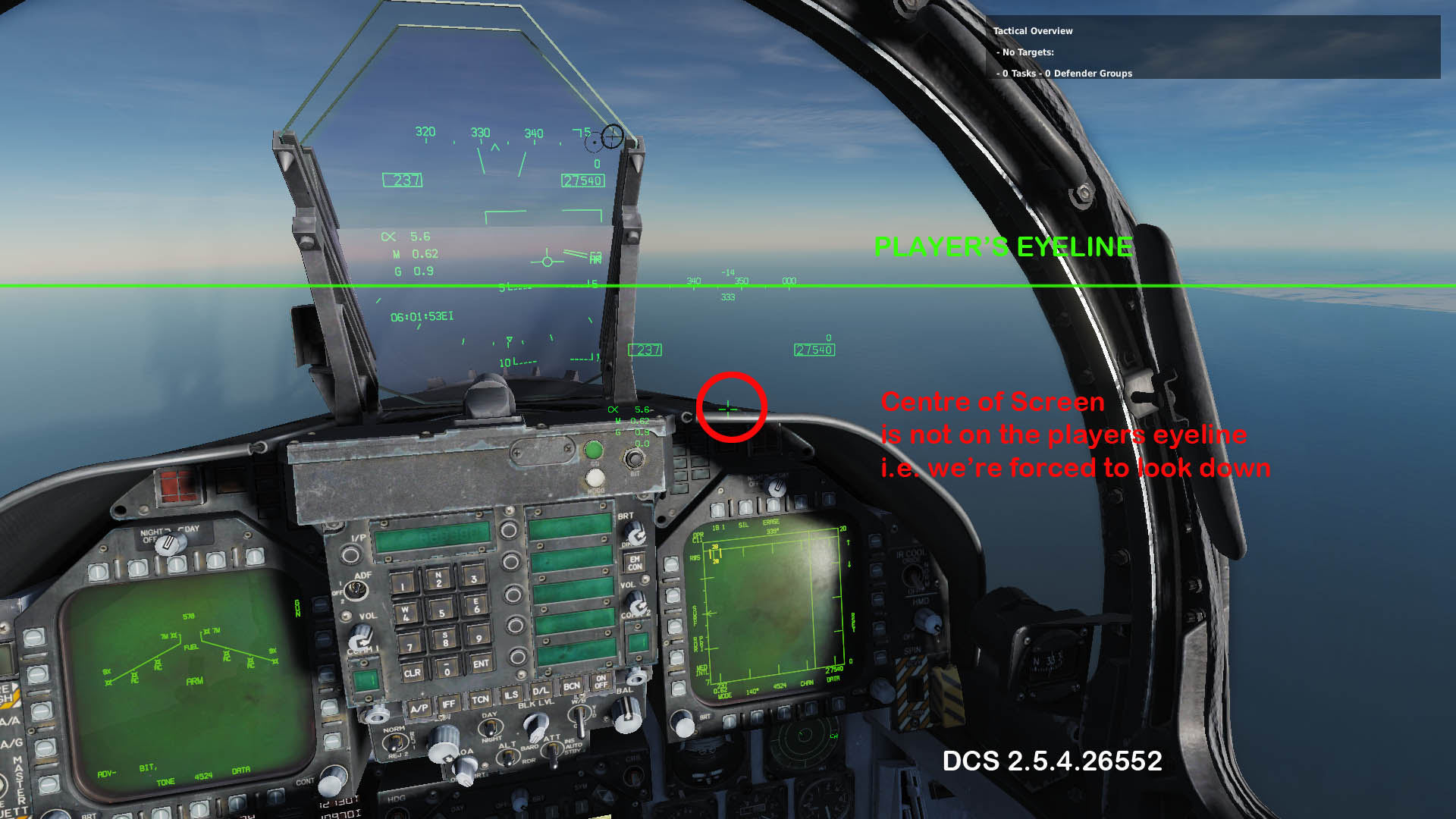
Why? Isn’t it more natural to look to the center of the screen?
Apparently not, even though my 100cm screen centre is level with my physical eyeline.
I imagine, whether it's problematic or not, will depend on individual setups and preference.
Do you really need to tilt your head down and look up?Yes, to put the JMHCS cursor near the horizon/eyeline, I tilt my head back 7.5° real for 13° in game according to TIR, though my setup isn't typical - a 100cm screen (40" LCD TV) at 60cm viewing distance.
-
JHMCS is drawn right in the center of the screen. Default view is turned down. This is why JHMCS seems to be misaligned. Aligning procedure won't help with this. I tested in VR and all what you need is to proper align your view.
The centre of the screen is not the same as the centre of the player's eyeline.
This screen shot was taken with track IR unplugged and the numpad used to slew the JHMCS to the side.
At a guess, I'd say we should use the 'rule of thirds' and place the JHMCS cursor 2/3 of the way up the screen, but a better way would be to allow players to adjust in game, either via a "DCS>Options>Special" drop down, checkbox, etc. or via simulating DDI/HUD JHMCS calibration.
Note: I'd expect VR JHMCS emulation to require a different cursor position, as VR visual perception is very different to viewing a 2D monitor.
-
 1
1
-
-
which one am i missing?
I'd guess
- PRES OXIG
-
The problem is, if the target is at a different altitude than the ground under your aircraft, then the slant range solution will be inaccurate (or you need to set QFE accordingly).
The F/A-18C Lot 20 and AV-8B moving maps include DTED (digital terrain elevation data).
AFAIK QFE should be set for MSL so the aircraft's own barometric altitude reference is with respect to MSL, IIRC another option is to use the GPS reference ellipsoid.
The AV-8B+ is flexible in which sensor/radar is used to calculate slant range, etc. I expect the F/A-18C is equally capable.
-
There is an error in the playback!
Looking forward to seeing it.
Here you go
[YOUTUBE]vgmU3naUqEQ
-
JHMCS doesn't need to align with the actual HUD. It needs to align with the aircraft. That's no something that you control. That's done by avionics technicians when they boresight and calibrate the system,
It's not about the HUD, it's about head position.
If I hold my head naturally and look at a target near the horizon, it's at eye level. As it passes to the side and out of the HUD, the JHMCS cursor (point of interest) is below it, such that I need to tilt my head back and look down my nose at it, so the aircraft sensors track it.
I can keep looking down my nose as it passes back and forth between HUD and JHMCS but it seems unnecessary and something that would be adjustable in the real aircraft.


on Steam soon?
in DCS: C-101 AvioJet
Posted
Great, now I just need to wait until the next Steam sale.