

Ramsay
-
Posts
3744 -
Joined
-
Last visited
Content Type
Profiles
Forums
Events
Posts posted by Ramsay
-
-
:cry: is there a keyboard layout for the Su-25T ? thanks in advance.
I used this crib sheet when starting out with the Su-25T,
09-23-2012, 11:34 AM #2159th_Falcon
Posted this a while ago somewhere else, hope it helps.
Additionally, when carrying the MPS-410 Jammer pods (need both)
you can use E to activate the jammers. (warm up time 15 secs i believe, once warmed up flashing green light in the RH console wall will burn steady)
Quote:
Originally Posted by 159th_Falcon
Needed for Start Up
===================
RSHIFT+L = Start APU (put electrical power on, whatever)
L = cockpit instrument lights (for when its dark obviously)
Ctrl + C = close/open canopy
Right Ctrl + L = Navigation lights (steady, alternating Left/Right, off)
Right Alt + Home = Start ENG #1
Right Ctrl + Home = Start ENG #2
Right Alt + L = taxi/landing lights (take's a while to move down from stowed position under the wingtip speed brakes
W = Wheel Brake
Needed for Take-off
===================
# (uk), \ (usa) = com's menu - "F1=Request Taxi, Request Takeoff"
1 = select navigation mode
F = Flaps (cycles between fully retracted and down one "notch" is for take-off)
G = Landing Gear (retract/extent)
Ctrl + ` = cycle waypoints, or cycle airfields when in Return/ILS mode nav mode
Shift + ` = previous waypoint/airfield
Needed for Flying
=================
Assign your axis!!!
` = AP override (is the key left of the 1 on your keyboard)
Alt + 1 = AP Attitude Hold (maintains bank and pitch angle)
Alt + 2 = AP Altitude and Roll Hold (maintains altitude and bank angle)
Alt + 3 = AP Transit Level Flight (panic button, returns aircraft to straight and level flight)
Alt + 4 = AP Barometric Altitude Hold (can still roll the aircraft)
Alt + 5 = AP Radio Altitude hold (can still roll the aircraft, follows terrain, Alt THERE ARE SLOPE LIMITS believe max 5 degrees up)
Alt + 9 = AP Disengage (disengage whatever autopilot mode was selected)
A = Auto Pilot on in selected NAV mode (meaning fly's to next waypoint, fly's to return point, fly's ILS approach, or when in Air to Ground mode and any targeting device lock it will fly to the locked target at the present altitude)
Rctrl + . = Trim UP
Rctrl + / = Trim Right Roll (right wingtip down)
Rctrl + ; = Trimp Down
Rctrl + , = Trim Left Roll (left wingtip down)
B = Air Brakes Extend
Ctrl + B = Air Brakes Retract
Needed for Landing
==================
F = Flaps (cycles between fully retracted and down one "notch" is for take-off, landing and manovur)
Shift + F = Flaps 2nd position (Full for landing)
Ctrl + F = Retract Flaps Fully
G = Landing Gear (retract/extent)
W = Wheel Brake
Needed for Air to Ground
========================
7 = select Air to ground mode
Shift + E = activate rear hemisphere IR jammer (should help against heat seaking missiles, don't expect magic though)
Space = Launch/fire selected weapon (gun/rockets/bombs/missiles)
Ctrl + V = Salvo Mode (launches selected weapon in salvo, for example 4 rocket pods at same time)
D = Cycle weapon stations
Right Ctrl + O = Mercury LLTV (low light version of Skhval, only if fitted)
C = Select Canon
i = Select Fantasmagoria (needed to lock and launch KH-25MPU and KH-58 Anti Radiation Missiles)
Insert = deploy chaff (only good against radar guided missiles)
Delete = deploy flares (only good against Heat Seaking missiles)
for both, DONT EXPECT MAGIC!
O = Uncage/Cage skhval
; = Skhval UP
/ = Skhval Right
. = Skhval Down
, = Skhval Left
(these also work for the ELINT and LLTV target designators)
Ctrl + W = Jettison Weapons (start whit A-G weapons, outter pylons first working inwards, then continues whit A-A weapons outter pylons first working inwards, pods/jammers can NOT BE JETTISONED)
Enter = Lock Target
Alt + R = Jettison External tanks (also in pairs, outboard stations first then inboard)
V = cycle ripple interval
Ctrl + Space = Ripple quantity
That's just about it i guess, you can download my profile here;
http://forums.eagle.ru/attachment.ph...9&d=1270665727
(both for SU33 and SU25T profile is bit dated so some things may not work anymore)
~S~
***EDIT***
Forgot the following
In options, controls, axis assignments look for I 251 zoom this is zoom of the Skhval and can be bound to a rotary/slider or other axis
Also look for "target box size, gun funnel size, gunpod elevation" this can also be bound to an axis.
=================================================
11-05-2012, 04:29 PM #2
PE_Tigar
On Su-25T brakes - toe pedals do not work by design, because on the real airplane the breaks are on a stick (a lever I guess, or a button). Differential braking is achieved by using rudder input+the brake command. Hope this helps.
Unfortunately I didn't make a note of the link to 159th_Falcon 's original post.
Apache600's Su-25T checklist is also an invaluable addition to your kneeboard (Saved Games\DCS\Kneeboard\Su-25T)
-
I understand how to use it, but for some reason it gives me climb rates that are not sustainable/illogical. I turned it on and initially had a climb rate of 9,000. I held that, then it decreased to 7,000 by the time I was stalling. Anyone else experience this?
Yes, doesn't look right, it'd be good to have a RL Hornet pilot confirm it's correct.
My best guess is it's showing the "Instantaneous Rate of Climb" (p80, Fig 11-28, FA-18ABCD Performance Charts, a1-f18ac-nfm-200)
Rather than "Climb/descent airspeed" as I would have expected from the FPAS description (p97-98, Fig 2-7, FA-18ABCD Hornet Flight Manual, F18-ABCD-000)
Climb Speed Schedule for DI=100 is 360 KCAS/0.81M (p67, fig 11-23, FA-18ABCD Performance Charts, a1-f18ac-nfm-200) and the DCS Hornet works well with that profile, matching the time and distance required to reach the optimum cruise altitude.
Tested DCS Open Beta 2.5.3.23954, GTW 41,462 lb (120C*4,9X*2,Fuel 330 gal), Persian Gulf
Note:
The F/A-18E/F Fight manual says it's FPAS 'Climb' button displays the optimum KCAS, so it looks like a bug (unless the the earlier F/A-18C is different).
When selected, CLIMB is boxed and the climb airspeed prompt indicates the desired calibrated airspeed for an optimum climb profile. -
Do you only ever play Blue ?
Try adding Ukraine or Georgia to Blue, then use a "Russian" EWR (assign a Hz & Call-sign).
It has the same menu as AWACS
Interesting, I've never been able to get the Georgian 1L13 EWR to work for the blue coalition.
It'll appear under the AWACS menu but radio coms never work. The problem seems related to western AWACS using identifying code words like "Overlord", etc. and Russian AWACS/EWR using digits "611", etc.
There's a work around that changes western AWACS/EWR ID's to use digits and allows the 1L13 EWR radio to work.
As Blue EWR's have been a long standing issue in DCS, I thought the bug was well known (even if not a priority ATM).
EWR Workaround, DCS 2.5.3 : https://forums.eagle.ru/showpost.php?p=3329693&postcount=37
-
Aries101 said:I wonder, maybe you know. Is there on youtube guide or at least video with L-39 ZA bombing approach, roll dive and all that goes with bombing.
I uploaded a rocket attack to youtube a while ago, the attack run
Dropping bombs, I use a similar profile, except that roll-in altitude, release altitude/speed, sight depression, etc. are different. There are tables in the DCS L-39 Manual and Chuck's L-39 Guide but I've never been very accurate.
IIRC the idea is to roll-in wing level, get stable and hit the release altitude/speed 6 seconds later (-350m altitude).
There's a neat trick where, with infinite ammo, you use active pause at the point of release and then drop bombs - they'll fly off the rail so you can see where they land compared to the piper. You then adjust the piper and/or try to hit the same parameters.
I did this description for a CCIP attack using the F/A-18C, it uses the same ideas but obviously, it's much easier having a CCIP sight, rather than trying to hit the correct parameters for dive angle, altitude and speed at release.

-
 1
1
-
-
As someone new to DCS and the A10C, I didn't know that the DCS A10C's engines were underpowered vs. reality. That explains a lot! It didn't seem right. Cruising speed of 300kts? I wish, only in a dive!
While the engines do seem a little under powered, it's not as bad as you may think.
Cruising @ 31,000 ft, M 0.52 = 180 KIAS = 300 KTAS
Your TAS can be found on the CDU position page and then using RLSK 1 to toggle between IAS/TAS/GS
Tested using a 'clean' A-10C, Persian Gulf map, DCS Open Beta 2.5.3.23788
-
When I pull up the MAV 65E laser format page I only have one maverick listed under laser codes.
It's a bug, the 4 codes are superimposed on the same line, rather than listed on different lines of the DDI.
Tested DCS Open Beta 2.5.3.23788
-
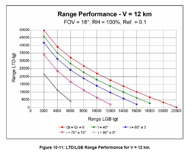
Is it even possible to illuminate a target more than ~8nm away? In clear daylight weather?
Yes, 8 nm (14 km) max range is a reasonable approximation for self designation in good conditions.
If the laser designator is closer, the laser spot can be detected from further away.
Conversely, if the illuminating laser is further away, the weapon needs to be launched closer.
IMHO Angle of incidence and meteorological visibility (14 km -> 4 km) are more important RL factors that reduce the effective range.
This chart is for the 'best case' but gives the general shape of all the curves and how angle of incidence effects detection.
Note: The AV-8 Tactical Manual Vol 1 (A1-AV8BB-TAC-000) has a detailed description of the AGM-65E's ranges - it''s 30°/20nm Visibility chart is close to the above green curve with a max acquisition range of 9.75 nm (18 km).
I'd say the DCS LMAV seeker over performs as it can acquire targets at 16 nm (30 km), while the real max acquisition range is around 12 nm (22 km).
-
Same here, either by HOTAS binding or default key "C".
LMAV cage/uncage is bugged at the moment unless the loadout was configured in the Mission Editor i.e. it works for a airspawn or a cold start that doesn't require calling the ground crew for rearm/refuel.
Tested DCS Open Beta 2.5.3.23788
I have a mission with 2 cold start Hornets, one with Mk-83's, one with AGM-65E's. If I use the AGM-65E Hornet, Cage/uncage works, if I take the Mk-83 Hornet and change it's loadout to AGM-65E's, everything works until it's time to uncage the laser seeker.
-
I preferred an accurate, flexible, contemporary South Atlantic map - so I'm glad Mount Pleasant will be part of the standard map.
Hopefully it'll be suitable for coin op's and what if scenarios where Argentina takes and reinforces the islands before a British task force arrives, a conflict over oil/fishing grounds, etc., etc.
No doubt I'll recreate some missions from Peter Squire's 'The Harrier Goes to War' that describes the 1982 conflict in detail and I'll leave Mount Pleasant unmanned/underutilised for those but I don't foresee any major issue, other than the need to substitute/limit existing flyable aircraft/weapons for missing 1982 DCS assets.
Note / Question :
I do struggle to understand the opposing view or why some want a 'hard baked' South Atlantic map set in 1982, while at the same time fighting faux conflicts in 2011 Caucasus and/or Persian Gulf settings.
Perhaps someone can explain what a 1982 period accurate map brings and why Razbam should ignore the wishes of 75% of the people who replied to the poll.
-
In the saved Games folder under liveries I have a folder
f_a-18c in there are a bunch of skins, which I guess were installed by default, as I use OVGME for my skins right now.
...
I just wondered if others had the same and if anybody knew more about what these skins are about?
You have some none standard skins installed for the 'old' AI Hornet, hence the livery folder name "f_a-18c"
Skins for the flyable "F/A-18C Lot 20" would be placed in a "FA-18C_hornet" folder.
There are substantial differences between the old and new hornet models including changes in texture names, etc. - hence why placing textures for the old model in the 'lot 20' folder, doesn't work.
-
What am I doing wrong?
In the TACAN 'Advanced (Waypoint Action)' dialog where it says 'UNIT=NOTHING', you need to select the Stennis from the drop down list - in your case you'd select "Unit #001" (as that is the name of your Stennis).
The same will be true for the ICLS dialog.
Re: your other questions, I'd really need to see a video or track to see what you're doing or not doing during your startup.
Perhaps try a hot start or auto start to confirm it's not something in the mission.
-
Well I wait for ideas some time and then off to devs...this plane was not cheap to do that .
Looking at "VP Ground attack practice mission 1 def.miz" and reading it's 'options' file :
The difficulty section has
• ["easyFlight"] = true
meaning it was saved with Options>Gameplay>Game Flight Mode 'enabled'
This is likely the cause of your problems and why behaviour was different when your friend hosted a mission.
• If you disable the 'Game Flight Mode' and resave the mission, you'll probably fix your issue.
'Options' file difficulty section for reference.
["difficulty"] = { ["padlock"] = true, ["geffect"] = "realistic", ["easyRadar"] = false, ["cockpitStatusBarAllowed"] = false, ["miniHUD"] = false, ["permitCrash"] = true, ["birds"] = 0, ["optionsView"] = "optview_all", ["setGlobal"] = true, ["immortal"] = false, ["avionicsLanguage"] = "english", ["cockpitVisualRM"] = false, ["map"] = true, ["reports"] = true, ["hideStick"] = false, ["radio"] = false, [color="Red"]["easyFlight"] = true,[/color] ["tips"] = true, ["spectatorExternalViews"] = true, ["userMarks"] = true, ["units"] = "metric", ["userSnapView"] = true, ["RBDAI"] = true, ["externalViews"] = true, ["iconsTheme"] = "nato", ["fuel"] = false, ["weapons"] = false, ["easyCommunication"] = true, ["labels"] = true, }, -- end of ["difficulty"] -
Anyone has similar experience? Maybe it is a matter of setup but I can't find it.
Same, the moving map appears misaligned (perhaps by Mag Var ?), doesn't look to be a priority ATM as it's been this way since release and there's been no dev feedback since last year (though I'd guess it's on a todo list somewhere ?).
https://forums.eagle.ru/showpost.php?p=3618263&postcount=8
Same report was in russian thread. Definitely - bug. Reported. -
Can I purchase plane on Steam and then activate it in DCS 2.5?
Yes, if it's an older module.
Older DLC's/modules bought via Steam (i.e. A-10C) with a Steam description that includes "Incorporates 3rd-party DRM: Starforce ProActive" have a 'key' that can be registered to your DCS profile/account and activated in the 'standalone', as well as on Steam.
I ask because on DCS website there is inscription "STEAM Incompatible".There was a change in Steam policy and DCS copy protection a while ago (May 2017) that mean newer modules (i.e. Hornet) bought on Steam can't be activated in the standalone version and E-shop keys can't be imported to Steam (hence "STEAM Incompatible").
DCS Steam and DCS standalone are usually on the same version number, so the multiplayer community isn't split but once you have bought a couple of the 'newer' modules, you are effectively 'locked' into buying from only one 'store' and using one version.
-
The course heading 260°M looks wrong, if landing at Kutaisi RWY 26.
• Kutaisi RWY 26 measures 254°T using the F10 ruler.
• Caucasus MV = 6° E
So ...
• RWY 26 magnetic heading = 254°T - 6° magnetic variation = 248°M
and 248°M is the course setting required for the A-10C HSI
Note: There will a be small difference in the ground track to 248°M as the TACAN station is offset to the side of the runway,
-
4. Does my approach make sense or would anyone offer different advice to get started?
I'd start off with the free Su-25T, as it covers the basics and lets you learn DCS's strengths and weaknesses without any initial expense.
If you are considering the YAK-52, the TF-52D Mustang might be a better alternative for similar reasons and it makes a good aerobatic trainer. P-51D youtube videos and Chuck's guide work well for the TF-52D.
Once you've learn't/refreshed the basics in the Su-25T/TF-52D - then it's time to choose, your first module.
The L-39 is an excellent module (I have lots of hours in it due to MP coop training) but like the YAK-52 it has a limited set of default missions, so being prepared to create your own goals and challenges using the mission editor is a must IMHO.
When finally picking a 'full' module to learn, I'd pick an aircraft, ops and era that most interests you i.e. it's quite possible to start with the DCS Hornet and use CNATRA T-45 Goshawk training materials.
If your final goal is to fly the Hornet, I'd probably give the L-39 a miss and go straight to that, learning the individual systems one by one and setting intermediate training goals.
Due to the difficulty in spotting targets/enemies visually in DCS, aircraft that include Modern (4 bar) Radar, RWR, A2G Targeting pods, etc. work the best longevity/combat effectiveness.
For older or less capable aircraft like the L-39, there are work arounds like the CTLD script, that allows easy target marking with smoke, etc. but it's something to be aware of for WWII birds, etc. and is it's own challenge.
-
Mapview is a third party addon for Tacview developed by Jacques ‘Detox’ Deyrieux.
With just a few clicks you can now automatically download and install terrain tiles for your favorite theater of operation. Mapview will download terrain tiles from one of predefined providers. They are then processed and stored in Tacview custom folder C:\ProgramData\Tacview\Data\Terrain\Textures.
Mapview is a fantasic application, I can't say how many hours/days I spent copying and pasting Skyvector screenshots to make tiles for Tacview.
After generating a set of tiles for the Persian Gulf, I decided to generate a set for the Falklands Islands.
Unfortunately, the tiles for the Southern hemisphere were misaligned
I'm not sure which application is in error (Tacview 1.7.4 or Mapview 1.4.2) but thought to report so any issues can be fixed ahead of a "South Atlantic" map release.
-
The trim switch on the stick in game is moving properly and the right elevator is the only trim moving.
That is the correct behaviour. The right elevator tab is for 'regular' trim adjustments, the left tab is for automatic pitch compensation when moving from half to full flaps.
Note: Unfortunately when using a regular joystick like the TM HOTAS, the stick position doesn't change (due to aerodynamic forces) when changing from half to full flaps (unlike in the real plane or when using a FFB stick), so the compensation tab causes a pitch up in DCS, rather than compensate for a pitch down.
IMHO it's probably one of the few areas where DCS differs significantly from IRL L-39 behaviour unless using FFB.
-
Very nice explained! Is correction for PG map also -6 degrees?
The Persian Gulf Magnetic variation is 2° E
For example :
• I have a CVN-74 Stennis sailing a course of 90°T in the Persian Gulf map.
This is the heading in unit properties, mission planner/editor, measured by the F10 ruler, F9 ship view, etc.
• Persian Gulf MV = 2° E
So ...
• Base Recovery Course (BRC) = 90°T - 2° = 88°M
the landing deck is offset -9° to BRC, so ...
• Final Bearing (FB) = 88°M - 9° = 79°M
-
ATC will (should?) issue headings in magnetic.
Not AFAIK in DCS.
-
I hit F9 to go to shipcam and that gives me the carrier course. My question: Is that heading magnetic or true?
The F9 ship cam heading, is the same as the F10 ruler heading, so true.
For example:
• I have the CVN-74 Stennis sailing a course of 335°T in the Caucasus map.
This is the heading in unit properties, mission planner/editor, measured by the F10 ruler, F9 ship view, etc.
• Caucasus MV = 6° E
So ...
• Base Recovery Course (BRC) = 335° - 6° = 329°M
the landing deck is offset -9° to BRC, so ...
• Final Bearing (FB) = 329°M - 9° = 320°M
As Mule says :
... because the carrier is moving, and there will,be a wind blowing, the actual direction you will need to steer in your F-18, to stay lined up with the flight deck will be slightly different. If the carrier is steering into wind (which it should normally be doing),you will actually have to steer about a degree or two right of the FB-
1
-
-
Ramsay, you say that, for DCS, True North is the same as Grid North. Which Grid North? There are 2 Grids on the ME map - MGRS and (I presume) Geographic.
Neither Lat/Long or MGRS grids align with true north as measured in a DCS aircraft. True north for the Hornet is shown by the F10 ruler.
This is a diagram for the L-39 but should give you the idea :
-
One final point is that if you are measuring directions for the DCS maps, they will almost certainly NOT be aligned with True or Magnetic North.
Directions measured in DCS maps using the F10 ruler EQUAL true bearings as far as aircraft system modelling is concerned.
The direction a magnetic compass/HSI in the cockpit of a (full module) aircraft points = F10 map ruler - magnetic variation
An exception to this is FC3 aircraft like the F-15C, where the magnetic compass, HSI and HUD all equal the F10 ruler (due to FC3's simpler system modelling).
DCS's latitude and longitude grid is not aligned with true north (as measured in an aircraft), so in game is like the MGRS grid in IRL. Flying 0°T in the L-39, AV-8B or using the NS430 will not follow a line of longitude.
Because a map is a flat representation of a curved surface it will always have small discrepancies.While correct, most errors seem attributable due to rounding i.e. perhaps 120.99° gets truncated to 120°, rather than rounded to 121° and errors are cumulative (<=±2°)
There is another (in fact many other) north, which is based on the alignment of the map grid. This is Grid North - but let us not go there.The F10 map ruler (Grid North) is rather important though, it equals true north for aircraft systems and unit movement and is the BRA reference called out by ATC, AWACS, etc.
i.e. F10 ruler - Magnetic Variation = Magnetic heading
-
For magnetic declination correction in Nevada map, the KM-8 correction pointer must be moved to 0 for reliable heading indications (!! Another issue I guess).
Working as intended.
The RMI (HSI) displays true bearings, not magnetic (as found in most western aircraft). Which is why the default DCS setting of the KM-8 corrects for magnetic declination.
Note: RSBN stations are aligned with true north and their radials/bearings similarly aligned. TACAN/VOR are aligned with magnetic north.
With respect to Nevada, the L-39 is consistent with other modules.
Nellis AFB, RWY 03 (40°T)
L-39ZA
• RMI = 40°T = F10 map
• backup compass = 28°M = F10 map - 12° Magnetic Variation
A-10C
• HSI = 28°M
F-15C
• Magnetic compass, HSI and HUD = 40° = F10 map (due to FC3 modelling limitation)
AV-8B
• EHSD and HUD = 40°T or 28°M (depending on mode)
Note: A-10C CDU Magnetic Variation, 1 June 2011 = 12.3 E
Tested DCS Open Beta 2.5.3.23225

Tacview1_7_4.JPG.a42cfd811ce564a01e64df0ddf0ba88b.JPG)
[FIXED AS AIRSPEED] FPAS 'CLIMB' displays Climb Rate instead of KCAS
in Bugs and Problems
Posted · Edited by Ramsay
TL;DR:
Displaying climb rate when the 'FPAS CLIMB' button is boxed, doesn't look right, can you confirm the current implementation is correct ?
Detail:
It's described as the "Climb/descent airspeed" in Fig 2-7 of the RL Fight Manual (p97-98, Fig 2-7, FA-18ABCD Hornet Flight Manual, F18-ABCD-000) and the optimum climb profile table gives pilots airspeeds/altitudes to fly an optimum climb profile i.e. 360 KCAS / 0.81 Mach
My best guess is that DCS's FPAS 'CLIMB' button is showing the "Instantaneous Rate of Climb" (p80, Fig 11-28, FA-18ABCD Performance Charts, a1-f18ac-nfm-200).
However the climb rate doesn't appear to be sustainable at Military Trust and it's hard to see how 'rate of climb' is used to follow a descent profile.
The Climb Speed Schedule for DI=100 is 360 KCAS/0.81M (p67, fig 11-23, FA-18ABCD Performance Charts, a1-f18ac-nfm-200) and following the RL optimum climb profile, the DCS Hornet worked well, matching the time and distance required to reach the optimum cruise altitude.
Note:
The F/A-18E/F Fight manual is a little more descriptive than the F/A-18C's, specifically saying it's FPAS 'Climb' button displays the optimum KCAS for climb/descent, so it looks like a bug (unless the the earlier F/A-18C is different, however the F/A-18E/F HUD diagram and description is similar).
Tested DCS Open Beta 2.5.3.23954, GTW 41,462 lb (120C*4,9X*2,Fuel 330 gal), Persian Gulf