

Ramsay
-
Posts
3744 -
Joined
-
Last visited
Content Type
Profiles
Forums
Events
Posts posted by Ramsay
-
-
Any updates in the patch today?
English cockpit added yet?
The English cockpit textures now load when selected in "Options/Special/M-2000C" i.e. "mainpanel_init.lua" has been updated.
Tested DCS Open Beta 2.5.3.23225
-
I will give it a try.
Note: If the stopped convoy come under fire and disperse, the AI *may* ignore the stop order and move onto the next way point after the disperse 'cool down' (usually 10 minutes) i.e. cross the broken bridge/ford the river.
A work around is to set "Advanced (waypoint actions)" - Option "Disperse under fire = off" at the AI's spawn point.
-
I am trying to perfect my Mirage capabilities (A/G) but so far I suck.
lol, it's normal. The Mirage isn't optimised for A2G, in that respect it's a very 70's aircraft.
I guess bombing can be perfected by repetition and that is all fine (getting better there). problem arose when I started to practise on server. Now there I cant see where enemy units on ground are (lacking radar i guess)No, you are lacking GPS navigation and a targeting pod (long range IR TV). Only the Viggen can spot targets (ships) using it's radar.
my first question is: How the hell you see anything on ground, especially in late afternoon or evening?By inputting INS coordinates for the target area and visually, either by smoke marker (player or CTLD) or pre-planning recon/description of the target location i.e. 200 ft south of the white hangar.
I haven't had much success at altitude A2G (unless targets are marked and enemy AA is light) - so use the Mirage like a Viggen, for low level/high speed strikes dropping snakeyes (one pass, haul ass).
Primary objective is to drop bombs and RTB, secondary to get bombs on target.
Note: the HUD is about 7 pixels 'out', so waypoints/targets need to be marked/weapons released when the piper is slightly in front of their position.
Second question is for part when you need to GTFO there and I usually get hit by Tunguska (is is S3 system?) . As I then went to read a bit I realised that Mirage have missle detector as for radar missles so for IR ones if it can see heat signature. Also , does anyone knows how long is this system warming up ?So i guess second question is more like, plea for help and tips on how not to get shot down by ground based missles. :(
• Route planning for terrain masking/ SAM avoidance.
• Speed (>450 kcas) and altitude (< 500 ft) to limit the opportunity for SAM's to fire,
• Visual clues for target/SAM location.
• RWR, DDM and visual scanning for SA
• Counter measures before, during and after strike phase (to counter the IR missile you don't see).
• Speedy egress (don't re-attack)
At altitude - speed and SA are key, if a SAM on your RWR, locks/fires at you, assume you are about to be shot down and react 'immediately', don't try to assess who it's firing at until you are safe (unless you have visual on the smoke plume and can see it's been defeated).
Note: Moderate altitude (12,000 - 500 ft) and speed (< 350 kcas) will make you particularly vulnerable.
I meant I did my best with trying to see dots but I did not saw a thing.It's normal as targets are often difficult to spot unless moving (dust cloud).
It's quite possible to recreate
in the Mirage but as you'll note, the target vehicles are in in the open, so easy to spot.YMMV
-
Shouldn't the guy next to me also be reporting the same altitude when in say an f-15
No, FC3 aircraft have different system modelling, so just like their (magnetic) compasses read True bearings (F10 map), their altimeters are also simplified and won't match full modules that take more factors into account.
... or perhaps wouldn't the tanker also report an altitude for rejoin that isn't 2000 off of what I have indicated?IIRC the AI will fly to the height set in the mission editor, rather than standard ISO (760mmHg, 29.92inHg, 1013mb) or other settings.
So with OAT -12C and 30.22 inHg at sea level, your altimeter will read differently to the F10 map, if you use 'standard' pressure.
-
What date is the included navaids database in the NS430, and, is it possible to update it using, for instance, Navigraph service ( as used for FSX / P3D / X-Plane ) ?
Unlikely, as DCS (and therefore the NS430) runways, etc. don't align with the real world exactly i.e. in DCS Batumi RWY 13 is 126° True (120° Magnetic) while in real life it is approx 132° True (126° Magnetic).
The data the NS430 uses looks to be based off real world approach charts, etc. but has, out of necessity, been adjusted to fit DCS's maps, so you're not going to be able to 'plug-in' a real world/FSX update easily.
-
If you use this mod the Mig-21 RSBN stops working. So this mod is incompatible with the Fishbed.
Strange, the Fishbed doesn't use ED's Beacons.lua,
• "DCS World\Mods\terrains\Caucasus\Beacons.lua"
rather it uses it's own
• "DCS World\Mods\aircraft\MIG-21bis\Cockpit\Systems\R_NAV_data_Caucasus.lua"
Edit:
Sorry, user error. The Mig RSBN is working.Glad it's working.
-
how do I know how much reticle depression I need in manual ground modes? For the F-5E there are charts combining speed, altitude and pitch and give me the appropriate number for RetDepr. For the Hornet there´s no such charts... Any ideas?
Just guessing, but how about:
• performing a 'regular' CCIP attack
at the point of bomb release
• freeze DCS with 'active pause'
• note: cross position, dive angle, speed, altitude and 'aim-off' point
switch to manual bombing mode
• set depression to match the previous CCIP aim point
repeat with various heights, speeds, etc. and compare depression values to the F-5 table or similar.
Edit: Didn't really work (but I couldn't fly consistent parameters, so perhaps it was that).
Dropping Mk-82 and switching from CCIP to manual I got ~120 mil but bombs always fell long, so ended up using 80 mil depression.
-
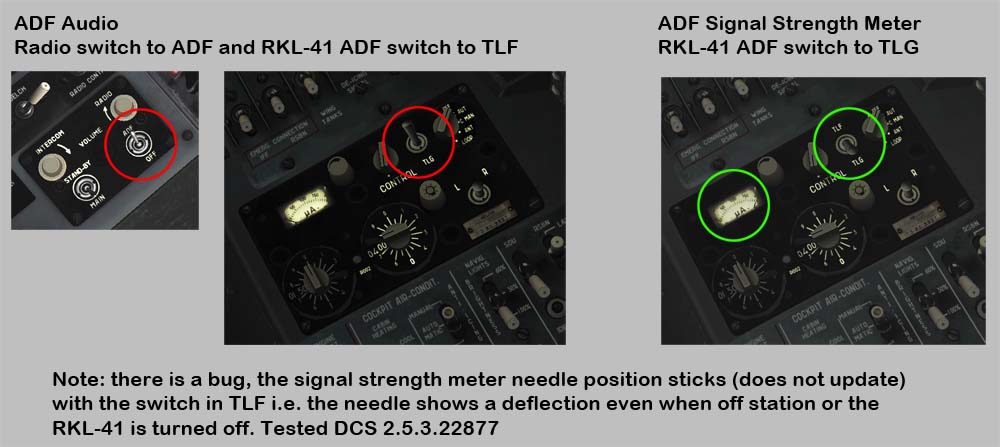
There is a 2-way switch for the signal strength meter on the ADF control panel - switch it to TLG.

Note: there is a bug in DCS as the signal strength meter needle sticks (does not update) with the switch in TLF i.e. the needle will show a deflection even when off station or the RKL-41 is turned off with TLF selected.
Tested DCS 2.5.3.22877
-
First, do we have it, or get it in the future in our hornet?
WIP, coming soon.
-
To give response to some valid posts before on another thread, what is the early access time frame (6 months to a year or when we feel like it)?
Early access usually lasts 6 months to a year but can be longer (i.e. for 3rd parties) as ED makes the final determination.
How long does it last?As long as it takes :(, but even after being 'officially' released - bugs and features will continue be fixed, added and refined.
They placed F/A-18 on the live suite not to long ago. I would think that constitutes full implementation, don't you?No, the Early Access Aviojet C-101 has been included in the release branch for over 3 years.
I bought F/A-18C on 01/13/2018. How much time does it take to come into full fruition?It's not unusual for modules to take 2 years to refine their flight model and the F-18C is a complex aircraft with many systems still to implement, so with A2G radar, etc. it could take longer
They released a YAK aircraft since then.Different teams work on different projects, the YAK was developed for a 3rd party with permission to release/sell a public version.
Come on ED you have not finished models you have released before releasing new models!ED/BST are working on many modules in different stages of development. Some will be released to Early Access and may well be completed before the Hornet, as it is one of the more complex modules.
-
Pardon my ignorance, I'm still discovering what is in this sim. Are the carrier operations part of DCS 2.5 or is it in installed mod?
The CVN-74 Stennis is part of 2.5, there are a couple of 'Instant Action' CASE 1 and CASE 3 Carrier Landing Missions included with the Hornet but so far I've only landed on carriers I've placed in my own missions made in the editor.
What might confuse you re:mods is there are some optional user scripts and camera mods that add extra options for AI text player feedback ('you're high') and/or better views for a coop LSO, video editing, etc.
-
But the first and the last bombs doenst hit again.
Am im flying to low or the angle or something?
Doesn't look too bad IMHO, you just need to improve your technique and practice.
I make plenty of mistakes myself but I'll give what feedback I can
• I use the radar altimeter but it's use depends on terrain and altitude, so is less of an issue.
• In your 1st release, you didn't reduce your throttle in the dive, so were at/near M1.0 at release.
• Your release for the 1st pass looked early. Other long/short impacts, looked to be for similar reasons.
This is my basic technique but I'm probably explaining stuff you already known and you just want a little more practice.
I'll attach a track of my attempt (took control after your spawn) - I could attribute my misses to poor timing/flying rather than CCIP problems or anything else.
-
Any chance someone could post the Facebook stuff here?
Just a series of thumbnails of videos Razbam have captured during their visit/research but here you go:
-
IRL pilots turn off the map to improve HSI readability but that's not to say DCS's text contrast couldn't be improved.
-
I join my two track one with cold start one with hot start. I have do the update today and the tracks recorded after that.
Thanks, it makes it much easier to see what is going on.
TL;DR:
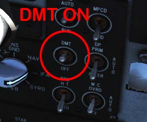
In the cold start you don't turn on the DMT switch (yes I know the TV works but it probably shouldn't).
Detail:
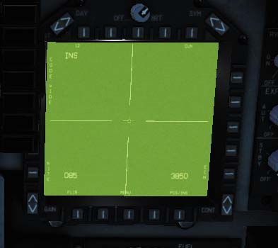
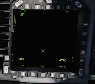
Once you were airborne, the JTAC was lasing and you were trying to get a LST lock
• I took control and used active pause
With the DMT switch off the TV works but LST, etc does not.
• So I turned the DMT switch ON (should have been part of your startup).
• Toggled sensor select forward and aft (INS/TV and LST modes) until I got the correct LST screen (instead of the green TV) and the LST 'X' scanned side to side.
the LST picked up the JTAC's laser and the TV tracked with the moving vehicle.
Tested in DCS Open Beta 2.5.3.22877
-
Really need a track to see if you are setting the bomb profile correctly, you want to be stable (wings level) after the roll-in for approx 5 sec min.
I had no issue (CCIP) with the Mk-20 Rockeyes last night (though did miss a couple of targets), I'm still playing with Mk-82SE quantity and interval to get good AOE damage passes.
I haven't tried single Mk-82's but Rockeye (burst height 1200ft) roll-in were at 8000 ft with release around 2000ft and Mk-82SE (retarded setting) passes were at approx. 500 ft. @ 470 KCAS
Edit: Retested the Snakeyes and they fell long, only way I hit the target dropping singles was to adjust my aim point.
Tested DCS Open Beta 2.5.3.22877
-
Is this based on actual, physical experience or a post? Could you please clarify?
I can't remember if there was a line in the AV-8B's documentation or if it was a comment from Zeus re: TDC forward=pitch down=map scrolls down and vice versa, either way, I can't find my original source to link/quote from.
-
The only way I'm able to create a new waypoint is to enter the coordinates manually.
What I want to do is create a NEW waypoint and set its position by moving the cursor visually on the moving map the same way you do when you EDIT a waypoint.
Is this possible? As the functionality is already built in and working for edits, it seems odd if you weren't able to do this.
I hope I just overlooked something simple. Anyway, if someone could point me in the right direction I'd appreciate it.
Closest I've come to a work around is to add a faux waypoint i.e. N 41°00'00" E 041°00'00" near Batumi, and then use the TDC to slew it where I wanted it.
IIRC you could do the same with Mark Points (so no need to enter coordinates) but I'm not certain how well they are working in the current version.
P.S. The Y-Axis is inverted when editing/moving the position on the moving map. Is this a known bug?IIRC it is how the TDC works in RL.
-
There is already an English cockpit mod (by Quartermaster) that offers a ASI marked in knots
-
Why only these two variants of the Maverick?
Probably for reasons of inventory and maintenance/training in a carrier environment (not only do you need to carry the extra weapons/spares but also the extra test and calibration equipment).
Are the E and F variants of the Maverick the only ones that the Hornet was capable of carrying?Not sure if the other varients were tested ?
From what I have been able to read online, it looks like the E was used mainly by the USMC and the F was designed specifically for the US Navy. Does that mean Navy Hornets only used the F model and was the F model used on only ships or could it be used against land based targets as well?The F is suitable for sea and land use.
IRMV employs a 300 pound blast fragmentation warhead with a selectable delay fuze (instantaneous, D1=14ms or D2=30ms), and is designed primarily for use against hardened targets requiring delayed fuzing such as ships, bunkers, fortified structures, and armoured vehicles.By default it launches in ground mode with the impact point in the centre of IR source, 'sea' mode biases the impact point so as to hit near the water line.
-
Yes, provided your flight has a flight plan/route with waypoints defined in the mission editor (and the NS430 hasn't been disabled in mission options).
An example of NS430 use in a F-5E mission:
-
Probably a dumb question, but I can't get the English cockpit to work. I select it but no changes in game. Any ideas?
Although English Cockpit textures have been added in DCS 2.5.3.22652, mainpanel_init.lua hasn't been updated, so customised cockpit textures don't work.
-
I know you know your stuff, got few replies from you in other threads.
I'm much less certain on this level of stuff.
In that case, would you say that even if the F-5 can scan at 40 miles, it would probably never pick up any contacts unless its a 747?That is my understanding and why the radar is upgraded to an APG-66 or equivalent for BVR (double the range).
AFAIK with the default AN/APQ-159 radar the F-5E was expected (circa 1976) to be guided to the target by GCI, AWACS, etc.
-
Hi guys,
just a quick radar question here. I am alright with using the radar at 10 and 20 miles ... no problem moving the antenna up/down and acquire target. But for the love of god, I cannot detect anything at 40 miles.
I tried everything ... going higher than my target and scan lower ... going lower and scan higher ... being at the same altitude and scan up and down. Can't detect anything, and I am talking about huge plane here (like the Il-76).
Are you guys able to get contact? Any hints?
I think you are expecting to much from the radar.
I did some rough calculations a while ago :-
Typical frontal areas2 m^2 T-38/F-5 ?
3 m*2 MiG-21
5 m^2 F-16 fighter
10 m^2 F-15/Su-27 fighter
100 m^2 bomber
RCS (dB) of the target
X m^2 = log(X) x 10 dB
EDIT: Formula is on page 139
http://calhoun.nps.edu/bitstream/handle/10945/37502/Fuhs_Radar_Cross_Section_1982.pdf
Known data (Flat plate Antenna)
===============================
T-38
2 m^2 = 3 dB
Detection range = 10.5 nm @ 20,000 ft
Estimated detection ranges @ 20,000 ft
======================================
MiG-21
3 m^2 = 5 dB
Detection range = (5dB/3dB)^(1/4) x 10.5 nm = 1.14 x 10.5 nm = 12 nm (+14%)
F-16
5 m^2 = 7 dB
Detection range = (7dB/3dB)^(1/4) x 10.5 nm = 1.24 x 10.5 nm = 13 nm (+24%)
F-15/Su-27
10 m^2 = 10 dB
Detection range = (10dB/3dB)^(1/4) x 10.5 nm = 1.35 x 10.5 = 14 nm (+35%)
Bomber
100 m^2 = 20 dB
Detection range = (20dB/3dB)^(1/4) x 10.5 nm = 1.61 x 10.5 = 17 nm (+61%)


Very simple Nadir question but...
in SA-342M Gazelle
Posted
The NADIR has only 9 waypoints (no need for extra digits), you'll want to plan/update your own as you fly the campaign and/or make waypoints dual use for both ingress/egress.
The first 9 DCS waypoints will be preloaded into the NADIR from the mission file but they may not be the best for the mission.
AFAIK it's a limitation of the real device.