MF1 Posted March 15 Posted March 15 Hello Ugra Média For Phase 3, the inclusion of at least one French air base would be highly appreciated. ! Indeed, several bases could be within the perimeter of the Phase 3 map and were in service during the Cold War. The Colmar-Meyenheim and Strasbourg air bases hosted various aircraft, including the Mirage F1. Colmar also has the unique feature of having a road serving (airstrip) as a emergency landing site (with parking) just a few kilometers away : ( http://www.france-air-otan.net/STRUCTURE/Pages_web/FAF_Colmar-Meyenheim_Historique_2_Fr.html ) . some Cold War air bases in eastern France : Colmar-Meyenheim (47° 55′ 21″ N, 7° 23′ 59″ E), Strasbourg-Entzheim (48° 32′ 32″ N, 7° 38′ 03″ E), or Metz-Frescaty (49° 04′ 35″ N, 6° 08′ 02″ E) 17
grim_reaper68 Posted March 16 Posted March 16 Near to the zone 3 border, you also have Nancy Ochey and Toul Rosière. And in zone 3 you have the heli base of Phalsbourg 5
MF1 Posted March 16 Author Posted March 16 (edited) Some French Airbases and Dispersed Operating Bases (DOBs) / for Area Phase 3 Colmar-Meyenheim (47° 55′ 21″ N, 7° 23′ 59″ E), Strasbourg-Entzheim (48° 32′ 32″ N, 7° 38′ 03″ E), or Metz-Frescaty (49° 04′ 35″ N, 6° 08′ 02″ E) and Hélicopter Base : Phalsbourg > some more détails : http://www.france-air-nato.net/STRUCTURE/Pages_web/Accueil-Fr.html Thanks @grim_reaper68 and @Bremspropeller null Edited March 16 by MF1 add link 5 3
grim_reaper68 Posted March 16 Posted March 16 (edited) I didn't know there were so much air bases in the East of France. I wonder what are those things (in yellow), those aren't air bases. Edited March 17 by grim_reaper68 2
caramel Posted March 17 Posted March 17 These are the locations of major cities in relation to the air bases 3 1 jE n'AiMe paS LeS maJusCuLes n'imPorte oÚ.
grim_reaper68 Posted March 17 Posted March 17 If you want to have a look at all former air bases on the french territory, you can take a look at this site https://remonterletemps.ign.fr/ For example Montmedy-Marville in 1971 aerial photography https://remonterletemps.ign.fr/telecharger/?lon=5.406515&lat=49.453023&z=13.7&layer=pva&pointer=true&year=1971&mission=3211-0021 3 1
TheSkipjack95 Posted March 19 Posted March 19 Which airbases are planned for inclusion in phase 3 ? Colmar ? Strasburg, Metz, Nancy, Toul ? 2
Vil_Coyote Posted March 19 Posted March 19 https://www.techno-science.net/glossaire-definition/Anciennes-bases-de-l-OTAN-en-France.html
MF1 Posted April 16 Author Posted April 16 Very pleased with the upcoming arrival of this map, which is a much-anticipated playground. The precise work and level of detail are remarkable. But the absence of a French Air Force airfield in the French section is truly disconcerting. Okay, France left NATO command after the 1966 decision, but the country remained in NATO and, along with its allies, ensured defense against the USSR. It's truly regrettable that the western part of the Rhine doesn't have a single French base; Colmar AB or Strasbourg AB have their place. @Ugra : Please don't abandon the French community, just make it a single French base and then, as a poet and singer said, "Oh, think twice, it will be just another day for you, you and me in paradise." 2 1
Bremspropeller Posted April 16 Posted April 16 +1 Give the ALAT people out of Freiburg some FATac air cover! 1 So ein Feuerball, JUNGE!
Lace Posted April 16 Posted April 16 Push the boundary north-west a bit and you can include Lakenheath for the F-15C & E, Bentwaters/Woodbridge for the A-10s, Honington and Marham for Tornado (eventually) etc etc. The problem is, where does the expansion end? There will always be a compelling reason to make the map 'just a little bit bigger'. 1 Laptop Pilot. Alienware X17, i9 11980HK 5.0GHz, 16GB RTX 3080, 64GB DDR4 3200MHz, 2x2TB NVMe SSD. 2x TM Warthog, Hornet grip, Virpil CM2 & TPR pedals, Virpil collective, Cougar throttle, Viper ICP & MFDs, pit WIP (XBox360 when traveling). Quest 3S. Wishlist: Tornado, Jaguar, Buccaneer, F-117 and F-111.
Bremspropeller Posted April 16 Posted April 16 That's not the point. The mentioned bases (Strasbourg, Colmar) are both within the boundaries of Phase 3 (similar to lots of missing german bases). 2 So ein Feuerball, JUNGE!
Lace Posted April 16 Posted April 16 2 hours ago, Bremspropeller said: That's not the point. The mentioned bases (Strasbourg, Colmar) are both within the boundaries of Phase 3 (similar to lots of missing german bases). That's valid. Laptop Pilot. Alienware X17, i9 11980HK 5.0GHz, 16GB RTX 3080, 64GB DDR4 3200MHz, 2x2TB NVMe SSD. 2x TM Warthog, Hornet grip, Virpil CM2 & TPR pedals, Virpil collective, Cougar throttle, Viper ICP & MFDs, pit WIP (XBox360 when traveling). Quest 3S. Wishlist: Tornado, Jaguar, Buccaneer, F-117 and F-111.
MF1 Posted April 16 Author Posted April 16 (edited) @Bremspropeller Thanks ! Indeed, FATAC (Force Aerienne TACtique) is a part of the French Air Force. FATAC is an operational command and a territorial organization supporting its air units. Created in July 1965, FATAC received responsibility for all tactical units stationed in France and Germany following France's departure from NATO's integrated military command. (http://a3ba103.free.fr/Cerpa/Guerre_froide_1961_02_25_fevrier_1961_creation_fatac.pdf ) I really hope that Fatac (French Air Force) will have at least one base ! Our Belgian friends will have eight, and our Dutch friends seven... Edited April 16 by MF1 précision 4
Bremspropeller Posted April 18 Posted April 18 Just to give you an idea - this is as far south as the undeveloped part of the map is extending right now. Next to "MV30" is Phase 3 airfield Baden-Söllingen (outlines visible). Right next to the "2nm scale" on the botton left would be Strasbourg - outlines visible as well. This is the farthest south the (undeveloped) map is extending right now. Phase 3 would extend a good part more to the south. The Rhine river isn't in there yet at this part - it would run along the diagonal stretch of woods (flowing southwest-northeast), stretching through the center of this frame. 1 1 So ein Feuerball, JUNGE!
Bremspropeller Posted April 18 Posted April 18 (edited) Outlines of Grostenquin at LV33: Outlines of Phalsbourg (barely visible) in LV60: Edited April 18 by Bremspropeller 2 So ein Feuerball, JUNGE!
Bremspropeller Posted April 18 Posted April 18 Just did a quick look south. This is Baden-Soellingn up close: Spoiler Spoiler Strasbourg: Spoiler Spoiler This should be Lahr: Spoiler Bremgarten: Spoiler So using the drawn map above, I hopped back across the Rhine to find Colmar: Spoiler Spoiler May or may not be in the scope, but I think Ugra could be bribed into it - it's less than 15km west of Bremgarten after all... 3 1 So ein Feuerball, JUNGE!
MF1 Posted April 18 Author Posted April 18 @Bremspropeller and @grim_reaper68 Thank you for your attentive aerial overview ! This seems rather encouraging. Talking with players (French, of course), the community is really looking forward to one (at least) French airport . 2
Bremspropeller Posted April 18 Posted April 18 I think we will have to nudge Ugra into it and keep up the nagging until they have no other choice. There are a couple of turkish airports on the fringes of the Syria map, that look the same, but haven't been modelled. There already are a good number of turkish airfields on the Syria map, though, so the additional value of those was low. There are currently no french airfields planned and implementing them is basicly a quick-win. The good advantage here is the proximity to the airfields that already going to be modelled. Certainly that is the case for Strasbourg and Colmar. 3 So ein Feuerball, JUNGE!
MF1 Posted April 22 Author Posted April 22 STRASBOURG - Entzheim While waiting for the future on the Germany Cold War map... a bit of history (before cold war) about the Strasbourg Entzheim base The frontier station of Strasbourg - Entzheim was replaced by the air stop at Strasbourg-Nuhof on 15 February 1923. It was then established on only 30 ha Having decided, with their agreement, that the Entzheim aerodrome would be "the final commercial airport in Strasbourg", the Air Minister asked local authorities in 1934 to participate in the extension work which were to cover 65 ha. Following the fact that the project was declared public in August 1936, its execution was terminated in 1939 before the operation, south-west of the airfield, the construction of the terminal which was naturally planned to be served by the Strasbourg road. Since Strasbourg has meanwhile become the seat of a main radio-goniometric station, a landing area in poor visibility was introduced in an approach area on either side of a substantially east/west-oriented descent axis. This sector was protected by an easement plan as well as the one framing a second oriented E-S-E / O-N-O axis. Night marking would be achieved while the visibility-free landing device (radiophar, radio beacons, light pads and approach projector) could already be used when war broke out. The land thus developed was intended to allow the use of three axes of flight length of 1 150 m, 1 400 m, and 1250 m usable. While the south of the terrain had been restored to culture, the Germans established on its eastern part a 12 m wide gravel road with refuges for the garage and protection of heavy aircraft and whose horseshoe route (flagged on the map) developed about 1,800 m. Taking possession of the place, the Americans also used only the surface of the old land. In March 1945, on the other hand, they undertook the construction of a steel plate runway for French aviation. Affected to commercial traffic and private aviation in June 1946, Entzheim airfield retained American traffic lanes only the one north of the runway for its part west of the eastern end of the runway. Opened without restrictions on public air traffic by the ministerial order of 6 February 1947, the Strasbourg-Entzheim airfield will live on this device until the very beginning of the 50s when, breaking with the provisional, a runway with the characteristics of the Air Force will be built according to the optimum N-E/S-O orientation vis-à-vis the regime of winds as well as the relief and existing obstacles. https://www.anciens-aerodromes.com/?p=25095
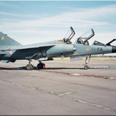
MF1 Posted April 27 Author Posted April 27 Colmar-Meyenheim Air Base 132 : This base housed the first all-weather fighter aircraft operated by the French Air Force: the F86-K. Below is a video discussing the use of the North American F86 K-model at the Colmar airbase (video with audio track in English) during the early part of the cold war :
Recommended Posts