graveyard4DCS
-
Posts
162 -
Joined
-
Last visited
Content Type
Profiles
Forums
Events
Everything posted by graveyard4DCS
-
That one is for me I suppose. 99% of the info that I compiled regarding bomb fuzes are freely available. Not even a free membership needed. But that doesn't mean there's no need for an official doc.
-
 You're totally right, TAWS relies on a DTED model. My remark came from the fact that NASA's SRTM mission took place in 2000, and before that the elevation data was available mostly in "friendly" territories only. This was an issue because training with tools that you don't have in war time is "negative training". Also weapon systems were not as integrated as they are today, so having a DTED available for TAWS doesn't imply it's available for TGP trigonometry. I don't say it was the case, I just say it's not obvious. For example, the M2000D has a terrain elevation model, but it's only available for terrain following. Anyways, it's an interesting question, I'll try to look if we can find docs about TGP's coordinates in the Hornet.
 -
It could work, but I don't think there's a full elevation model in the Hornet's weapon system. This feature is available for more modern aircraft only. And there's a large error with such methods, making it unusable for GNSS weapon use. It's only when there's a clear line of sight and the laser telemetry is working that you can get a good precision, even if that precision is in reality not always suitable for GNSS weapons use. Also inaccuracy in linked to the angles: the closer you are to the vertical, the lower the uncertainty. And eventually, as it's derived from your own position, the precision of your navigation system matters a lot.
-
Kandahar at some point. During the very early days of OEF they departed from Pakistan. You can read the Osprey books about A10s during OEF: 2002-2007 and 2008-2014. I also made a short book review here (personal page, not ED's forum) .
-
High drag bombs - incorrect fusing behavior
graveyard4DCS replied to Diesel_Thunder's topic in Weapon Bugs
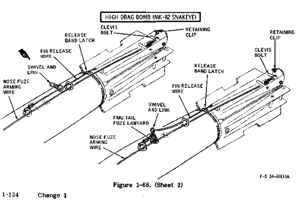
You're right, there can be a M-905 mechanical fuze with high drag bombs. However, note that technically speaking the nose/tail option let you select a wire on the bomb, and it can be different from the actual fuze arming. For example, in general on high drag bomb the tail wire will open the chute and the nose wire will arm the fuzes, whether they are nose and/or tail. Obviously making the nose wire arm the nose fuze and the tail wire arm the tail fuze is the most logical, but the case of the Snakeye shows you that it's not always the case. The same question arises for LGBs, because for example the Paveway guiding kit must be ignited and the tail wing deployed, and that also the role of arming wires as selected by the tail/fuze option. Ideally, these details should be modelled so that we know more precisely what consequences the nose/tail options will have in game. Currently, we can only make guesses...
-
Also theoretically this is an impossible match. The DSU-33 is a proximity sensor triggering electronic fuzes. M-905 is a mechanical fuze that only triggers to impact. There's no way you can trigger it with a DSU-33.
-
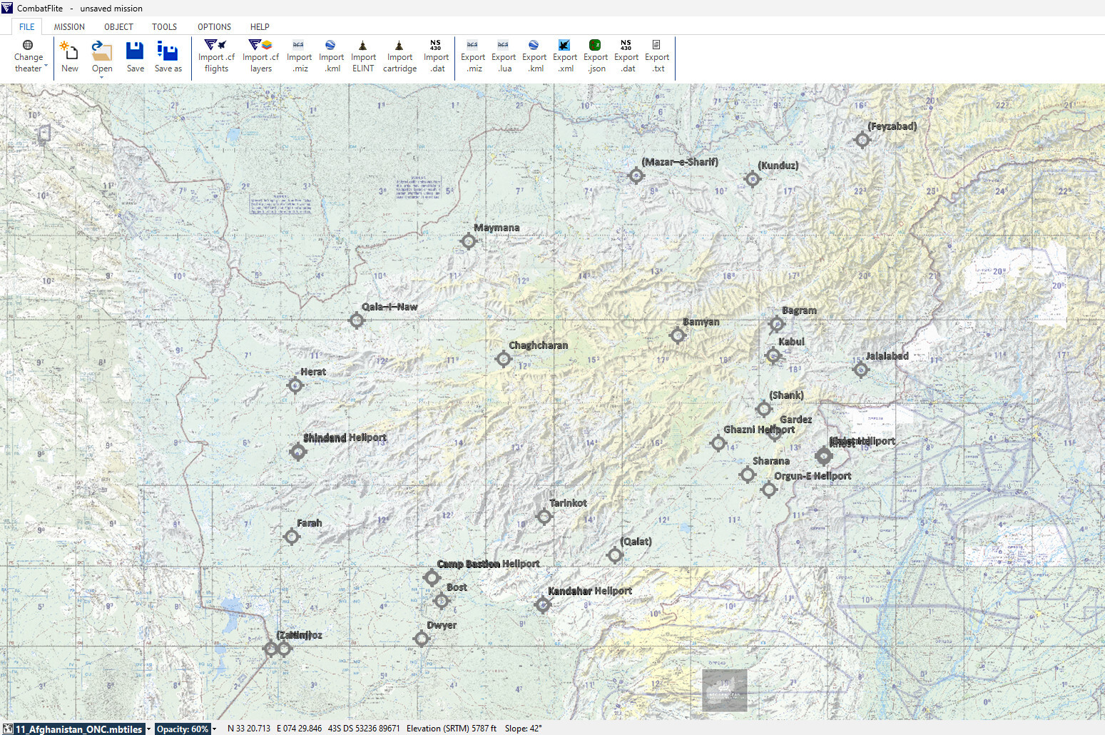
Hi @MemphisBelle Note that some of the maps are available for download for free by registered members, it might be wise to test them before you go for the whole package. I can't upload all of them on ED's user files due to maximum file size restrictions. Note also that I made many posts to explain how to install those theaters. Please read them first, starting by the oldest ones, I'm pretty sure you'll find all your answers. Now as a quick summary for those interested : - mbtiles files are the new maps to put in an existing CombatFlite/Data/theatername folder - .hgt files will give you the terrain elevation data - new .xml files can replace the old ones to have all the airfields and NAVAIDs for the new theaters - the theater.xml file can also be modified to allow. miz file import and export with new theaters (little more tricky) All these files have been made available, so that all CombatFlite features keep working on the new theatres. Thanks
-
I tried to explain here the parameters to take into account to place the tankers, in Afghanistan or elsewhere. There's also a tentative ACO for the early OEF campaign. I'll work on a later OEF ACO in the future.
- 25 replies
-
- 2
-

-
- missiondesign
- afghanistan map
- (and 1 more)
-
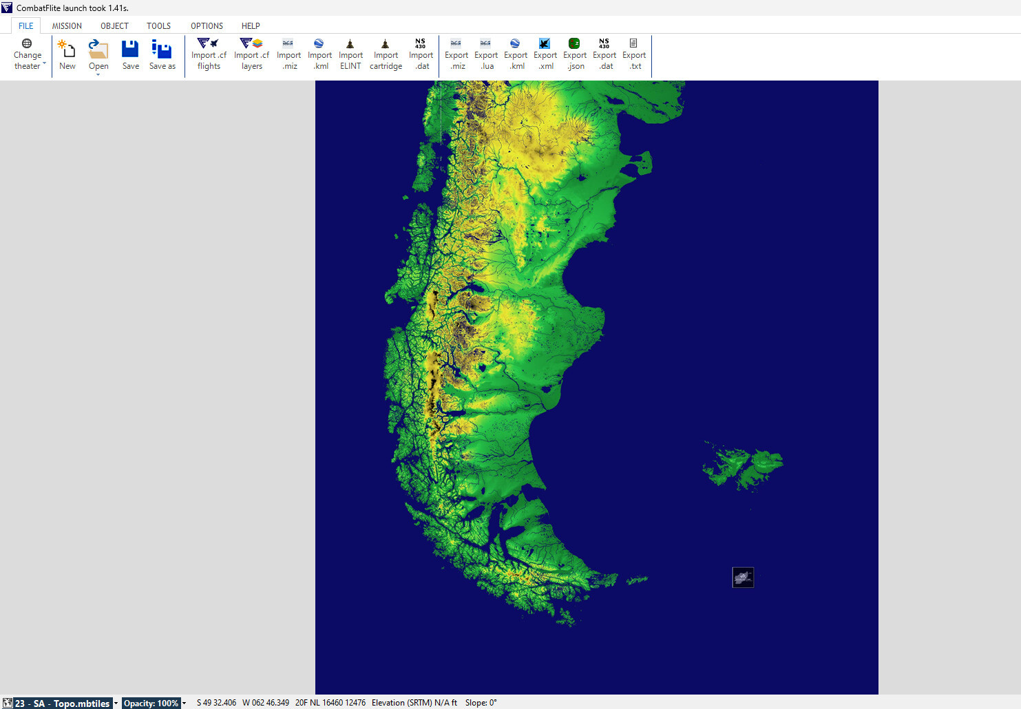
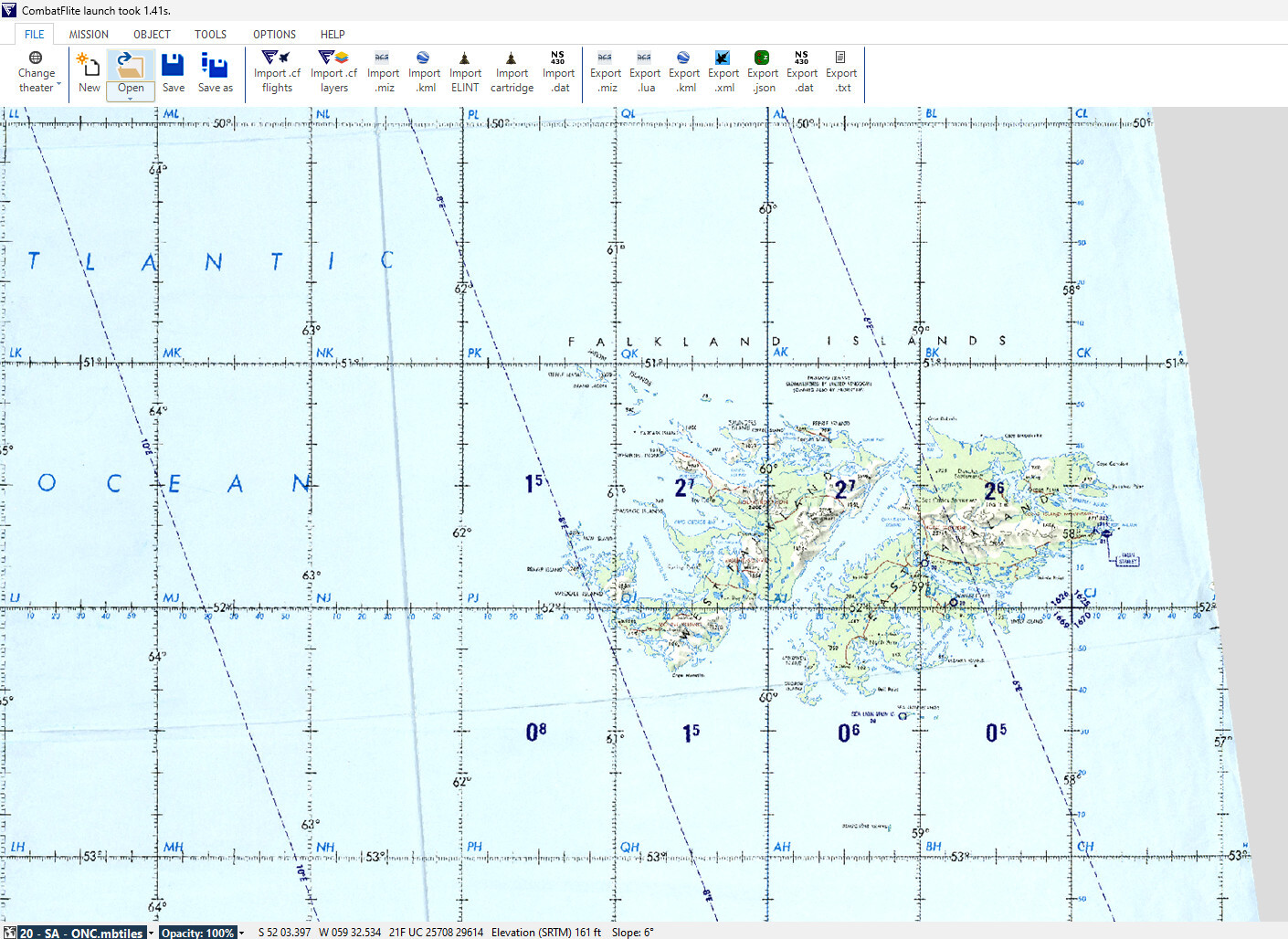
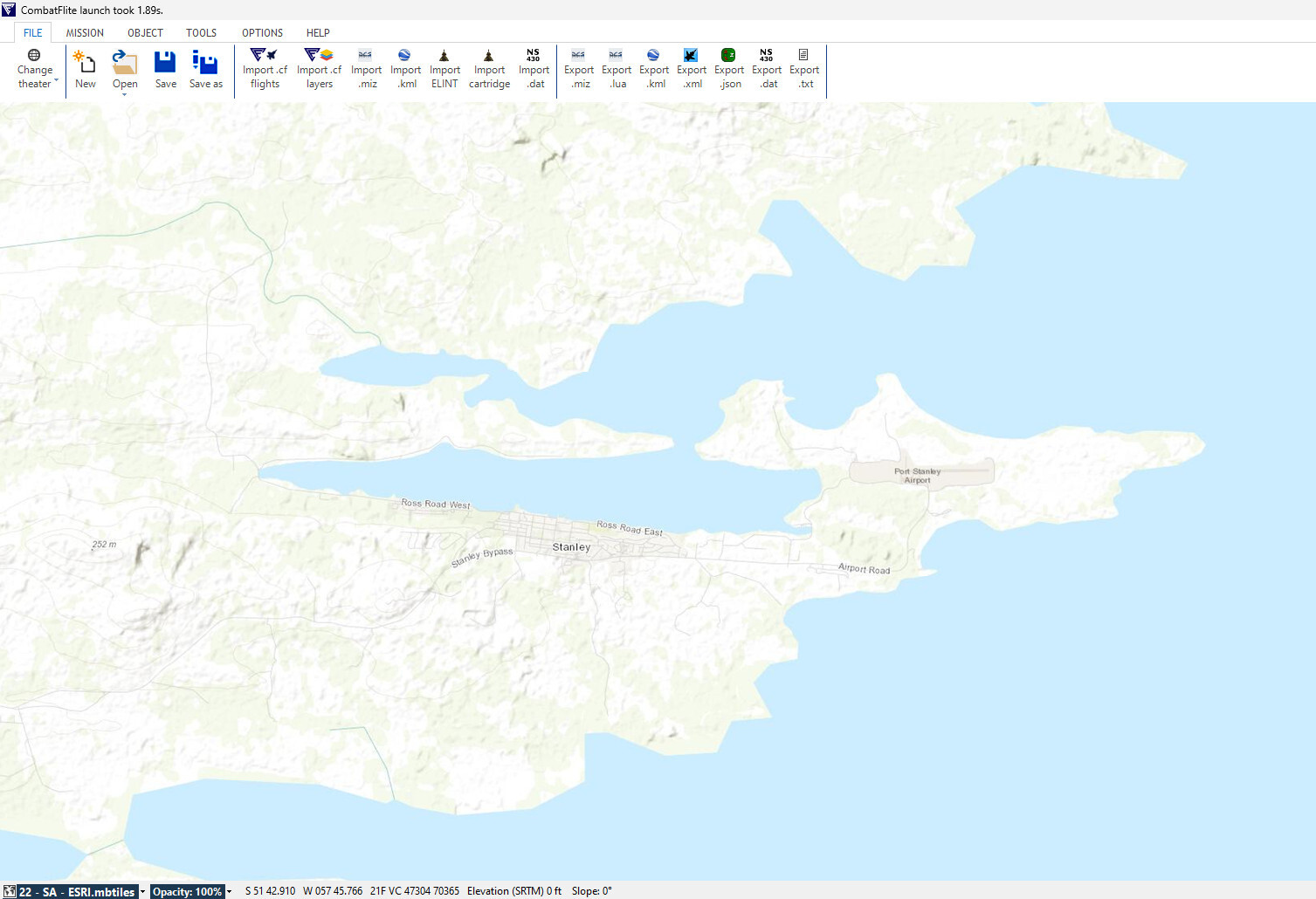
South Atlantic Theater for CombatFlite
graveyard4DCS replied to graveyard4DCS's topic in South Atlantic
Hi, Yes CombatFlite is a mission planner, very similar to mission planning tools used by military forces. There are plenty of handy options, like intervisibility calculation tool, or mission data card generator. It can also be used to load the flight plans automatically when using tools like DCS-DTC. You can watch videos on YouTube to discover it: Note that I don't have any link with the software developer. I just created additional content to use latest theaters with that tool. -
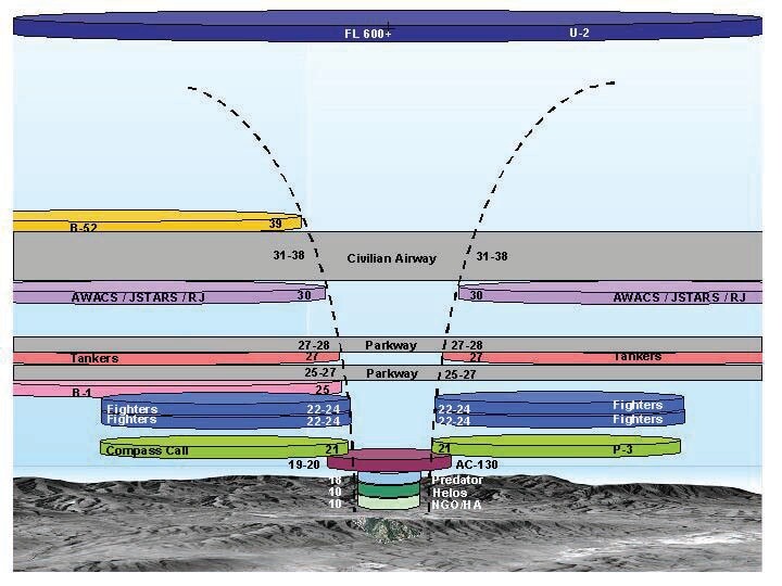
What you described above was already in use in the early days of OEF, as per US doctrine about airspace management (ACO, etc...) The other major deconfliction tool was the killbox system using the CGRS grid. I shared on my personal page the CGRS grids used during OEF for different time periods.
- 25 replies
-
- 3
-
-
- missiondesign
- afghanistan map
- (and 1 more)
-
For those interested, an updated .xml file with latest East Afghanistan airfields for CombatFlite has been released.
- 23 replies
-
- 1
-
-
- graveyard4dcs
- afghanistan map
- (and 2 more)
-
Following several people's request, I also shared elevation data (.hgt files) for this theatre. How to find the original data is explained here. More posts about CombatFlite and other theaters there.
-
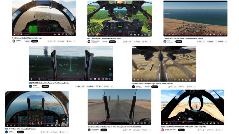
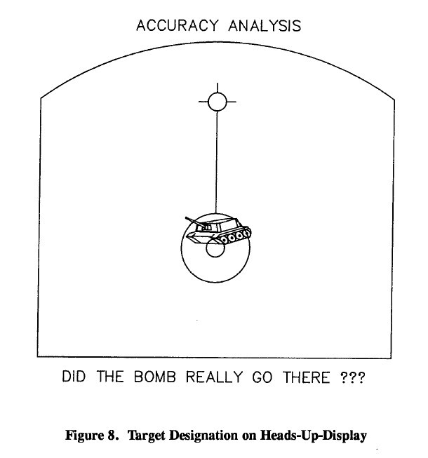
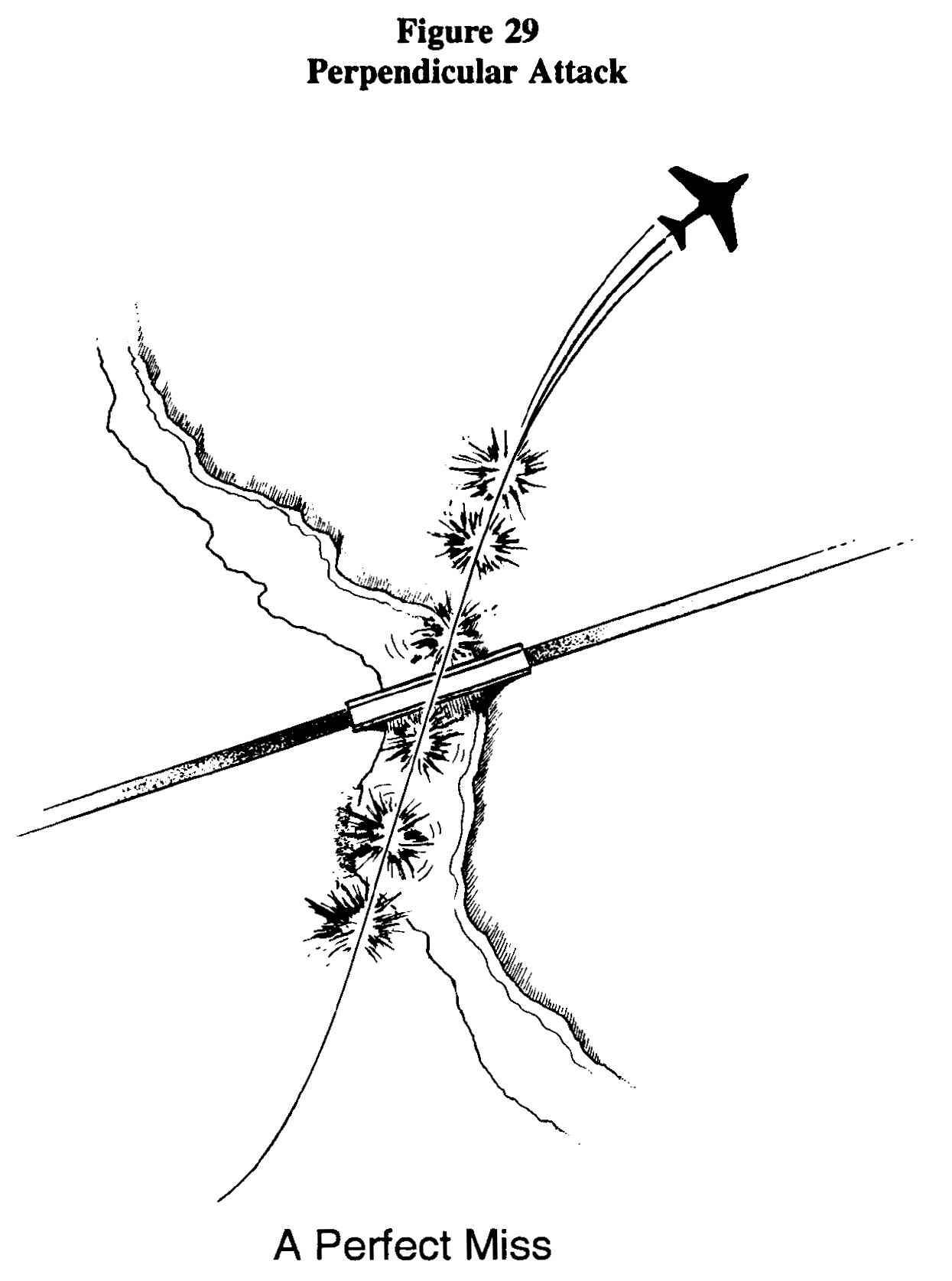
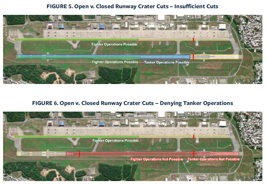
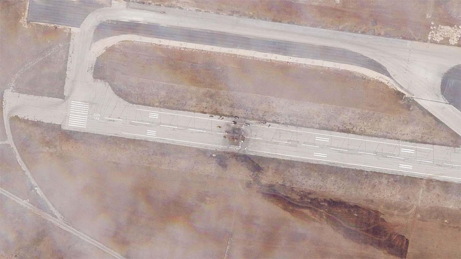
Runway Attacks in DCS World: Is (Almost) Everyone Doing It Wrong ??? Note: this post might sound a little provocative, but that’s intentional. Its purpose is not to criticize but to provide an insight into what tactical thinking can look like for real fighter pilots. Runway attacks are more than just dropping bombs—they require careful planning, an understanding of weapon dynamics, and a mindset that balances risk and reward. By the end of these articles, you’ll see why so many virtual pilots get it wrong and how you can get it right. Runway attacks in DCS World are among the most thrilling and demanding missions a virtual pilot can undertake. The combination of flight precision and the high-stakes environment of overflying a heavily defended airfield makes a successful strike incredibly rewarding. However, despite their popularity, many pilots fall into the same traps when attempting to crater runways using unguided "dumb" bombs in 20th-century combat scenarios. If you've ever watched DCS runway attack videos on YouTube, you've probably noticed that the same tips are repeated over and over again. The most common mistake repeated by their authors is to attack parallel to the runway, a tactic that is not optimal in terms of overall efficiency. (Nearly) all Youtubers will show you parallel runway attacks... I will try here to discuss the most common errors and lay out the key principles for executing a successful runway attack. The Core Issue: Ignoring Aiming Errors One of the biggest oversights in runway attacks is the failure to account for aiming errors and the optimal attack direction. Bomb accuracy is influenced by several factors, many of which are often overlooked: Crosswind drift: wind can push bombs laterally, causing them to miss the target. Height vs. piper depression: higher release altitudes increase the potential for sighting errors. Parallax issues: differences between the pilot’s viewpoint, the HUD aimpoint, and the actual bomb impact point can lead to inaccuracies. Bomb ballistics: all bombs are very susceptible trajectory deviations, during the separation phase for example, or due to pilots movements during bomb release, and high drag bombs are very susceptible to wind, making them less predictable. Even in modern aircraft equipped with advanced systems like INS and radar ranging, these errors persist, even if it's to a lesser degree. Pilots must therefore plan for these inaccuracies rather than assuming a perfectly aimed bomb run will yield perfect results. Aiming errors are systematically studied for each weapon and each weapon system in order to compute CEP (Circular Error Probable) and refine bomb delivery methods. Example from "AGARD Flight Test Techniques Series - Volume 10 - Weapon Delivery Analysis and Ballistic Flight Testing". This lack of understanding manifests in two critical mistakes: 1. Attacking Parallel to the Runway The most widespread error is conducting bombing runs parallel to the runway. While this approach might seem intuitive, it significantly reduces the effectiveness of the attack. The main issue it that aiming errors combined with a parallel attack vector can result in all bombs landing entirely to one side of the runway. This leaves large sections intact and still usable. Or even worse, all bombs can land off runway... Example of attack perfectly parallel to the runway. However, attacking perpendicular to the runway isn’t a perfect solution either. As highlighted in historical accounts like Operation Desert Storm, a perpendicular attack with a string of bombs can still fail if the spacing between bombs coincides with the runway’s width. This means that even a well-aimed release can result in wasted ordnance if the bombs fall into the gaps between the runway’s critical sections. Excerpt from "Gulf War Air Power Survey - Volume IV - Weapons, Tactics, and Training". The key is to find a balance. Pilots should aim for an oblique angle—neither perfectly parallel nor perpendicular—to maximize the likelihood of hitting the runway while minimizing the risk of wasted bombs. 2. Poorly Calculated Bomb Intervals Another common mistake is failing to compute the correct interval between bombs. This leads to one of two problems: Bombs too close together: overlapping craters waste ordnance and fail to maximize the damaged area, or even worse, result in all bombs falling long or short of runway. Bombs too far apart: Large gaps between impacts allow aircraft to maneuver around the damage and continue operations, when we don't have a bomb before and the next one after the runway. The key is to strike a balance. Pilots must calculate bomb intervals based on expected aiming errors, runway width, and the number of bombs available. This ensures that at least two or three bombs reliably crater the intended section of the runway, creating an effective denial zone. 3. Not Targeting the Most Critical Runway Points Many pilots distribute their bombs too randomly, failing to prioritize the most critical areas of the runway. Identifying the best Desired Mean Points of Impact (DMPIs) on the runway is crucial for maximizing effects. Key DMPIs include: Runway intersections: disrupting these prevents aircraft from using several runways in a single strike. Runway access points: damaging these disrupts both runway use and ground operations. Thresholds and center sections: the idea is to make sure that no undamaged part of the runway is long enough for take-off or landing. That length will depend on the type of aircraft based on the airbase. Taxiways intersections: damaging these disrupts ground operations. Case study of runway cuts depending on the type of aircraft. Source here. Even with modern precision-guided munitions, targeting these high-impact areas ensures optimal disruption of airfield operations. 4. Poor Multi-Aircraft Coordination While a single aircraft can cause temporary damage, a coordinated strike is essential for full runway denial. Common errors in multi-aircraft attacks include: Dropping bombs in the same area: this wastes ordnance instead of maximizing coverage. Improper timing or geometry: following aircraft risk damage from bomb fragments of the first wave. Deconfliction failures: poor planning can result in aircraft interfering with each other’s attack runs, at a time when pilots must be entirely focused on their target. Effective coordination requires precise timing, well-planned spacing, and a clear target assignment strategy. Each aircraft should focus on a specific section of the runway to ensure comprehensive coverage. Conclusion: Rethinking Runway Attacks If virtual pilots want to truly deny an enemy’s runway, they must move beyond random bombing runs and adopt a more methodical approach. The mistakes outlined above highlight the need for careful planning and execution. In the next posts on my personal page, you’ll be invited to dive deeper into the specifics of runway denial, including: Case studies of real-world examples: learning from historical runway attacks, such as Operation Allied Force. Systematic study of proper techniques: breaking down optimal offset angles and spacing. Data-driven decision making: providing tables and figures to help you choose the best attack parameters. In the mean time, I invite you to engage a discussion here, and tell me if my analysis sounds meaningful, or how you would adapt it to modern PGMs (Precision Guided Munitions)! Runway under repair at Aleppo after an Israeli strike with a single PGM.
- 7 replies
-
- 10
-
-

-
South Atlantic Theater for CombatFlite
graveyard4DCS replied to graveyard4DCS's topic in South Atlantic
Update : ONC and ESRI maps have been released. Elevation data (.hgt files) will follow shortly. If by any chance someone has other maps available (like TPC, modern VFR, or any aviation map), don't hesitate to contact me in order to transform them in .mbtiles and make them usable in CombatFlite! Thanks, -
You're right, newer missile should have better ECCM (Electronic Counter Counter Measures), especially since imagery sensors have replaced old bar sensors. Flare detection and rejection is a major ECCM capability, with associated behaviour to find back the original target.
-
Bomb Fuzes options in the rearming panel
graveyard4DCS replied to graveyard4DCS's topic in General Tutorials
Yes, you have understood correctly. It is similar to what's done for real. Laser code on the Paveway family bombs are set manually by turning screws on the bomb's head kit. In the cockpit, you still have to select the laser codes that you are using for lasing and LST. -
You can check https://milais.org/ for airfields in Norway (FLIP Vol. 1) There are also plenty of charts on the Internet archives for older charts.
-
A first elevation map for CombatFlite has just been released, it's available here. More maps will follow (ONC, ESRI, etc...) For those who'd like to know ho to setup a new theater for CombatFlite (airfields, NAVAIDs, elevation data, .miz import/export, etc...) , it has already been detailed here. Enjoy your planning!
-
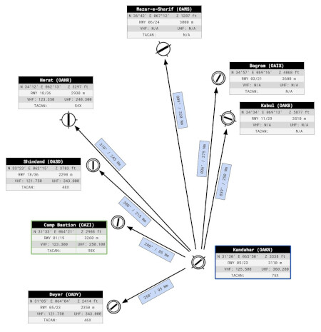
For those interested, and following this general discussion about diversion airfields and fuel calculations, I released a generic kneeboard page for diversion at Kandahar airfield. In a couple of days, you will also find another kneeboards with precise fuel calculations for the F/A-18C Hornet and Mirage 2000C.
-
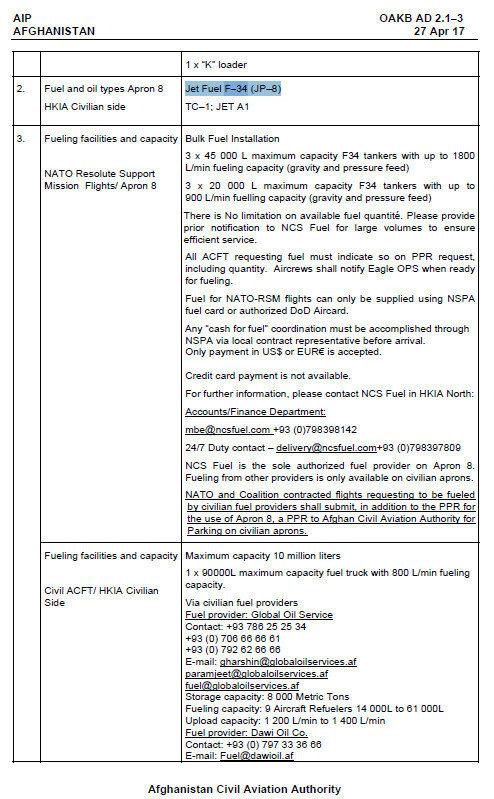
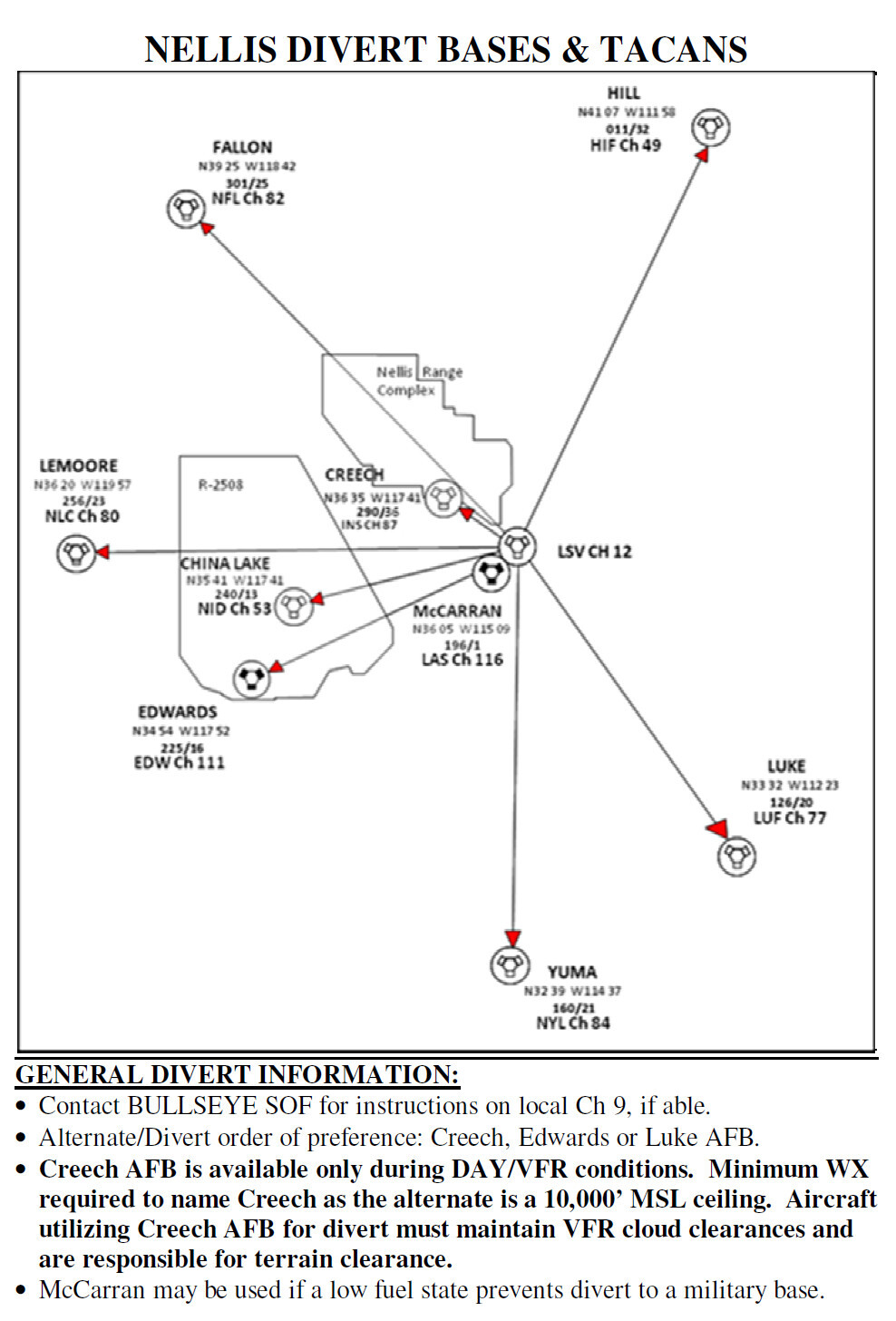
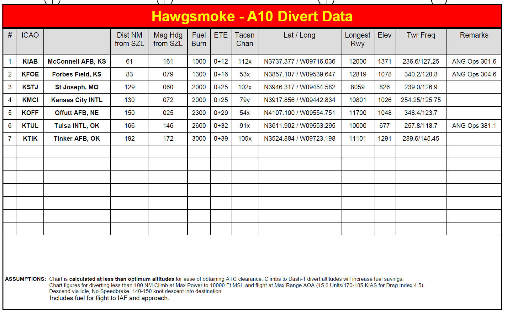
Hello ! I'd love to hear how you approach fuel calculations in a combat environment, and more specifically the minimum fuel for landing or in-flight refueling, a quantity of fuel that is closely linked to the diversion airfields you've chosen. To kick-start the discussion, here's a short article introducing the concept of diversion airfields in the context of military aviation. Enjoy your reading! Diversion Airfields for HPMA: Introduction In military aviation, safety and mission effectiveness depend heavily on having well-planned contingency options. Diversion airfields are critical elements in ensuring that HPMA (High-Performance Military Aircraft, i.e. fighter jets) have a safe haven in case their primary destination becomes unavailable. These airfields act as lifelines, particularly in dynamic operational environments where emergencies, adverse weather, or other unforeseen factors (like enemy military action) can disrupt mission plans. I'll introduce here the purpose of diversion airfields, the principles of fuel planning, and the additional considerations that ensure mission success, before a next article that will apply it to the Afghan case. Diversion Airfields: Purpose and Selection Diversion airfields are carefully chosen to meet the operational demands of HPMA. These selections are based on factors such as proximity to the mission area, runway capabilities, support infrastructure, and overall security. For military jets, runway length is a paramount consideration, as the runway must accommodate the high speeds and potential heavy payloads upon landing. The availability of military-grade fuel, maintenance services, and munitions handling facilities further influence the choice of suitable diversion airfields. In high-threat zones, security becomes an equally important factor. Diversion airfields in such areas must be secure from enemy activity and equipped with defensive measures to protect personnel and assets. AIP page for Kabul International Airfield stating that military grade F-34 fuel is available: it's a suitable diversion option in terms of fuel. Another crucial aspect of diversion airfield planning is the strategic placement of at least two suitable options near the primary recovery base. This ensures operational flexibility and contingency coverage, as the fuel requirements upon arrival at the primary airfield depend not only on its weather conditions but also on the conditions at these alternate diversion sites. This approach mitigates risks and enhances overall mission safety. However, since alternate airfields choice is a risk management decision, the rules can be changed depending on the actual operational situation by a commander with the sufficient level of authority. For example, we can imagine that reducing the alternates option to a single airfield can be decided, or even to no alternate options, for carrier operations at large for example (also called "blue water ops"). Fuel Planning and Minimum Reserves Given their high instantaneous fuel consumption, fuel planning for military jets needs to be a meticulous process that balances operational requirements with safety. The calculation begins with estimating cruise fuel burn, which is the amount needed to reach the diversion airfield under normal cruise conditions. Reserve fuel is then added to account for potential deviations, holding patterns, or emergencies. These reserves are critical, as they allow pilots to execute specific procedures after reaching the diversion airfield. National regulations often dictate the specific procedures enabled by minimum fuel reserves. For example, in France, the minimum fuel for VMC/day operations ensures the ability to perform a go-around procedure followed by 10 minutes of low-level navigation before bailout. For IMC/night operations, the reserves account for a go-around, a second IMC procedure, another go-around, and an immediate bailout. In contrast, civilian aviation adheres to stricter fuel reserve rules, such as carrying enough fuel to reach an alternate airport plus 45 minutes of holding time. While effective for commercial airliners, this approach is totally impractical for high-performance military aircraft. Following such rules would leave combat aircraft with virtually no fuel for combat operations. Instead, military fuel planning emphasizes adaptability, incorporating real-time mission demands and environmental conditions. Note that additional fuel reserves are often allocated to account for local circumstances. For example, operations may require extended holding times due to heavy air traffic or regular runway closures. For example, in Afghanistan these closures could result from routine inspections, such as those conducted after mortar attacks on airfields. By anticipating these factors, mission planners ensure that pilots have the fuel needed to navigate complex and unpredictable scenarios. Military personnel taking cover in a bunker during a rocket attack at Kandahar airbase. Essential Diversion Data for Mission Planning The effective use of diversion airfields relies on having accurate and comprehensive data. Inflight guides and mission planning tools need to be created in order to provide essential information to ensure safe and efficient in-flight decision-making. Key data points include: Relative Location: information on range and heading to diversion airfields helps pilots quickly assess options. For example, Creech AFB is located 36 NM from Nellis AFB on a heading of 290°, while Edwards AFB is 160 NM away at 225° (see picture below). Runway Dimensions: runway length and orientation are critical for landing and takeoff. Diversion airfields like Edwards AFB offer long runways (15,000 feet), while others like Creech AFB provide shorter options (9,000 feet) suitable for day/VFR conditions . Navigation Aids (NAVAIDs): TACAN or VOR frequencies allow for precise navigation. For instance, Creech AFB operates on TACAN Channel 87 (INS), while Edwards AFB uses Channel 111 (EDW) . Ideal Transit Altitude: specified altitudes optimize fuel consumption and air traffic deconfliction. For example, en route altitudes to diversion bases in the Red Flag exercise range from FL190 to FL250, depending on the distance . Fuel Consumption for Transit: guides often include fuel usage for specific routes. For example, transitioning to Fallon NAS from a specified location requires 5,000 pounds of fuel with reserves . Example of diversion data for Nellis. This picture is not specific to an aircraft type. Understanding the assumptions underlying these fuel calculations is also vital for their effective application. Assumptions often include factors such as the aircraft’s load, weather conditions, expected airspeeds, and transit altitude. Assumptions about payload configuration will impact fuel burn rates, particularly for aircraft carrying external stores. By knowing these underlying assumptions, pilots can adjust calculations to reflect real-world conditions and adjust the fuel to the closest necessity. Detailed assumptions made for fuel calculation by a A-10 crews for a live fire exercise. Another important consideration is how this data is presented. Diversion data is typically displayed in either tables or graphical representations. Tables provide structured, detailed information such as range, headings, runway lengths, and fuel requirements. However, graphical presentations, such as maps with overlayed annotations or visualized flight paths, are often more effective in operational contexts. A visual representation allows pilots to quickly grasp critical information, including the relative positions of airfields and key navigation details. This is particularly useful in high-stress situations where rapid decision-making is essential. While tables remain a valuable planning tool, graphical presentations offer a clearer, more intuitive way to process information during flight operations. Another example of divert data presented in a table: while all the information if readily available, it's certainly less easy to use in flight than a schematic representation. These data points, combined with mission-specific factors, enable pilots and planners to make informed decisions. By integrating this information into pre-flight planning and real-time operations, military aviation maintains its focus on safety and mission success. As a conclusion, we can say that developing accurate diversion data and graphical kneeboard pictures for every deployment base is a mandatory step to improving mission planning and in-flight diversion execution. These resources ensure that pilots can make efficient and reliable decisions, both on the ground and in-flight. In a following post, I will give you an example by as creating detailed diversion data for operations in Afghanistan, focusing particularly on Kandahar.
-
Thanks for the head's up! However, please note that IFR waypoints are seldom used by fighter jets for departure and recovery procedures, let alone VFR ones. That's most probably the reason why you don't see them appear in the docs I compiled. Nevertheless, you'll find some of the VFR waypoints in those charts instead. Obviously, these IFR waypoints are heavily used by all civilian and military strategic transport aircraft following IFR rules to Kandahar.
-
Soon
- 23 replies
-
- 2
-
-
- graveyard4dcs
- afghanistan map
- (and 2 more)
-
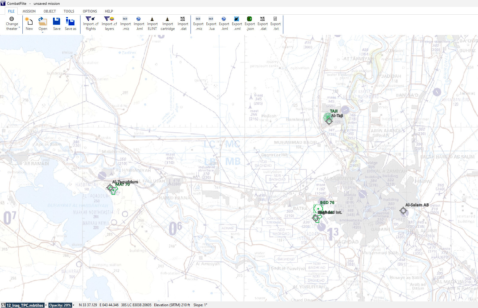
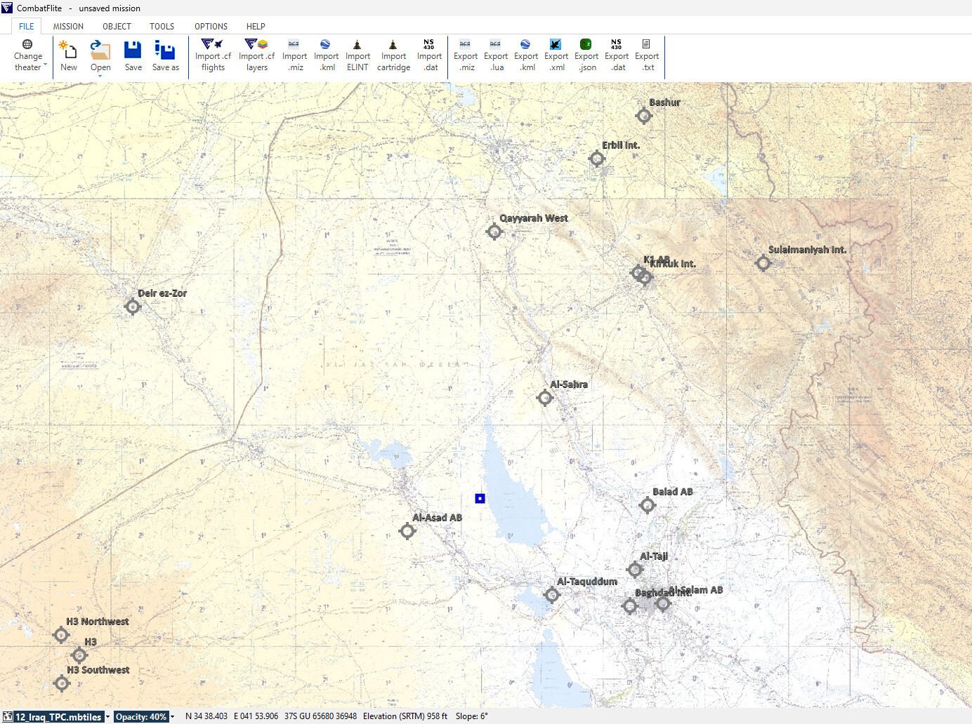
ONC, TPC, topo and ESRI maps, as well as all current airfields for the Iraqi theater in CombatFlite are now available as well. Enjoy! (Note: NAVAIDs data still WIP).
-
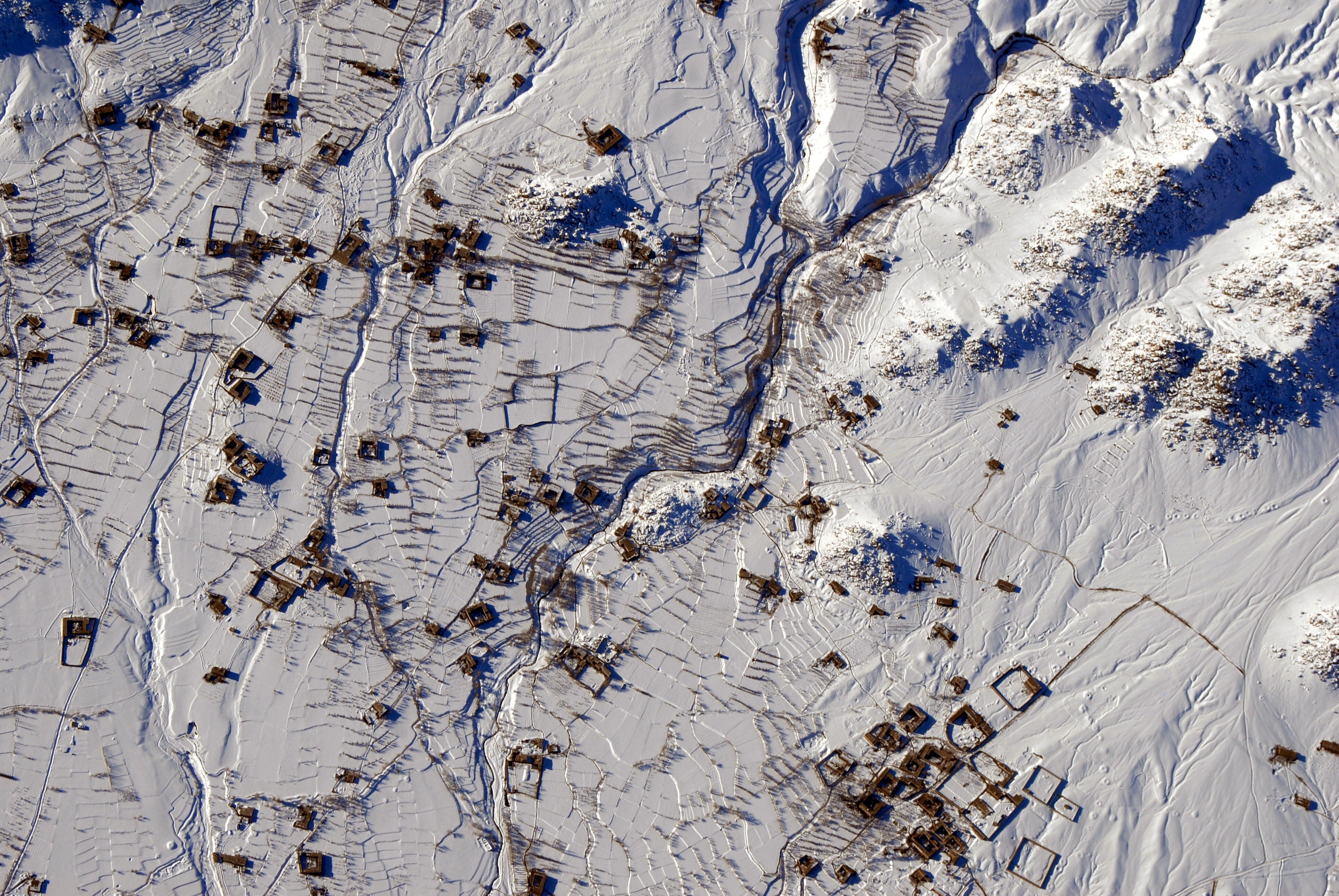
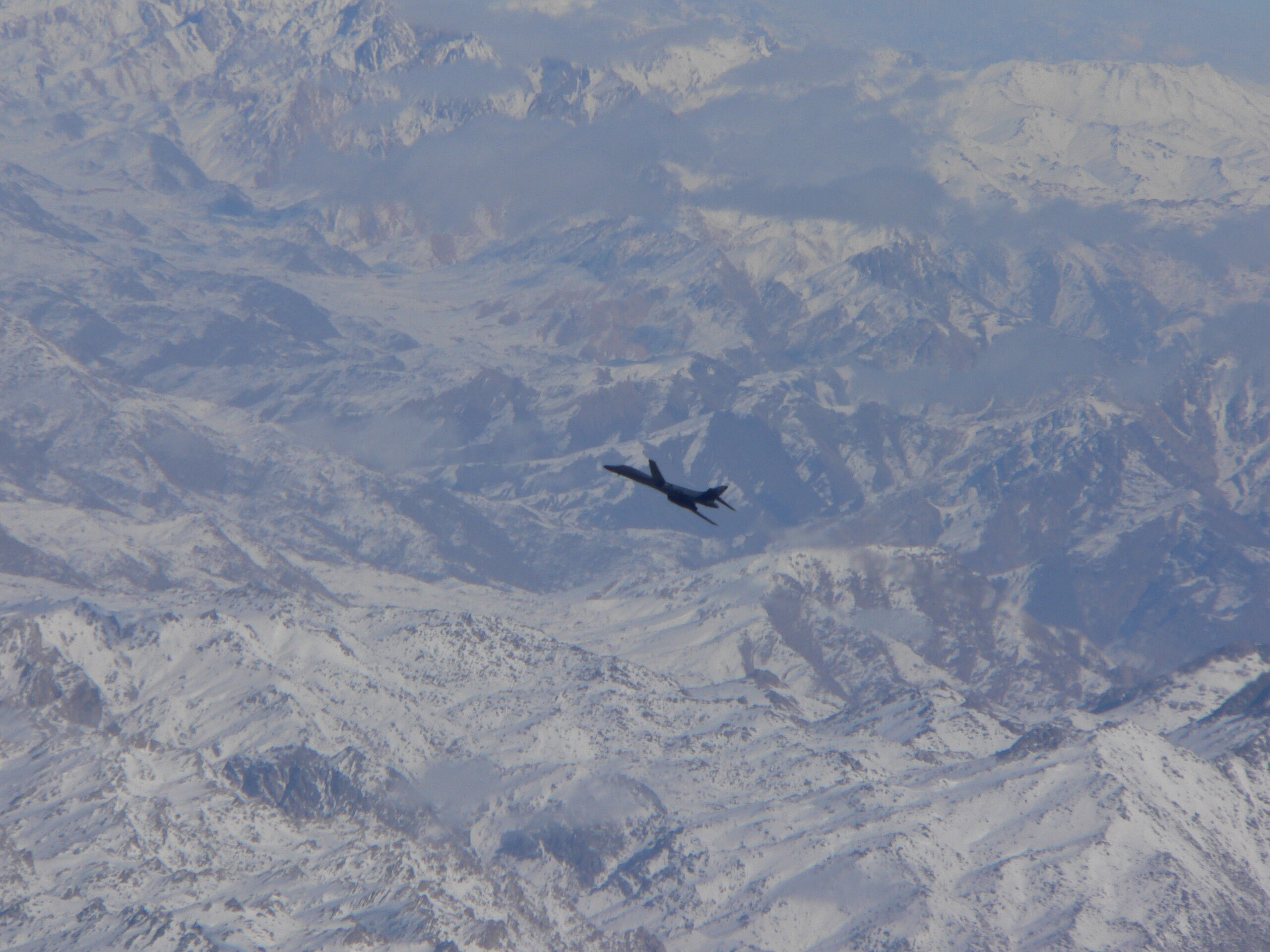
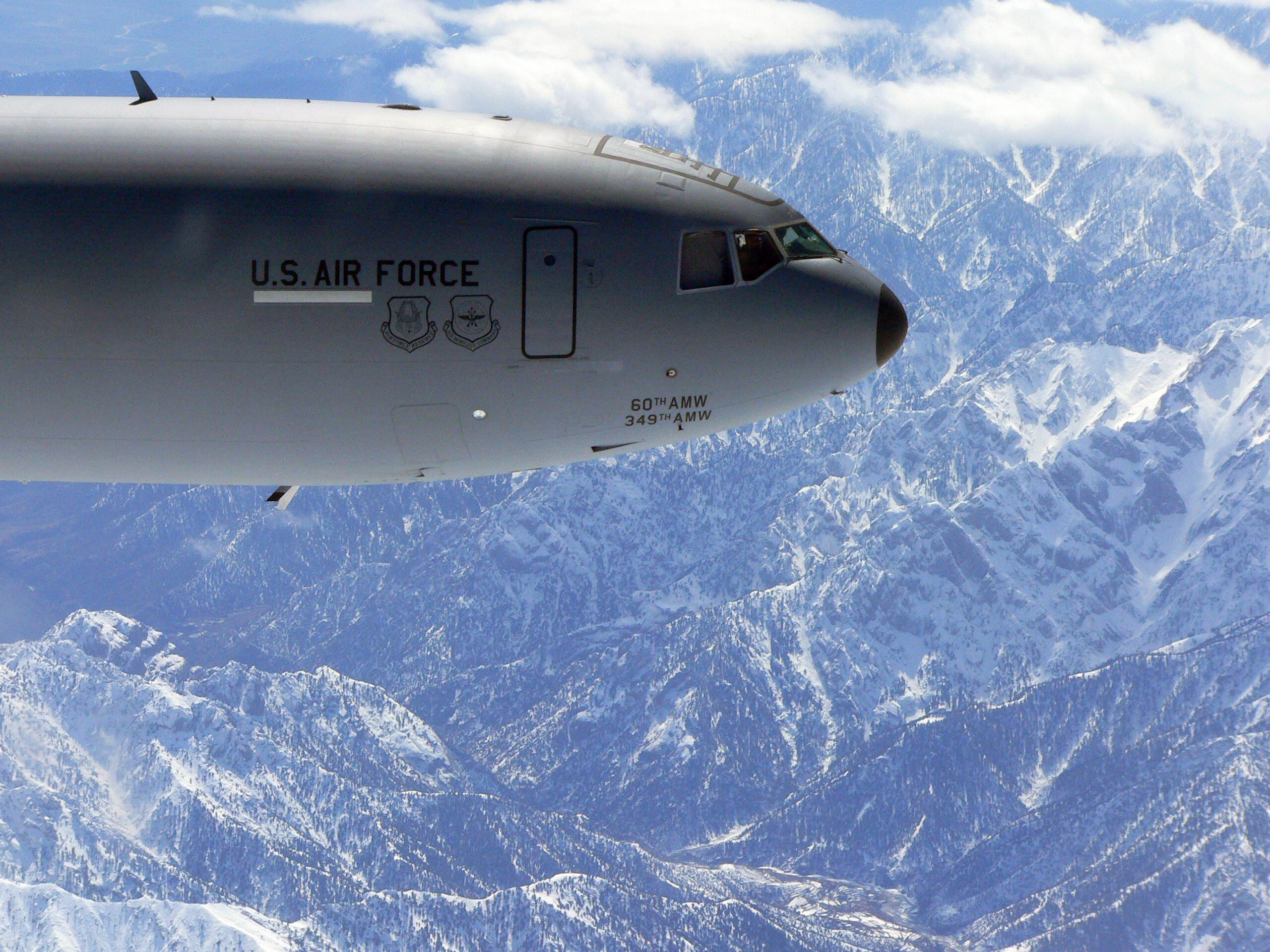
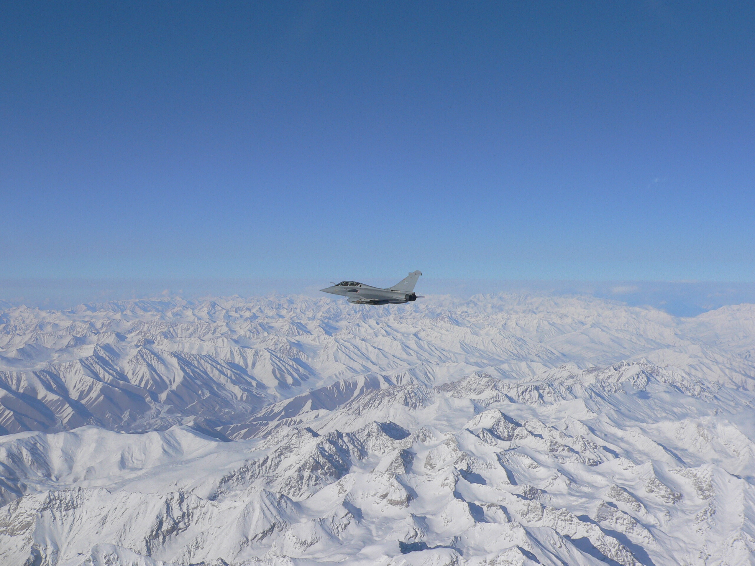
To give you an idea of the beauty of Afghanistan in winter, above are a few photos taken on a previous journey... It has nothing to envy of theaters like Kola!
-
If you are interested, there are also several official US maps for Desert Storm (and Iraqi Freedom) available online. Like this one: I turned it into .mbtiles file for those willing to use it in CombatFlite.