graveyard4DCS
-
Posts
162 -
Joined
-
Last visited
Content Type
Profiles
Forums
Events
Everything posted by graveyard4DCS
-
Hello! I'm looking for the original source of the maps used in the WWII Marianas Islands theater in DCS. If anyone can point me in the right direction... Thank you!

-
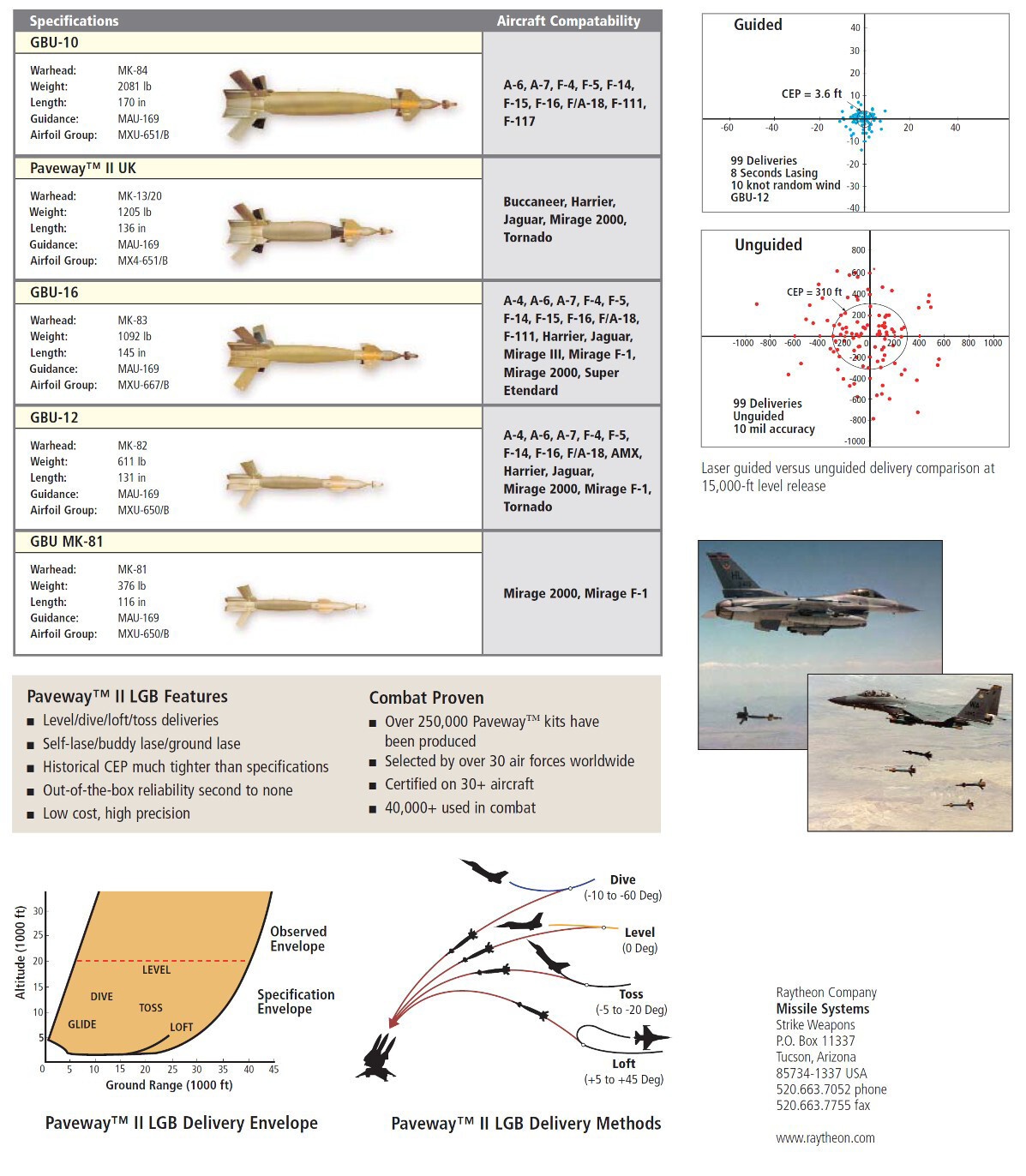
Regarding dive bombing in particular, you'll find all your answers here. The whole series of articles focuses on Paveway II, but since their ballistics is close to dumb bombs, most of it will apply to them as well.
-

Paveway II: Tactical Employment Series
graveyard4DCS replied to graveyard4DCS's topic in Guides & Tutorials
All the profiles described on this official Paveway II datasheet are described in this video. Don't hesitate to ask questions if anything needs to be clarified! For those who are curious, the tacview tracks are available here.
- 2 replies
-
- 1
-

-
- paveway ii
- level
- (and 6 more)
-
Hi, Airport charts for VFR only airfields in South and East Afghanistan have been released. Enjoy!
-
- 4
-
-

-
Tacview, the ACMI for DCS World – Official Thread
graveyard4DCS replied to Vyrtuoz's topic in DCS Modding
Hello, Sorry to bother you but I struggle with the terrain textures as detailed in your documentation. I tried to add custom textures as explained, but they appear under the default textures, and the default textures don't seem to be accessible in any folder. It seems that we can't remove them, unless by unticking the "custom textures" option, but then we get rid of all the textures, both default and new ones. The only solution is to put them in "Real World", but I wanted to use them on DCS terrain... Original textures (West) over new textures (East). Eventually, did you work on integrating geotiff pictures instead of the "tiles" that are fairly difficult to use and generate? Thank you,
-
Tacview Problems
graveyard4DCS replied to cesarferrolho's topic in Utility/Program Mods for DCS World
Hi, some servers enforce a tome delay on the tacview recording to prevent people form using the real-time tacview for better SA. You have to remain connected by the same delay after end of game to have the full track.- 1 reply
-
- 1
-
-
Over the past few weeks, I’ve been putting together a full series on how to employ Paveway II laser-guided bombs in DCS World. Even for the "basic" level delivery, I tried to include detailed description of your tasks in the cockpit. And hopefully, you'll discover new ways of dropping your GBUs, giving you more flexibility for various tactical scenarios across a range of real-world inspired delivery profiles. There I covered level, dive, pop-up, toss and loft bombing, with a focus on geometry, timing, arming delays, and how all of this ties into tactical decision-making. The idea is to help you make informed choices in planning and execution, especially in more demanding scenarios like high-threat airspace. Example of "tactical balance" study for one of the profiles. Guess which one... Each article comes with a set of kneeboard pages, built from ballistic tools and in-game testing. You’ll find release distances, time of flight estimates, impact angles, and recommended fuze settings, i.e. all that can actually help you hit the target and survive the pass. Example of geometry study of the dive profile. Even if examples are more centered on my module of predilection, the F/A-18C Hornet, any module carrying Paveway IIs will benefit. You can start here, the full index is in the introduction post (Patreon). From there, you can jump straight into any of the profiles. A usual, I'll appreciate any feedback or questions. And if you're into this kind of detailed weapon employment, there's more on the way!
- 2 replies
-
- 2
-
-
- paveway ii
- level
- (and 6 more)
-
Bomb Fuzes options in the rearming panel
graveyard4DCS replied to graveyard4DCS's topic in General Tutorials
Yes, LASER code on Paveway II and III can only be set up physically on the ground. They cannot be changed electronically from the cockpit as it was the case in DCS in the past. -
Hi, As the title says, Bost airfield (OABT) has 243.000 MHz as AI Tower frequency. 243.000 is one of the international "guard" frequencies and should not be assigned to any ATC frequency.
- 1 reply
-
- 1
-
-
Current Mission Planning Tools
graveyard4DCS replied to graveyard4DCS's topic in Military and Aviation
You're guessing wrong. Does it make any difference?- 16 replies
-
- 1
-
-
- combatflite
- fragorders
- (and 2 more)
-
Current Mission Planning Tools
graveyard4DCS replied to graveyard4DCS's topic in Military and Aviation
I'm not Russian. Just too old maybe. Just to give you a practical idea: the INS automatically computes true routes. You have to insert a local magnetic deviation in the INS to let it know the deviation to be used to compute a magnetic route. In the Mirage 2000, you check on line up that you have the correct magnetic heading, which is a way to check if the deviation has been entered correctly (eg not + instead of -). As soon as you start a visual navigation, you switch to true headings. When you set-up the plane for instruments recovery, you switch to back magnetic headings. And if you want to do an ILS, you have to insert true runway headings for ILS landings in the M2000. But the remark above is correct, BE are given in magnetic references. All GNSS systems give you true routes.- 16 replies
-
- 1
-
-
- combatflite
- fragorders
- (and 2 more)
-
Current Mission Planning Tools
graveyard4DCS replied to graveyard4DCS's topic in Military and Aviation
Every fighter pilot I guess. One of the reasons is because they plan on physical maps, and measure everything in true headings. You only switch to magnetic when you RTB for an IMC procedure. In civil aviation maybe.- 16 replies
-
- 1
-
-
- combatflite
- fragorders
- (and 2 more)
-
Current Mission Planning Tools
graveyard4DCS replied to graveyard4DCS's topic in Military and Aviation
One work-arounds with modern aircraft is to work in true headings instead of magnetic headings. In real life, magnetic headings are only used for instrument departure and landing procedures. In all other instances, true headings are the way to go.- 16 replies
-
- 1
-
-
- combatflite
- fragorders
- (and 2 more)
-
Current Mission Planning Tools
graveyard4DCS replied to graveyard4DCS's topic in Military and Aviation
Hi, thanks for your input. I agree with you, searching through the flight performance manual is time consuming, and I bet no one does it on a regular basis. If you fly the Hornet or the Hawg, you might be interested in AMVI's mission planner, it will answer you needs I believe. Personally, I'm used to making rough mental calculations which work quite well for performance (fuel vs time vs speed). And the big advantage of this method is that it remains valid in real time, since there's no dependency on external software when you're in the cockpit. But I agree that it can be useful for finer calculations, when you're within a few hundred pounds in terms of accuracy. -
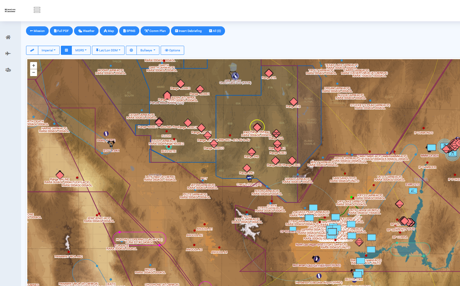
Hi, I’d like to get player's opinion on the current landscape of mission planning tools available for DCS World. The context is serious/realistic pre-mission preparation, with the goal of supporting structured multiplayer operations (up to a large COMAO level). I'm interested to hear from others: What are you currently using in single player, and in your squadron/group? What do you consider must-have features in a modern DCS mission planning suite? Here's a quick overview of the tools I’m aware of, with some notes based on experience: 1. CombatFlite Pros: The only complete standalone planner available today Unique features. E.g.: intervisibility analysis Supports import of .miz files Extensible to new theaters with basic user effort Cons: Development appears to have stalled; no updates in a long time Export of .miz files needs a lot of workarounds Still in my opinion the most complete standalone planner available today. 2. CombinedOps Pros: Web-based and multi-user capable Real-time coordination across participants ACO and ATO generation tools Free Cons: Limited set of mission planning features, not yet matching the depth of CombatFlite for detailed planning tasks Depends on active server hosting Overcrowed view for complex missions You must work from an existing flight in a .miz file 3. FragOrder Pros: Web-based and multi-user capable Real-time coordination across participant Direct editing of DCS .miz files in a web interface Cons: Limited in flexibility and detail of planning You must work from an existing flight in a .miz file 4. DCS Web Planner Pros: Free Cons: Lacks advance mission planning features No collaborative use case Depends on active server hosting You must work from an existing flight in a .miz file Thank you!
- 16 replies
-
- 3
-
-
- combatflite
- fragorders
- (and 2 more)
-
If you check my website you'll see that I published it a while ago already. And I'll keep it updated when new airfields and beacons are added.
-
South Atlantic Theater for CombatFlite
graveyard4DCS replied to graveyard4DCS's topic in South Atlantic
All three maps with elevation data and xml files with airports and beacons are now available : South Atlantic theater for CombatFlite is now up and ready. -
Now available in DCS user files. Enjoy!
-
Hi, you should start by reading this :
-
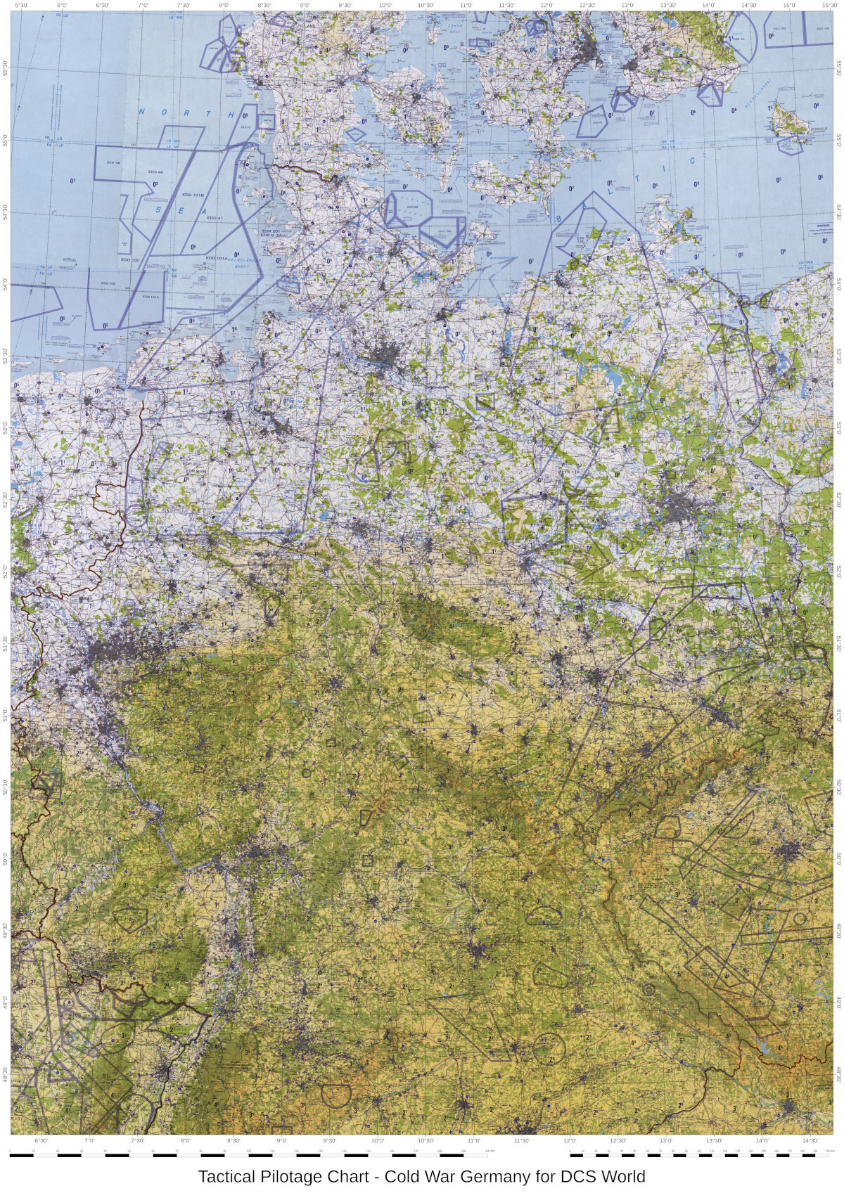
Printable aeronautical charts for Germany.
graveyard4DCS replied to graveyard4DCS's topic in DCS: Cold War Germany
The very high resolution map that is used in DCS F10 view is now available here (free membership) : Enjoy!
- 1 reply
-
- 1
-
-
Hi, Can we have an update on this bug? 3 years later, it's still the same status: GBU-12 and GBU-10 can be lofted and tossed with the F/A-18C, but GBU-16 is still very long and never gets the LASER spot. Thank you,
-
Operation Bakwa Hammer - A Runway Strike Mission
graveyard4DCS replied to graveyard4DCS's topic in Missions and Campaigns
If you’ve tried to fly Operation Bakwa Hammer and found yourself wondering how to approach the attack profile, manage fuel, stay on timeline, or navigate the threat environment, I’ve put together a detailed step-by-step breakdown of the full mission planning process. It’s based on a logical structure as it can be used in real-world aviation, adapted to the context of DCS. The write-up goes through all the key planning phases: Feasibility (fuel, timing, weather) Tactical and threat analysis Full 4T study (Task, Target, Threat, Tactics) Route and waypoint design using visual navigation techniques Fuel planning (JOKER, BINGO, push fuel, etc.) Contingency management etc... The goal is to offer a clear and practical framework that helps make complex missions more manageable — particularly when flying alone or with a small element in high-threat environments. It’s not meant to be “the” way to plan, but it should provide a useful reference for anyone who wants to approach their missions with more structure and intent. Enjoy! -
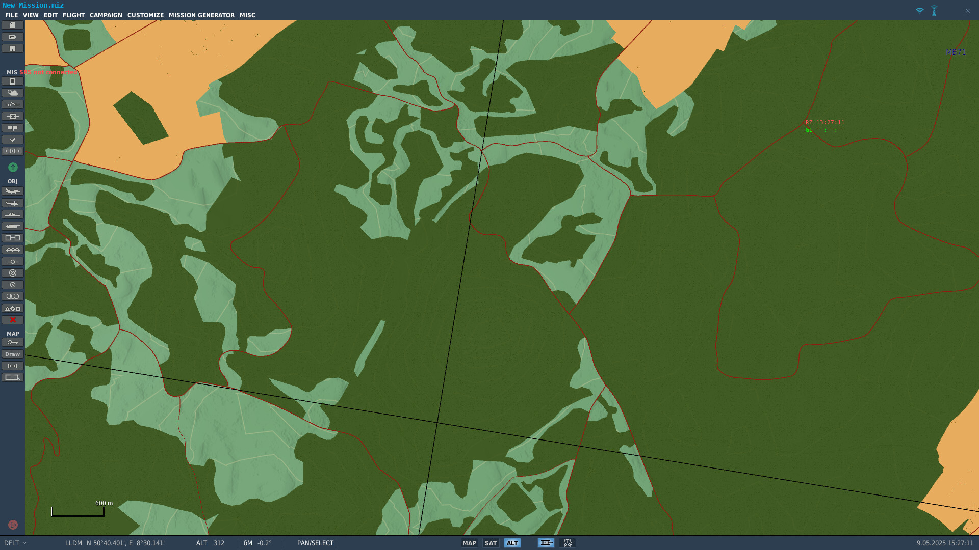
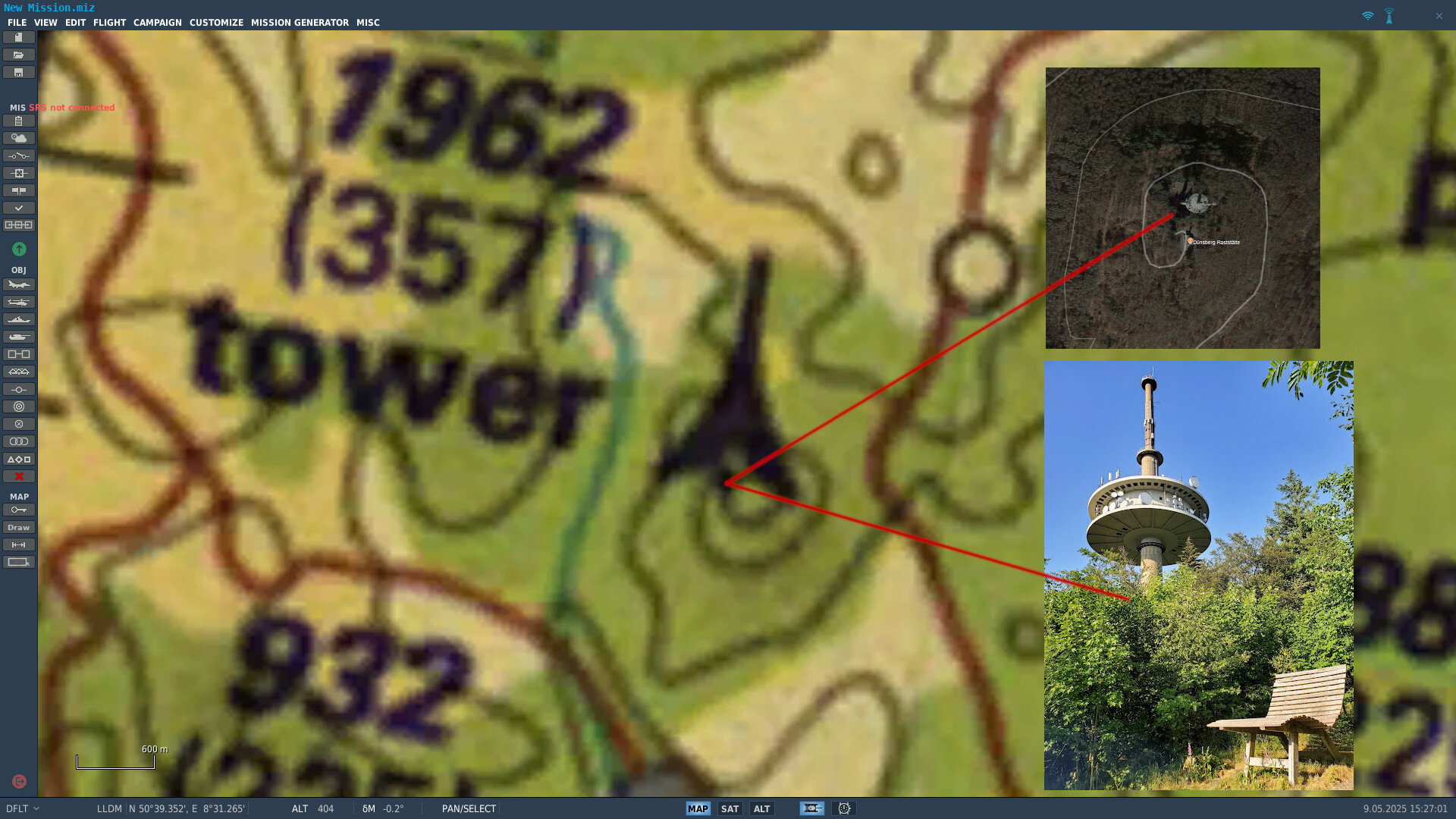
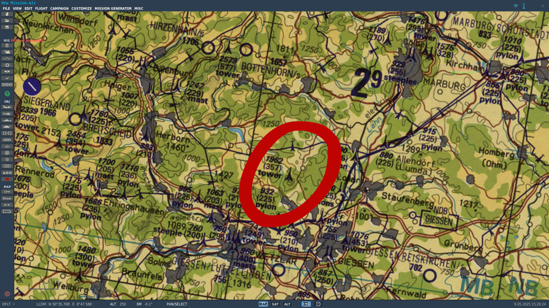
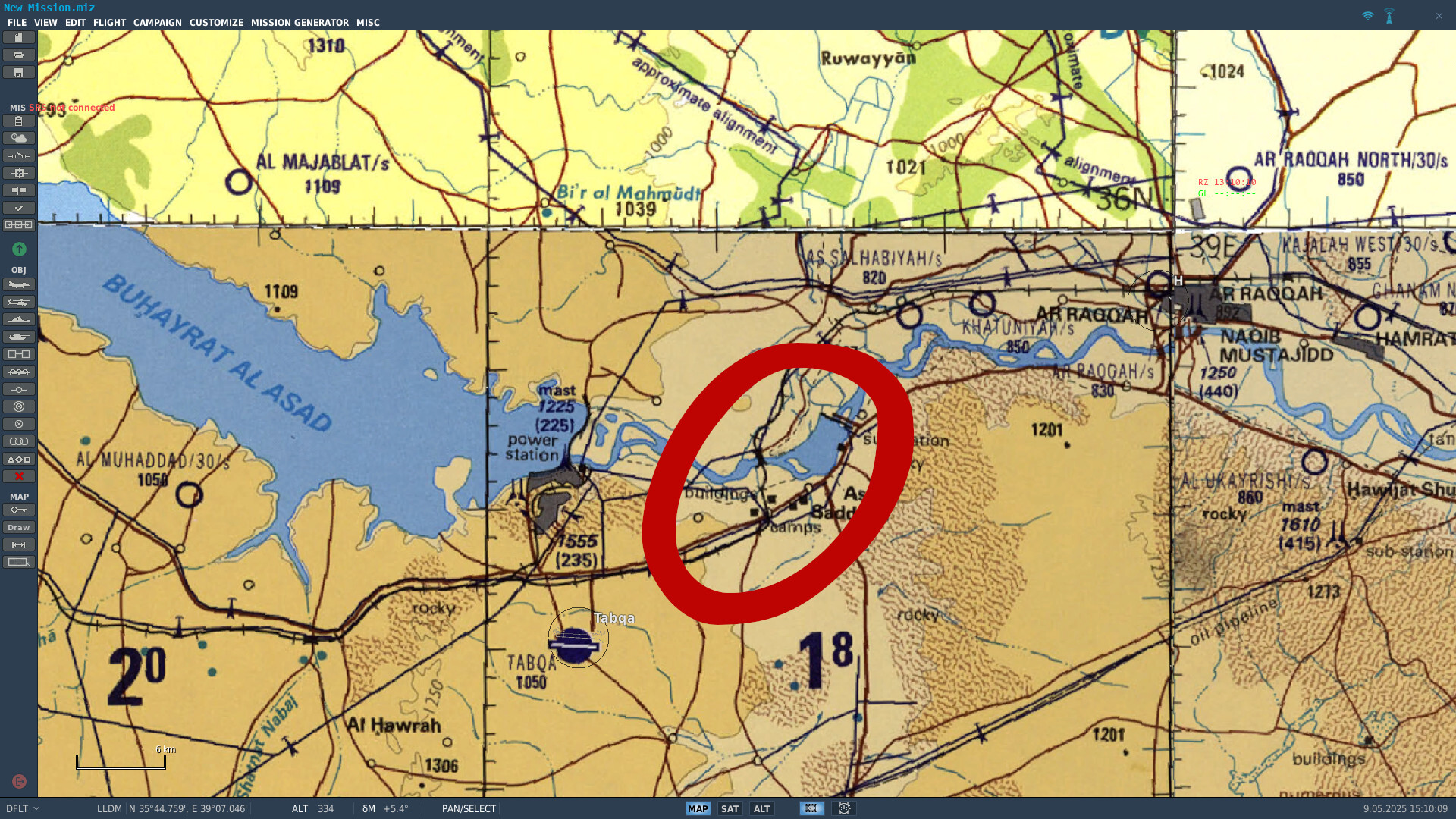
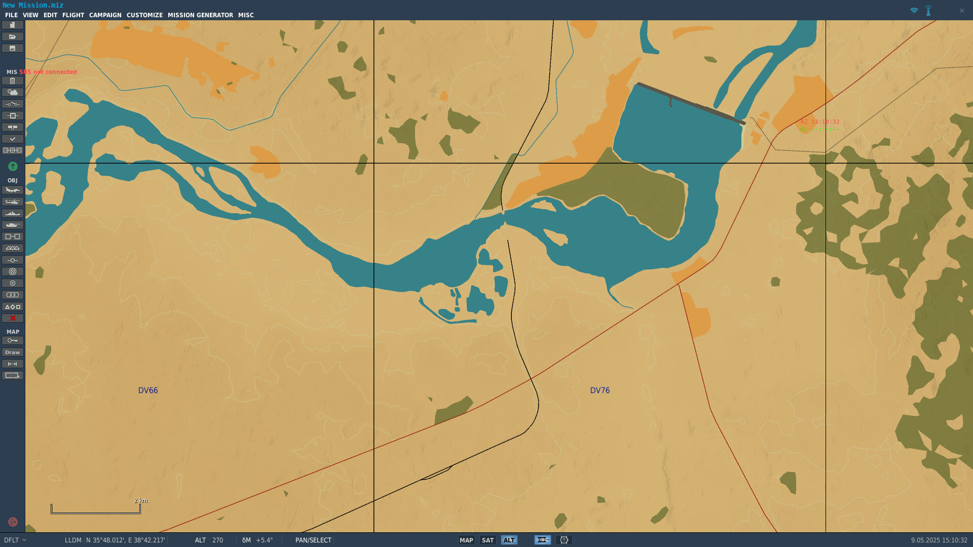
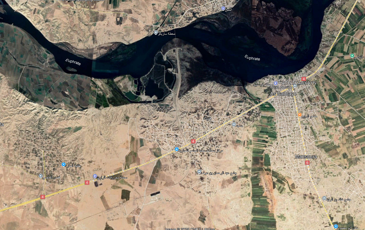
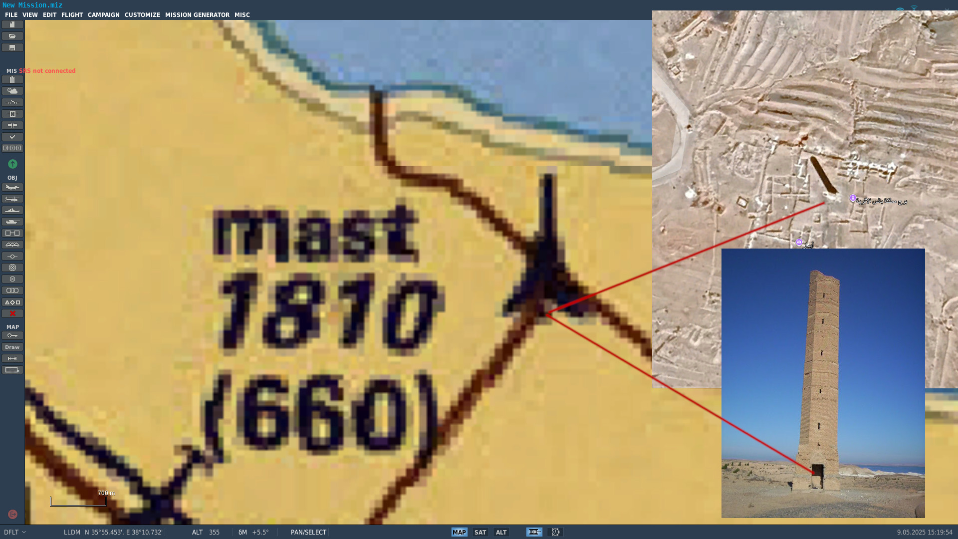
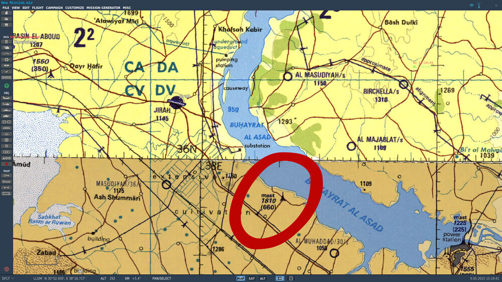
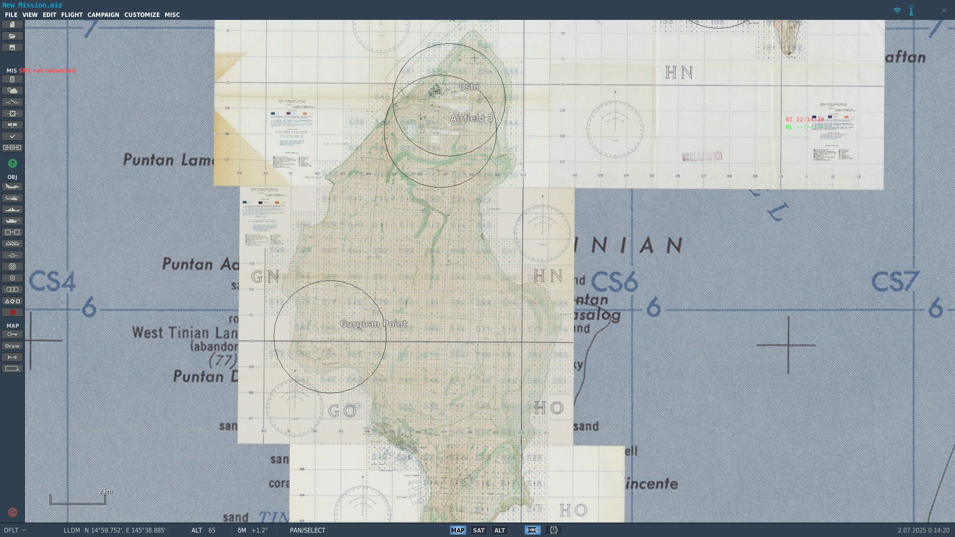
Dear Ugra Media Team, First of all, thank you for your continued work on providing new theaters. I’d like to raise a terrain-related issue that affects all maps in DCS (not only yours) and has a critical impact on mission planning and visual navigation: DCS currently displays Tactical Pilotage Charts (TPCs) as the base map layer in the Mission Editor and F10 view—but the actual in-game terrain does not reflect the contents of this chart. This is not a minor discrepancy. Entire features visible on the TPC—towns, roads, airfields, railways, dams, power lines, smokestacks, vertical obstructions—are completely missing from the terrain. This breaks both immersion and function for players who expect the TPC to be an authoritative reference, as it is in real-world aviation. This is the key point: DCS is explicitly showing the TPC as a reference map, which implies that what you see is what you get. But that is not true in practice. Pilots and mission creators plan based on that chart, only to find that key features simply do not exist in-game. We are not concerned if some features exist in-game and aren’t on the TPC chart. The concern is the opposite: if a feature is shown on the TPC, it must exist in-game. Examples of missing TPC features: Towns (even large ones) shown on the chart, but no buildings or textures in-game. Roads and railways that appear on the chart, but do not exist in the terrain mesh. Dams, bridges, smokestacks, or power lines visible on the TPC but entirely absent from the map. These are not minor decorative details—they are tactical elements for low-level visual navigation, mission timing and leg planning, target area identification and IP selection, and obstacle avoidance. What we’re asking: We understand this is not a trivial fix. But we ask for a long-term, map-by-map effort to bring terrain data up to par with the TPC reference layer already used in the Mission Editor and F10 view. Specifically: If a feature is shown on the TPC, include it in the terrain. Start with key navigational aids and obstacles: roads, towns, power lines, railways, airfields, vertical obstructions. This would greatly improve realism, usability, and trust in the mission planning tools provided within DCS. Why this matters: You chose to display the TPC chart as the reference map in both mission planning and live operations (F10). That choice is excellent—but only if the game world matches it. As it stands, the chart becomes misleading, which hurts gameplay and immersion. We’re not asking here for new assets or visual upgrades—we’re asking for basic terrain consistency with the chart DCS already uses. Thank you for your time and consideration! Examples: Old Map - Syria The railway bridge is missing, as well as all the villages to the south. Other example: very large mast/tower missing. New Map - CW Germany No large antenna.
-
- 2
-
-
Hi, A first modern VFR ICAO chart for Germany has been released in ED user files. The TPC map used in DCS F10 map will be released shortly! Note that both maps are also available in .mbtiles format for CombatFlite.
- 1 reply
-
- 4
-
-
-
Cold War Germany Theater for CombatFlite
graveyard4DCS replied to graveyard4DCS's topic in DCS: Cold War Germany
Rename to theaters.xml and replace the original file. Please watch the video above to find more answers maybe?- 4 replies
-
- 1
-
-
- combatflite
- cold war germany
- (and 2 more)
.jpg.a9e535867eebfb3bcbf43d50077189f8.jpg)
.jpg.6a2f727dcbb0a6c89e59d5c10b686f81.jpg)
.jpg.9b30b61210332f7a2a8ae2a758948abc.jpg)


.jpg.815da27bfeefaefae5d97818bede2ad5.jpg)
.jpg.3d1f4101afcf0e83831f17159c020a4f.jpg)
.jpg.4293ad30c62ed35fb18e479484c1c8fc.jpg)