Hog_No32
-
Posts
496 -
Joined
-
Last visited
Content Type
Profiles
Forums
Events
Everything posted by Hog_No32
-
Keep in mind the alternative to the HALF and FULL switch position is labelled AUTO (instead of OFF or UP) for a reason. If you watch the LEFs movement (TEFs are harder to see from the cockpit) during maneuvering you‘ll see flight computer in action. The TEFs are also extended when the computer feels the additional lift is what the pilot is demanding but (I‘m guessing here) they likely will not extend to full deflection when above 250kts due to the high stress and excessive drag. Btw this is a feature any highly maneuverable 4th and 5th generation fly-by-wire fighter aircraft has.
-

Hard time Dogfighting MiG-15, F-86 and M2000
Hog_No32 replied to GrEaSeLiTeNiN's topic in DCS: F/A-18C
That‘s a neat idea and a nice workaround! I‘ll give that a try (even though my dogfighting skills are really low still since I’ve spent 99% of my DCS time in the mud mover business so far. But that is changing a bit with the hornet now :smilewink: ). Thanks -
Not for me. I updated and refueled fine behind the S-3 just moments ago. No strange behaviour observed. I flew a self-made mission in PG though, not an instant action mission. Just saying the S-3 itself seems to be ok. (and all that with a 10 year old TM Warthog...:music_whistling: cheers, Flamin :smilewink:)
-
A great feature for DCS mission building would be the possibility to have barrage AAA fire. By barrage I mean some kind of unguided, random AAA fire that could be activated by a trigger. Basically to remodel a sky that looks similar to the famous CNN footage of Baghdad in the first nights of the 1991 gulf war. Something that scares the sh*t out of you when you have to fly into it (which is what I recall some British Tornado pilots told after their first sorties...) :)
-
As Doum76 already said: We know the tanker goes neither supersonic nor does it fly at the speed of a C172. Regardless of the type of tanker aircraft we can expect an IAS in the range of 200-300 kts for most of the altitudes. Knowing that should be absolutely sufficient to intercept it properly. It‘s about judgement derived from experience. Sure you can compare numbers and your GS with your IAS, there is nothing wrong with that. But I personally don‘t think you need to do. The only number I look at when outside of the visual range is the TACAN range. The speed at which this runs down gives me a good idea of my closing rate.
-
very well put. Indeed, AAR is nothing but a visual thing. You don‘t make it happen by looking at your altitude, speed or heading. You just look at the tanker to judge and adjust your closure rate and position. Nothing more. And as everybody keep saying: practice, practice, practice... keep the throttle moving...ignore the basket....and it will come.
-
Very well summarized, Mad Max2!:thumbup:
-
[FIXED with HOTFIX 3] 2.5.3 openbeta crash(Nevada and Persian gulf)
Hog_No32 replied to Sonoda Umi's topic in Game Crash
same issue here, DCS hungs up when loading a PG mission both in ME as well as when selecting a PG mission to fly it. Interestingly, it all worked fine yesterday right after I updated. I flew one PG mission and I believe I also edited it before in the ME. The mission went flawless (except the missing TACAN data in the HSI). I then shut down DCS as usual and went to bed. Tonight I fired up the DCS again and now I have the problem. I didn‘t change anything in between. Updated my nvidia driver and did a DCS repair. Still doesn‘t work. Tried Caucasus and all works well. Running on Windows 7. -
True, I still don‘t get why you compare apples with oranges. I don‘t get why you can‘t answer my simple questions with 30+ years of experience...and an instrument rating! But I agree with you that it appears pointless to continue this discussion. Good night.
-
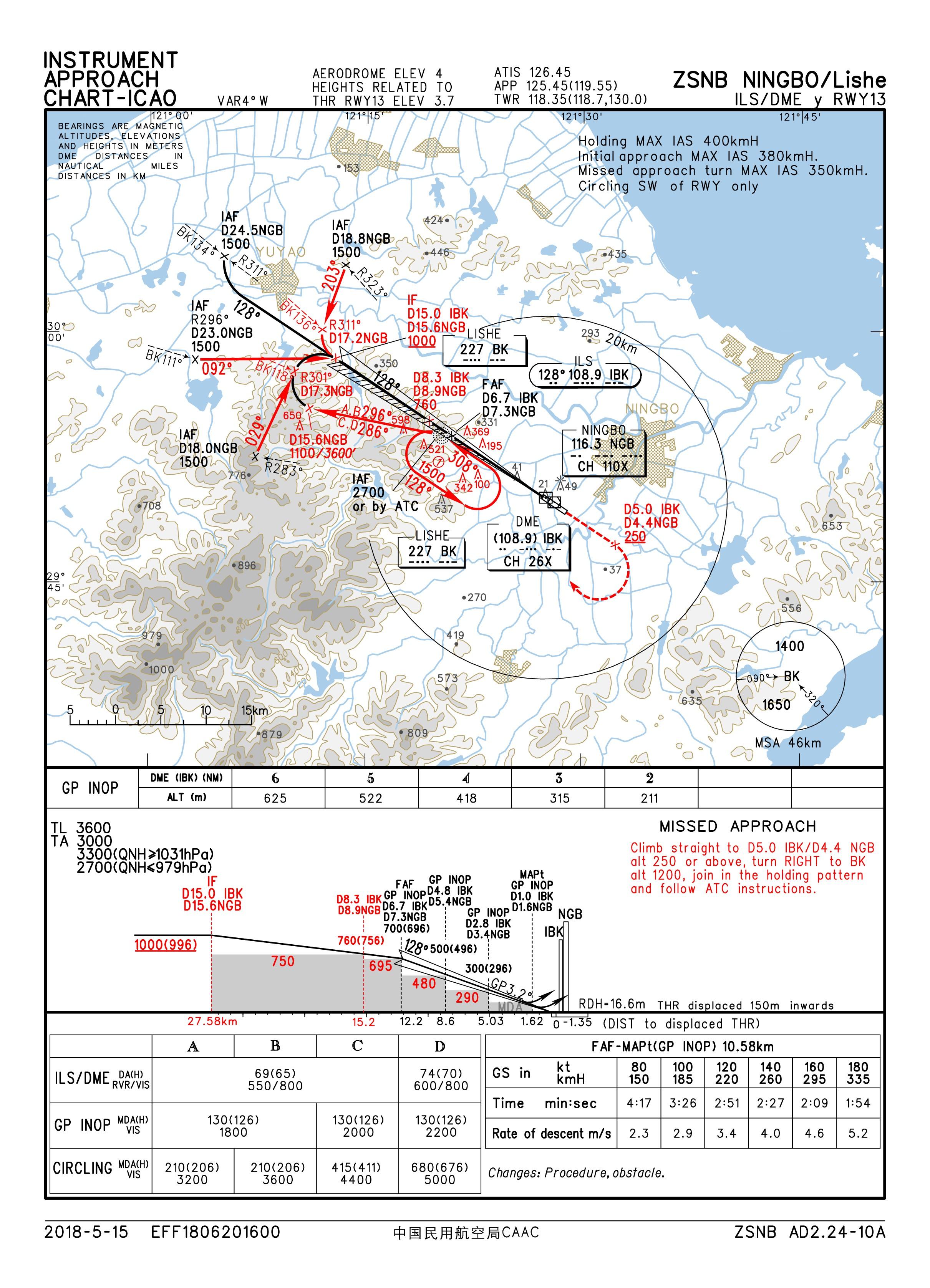
And how does the Jeppesen chart legend apply to the Chinese AIP charts? Apples and oranges. And DH is not shown in the profile view anyway, neither on Jepp nor in Chinese AIP charts. You don‘t even need the Chinese chart legend since the meaning of the heights is explained in the headline. Which you again prefer to ignore.
-
Finally you begin to really really read the charts, great! So, then I am asking again since you didn’t answer that: When it is true what you say and the altitudes/heights in brackets really correspond to heights above ground that you read off of your radio altimeter, how comes the difference between these heights and the barometric QNH altitudes (thise without brackets) is consistenly 4 meters all the way through the approach despite the fact that the terrain below the approach path is anything but flat?
-
Ok. I see. I quote official government regulation as proof. All you came up with is „I do this for 30 years and I am still alive“. That speaks for itself.
-
That is not a proof. You are not source. Show me a regulation that supports your thesis. Bro, you even demonstrated that you can‘t interprete the altitudes provided on a Chinese AIP chart. Also you seem to confuse radar altimeter readings with QFE all the time which have nothing to do with each other. Looks like those 30+ years in a bubble...
-
LOL, someone under FAA jurisdiction is pointing out to PANS-OPS. Really, you are making my day. Ehm, and you certainly can tell me why you believe that the Chinese regulation which I quoted applies to VFR only, can‘t you?
-
Bro, that is YOUR SOP (obviously at FedEx). I have no doubt that you know that better than me and I have no doubt that you operate legally and correctly and safely. The point which I am trying to make is that YOUR SOP with YOUR operator in YOUR country accepted by YOUR regulator is completely irrelevant to anybody outside of YOUR company, YOUR country and outside the jurisdiction of the FAA. You claimed „China is all QNH“ and I clearly proved you wrong on the „all China“. Otherwise, why the section 2.2.2 in ENR 1.7? You claimed QFE is not used by ATC in UK which was proved wrong by three other forum members. Still you believe you know it better. My last post here. It is pointless to explain regional specialties to someone who believes the whole world works like the United States.
-
After todays update to the OB version, I am lacking distance and bearing information on the HSI when selecting a TACAN. True for both ground(ship)-based TACANs as well as airborne (tanker). Range and pointer are correctly displayed on the HUD. The ETE is also displayed in the HSI at the usual location but no bearing or distance. Worked flawless before the update.
-
You realized the chart is from China, documents a Chinese procedure and that we were talking about local/regional procedures to fly that approach in China? What that has to do with what is legal in the US is beyond my understanding. Again, plain wrong, sorry. Look at the chart again, these are not radar altimeter heights. There is higher terrain under the initial and intermediate approach. A radar altimeter height would tell you the height above terrain below, right? So how comes the numbers in parentheses are consistently only 4 meters lower than the numbers without parentheses all the way to the runway? With changing terrain elevation below you you would expect to see a variance in the difference between barometric altitudes and radar altimeter heights. The numbers in parenthesis are altitudes QFE meaning they are in reference to the threshold elevation (which surprisingly is 4m above MSL). Just what the chart says in its headline but it appears you decided to ignore that.
-
not official but you may want to give this a try (see 2nd post): https://forums.eagle.ru/showthread.php?p=3609710#post3609710
-
Bit OT but that is actually another bug I think. IIRC in the past (can‘t say until which update) we used to have both commands „Open formation“ and „Close formation“ available at the same time regardless of the actual formation flown. Now, initially I only have „Open formation“ available after a mission start.That despite the fact that open formation is the default formation flown. I have to command „Open formation“(F8), AI wingmen acknowledge but don‘t do anything else since they already are in open formation and only then I get the option to command „Close formation“(F9). AI wingmen then correctly move to the close formation.
-
My point is there are more countries than just Russia that use QFE in procedures and publications. Not necessarily for all airports and all types of operations/airspace users but for some. That was all I wanted to say. Sorry, but that is not correct. Look at the headline of the sample chart I attached. It reads "heights related to THR RWY31 3.7M". Dial in QFE in your barometric altimeter (never talked about the radar altimeter and it has no relevance on the topic so I don't get why you mention it) and fly exactly those altitudes on the charts (provided you have a metric altimeter). What's the problem? You are perfectly safe and legal. Any by the way: Whether a commercial B777 or a Cessna pilot, you ARE legal to fly with the AIP charts (in the issuing country). That is the whole point of AIPs. Having a globally standardized chart set from a commercial provider like Lido or Jepp is not a legal requirement. Their business case is the standardization part which makes it easier for crews operating globally where they otherwise would be exposed to various different AIP formats, fonts, colors etc. That is where Lido or Jepp or NavBlue (to be complete) comes into play. The fact that 99,9% of all commercial operators fly with commercial charts does not say it would be illegal to fly with AIP charts. Congrats on your flight hours (seriously, no sarcasm here).
-
Very nice, thanks pimp! Tried it out last night and got my AI wingman to hit the tanker (KC-130) after I refuelled. Unfortunately, he stayed connected forever. He never disconnected from the tanker and he never rejoined me. I was flying in formation with the tanker and my buddy connected for more than 10 minutes when I realized something is not right. It took me not more than 5 min to get filled up so I wondered why it takes that much longer for him. Since nothing worked I decided to leave him at the tanker and finish the mission. I landed 35 min later and he was still on the tanker at that time (which also tells me fuel was transferred, otherwise he would have run dry in the meantime). Anybody experienced something similar?
-
Further from AIP China ENR 1.7 Altimeter Setting Procedures: 2.2.1 At aerodromes where transition altitudes and transition levels are established: QNH shall be used for flights at or below the transition altitude specified in the aerodrome Altimeter Setting Regions; 1013.2hPa shall be used for flights at or above the transition level. 2.2.2 At aerodromes where transition heights and transition levels are established: QFE shall be used for flights at or below the transition height specified in the Aerodrome Altimeter Setting Regions; 1013.2hPa shall be used for flights at or above the transition level. So just flying to one airport (Beijing) might not tell you the whole story for the entire country. Just like Flamin_Squirrel wrote: QFE is used during GA VFR flights in the UK while everbody who flies to Heathrow know they're using QNH there.
-
You may want to read my post again: I said they publish procedural altitudes as QFE (height related to threshold elevation) for approach procedures. I did not say the use those in ATC clearances (which you may be exposed to) and obviously you don't see these heights in your commercial chart sets. But if you would use the AIP plates (which would be legal) you would work on QFE for approaches. See attached sample chart. Which is just what I said, right? And it is just why you are not aware in what form they publish their altitudes in AIPs. QFE instead of QNH as the altitude reporting reference (including ATC phraseology) is currently standard in Russia, Kazakhstan, Belarus, Tadjikistan, Turkmenistan, Uzbekistan and Kyrgyzstan.

-
What new feature of the Hornet are you most looking forward to?
Hog_No32 replied to Wags's topic in DCS: F/A-18C
my top 3: 1. HARM 2. HARM 3. HARM -
Thanks Flamin_Squirrel for taking the time to explain.