dcs76
-
Posts
158 -
Joined
-
Last visited
Content Type
Profiles
Forums
Events
Everything posted by dcs76
-
[FIXED] HUD: A picture is worth a thousand words?
dcs76 replied to randomTOTEN's topic in DCS: A-10C Warthog
I fly in VR and experienced in all of the VR headsets I tried (HP Reverb, Oculus Rift, Index, Oculus Rift S) the same issue that I cannot see the full HUD symbology at any given moment - neither on the ground nor in the air with the default view point. I have to move my viewpoint waaaay down and waaay forward in order to see the full HUD. At this time I basically bump my nose at the UFC and I sit so low that I am unable to do a proper 30DB (or steeper) delivery as the targets sitting on the rail would give me a 20° dive angle reference. The initial viewpoint position is more or less properly aligned (top of the HUD frame as thin as possible, nuts on right side aligned) and this is also perfect for the proper dive angle referencing (target on the rail for 45DB), so I am reluctant to change my viewpoint. This however results in me only seeing the lower half of the HUD symbology and only half of the text on the left and right side at that. It requires me to constantly move not only my head but also my full upper body around quite extensively in order to see all the HUD symbology and numbers. After tip in, I have to lean forward and duck my head down to do a proper attack. In my opinion, the HUD projection is way too large so that it cannot fit into the HUD projection frame properly. I would also like to have this issue resolved - not only for 2D, but also for VR players. -
This video was recorded in 2015. I tried repair and also tried to reinstall the campaign without success. Same outcome.
-
In the attack brief, Uzi states to mark the first target with laser. When IP inbound Uzi suddenly says no mark and does not clear hot either. I did multiple IN calls from given FAH restriction and from all other directions. I got a lot of abort calls. I had to let Uzi repeat the brief before I could finally call IN and get a cleared hot. However I had to self lase as Uzi was still not providing a laser mark. The second target (APC) was supposed to be marked by WP. However, again when calling IP inbound, Uzi did not put the mark on the deck. I just got a continue and nothing else. I could not even call the IN. Also the FAH restiction was given as 180 to 185. For a low angle strafe with the gun, this is quite impossible as I would need to leave the MOA for getting the proper angle. So the mission stuck there. In several attempts the IP finally called it of due to time restriction and sometimes I reached the MOA edge and received a KIO because I could not get to the given FAH for a proper gun run.
-
I'm pretty sure, setting steerpoints for carriers, awacs, tankers works only for AI units. Can it be used to set a whole flight plan for a player controlled aircraft? I'll have a look.
-
I have a multiplayer server mission template with lots of airplanes, but now flight plans/waypoints set for those airplanes. As a client, whenever I connect to this server and enter a cockpit, the waypoints should be set for that aircraft. The waypoint data is outside of the miz file - say in a csv or lua file. It is ok for me to either load the waypoint data on client side or to load it on server side with the event of a client taking a slot. IF it is server side loaded, the waypoint data to be loaded could be based on the player name or the aircraft the client takes. Is it possible with a client side mod or server side scripting to do this? (I know of solutions which basically take a waypoint list and load it into the aircraft by automatically pressing the buttons and switches to program those waypoints. However, this requires the aircraft to be in a specific state (powered, CDU/flight computer ready to be programmed) and the client has to wait for the script to do its job. So I know how this works and this is not how I want to do it.)
-
I recently stumbled upon something we could not explain: The wind corrected Desired Magnetic Heading indicator in the HUD (below the heading band) is a little mistery to us. I originally thought that whenever the FPM is alligned with the steerpoint on the HUD, the heading "needle" should be aligned with the DMH as well. This is only the case, however, if there is no cross wind. When I align heading indicator and DMH while having a cross wind component, the steerpoint is not centered in the HUD. Yes the FPM is to the side as I would expect it, but the steerpoint is to the other side - not centered. Maybe this is a bug in the A-10C and the DMH is not correctly calculated. I found an old bug report in the forum, which might be related.
-
Well thanks for the explanations. I can say that I already knew most of it ;-) I would like to point out that although the AOA is measured based on the wings chord line, we are still talking about a FIXED wing aircraft which means that the angle between the wing chord line and the aircraft fuselage does not change. I understand now that the AOA indexer shows arbitrary units, but I would still like to know whether it's possible to convert the unit shown by the AOA indexer to actual degrees or mils. Is this a logarithmic or linear scale? The reason I ask is, that I would like to calculate/verify the calculation for the pipper depression for manual bombing and I have to take into account the angle between the flight path (aim off distance / aim off point) and the point where the nose of the aircraft is actually pointing at.
-
I am doing a 45° DB. Altitude is 6000. speed is 350 KIAS. The FPM is about 1° below the 45° pitch ladder, the ADI shows 45°. TacView shows 45° Pitch and an AOA of about 1°. I am pretty much wings level and have the expected g-load. The AOA Indicator in the A-10C, however, shows a value of 11,2. I am honestly confused about the units the AOA indicator is using. This can't possibly be the AOA in degrees. It also cannot be in mils as this would be about 0.6° AOA. It is supposed to be in ° as far as I understand. The limit markers on the AOA indicator do also hint at the units being degree. So why would the AOA indexer show me a value of 11 for this? Am I doing something wrong?
-
Too bad this is not yet available. We also do very much need this functionality. Our use cas is that we have a template mission with client aircraft. Two times a week we practice. Sometimes it's dive bombing, sometimes rockets, sometimes more advanced stuff. We use a tool upfront to define our mission flights, flight plans (waypoints) as well as targets and weapon profiles. This tool generates Mission Data Cards which we load into our kneeboards (ingame or VRK). After entering the pits and loading weapons, the tedious part of programming the flight plans as well as weapon delivery profiles starts every time which takes a huge chunk of our available practice time, before we can even takeoff. IRL those flight plans and weapon profiles would already be preplanned (like we do it) and automatically loaded from the DTC. So we would very much appreciate this feature. It would allow us to at least have an F10 menu to initiate the programming of the CDU and DSMS after starting the aircraft up to this point. The best option would be of course if we could just place the DTC data somehow in a file and it would be loaded right when we click the LOAD button on the MFCD.
-
VRK - a virtual reality enabled kneeboard with touch and ink support
dcs76 replied to AMVI_Rider's topic in DCS Modding
Hi there. Great tool! I love it so far. One thing I noticed, though, is the page size. All diagrams and charts I can download from websites like AirNav have a page size of 137 x 210 mm. This seems to be the standard kneeboard page size (at least in the US). The page isze in VRK seems to be wider though which results in a "fat" picture of all those diagrams/charts as the width is stretched. Would it be possible to have the page size being defined so that it matches with this format? -
Nun ja, wenn es diesen Flughafen IRL gäbe und er ILS hätte, würde man dafür auch Verfahren finden. Nur gibt es IRL den Kobuleti Flughafen so nicht und nicht mit ILS.
-
Und hier noch was für UGKO: http://airnav.ge/ais/pdf/AIP%20SUP_02_2012.pdf
-
"Kobuleti Airfield" ist IRL das Kreuz. Da wirst du nix finden. Das Kobuleti Airfield in DCS heißt IRL "OZURGETI AIR BASE". Der Flughafen hat aber keine ICAO Kennung und kann meines Wissens nicht für IFR Approaches genutzt werden. Kopitnari (ICAO: UGKO) und BATUMI INTL (ICAO: UGSB) sind die beiden Airfields in der Nähe, die dafür in Frage kommen. Für UGKO findest du hier zum Beispiel einiges an Procedures: https://vau.aero/navdb/chart/UGKO.pdf Und hier für BATUMI: https://vau.aero/navdb/chart/UGSB.pdf VG von einem eurer Ex-Piloten ;-)
-
NTTR info and mission by the 476
dcs76 replied to Stuka's topic in DCS: Nevada Test and Training Range
Great work! One question though: You have quite a few navpoints defined in the mission file. Some of them can be found with their coordinates in the AFBI Nellis document, so I suppose you took those coordinates from there. However there are a lot of navpoints which I could only find in departure or recovery charts as DMEs (e.g. RYANN). Where did you get the exact coordinates of those points? I could not find any official source for those points. Did you just measure the DMEs and placed the points there or did you have other reliable sources for those points? -
[WISHLIST] New A10C suite as a Paid upgrade
dcs76 replied to falcon_120's topic in DCS: A-10C Warthog
Yesterday NineLine confirmed on ReddIt that there will be a paid upgrade for the A-10C. He did not specify what will be in it though. -
[REPORTED] High-quality A-10C cockpit switch logic
dcs76 replied to Redglyph's topic in Controller Questions and Bugs
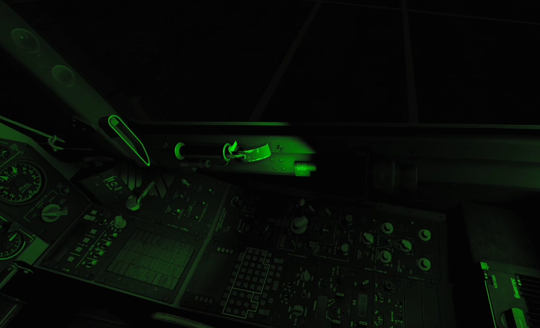
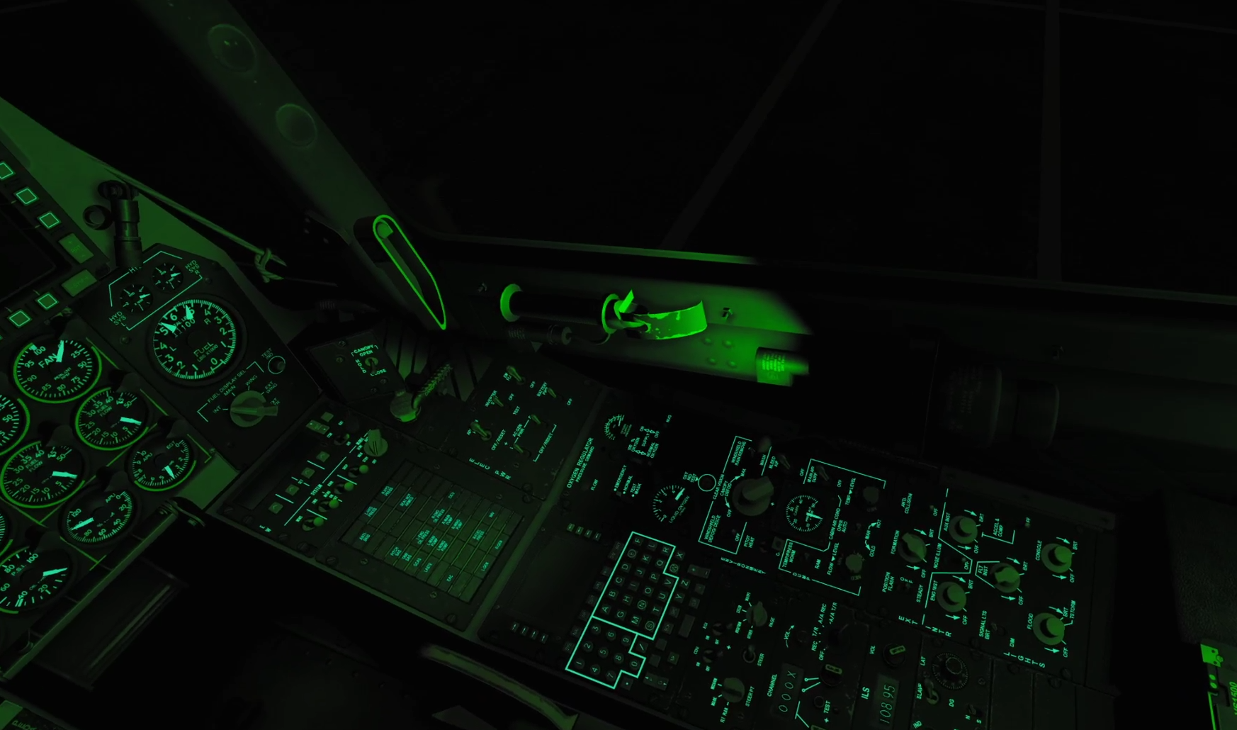
Here a few more pictures for comparison. - Only flood light and canopy closed - Flood light and max interior lights with canopy closed
-
[REPORTED] High-quality A-10C cockpit switch logic
dcs76 replied to Redglyph's topic in Controller Questions and Bugs
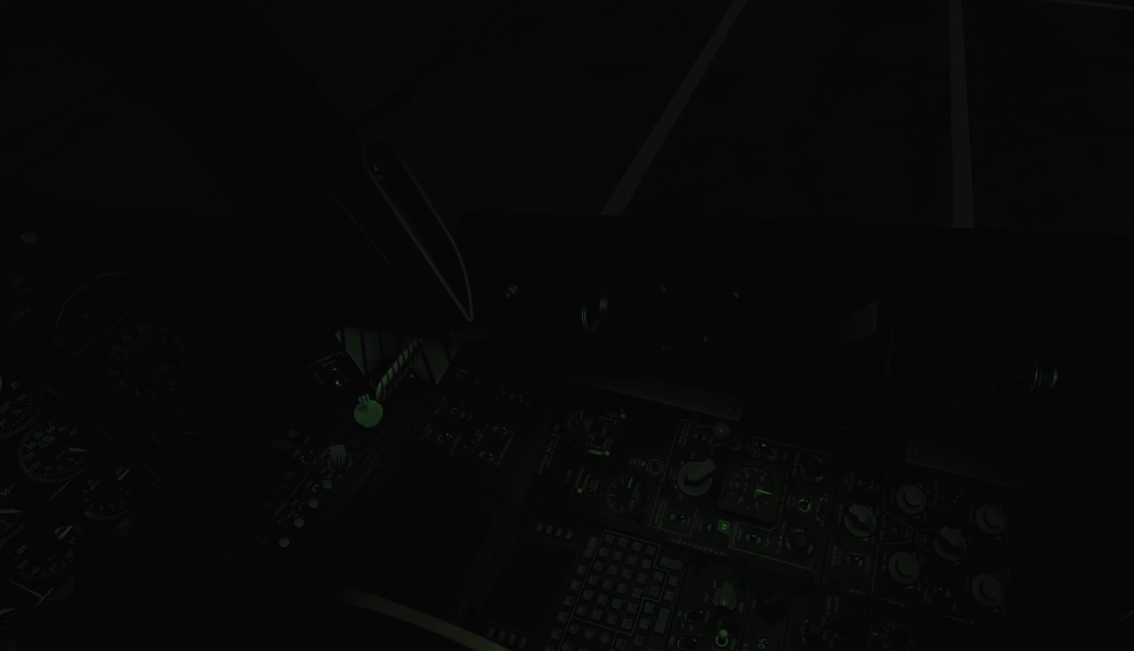
The lighting is very dark. Especially in VR at night - I am faced with total blackness and am even unable to find the emergency flood light switch. Even after I enabled emergency flood light, the other buttons cannot be found like it was possible with the old cockpit. gamma is at 2.2. See attached screenshots. 1st one shows me looking at the area where the emergency flood light switch is supposed to be. 2nd one is after I activated the switch (after 30 seconds of frenzied clicking around). For comparison I added the same views/settings form the current DCS stable version. Also the bank indicator and steering bars in the ADI are not illuminated, no matter how far I crank the interior lighting knobs. I posted this in bug section.
-
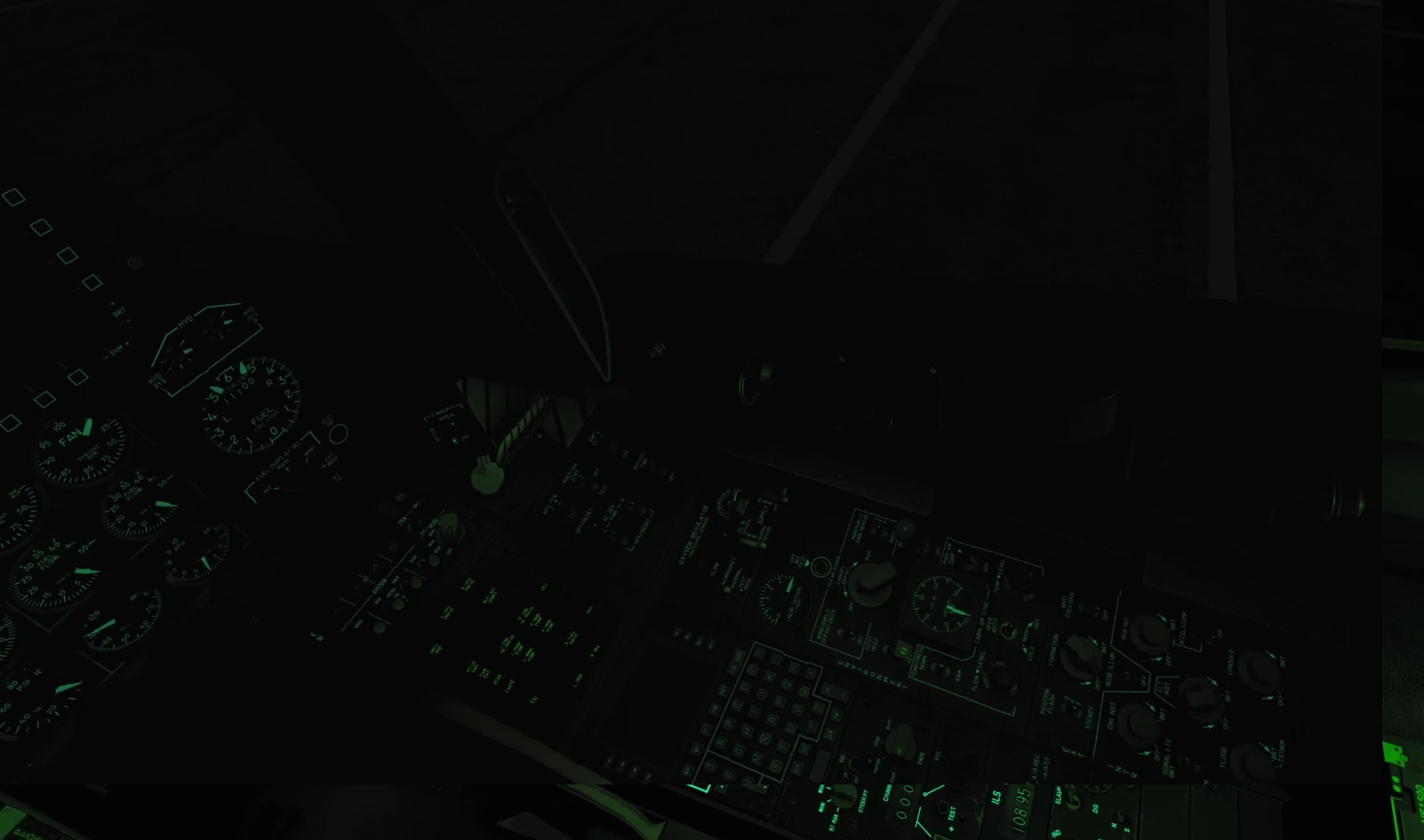
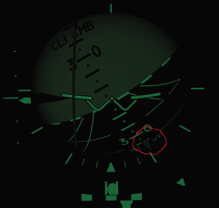
After the cockpit update the bank pointer in the ADI is not illuminated with interior lights turned on. The attached picture has been taken with interior light maxed out. In VR the pointer is not visible at all as the lighting in the new cockpit model is very dark. Also I'm not sure whether the steering bars are supposed to be dark as well. They are also barely visible at night with full interior light.
-
The bank pointer in the ADI is not illuminated though.
-
Yes, only waypoints stored in the CDU are shown on the TAD. This includes all waypoints downloaded from DTS and all waypoints or markpoints created after startup. If you want to have a waypoint for the TACAN source, you need to create one manually. You can use the TAD cursor for that. You might even find the TACAN source on the underlying map in the TAD or you use the bearing and range displayed by the HSI.
-
Ok, the magnetic declination is changing in DCS based on the date. It also seems that the values are quite close to the results from the magnetic declination calculator. So this clarifies at least that part ;-) Edit: After testing a few more values ... after 2016 the magnetic declinations in DCS are more and more deviating from the correct ones. It's probably because the declination drift has been increasing in the past 4 to 5 years and ED have not yet been incorporated any recent data than 2015. So even when I set the current date in DCS, the radial 269 is still the most accurate one for FYTTR.
-
Yes I noticed the note on the IFG that FLIP should be checked for current charts. I just assumed that FYTTR TWO would have had the radial 270. As I have actually not seen the original FYTTR TWO chart, it could be that this chart is using the 269 radial. FYTTR TWO was active during 2014 and the magnetic declination is close enough to that of 2011.
-
I was actually missing that particular detail. I was not aware that DCS simulates the magnetic variance for different years. I always thought the state of the year 2011 was simulated. I will have a look at the files you mentioned and double check this.
-
Yes, amongst the community produced charts, yours are most accurate for the year 2011 in terms of radials. Still, there are some pixelated ones which are not ideal to read or for printout and I'm still struggling with the procedure names though. All charts I have seen so far from the community have been edited (name changes, frequency changes, radial changes). I am interestend in the original charts during the year 2011.
-
Let me rephrase. I suppose those charts have been correct at one time in the past (or are correct for the current ones). However, let's look at the historical/calculated data of the magnetic declination for the FYTTR navpoint. Let's assume that the FYTTR navpoint has always been at the following coordinates as it is advertised by several documents throughout the past: N 36 21.44 W 115 41.47 According to the Magnetic declination calculator the following magnetic declinations have been at this point over the past years (all data for July 1st of that year): 2004: 13° 14.52' East 2005: 13° 08.34' East 2006: 13° 01.92' East 2007: 12° 55.50' East 2008: 12° 49.08' East 2009: 12° 42.66' East 2010: 12° 36.24' East 2011: 12° 29.88' East 2012: 12° 23.52' East 2013: 12° 17.16' East 2014: 12° 10.74' East 2015: 12° 04.92' East 2016: 11° 59.70' East 2017: 11° 54.48' East 2018: 11° 49.26' East 2019: 11° 43.98' East Now, according to DCS ME the FYTTR point is at 281° true heading at 33 nautical miles of the Nellis TCN beacon. Applying the magnetic declination from the year of 2011 (which ED has chosen to take the magnetic declination data from for DCS) the magnetic heading would be 169°. This would be the same for the years from 2010 to 2014. FYTTR ONE was using DME 267/33 which would date this departure at around 2000. FYTTR TWO is supposed to have DME 268/33 for the years thereafter until DME 269/33 should have been valid around 2011 with at least FYTTR THREE. The Red Flag IFG from the DCS documents area lists FYTTR ONE. The NellisAFB Instructions NELLIS AFB11-250 from 2016 mentions FYTTR TWO together with FYTTR LOW (and shows DME for FYTTR at 270/33). So there is a jump from 267 to 270 with nothing in between and this is what I'm struggling with. I would like to compile a proper FLIP for 2011 with the correct DMEs for this year as it is simulated and I would love to use the proper departure names as they were active and valid during this period.