
Land0
-
Posts
10 -
Joined
-
Last visited
-
I've noticed that the artificial horizon is often not aligned with the horizon. Usually because it does not erect properly after engine start and remains toppled.
-
 Agreed, I get this happening from about +6 lb/sq in boost. Difficult to have an economical cruise if I can only use the maximum continuous power setting without a horn.
 -
I also had this
-
DCS: de Havilland DH.98 Mosquito FB Mk VI Discussion
Land0 replied to msalama's topic in DCS: Mosquito FB VI
Does anyone know, or have sources for the history of the Mosquito during the Normandy campaign? Did it operate from UK bases or move to France as the fighters did? -
DCS: de Havilland DH.98 Mosquito FB Mk VI Discussion
Land0 replied to msalama's topic in DCS: Mosquito FB VI
April would be Q2. Hoping to see something by the end of March, but given no more info and it having already being delayed from the end of 2020, perhaps it has in fact been delayed further. I’d certainly expect to see more pictures/videos by now. -
DCS: de Havilland DH.98 Mosquito FB Mk VI Discussion
Land0 replied to msalama's topic in DCS: Mosquito FB VI
Yeah, I've been really disappointed too with the lack of updates/screenshots. Seems to be more coming out about Marianas and the Hind. I hope they start the hype train and video previews on youtube rolling soon! -
+1
-
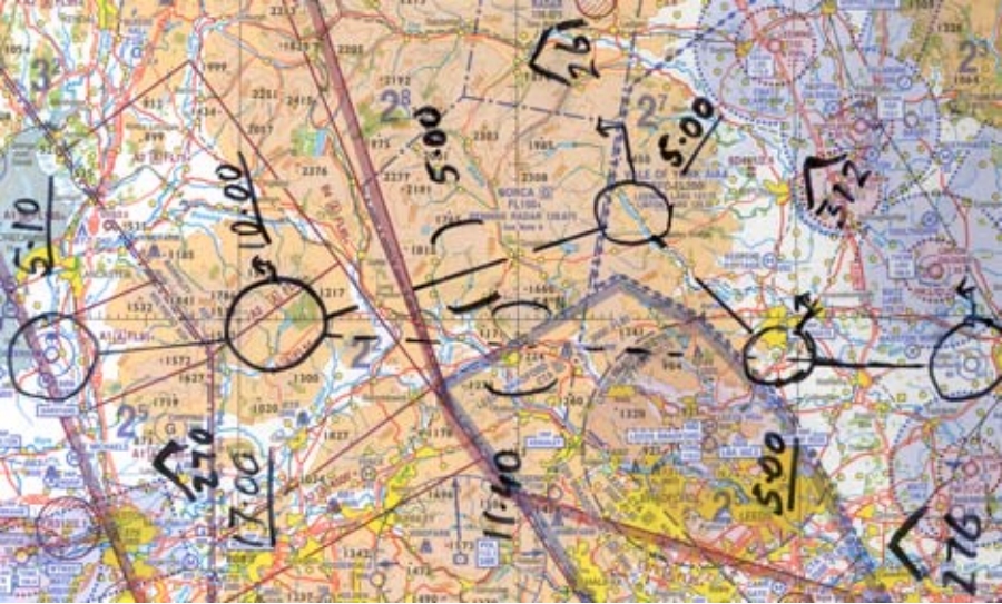
As DCS WW2 is growing rapidly and high performance long range aircraft such as the Mosquito are added, I think its time that we payed some attention the the F10 map and knee board in order to streamline the experience of operating these aircraft proficiently. WW2 birds rely heavily on map reading ability, visual fixes and a navigation technique called dead reckoning (flying preplanned legs on a heading at a certain speed for a certain time) to get to the target area and back home. My own experience with aerial navigation is from flying light aircraft. Although the moving map is quickly becoming standard, older map and stop watch navigation techniques are still taught and retained as far as possible as a back up. My suggestions: Kneeboard shows up on the pilots lap where it would be in real life as opposed to a 2D overlay. Direct view of F10 map available on the kneeboard on pilots lap which can be moved and zoomed with the mouse as needed. A great difficulty I have noted when flying warbirds is being splashed to a full screen map whenever I need to check my position or get a visual fix. This results in vastly diminishing my situational awareness and control of the aircraft which unlike modern fly-by-wire counterparts requires almost constant input from the pilot. This is even more startling in VR, especially during low level nav! Nav route of multiple legs can be drawn on the kneeboard along with annotations such as speed, heading, distance, hazards, targets, ETA time etc(example of a nav plot attached). Perhaps also the ability to generate a PLOG from this. A sortie planning mode where players can plan and brief the sortie together before flying it and share different information on the map screen depending on their tasking/group. I believe these ideas can be incorporated fairly easily and would benefit massively the experience of operating any aircraft in DCS, in particular the warbirds. Please do post any critique or developments on my suggestions and hopefully ED can consider them and pick them up if suitable. What an exciting time for DCS this is with so much on the horizon.

- 1 reply
-
- 3
-

-

-
Agreed!
-
From what I gather a lot of the navigators job was to keep his head on a swivel and in particular ensuring there were no fighters diving on the six o'clock position. I would like it if ED could give the navigator (when not crewed by another player) at least very basic functionality such as calling out enemy aircraft that they see/detect. "3 o'clock high!" etc. In much the same fasion as Jester on the F14 does - but I'm not expecting anything anywhere near as complex as Jester.
- 4 replies
-
- 10
-