trujillostm
-
Posts
162 -
Joined
-
Last visited
Content Type
Profiles
Forums
Events
Everything posted by trujillostm
-
I can see you are good in progress... I use .png files on Abris map, of 1024x1024 resolution every square. You can use max. zoom in Abris and F10 map to see very well the textures. LOD is Level Of Detail... Lod0 is level 0 and Lod2 is level 2. You can define the height when you see the texture of lod1 and lod2... I use only Lod0 to all textures... by now.
-
About the last window error: You need to select All objects when you export.
-
To create the Abris and F10 map: You need to create other .max file and put a Plane of 10x10 km in every square. Convert to Editable Mesh. You apply your texture of the map to every square. Select all. Material: Land_Map Semantics: Land. Level of detail: 0 Select all if not, and export to land_map_L0.sup Then select all and set Level of Detail: 2. Select all if not, and export to land_map_L2.sup Copy and paste .sup files in: ..\Eagle Dynamics\Ka-50\Bazar\Terrain\Map

-
You need to place the ka-50 very hight. I think you are below the terrain... The squares must be near Z = 0... (dou you use the template?)
-
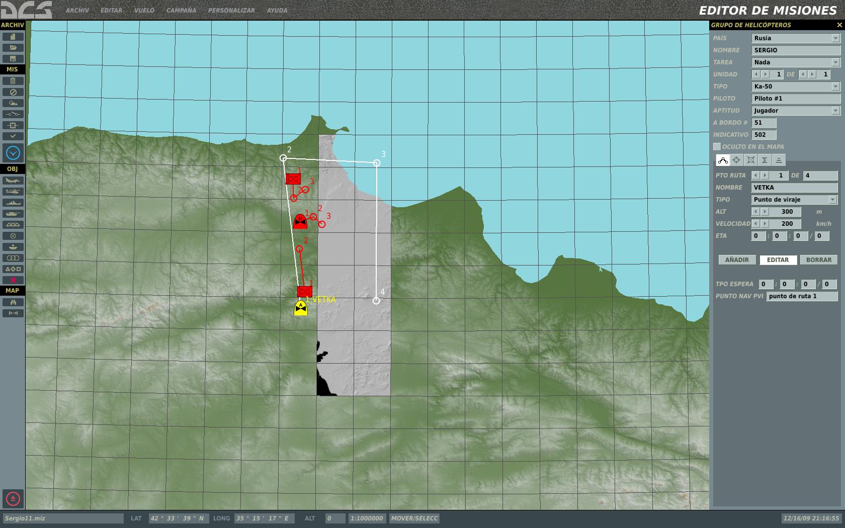
The problem is to find your squares... You can use the textures of the game, in one cdds. Extract one texture and apply to the terrain, and export to land.lsa2. Pplease, find the zone of your terrain... See the map of my test mission... You need to play the mission on the good square !!
-
Find the square. About 41º 42' 44'' N 35º 16' 49'' E.
-
Yes, you must insert on a CDDS file with the CDDS Studio. Every square in 3dsmax is a "real" square in the game. All squares in 3dsmax have x and y coordinates. In the game, x and y represents lat. long. coordinates.
-
You need to load "materials.lma.lua" in Plugin (opens a notepad window, you can close). Select the 3d terrain of squares and set to "Surface" and "Land". In my scenery, I'm using Sea and Lake too. Optimice the Editable Mesh... Can you play your scenery? It's so easy when you know the correct process.
-
PDA screen is very very small... You can use a small-medium TFT with touchscreen. It's better.
-
Don't name the land.lsa2 to another name. Use land.lsa2 not Nis.lsa2 You need to place the land.lsa2 file in the folder \Ka-50\Bazar\Terrain\Surface. Rename the original file to another name. Create the CDDS files and place there too. Place all your textures into the CDDS. Edit the graphics.cfg file on \Ka-50\Config and add the cdds like the others. Very important: create your own mission, and place your Ka-50 in correct coordinates. Run the game...
-
You need a monitor to connect the VGA or HDMI to your graphics card. The OS of a PDA is very small...
-
Do you know how to create the Mesh and set the UVW Mapping to the Coastline?
-
How to create the beach between land and sea? Are there Aditional Surfaces? In EffecttexturesTGA.cdds are the tga files of beach animation.
-
You are using Surface&Noise... I'm using Surface in my terrain. What's the difference? Test with only "Surface" not "Surface&Noise"...
-
Hi. I'm creating my own dcs scenery. I'm using aero-photos of my country. You can see my thread on the forum "Mods and Addons". The map of Mission Editor is very different to ABRIS and F10 view. I want to place objects in perfect position. Can you create a new Mission Editor tool?
-
Can you extract the ka-50 3d model?
-
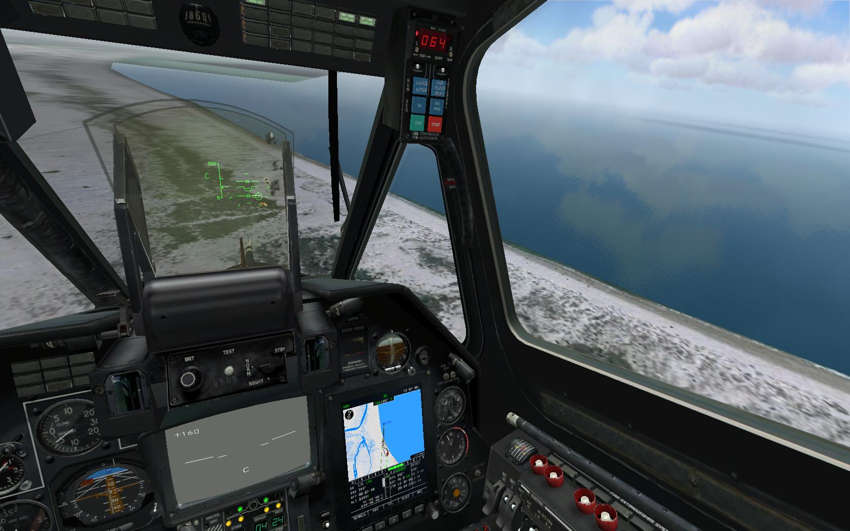
Flying over the beach... And dropping bombs on the beach and the sea.
-
Error: AssembleScenes.exe - Entry Point Not Found The procedure entry point ?error_black@misc@@3PBDB could not be located in the dynamic link library edCore.dll
-
You only need to replace the existing files with the new files. About 3d models, I don't know by now, the are in .lom files. I want more information from Eagle Dynamics....
-
Yo tambien llevaba tiempo buscando algo decente en helicopteros, pero lo que había no me convencía, era todo muy arcade, y por lo tanto me aburría. Creo que han detectado ese nicho de mercado, y mi sensación es que van a dar una buena sorpresa.
-
Creo que uno de los motivos de que muchos jugadores no tengan interés en los simuladores aéreos es el bajo nivel de calidad que se ha ofrecido siempre, lógico en este tipo de software tan complejo. Pero vamos viendo que el hardware es cada vez más potente, y más asequible, y además se hace buen software que lo aprovecha, como la serie DCS, que cada día me impresiona más. Además, cada día las aeronaves reales se hacen más sencillas para el piloto, por lo que es más factible a usuarios particulares poder aprender y sentir el vuelo. Llegará el momento en que no podamos diferenciar bien entre lo que es real y lo que es virtual. Este mundillo es apasionante.
-
The Mesh and the Dummy are linked... I don't know why. I think plugin could be developed to export with only the Mesh. I'm naming the 16 objects like "L0_Mesh_01" and "L0_Dummy_01". And they are in two 3dsmax Layers: "Mesh" and "Dummy". I love layers ;-) The name of .max files are with my UTM coordinates (x 10000 km): "mycity_021-411_024-414.max" 3dsmax crash if you use very much objects in the same scene. The Abris + F10 map are in other .max
-
You need to change the default land.lsa2 by your new land. And the land_map_L0.sup and land_map_L2.sup. land.lsa2 is for terrain, and .sup are for Abris map. The squares of 10x10 km in .max files (for .ls2 and .sup) need to be in the same position.
-
I have my own .sc from a .max file. I want to create the High.scn file with trees over my terrain.
-
Other error: "The procedure entry point ?error_black@misc@@3PBDB could not be located in the dynamic link library edCore.dll"