buur
-
Posts
625 -
Joined
-
Last visited
Content Type
Profiles
Forums
Events
Everything posted by buur
-
Follow your instructions and get the Essex class carrier. But no luck with airbases when I use the preset channels. Try to get the airbases manually with the C-26 remote controller. Found the airbases on following frequencies (if the ARC-5 shows frequencies) which not compare to the normal ATC frequencies found on the map. ANA 225; map. 250 KRD 238; map 251 Nov 249; map 252 Kry 261; map 253 MAY 275; map 254 Think there is a problem in the programming of the navigation radio. @scoobie to help your brain try a morse tree for your kneeboard: https://www.digitalcombatsimulator.com/en/files/3345609/
-
This is not the solution for the above mentioned bug.
-
done a mission with the radio settings from the manual on Caucasus (page 37) and can hear only Anapa and this on all channels. Testing it on Marianas WWII only Agana is detectible.
-
Carrier homing sectors with morse codes on the kneeboard
buur replied to Knubinator's topic in Wish List
maybe this version https://www.digitalcombatsimulator.com/de/files/3345609/ -
Das ausgefahrene Fahrwerk dient als Airbrakes. Werden auch nur die vorderen Räder ausgefahren.
-
check your coalition tab if Japan is listed as enemy/friend or neutral. Sounds like Japan was a neutral country in your mission.
- 1 reply
-
- 1
-

-
Die CASE III Coms waren mal irrtümlich bei der Tarrawa dabei. Aber waren nie wirklich funktionell. Das haben die dann später wieder rückgängig gemacht.
-
In real live there is a lot of tables where you can find such parameters. But it is a lot of work and the bombing tables in DCS aren't that realistic.
-
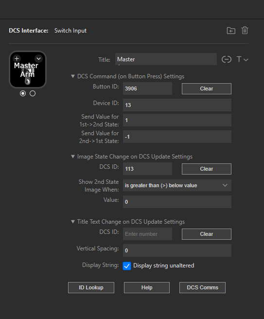
Stream deck (or the script in the plugin) can read the clickable.lua where the button are described. The export script send the state of the buttons (on/off) to the stream deck. If you look in the export script you see [113] = "%1d", -- Master arm. The 113 is the DCS ID. You found these value also with the ID Lookup. Oh, and I see that I have forgotten to delete some lines from the Gazell export script, which I had used as basis for the Corsair.
-
here is a luaF4U-1D.lua for the first 6 buttons. just for beginning nulland here the input for a button

-
mk82, 83 bombs explosion radius too large after update?
buur replied to SalakauHeadman's topic in Weapon Bugs
Problem with the bombs in DCS is that they have only splash damage and no fragmentation damage. If they have now updated the damage radius to the real world ones, than this are good news. -
didn't know such a tutorial. Learning from the other scripts ...
-
From the manual: What is the speed of your ship?
-
some one have to create a export script for the F4U. Otherwise streamdeck is not working.
-
All your inputs into the game is depending to your frame rate. Button down is detected in the first frame, button release in the second. If you have 10 frames per second on your pc than it is like you have pressed the button for 0.1 seconds. If your pc hat 100 frames per second it is like you have pressed the button for 0.01 seconds. With a higher frame rate your trim is much more sensitive. And therefore we have all individual computers the trim speed is different for each individual player. There is a smallest input possible depending on the frame rate. And this is what you feel as trim sensitivity.
-
in the doc folder. \DCSWorld\Mods\aircraft\F-86\Doc
-
wie üblich im Ordner Mods/Aircraft/F4U-1D/Doc
-
You find these files also on the NOAA site and also some explanations how to compute them.
-
it seems that the magnetic declination used by ED is off from the real world declination. And no one knows with model ED is using. You can check your charts with this website to see if the charts are correct. https://www.ngdc.noaa.gov/geomag/calculators/magcalc.shtml
-
nur 72.... na da hab beim mancher map übrer 200
-
MissionEditor: Goto Map Town and Village
buur replied to uboats's topic in Texture/Map Mods for DCS World
Very nice idea and solution. Have to check if we could your method also for things like special waypoints and so on. -
For the mental calculations: This works only if you are familiar with the airplane. If you are mission designer and have to works with planes you don't know you need the help of a good mission planning tool. And also, when I do the calculation in my head I don't need a mission planning tool.
- 16 replies
-
- 2
-

-
- combatflite
- fragorders
- (and 2 more)
-
Interesting topic. Unfortunately I have no standard mission planning tool. No one of the above mention do complete satisfy my needs. I always use only parts of the programs, mostly for generating kneeboards. What I really miss in the mission planning tools is a good calculation on flight times based on the performance data of the aircraft. I mean things like time to climb, distance to climb and so on and so on. At the moment we need a lot of trial and error for mission with a time on target or a precise rejoin mid air. Done this partly for the Harrier and it is a big help for mission planning if you can calculate the timing. Below an example what you need for precise planning.
- 16 replies
-
- 2
-
-
- combatflite
- fragorders
- (and 2 more)
-
Vielleicht solltest du dir mal das Manual anschauen. Findest du im Ordner DCSWorld/Doc.null
-
jetzt wundert es mich wie es beim ersten mal anfunken geklappt hat bei deiner Fehlerbeschreibung